

Mori Atlas logo
Wildlife reserveRéserve spéciale du Pic d'Ivohibe

Understanding the mountain massif and hydrological role of this protected wilderness area

Réserve spéciale du Pic d'Ivohibe Wildlife Reserve: Geography and Protected Landscape Atlas

Réserve spéciale du Pic d'Ivohibe is a significant protected area in the Ihorombe region, defining the southern extension of the Andringitra massif. This wildlife reserve serves as a critical water catchment, anchoring the local ecology through its abrupt topography and condensation-driven microclimate. Spanning diverse elevations, the landscape encompasses humid evergreen forests, montane thickets, and rupicolous vegetation that support localized lemur species and endemic flora.

humid tropical forestmountain massiflemur habitatwatershed protectionsoutheast MadagascarIhorombe region
A stylized illustration showing a lush green mountain valley with terraced fields in the foreground, a winding path, and a high cliff face under a soft sunset sky.

Réserve spéciale du Pic d'Ivohibe

Wildlife reserve

Park overview

Structured park overview, official facts, and landscape profile for Pic d'Ivohibe Special Reserve

Pic d'Ivohibe Special Reserve park facts, protected area profile, and essential visitor context

Review the core facts for Pic d'Ivohibe Special Reserve, including designation, size, terrain, visitor scale, habitats, and operating context in one park-focused overview.

About Pic d'Ivohibe Special Reserve

Pic d'Ivohibe Special Reserve is a small but ecologically significant protected area in the Ihorombe region of south-central Madagascar, anchored on the steep massif of Pic d'Ivohibe. Although the reserve covers only about 3,453 hectares, its landscape context gives it an outsized role in the regional ecosystem. The massif forms the southern tail of the Andringitra chain, and its rugged summit acts as a barrier to the prevailing easterly trade winds. The result is a localized zone of intense precipitation and persistent cloud condensation on the slopes, an environmental dynamic that shapes the entire ecological character of the protected area.

The reserve extends across the central and eastern ecozones of Madagascar. Lower and mid-elevation slopes are draped in dense humid evergreen forest, shaped by the abundant moisture that the massif captures. Higher and more exposed zones give way to rocky outcrops and rupicolous vegetation, including open formations dominated by xerophytic chamaephytes, succulents, and sclerophyllous plants. Montane ericoid thickets and secondary shrublands further diversify the habitat mosaic, illustrating the transition from humid tropical forest toward the more xeric southern highland flora.

Administratively, the reserve has been managed by Madagascar National Parks since its creation in 1964 and has operated under a collaborative co-management model involving local community members through a local park committee and an orientation and support committee for protected areas. Marker surveys were completed in 2001. The reserve is recognized for its biodiversity significance, with eight lemur species recorded, and for its watershed value, with local rivers originating on the massif that support agriculture and daily life in surrounding communities. Its location, just 5 kilometers east of the town of Ivohibe and easily visible within the broader protected-area network of Madagascar, makes it a quiet but important node in the country's system of natural reserves.

Quick facts and research context for Pic d'Ivohibe Special Reserve

Pic d'Ivohibe Special Reserve lies in the Ihorombe region of Madagascar, about 5 kilometers east of the town of Ivohibe and managed by Madagascar National Parks under a collaborative co-management framework with local communities. Established on 16 September 1964 by decree 64-380, the reserve covers roughly 3,453 hectares over the central and eastern ecozones of the island. Its protected landscape includes low- and mid-altitude humid tropical forest, montane ericoid scrub, and rupicolous vegetation on rocky outcrops. The massif is recognized both as a biodiversity hotspot supporting eight lemur species and as a strategic water-catchment zone feeding the Menarahaka and Iantara river systems.

Protection and recognition

Documented terrestrial protection scope, management records, and regulatory framework

Protection Status and International Recognition for Réserve spéciale du Pic d'Ivohibe

Terrestrial protection status, management parameters, and official recognition records define the conservation framework for Réserve spéciale du Pic d'Ivohibe. Documented regulatory details provide verified baseline facts for this protected natural area.

Protection details

Protection scope
Terrestrial
Transboundary protection
No
WDPA ID
5029
Park context

Deeper park guide and search-rich context for Pic d'Ivohibe Special Reserve

Pic d'Ivohibe Special Reserve history, landscape, wildlife, and travel context

Explore Pic d'Ivohibe Special Reserve through its history, landscape character, ecosystems, wildlife, conservation priorities, cultural context, and seasonal travel timing in a structured park guide built for atlas discovery and search intent.

Why Pic d'Ivohibe Special Reserve stands out

The reserve is best known for its role as the southern extension of the Andringitra chain and for the condensation-driven microclimate created by the abrupt Pic d'Ivohibe summit. This microclimate sustains humid evergreen forests that harbor southeast-Madagascar-restricted lemurs such as Milne-Edwards's sifaka and Peyrieras's woolly lemur, along with endemic plants and fungi that remain incompletely documented. Equally distinctive is its function as a watershed: the massif concentrates rainfall and feeds tributaries of the Menarahaka and Iantara rivers, a service on which roughly 2,500 surrounding residents depend.
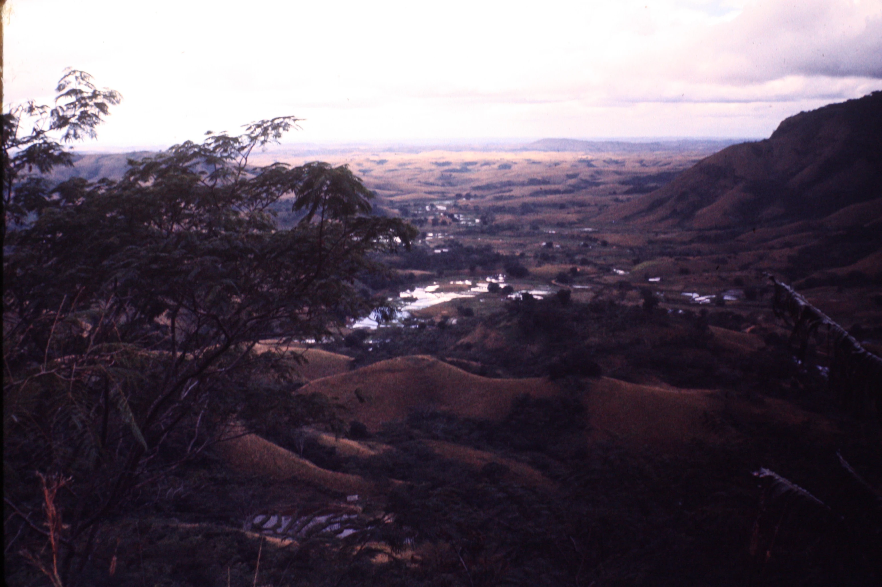
A high-angle view looking over a valley with rolling hills, a winding river reflecting light, and distant mountains under a soft light.
A wide view of the rolling hills and river valley landscape in the vicinity of Ivohibe, Madagascar.

Pic d'Ivohibe Special Reserve history and protected-area timeline

Pic d'Ivohibe Special Reserve was formally created on 16 September 1964 through decree 64-380, with an initial surface area of 3,453 hectares. The designation placed the southern extension of the Andringitra mountain chain under formal protection under Madagascar's earlier system of government-managed reserves.

A later milestone came in 2001, when the reserve's boundary markers were physically laid out on the ground, giving the protected area a tangible administrative perimeter for the first time. Since then, management has been progressively restructured under Madagascar National Parks, the national agency that oversees the country's network of protected landscapes. The current model is one of collaborative co-management, in which local communities participate through a local park committee and a broader orientation and support committee for protected areas, integrating conservation goals with local development priorities.

Pic d'Ivohibe Special Reserve landscape and geographic character

The landscape of Pic d'Ivohibe Special Reserve is defined by the abrupt, rocky summit of the massif itself, which forms the southern section of the Andringitra chain and rises sharply enough to interrupt the prevailing easterly winds across the region. This topographic obstacle creates a pronounced microclimatic gradient on the mountain's flanks, with the eastern slopes receiving concentrated rainfall and frequent cloud cover while more sheltered zones transition into drier formations.

The protected area encompasses a layered habitat mosaic. Lower elevations are covered by dense humid evergreen tropical forest of low and mid-altitude types, sustained by the moisture that condenses against the massif. Higher elevations support montane ericoid thickets and secondary shrublands. The most exposed sites give way to rupicolous vegetation, an open and discontinuous cover dominated by xerophytic chamaephytes, succulents, and sclerophyllous plants adapted to thin, rocky soils. Several rivers and important tributaries of the Menarahaka and Iantara systems rise on the slopes of the massif, anchoring the landscape's hydrological role in the wider Ihorombe region.

Pic d'Ivohibe Special Reserve ecosystems, habitats, and plant life

Pic d'Ivohibe Special Reserve bridges the central and eastern ecozones of Madagascar, producing a habitat mosaic that is unusually compressed into a small protected footprint. The humid forests of the lower and mid-elevation slopes absorb the moisture generated by wind condensation against the Pic d'Ivohibe massif, while the exposed rocky crests and upper slopes carry a distinctly drier rupicolous flora dominated by xerophytic chamaephytes, succulents, and sclerophyllous plants.

The vegetation pattern reflects both the local microclimate and the reserve's position on the southern edge of the Andringitra chain. Low-altitude and mid-altitude dense humid evergreen forest intergrades with montane ericoid thickets and secondary shrublands on disturbed sites, while specialized rocky-outcrop vegetation occupies the most exposed surfaces. The reserve is also noted for harboring poorly cataloged or undescribed species of fungi and plants, suggesting that its ecological inventory remains incompletely documented despite decades of formal protection.

Pic d'Ivohibe Special Reserve wildlife and species highlights

The reserve supports a rich assemblage of southeast-Madagascar wildlife, with eight lemur species documented across its forest habitats. Among these, Milne-Edwards's sifaka (Propithecus edwardsi) and Peyrieras's woolly lemur (Avahi peyrierasi) are characteristic species whose distributions are largely restricted to the southeast of the island, giving the reserve regional importance for primate conservation.

Although no strictly endemic vertebrates have so far been identified, the reserve's broader fauna contributes meaningfully to Madagascar's biodiversity patterns. Bird species typical of humid eastern forest, such as the brown mesite (Monias benschi), occur within or near its boundaries, alongside raptors like the sooty falcon. Invertebrate diversity is also notable, with groups such as the diving beetles of the genus Copelatus represented in aquatic microhabitats on the massif. The combination of evergreen forest cover, rocky outcrops, and the riverine network that originates on the slopes supports a layered community of mammals, birds, reptiles, amphibians, and invertebrates, even if many of its species remain poorly studied.

Pic d'Ivohibe Special Reserve conservation status and protection priorities

Pic d'Ivohibe Special Reserve is one of the older protected areas in Madagascar, having been formally designated in 1964 and brought into a modern management framework with the laying out of boundary markers in 2001. Its current administration under Madagascar National Parks operates through a collaborative co-management approach, engaging local communities through a local park committee (CLP) and an orientation and support committee (COSAP) that link conservation with regional development priorities.

The reserve's conservation value extends beyond its modest size. The humid forests sustained by the massif act as a buffer against the broader advance of deforestation in the Ihorombe region, while the rocky uplands protect a distinctive rupicolous flora. The massif's role as a water-catchment zone is equally strategic, as the rivers and tributaries that rise here feed the regional Menarahaka and Iantara systems on which an estimated 2,500 local residents depend. In this sense, the reserve is recognized as much for its ecological services (watershed protection, condensation dynamics, and forest continuity) as for its wildlife values.

Pic d'Ivohibe Special Reserve cultural meaning and human context

The reserve is embedded in a rural landscape of south-central Madagascar where local communities have a direct stake in the management of natural resources. Under the collaborative co-management framework applied by Madagascar National Parks, residents participate in both conservation activities and development planning through local committees, reflecting the integration of protected-area governance with everyday rural livelihoods. The presence of about 2,500 people who draw on the reserve's ecological services, especially its water resources and forest products, anchors its cultural relevance within the Ihorombe region.

Top sights and standout views in Pic d'Ivohibe Special Reserve

The reserve's standout features include its role as the southernmost extension of the Andringitra chain and the unique condensation microclimate generated by its abrupt summit. Within its 3,453 hectares, it compresses a remarkable range of habitats: low- and mid-altitude humid evergreen forest, montane ericoid thickets, secondary shrublands, and rupicolous formations dominated by succulents and sclerophylls. Its biodiversity profile includes eight lemur species, including Milne-Edwards's sifaka and Peyrieras's woolly lemur, and an incompletely documented flora and fungi assemblage that continues to draw scientific interest.

Best time to visit Pic d'Ivohibe Special Reserve

The climate of the reserve is classed as tropical humid on its eastern flank, with an average annual temperature around 23 degrees Celsius. Rainfall and condensation are closely tied to the easterly wind pattern that the massif intercepts, so the dry season, generally from roughly April to October in southern Madagascar, tends to offer the most stable conditions for landscape viewing and forest exploration. The wetter months bring heavier precipitation and deeper cloud cover over the summit, which can make trails more demanding but also heightens the lushness of the humid forest belt.
Monthly climate preview

Long-term temperature ranges and monthly precipitation averages across the park coordinate

Réserve spéciale du Pic d'Ivohibe Climate Normals and Annual Weather Patterns

Historical data from 1991 to 2020 documents the measured annual temperature rhythm and monthly precipitation variations across a representative coordinate in Réserve spéciale du Pic d'Ivohibe. Examining the complete twelve-month climatology profile provides deeper analytical context for long-term meteorological patterns at this specific elevation.
Annual mean19 °C
15 °C23 °C
Jan23°
Feb22°
Mar22°
Apr20°
May18°
Jun16°
Jul15°
Aug16°
Sep17°
Oct20°
Nov21°
Dec22°
Warmest month
January

22.5 °C

Coolest month
July

14.9 °C

Wettest month
February

11.8 mm/day

Driest month
September

1.6 mm/day

Park location guide

Geography guide, regional context, and park location map for Pic d'Ivohibe Special Reserve

Pic d'Ivohibe Special Reserve park geography, regions, and map view in Madagascar

Understand where Pic d'Ivohibe Special Reserve sits in Madagascar through a broader geographic reading of the surrounding landscape, nearby location context, and its mapped position within the national park landscape.

How Pic d'Ivohibe Special Reserve fits into Madagascar

Madagascar is an island nation in the Indian Ocean, positioned off the southeastern coast of Africa. As the world's fourth-largest island and second-largest island country, it stands out for its exceptional biodiversity, over 90% of its wildlife is endemic, making it one of 17 megadiverse countries. The population is approximately 32 million, with Antananarivo as both the capital and largest city.

Wider geography shaping Pic d'Ivohibe Special Reserve in Madagascar

Madagascar lies in the Indian Ocean off the southeastern coast of Africa, separated from the mainland by the Mozambique Channel. The island is situated approximately 400 km from the African continent. As the world's fourth-largest island, it also includes numerous smaller peripheral islands.

Map view of Pic d'Ivohibe Special Reserve

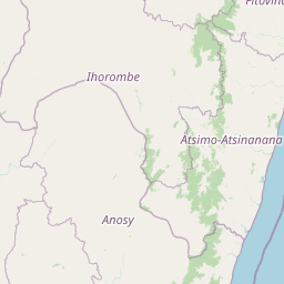
Use this park location map to pinpoint Pic d'Ivohibe Special Reserve in Madagascar, understand its exact geographic position, and read its mapped placement within the surrounding landscape more clearly.

Pigeon | © OpenStreetMap contributors

Location context for Pic d'Ivohibe Special Reserve

Ihorombe

Visualizing the rugged mountain terrain, cloud forests, and highland habitats

Réserve spéciale du Pic d'Ivohibe Photos and Mapped Landscape Scenery

Photographic archives capture the steep mountain terrain and humid forest habitats defining Réserve spéciale du Pic d'Ivohibe. Visual records provide essential context for understanding the rugged topography, cloud-condensation microclimates, and protected ecosystems of the reserve.

A high-angle view looking over a valley with rolling hills, a winding river reflecting light, and distant mountains under a soft light.

Park atlas

Compare surrounding mountain massifs and regional conservation landscapes in south-central Madagascar.

Explore Protected Areas and Other Parks Near Réserve Spéciale du Pic d'Ivohibe

Browse nearby national parks and protected areas sharing the rugged terrain of the Ihorombe region. Continued map exploration reveals how adjacent reserves connect regional water catchments and forest habitats.
National parkHaute Matsiatra
About 20 km away#1 closest

North

Andringitra National Park: A Protected Landscape within Haute Matsiatra's Geography

Explore mapped park boundaries and regional terrain.

Andringitra National Park represents a vital protected area within the Haute Matsiatra region, contributing significantly to the mapped landscape of central Madagascar. Its designation as a national park underscores its importance for conservation and geographic study. Users exploring this destination can gain a detailed understanding of its specific protected boundaries, the surrounding natural terrain, and its overall contribution to the regional geography, making it a key site for atlas-based landscape discovery.

Area
311.6 km²
Established
1999
IUCN
II
Visitors
3.4K annual
Wildlife reserveAtsimo-Atsinanana
About 93 km away#2 closest

East

Manombo Special Reserve: Protected Geography and Coastal Forest Mapping

Southeastern Madagascar wildlife reserve and humid forest habitat.

Examine the ecological mosaic of Manombo Special Reserve, a protected wildlife area located in the Atsimo-Atsinanana region. This reserve features a distinctive split-parcel configuration across National Route 12, offering insights into lowland rainforest conservation, wetland systems, and the dense endemism of Madagascar's southeastern coastal geography.

Area
53.2 km²
Established
1956
IUCN
IV
National parkAtsimo-Atsinanana
About 110 km away#3 closest

South

Midongy du sud National Park: National Park in Atsimo-Atsinanana, Madagascar

Explore its protected landscape and mapped geography.

Midongy du sud National Park is a significant protected area located in the Atsimo-Atsinanana region of Madagascar. This entry provides detailed geographic context, focusing on the park's mapped boundaries and its identity as a national park. It supports atlas-based discovery by offering insights into the park's specific landscape and its regional setting within southeastern Madagascar, serving as a factual resource for understanding its protected status.

Area
1,922 km²
Established
1997
IUCN
II
Relief
Mountain
Wildlife reserveMadagascar
About 117 km away#4 closest

Southwest

Kalambatritra Special Reserve: Exploring the Geography of Southern Madagascar Protected Lands

Mapping a unique humid highland forest refuge

The Kalambatritra Special Reserve comprises a significant forested block in southern Madagascar, defined by ridges and valleys that maintain a humid microclimate. This protected area serves as a critical habitat for endemic wildlife, bridging the gap between eastern forest ecosystems and the drier terrain of the southern plateau, providing an essential study in island geography and conservation.

Area
282.55 km²
Established
1959
IUCN
IV
Scope
Terrestrial
National parkMadagascar
About 131 km away#5 closest

North

Ranomafana National Park: Madagascar's premier Tropical Rainforest Protected Area

Explore its unique mapped geography and landscape context.

Ranomafana National Park stands as a crucial national park within Madagascar's protected lands, safeguarding a significant expanse of tropical rainforest. This page offers a deep dive into its geographic setting, detailing the mapped boundaries and the distinctive natural terrain that supports its exceptional biodiversity. Discover the atlas value of this protected landscape for understanding regional conservation and geographic context.

Area
416 km²
Established
1991
IUCN
II
Climate
Tropical
National parkIhorombe Region
About 163 km away#6 closest

West

Isalo National Park: Explore Madagascar's Sandstone Canyons and Protected Landscape Geography

Discover unique geology, tapia woodlands, and regional park context.

Isalo National Park is a prominent protected area in Madagascar's Ihorombe Region, celebrated for its spectacular sandstone landscape. This national park features deep canyons, eroded rock domes, and striking runiform mountains, formed from ancient sedimentary deposits. The park preserves significant tapia woodlands and remarkable plant endemism, offering a rich context for understanding protected land distribution and Madagascar's unique geography. Its mapped terrain provides a visual atlas of natural wonders.

Area
815.4 km²
Established
1962
IUCN
II
Visitors
32.7K annual
National parkMadagascar
About 233 km away#7 closest

South

Andohahela National Park: Protected Landscape and Geographic Atlas Context in Madagascar

Explore the mapped terrain and regional park geography.

Understand Andohahela National Park as a distinct national park entity, focusing on its geographic setting and protected landscape characteristics within Madagascar. This detail page provides structured data on the park's mapped boundaries and its regional importance, offering insights for anyone exploring protected areas and natural terrain through a geographic lens. It is an essential resource for understanding the park's specific context in the broader atlas.

Area
760 km²
Established
1998
IUCN
II
Visitors
1.3K annual
National parkAtsimo-Andrefana
About 238 km away#8 closest

West

Zombitse-Vohibasia National Park: Protected Landscape and Regional Geographic Context

Mapped protected areas and natural terrain discovery.

Investigate Zombitse-Vohibasia National Park, a designated national park within the Atsimo-Andrefana region. This dedicated entry provides detailed geographic information, focusing on the park's mapped terrain and its contribution to the regional protected landscape. Gain insight into the park's atlas-relevant features and its specific place within Madagascar's conservation geography.

Area
363.08 km²
Established
2002
IUCN
II
Relief
Upland

Common questions about visiting, size, designation, and location context for Pic d'Ivohibe Special Reserve

Pic d'Ivohibe Special Reserve FAQs for park facts, access, geography, and protected area context

Find quick answers about Pic d'Ivohibe Special Reserve, including protected-area facts, park geography, trail and visitor context, and how the park fits into its surrounding country and regional landscape.
MoriAtlas Explorer

Continue Your Protected Areas Search Across the Global Atlas

Deepen your exploration by continuing the structured search for national parks and protected areas worldwide. Utilize the comprehensive filtering capabilities to compare different conservation landscapes and refine your understanding of global park geography. Discover more about the distribution and characteristics of protected natural areas.

Global natural geography