Mori Atlas logo
Wildlife reserveÁrea de manejo de hábitats y/o especies Rincón de Franquía

Mapping the riverine forests, floodplain mosaic, and transboundary protected habitats of northern Uruguay

Área de manejo de hábitats y/o especies Rincón de Franquía: A Strategic Triple Frontier Wildlife Reserve

Located at the confluence of the Uruguay and Cuareim rivers in Artigas Department, Área de manejo de hábitats y/o especies Rincón de Franquía serves as a vital ecological bridge between Uruguay, Argentina, and Brazil. This wildlife reserve protects a dense floodplain mosaic of riverine forest and seasonal wetlands, providing a critical refuge for rare seed-eating birds and diverse vertebrate populations. The area forms a functional node within a larger transnational network of protected landscapes, offering significant insights into riparian habitat connectivity.

riverine forestwetlandsfloodplainbird conservationtriple frontierriparian habitat

Área de manejo de hábitats y/o especies Rincón de Franquía

Wildlife reserve

Park overview

Structured park overview, official facts, and landscape profile for Rincón de Franquía Habitat and Species Management Area

Rincón de Franquía Habitat and Species Management Area park facts, protected area profile, and essential visitor context

Review the core facts for Rincón de Franquía Habitat and Species Management Area, including designation, size, terrain, visitor scale, habitats, and operating context in one park-focused overview.

About Rincón de Franquía Habitat and Species Management Area

Rincón de Franquía is one of Uruguay's most biologically intense small protected areas, and its identity is shaped as much by its geography as by its ecology. The reserve sits in the extreme northwest of the Artigas department, in the wedge of land where the Uruguay and Cuareim rivers converge near the city of Bella Unión. This corner of Uruguay has always carried a frontier character: it is a borderland facing Argentina across the Uruguay river and Brazil across the Cuareim, and it forms part of a larger mosaic of protected landscapes that span all three countries.

Ecologically, the area is defined by its floodplain setting and river dynamics. The reserve covers a flood plain of the Uruguay and Cuareim rivers with natural levees (albardones) and marginal lagoons, underlain by fine sediments, silty clays, old alluvial deposits, and sand. These physical conditions produce a varied habitat pattern, with elevated levees carrying more stable forest vegetation and low-lying depressions holding seasonal wetlands. Three principal vegetation formations can be distinguished: the riverine forest along the Uruguay river, the riverine forest along the Cuareim, and the open park woodland mosaic that gives the broader landscape its distinctive character.

The reserve's biodiversity is unusually rich for its size. Surveys have recorded about 223 bird species within Rincón de Franquía, which is roughly half of Uruguay's national bird checklist. The area also supports at least fifteen mammal species, twenty-one amphibian species, and fourteen reptile species, including several of conservation concern. Among the most ecologically significant records are the marsh seedeater, a globally endangered grassland bird that breeds in the area, and a single Uruguayan record of the green snake Phylodrias olfersi. The reserve's significance therefore lies not only in what it protects on its own land, but in its role as a core site for species whose populations extend across the river systems of all three bordering countries.

Because of this combination of intensive biodiversity, small size, and bicentennial location, Rincón de Franquía functions less as a classic wilderness park and more as a working ecological buffer and seed source for the surrounding floodplain. Its protection category as a habitat and species management area reflects that role: it is oriented toward maintaining ecological processes and habitat quality rather than toward wilderness preservation, and it forms part of Uruguay's approach to safeguarding riverside landscapes under increasing agricultural and urban pressure.

Quick facts and research context for Rincón de Franquía Habitat and Species Management Area

Rincón de Franquía is a habitat and species management area in the northwestern Artigas department of Uruguay, positioned at the confluence of the Uruguay and Cuareim rivers just north of Bella Unión. It was incorporated into Uruguay's National System of Protected Areas (SNAP) on April 17, 2013, by Decree No. 121/013, and previously held the status of a Departamental Reserve granted by the Bella Unión municipality in 2011. The reserve sits within the Campos de Bella Unión Important Bird Area, one of twenty-two IBAs in Uruguay recognized through Aves Uruguay and BirdLife.

The protected area covers roughly 1,150 to 1,229 hectares depending on the source figure, of which a substantial portion belongs to the Bella Unión municipality and is grazed or cultivated by smallholders under permits. Around 223 bird species have been recorded, approximately half of all species known from Uruguay, and the reserve also supports fifteen mammal species, twenty-one amphibian species, and fourteen reptile species.

Protection and recognition

Documented terrestrial protection history and management scope established in 2011

Área de manejo de hábitats y/o especies Rincón de Franquía Protection Status

Official records outline the terrestrial protection status and established designation history for Área de manejo de hábitats y/o especies Rincón de Franquía since 2011. Verified management parameters provide clear context for conservation research without relying on external recognition programs.

Protection details

Protection scope
Terrestrial
Designated year
2011
Transboundary protection
No
Park context

Deeper park guide and search-rich context for Rincón de Franquía Habitat and Species Management Area

Rincón de Franquía Habitat and Species Management Area history, landscape, wildlife, and travel context

Explore Rincón de Franquía Habitat and Species Management Area through its history, landscape character, ecosystems, wildlife, conservation priorities, cultural context, and seasonal travel timing in a structured park guide built for atlas discovery and search intent.

Why Rincón de Franquía Habitat and Species Management Area stands out

Rincón de Franquía is best known as a small but exceptionally rich riverine and wetland reserve that harbors around half of all bird species recorded in Uruguay within a single contiguous area. It serves as a critical refuge for threatened seed-eating birds such as the marsh seedeater (Sporophila palustris) and the chestnut-bellied seedeater (Sporophila hypochroma), which have become rare elsewhere in the country. The reserve also stands out for its position at a continental triple frontier, linking Uruguayan protected lands with the Espinilho ecosystem of southern Brazil and the Miriñay wetlands of northeastern Argentina.
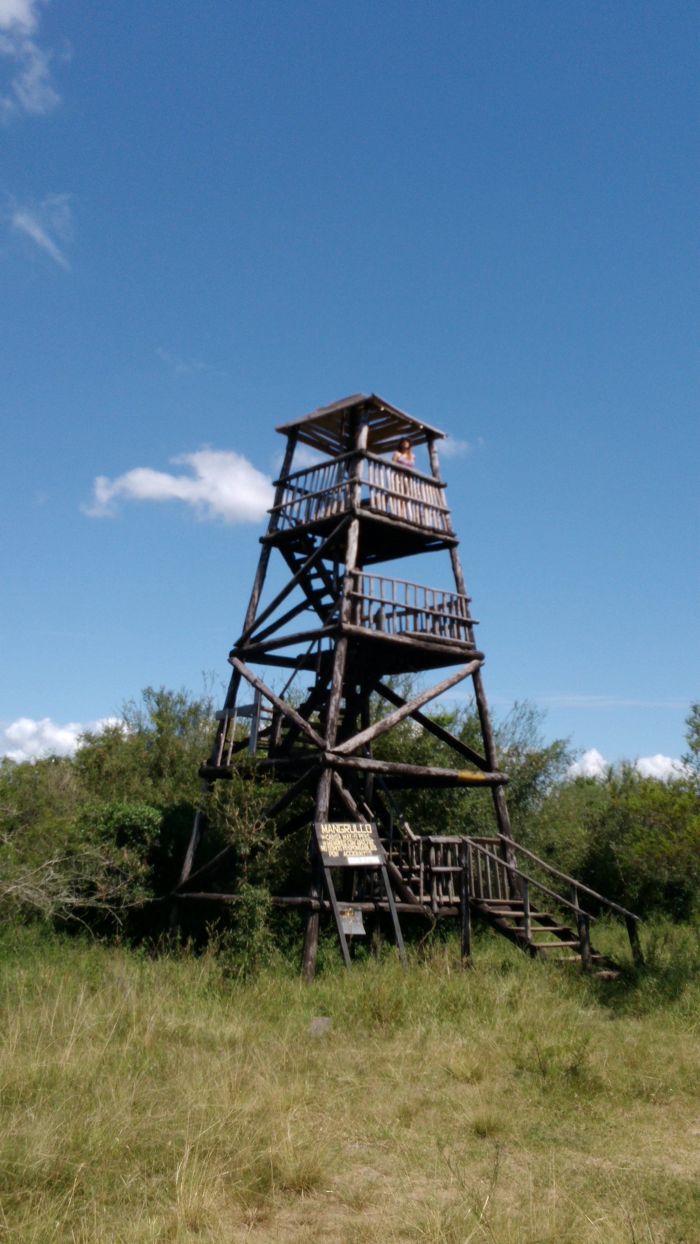
A tall, multi-level wooden observation tower with a staircase stands in an open grassy area with trees and a clear blue sky in the background.
A wooden observation tower stands within the Rincón de Franquía habitat management area, providing a vantage point for viewing the surrounding landscape.

Rincón de Franquía Habitat and Species Management Area history and protected-area timeline

Rincón de Franquía emerged from a community-led initiative rather than from a top-down designation. In 2004, a group of residents from the nearby city of Bella Unión drew up a project titled "Creation of a Natural Protected Area and a Linear Park in the Franquía Zone, Bella Unión", motivated by visible degradation of the riverside forests near the mouth of the Cuareim river where it empties into the Uruguay. The proposal aimed to formally protect the junction area while also creating a linear park along the Uruguay riverbank connecting to a local riverside recreation area.

The initiative gained institutional traction in the following years. On 25 February 2011, the Bella Unión municipality formally declared the area a Departamental Reserve, giving it a first layer of formal protection. The proposed incorporation into Uruguay's national system was presented to the National Advisory Commission on Protected Areas in July 2011, after a public hearing held in Bella Unión in March of the same year. The reserve was then officially integrated into the National System of Protected Areas on 17 April 2013, under the habitat and species management category, through Decree No. 121/013.

Alongside its formal protections, the area has long functioned as a place of recreation for Bella Unión residents, with uses ranging from camping and fishing to gathering firewood from the native forest. The reserve's history therefore intertwines a traditional local cultural landscape with a more recent conservation framework that seeks to sustain biodiversity, local livelihoods, and environmental education within the same territory.

Rincón de Franquía Habitat and Species Management Area landscape and geographic character

Rincón de Franquía occupies a floodplain landscape shaped by two major rivers. The terrain belongs to the Arapey geological formation and is essentially a flood plain of the Uruguay and Cuareim rivers, marked by natural levees along the riverbanks and by marginal lagoons and depressions further inland. The substrate is composed of fine materials: silty clay sediments, older alluvial deposits, and sandy layers laid down by shifting river channels.

The visual character of the area is dominated by the waterways that define its edges. The Uruguay river forms the western boundary of the reserve, while the Cuareim follows part of the northern edge before joining the Uruguay just downstream of Bella Unión. Together with the rivers come the levees and the broader riparian corridor: elevated strips of riverine forest running along the banks, transitioning into lower, more open terrain where seasonal pools form.

To the south the reserve approaches the city of Bella Unión, and a designated linear park runs along part of the Uruguay riverside, including the Los Pinos bathing area. Surrounding the reserve on the international side are two other ecologically significant landscapes: Brazil's Espinilho State Park on the opposite bank of the Cuareim, and Argentina's General Ávalos Field near the mouth of the Miriñay river. The combined effect of these features is a landscape in which forest, water, and political boundaries are tightly interwoven.

Rincón de Franquía Habitat and Species Management Area ecosystems, habitats, and plant life

The ecological identity of Rincón de Franquía is fundamentally a riverside and floodplain identity. The three principal vegetation formations are the riverine forest along the Uruguay river, the riverine forest along the Cuareim river, and a more open park woodland mosaic that occupies the interior of the flood plain. Together these create an ecologically diverse mosaic within a relatively small area, where habitat type can change over short distances between riverbank, levee, and seasonal wetland.

A total of around 54 woody species have been recorded in the area, including species such as the timbó blanco (Albizia inundata), which forms part of the taller riparian forest canopy. The riverine forests are particularly important because they edge the active flood zone and have historically been subject to clearance and degradation; their protection here is one of the main reasons the reserve exists. The park-style interior vegetation, with more scattered trees and grassy openings, functions as a complementary habitat type for ground-dwelling and grassland species that cannot survive in the denser riparian forest.

On the broader ecological stage, the reserve sits within the Campos de Bella Unión IBA, a landscape unit recognized for its combined forest, grassland, and wetland values at a regional scale. The interplay between riparian forest, open park woodland, and seasonal pools means that the reserve effectively operates as a compact ecological gradient, supporting both forest-dependent and open-country species within the same general area.

Rincón de Franquía Habitat and Species Management Area wildlife and species highlights

Rincón de Franquía is a remarkably rich site for wildlife considering its size, with birdlife forming the most prominent feature. Some 223 bird species have been recorded within the reserve, accounting for approximately fifty percent of all bird species recorded across Uruguay. The site lies within the Campos de Bella Unión Important Bird Area, and it supports several species of strong conservation significance.

Among seed-eating birds, the reserve is an important refuge for the marsh seedeater (Sporophila palustris), classified as endangered at a global level, and for the chestnut-bellied seedeater (Sporophila hypochroma). It also holds populations of the purple-throated euphonia (Euphonia chlorotica) and the golden-rumped euphonia (Euphonia cyanocephala), among other tanager relatives. The concentration of these species in such a small floodplain area is one of the reserve's defining ecological qualities.

Mammals are represented by around 15 recorded species, including a species of marmosa, a small marsupial that is scarce across Uruguay, and the bat Eumops patagonicus, which is also considered very scarce in the country. Reptiles and amphibians add further significance: 21 amphibian species and 14 reptile species have been recorded, with three species, Lysapsus limellum, Leptodactylus chaquensis, and the snake Thamnodynastes strigatus, appearing on the IUCN Red List. The reserve has also produced a unique Uruguayan record of the green snake Phylodrias olfersi and supports the yellow anaconda (Eunectes notaeus).

Rincón de Franquía Habitat and Species Management Area conservation status and protection priorities

As a designated habitat and species management area within Uruguay's National System of Protected Areas, Rincón de Franquía's conservation value rests on its capacity to maintain ecological processes in a heavily modified landscape. Its specific category acknowledges that the primary aim is managing habitat and species rather than preserving untouched wilderness, and this fits a floodplain ecosystem where human land use, hydrology, and biodiversity are tightly linked.

The reserve is one of the most important nodes in Uruguay's Important Bird Area network. Its inclusion within the Campos de Bella Unión IBA reflects its role in conserving riparian habitats, native woodland, and seasonal wetlands that together support roughly half of Uruguay's bird checklist. For species of particular concern such as the marsh seedeater and the chestnut-bellied seedeater, the reserve functions as a critical stronghold, and the broader floodplain matrix offers opportunities for population recovery and dispersal.

At a continental scale, the reserve is also a conservation bridge between three countries. Its protection complements that of Brazil's Espinilho State Park across the Cuareim river, which protects a related forest, grassland, and wetland system, and Argentina's General Ávalos Field around the Miriñay river. This makes Rincón de Franquía a focal point of an emerging trinational conservation landscape, where river corridors and ecological processes cross national borders regardless of formal protection status.

Rincón de Franquía Habitat and Species Management Area cultural meaning and human context

Rincón de Franquía is closely tied to the local identity of Bella Unión, the northern Uruguayan border city whose residents led the original protection effort in 2004. Available historical use of the area includes camping, fishing, hunting, and gathering firewood from the native forest, and the nearby Los Pinos linear park along the Uruguay river is administered directly by the Bella Unión municipality. The reserve's history therefore sits at the intersection of community-led environmental activism, municipal stewardship, and formal national designation.

The reserve also sits within a broader regional culture of the tri-border area, where the Uruguay, Cuareim, and Miriñay rivers have long shaped local livelihoods, settlements, and movement. Day-to-day use of the reserve still involves small local producers working municipal land under usufruct permits, alongside traditional recreation patterns. The conservation designation seeks to preserve biodiversity while still respecting these long-standing human activities within the broader landscape.

Top sights and standout views in Rincón de Franquía Habitat and Species Management Area

The reserve's strongest distinguishing feature is its bird-diversity-to-area ratio, with around half of Uruguay's recorded bird species concentrated in a compact floodplain mosaic. Its strategic position at the Uruguay-Argentina-Brazil triple frontier makes it a rare example of a formally protected ecological node that is functionally connected across three national protected-area systems.

The presence of globally threatened seed-eating birds, a unique Uruguayan reptile record, and a rich mix of mammal, amphibian, and reptile species further distinguishes Rincón de Franquía from neighboring protected sites. Combined with its origin as a community-led conservation initiative and its integration into the SNAP in 2013, the reserve is a high-value example of small-scale, locally rooted habitat protection in Uruguay.

Monthly climate preview

Long-term representative climate data spanning twelve months for conservation baseline tracking

Annual Temperature and Precipitation Normals for Área de manejo de hábitats y/o especies Rincón de Franquía

Representative coordinate records show average monthly temperatures ranging from 12.27 degrees Celsius to 26.93 degrees Celsius alongside varied daily precipitation volumes. Reviewing the complete monthly climate normals for Área de manejo de hábitats y/o especies Rincón de Franquía reveals detailed twelve-month baseline trends.
Annual mean20 °C
12 °C27 °C
Jan27°
Feb26°
Mar24°
Apr20°
May16°
Jun13°
Jul12°
Aug14°
Sep16°
Oct20°
Nov23°
Dec26°
Warmest month
January

26.9 °C

Coolest month
July

12.3 °C

Wettest month
April

5.7 mm/day

Driest month
August

1.9 mm/day

Park location guide

Geography guide, regional context, and park location map for Rincón de Franquía Habitat and Species Management Area

Rincón de Franquía Habitat and Species Management Area park geography, regions, and map view in Uruguay

Understand where Rincón de Franquía Habitat and Species Management Area sits in Uruguay through a broader geographic reading of the surrounding landscape, nearby location context, and its mapped position within the national park landscape.

How Rincón de Franquía Habitat and Species Management Area fits into Uruguay

Uruguay is a unitary presidential republic located in southeastern South America. It covers approximately 176,215 km² and has a population of nearly 3.5 million people. The capital and largest city is Montevideo, where roughly 2 million people live in the metropolitan area. Uruguay gained independence between 1825 and 1828 following territorial disputes involving Portugal, Spain, Brazil, and the United Provinces of the Río de la Plata.

Wider geography shaping Rincón de Franquía Habitat and Species Management Area in Uruguay

Uruguay is situated in the southeastern part of South America, bordering Argentina to its west and southwest, Brazil to its north and northeast, the Río de la Plata estuary to the south, and the Atlantic Ocean to the southeast. The terrain consists primarily of rolling plains and low hills, with the highest point being Cerro Catedral at approximately 514 meters. The country has several rivers including the Uruguay River, Paraná River, and Negro River.

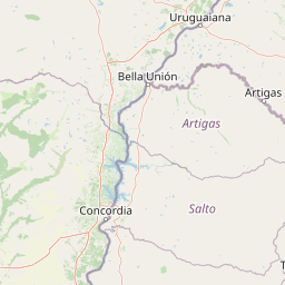
Map view of Rincón de Franquía Habitat and Species Management Area

Use this park location map to pinpoint Rincón de Franquía Habitat and Species Management Area in Uruguay, understand its exact geographic position, and read its mapped placement within the surrounding landscape more clearly.

Pigeon | © OpenStreetMap contributors

Location context for Rincón de Franquía Habitat and Species Management Area

Artigas Department

Visual reference of riverine forests, floodplain mosaics, and borderland wetland habitats

Área de manejo de hábitats y/o especies Rincón de Franquía Photos and Landscapes

Visual documentation of Área de manejo de hábitats y/o especies Rincón de Franquía reveals the intricate mosaic of riverine forests, seasonal wetlands, and floodplain terrain shaping the reserve. Photographic records provide clear insight into the ecological character of this protected area and its dynamic riparian environment.

A tall, multi-level wooden observation tower with a staircase stands in an open grassy area with trees and a clear blue sky in the background.

A wide, unpaved dirt road or trail leads into the distance, flanked by dense low-lying trees and shrubs on both sides under a clear blue sky.

Park atlas

Compare adjacent protected landscapes and riverine reserves in the regional borderlands

Parks near Área de manejo de hábitats y/o especies Rincón de Franquía

Browse other protected areas near Área de manejo de hábitats y/o especies Rincón de Franquía to compare contiguous riverine forests and wetland habitats. Examining regional park geography provides broader context for transboundary conservation networks across the triple frontier.
A horizontal watercolor illustration of a wetland scene with soft green marsh vegetation in the foreground, rolling green hills in the midground, and faint mountains in the soft yellow background.
Nature reserveCorrientes Province
About 178 km away#1 closest

North

Iberá Provincial Reserve: Atlas and Geographic Overview of Corrientes Province Wetlands

Protected freshwater landscapes and shifting lagoon systems in northeastern Argentina.

Iberá Provincial Reserve provides a unique case study in wetland recovery and conservation, stretching across a vast mosaic of permanent lagoons, sloughs, and flooded plains. Gain insight into the park boundaries and the complex subtropical landscape of northeastern Argentina through this structured geographic entry. Understand the spatial relationship between the provincial reserve, protected park units, and the surrounding environment.

Area
13,000 km²
Established
1983
IUCN
VI
Relief
Lowland
National parkEntre Ríos Province
About 189 km away#2 closest

South

El Palmar National Park: Protected Area Atlas and Geographic Exploration in Entre Ríos

Discover mapped park boundaries and regional landscape context.

El Palmar National Park offers a dedicated space for understanding protected landscapes within Argentina. As a designated national park situated in Entre Ríos Province, it serves as a crucial point for exploring mapped natural terrain and regional geography. This entry provides specific details on its protected area status and its contribution to the broader atlas of conservation lands in the Mesopotamia region.

Area
85 km²
Established
1966
IUCN
II
Access
Easy access
Protected landscapeRivera
About 197 km away#3 closest

Southeast

Valle del Lunarejo Protected Landscape: Mapped Geography and Terrain in Rivera, Uruguay

A rugged river valley protected area in the Uruguayan north.

Valle del Lunarejo represents a unique geological contact zone in Rivera, Uruguay, characterized by dramatic basaltic cliffs, dense gallery forests, and a network of stream-fed waterfalls. This protected landscape offers a detailed look at the interplay between Mesozoic volcanic flows and sandstone deposits, shaping a distinct terrain that diverges from the surrounding plains. The area provides essential context for understanding northern Uruguayan topography and the distribution of diverse habitats within the National System of Protected Areas.

Area
292.86 km²
Established
2001
Relief
Mixed relief
Climate
Subtropical
A horizontal watercolor painting depicting a meandering river flowing through a green, hilly landscape with trees and soft, pastel lighting.
Protected areaPaysandú
About 217 km away#4 closest

South

Área protegida con recursos manejados Montes del Queguay: Geography and Protected Boundaries

Managed-resource landscape in the Paysandú river network

This protected area centers on a distinct floodplain basin in Paysandú, where silty soils and river confluence dynamics support a unique mosaic of riparian forest and wetland terrain. Explore the structural geography of this significant native woodland complex and its role within Uruguay's protected land system.

Area
434.1 km²
Established
1994
Relief
Lowland
Climate
Subtropical
National parkCorrientes Province
About 233 km away#5 closest

North

Iberá National Park: National Park Atlas Exploration in Corrientes Province

Mapped protected area context and regional geography.

Delve into the atlas view of Iberá National Park, a designated national park situated in Corrientes Province, Argentina. This detailed entry clarifies the park's protected landscape identity and its contribution to the regional geography of northeastern Argentina. Understand its mapped boundaries and explore its significance as a conservation area within the Mesopotamia region.

Area
1,835 km²
Established
2018
IUCN
II
Relief
Lowland
National parkCorrientes Province
About 237 km away#6 closest

North

Mburucuyá National Park: National Park in Corrientes Province, Argentina

Iconic yatay palm savannas and diverse wetland ecosystems.

As a key national park within Argentina's Corrientes Province, Mburucuyá National Park offers a unique atlas-scale view of ecological convergence. It preserves expansive yatay palm savannas, critical wetland habitats within the Iberá Wetlands, and lush subtropical forests. The park's boundaries define an area where the Humid Chaco, Espinal, and Selva Paranaense biomes meet, creating a landscape of exceptional biodiversity and geographic significance for regional conservation and mapped exploration.

Area
176.82 km²
Established
2001
IUCN
II
Relief
Lowland
A soft, light-toned watercolor illustration of a river landscape with low green islands and marshy vegetation under a pale, minimalist sky.
National parkRío Negro Department
About 273 km away#7 closest

South

Parque nacional Esteros de Farrapos e Islas del Río Uruguay: Protected Wetland Geography

Exploring the fluvial island and riverine terrain of Río Negro

This protected area represents an essential riverine ecosystem along the western frontier of Uruguay. The landscape comprises a complex layering of flood-prone plains, riparian forest edges, and silty soil formations that characterize the regional geography of the Río Uruguay basin.

Area
215.65 km²
Established
2008
Relief
Lowland
Scope
Terrestrial
Wildlife reserveRío Negro Department
About 301 km away#8 closest

South

Área de manejo de hábitats y/o especies Esteros y Algarrobales del Río Uruguay Protected Area Geography

Wildlife reserve in the Río Negro department with unique riparian corridors.

This wildlife reserve protects a unique transition zone where dry-forest Prosopis woodlands thrive alongside wetland esteros. Its mapped terrain reflects the intersection of two distinct ecoregions, creating a fragile landscape characterized by blanqueales soils, gallery forests, and river-fed floodplains within a larger protected conservation mosaic.

Area
15.5 km²
Relief
Lowland
Scope
Terrestrial
Water
Major water bodies

Common questions about visiting, size, designation, and location context for Rincón de Franquía Habitat and Species Management Area

Rincón de Franquía Habitat and Species Management Area FAQs for park facts, access, geography, and protected area context

Find quick answers about Rincón de Franquía Habitat and Species Management Area, including protected-area facts, park geography, trail and visitor context, and how the park fits into its surrounding country and regional landscape.
MoriAtlas Explorer

Continue Your Protected Areas Search Across the Global Atlas

Deepen your exploration by continuing the structured search for national parks and protected areas worldwide. Utilize the comprehensive filtering capabilities to compare different conservation landscapes and refine your understanding of global park geography. Discover more about the distribution and characteristics of protected natural areas.

Global natural geography