

Mori Atlas logo
National parkRio Abiseo National Park

Discover the geographic boundaries and atlas context of this vital national park.

Rio Abiseo National Park: Peru's Protected Landscape in the San Martín Region

Rio Abiseo National Park represents a significant protected natural area within Peru's San Martín Region. This page provides detailed geographic context and atlas exploration tools, enabling a deep understanding of the park's protected landscape identity and its mapped boundaries. Delve into the regional setting and discover the atlas-driven value of this protected territory.

UNESCO World Heritage SiteCloud ForestPre-Columbian ArchaeologyChachapoyas CultureCritical HabitatAndean Mountains

Rio Abiseo National Park

National park

Park overview

Structured park overview, official facts, and landscape profile for Rio Abiseo National Park

Rio Abiseo National Park park facts, protected area profile, and essential visitor context
Review the core facts for Rio Abiseo National Park, including designation, size, terrain, visitor scale, habitats, and operating context in one park-focused overview.

About Rio Abiseo National Park

Rio Abiseo National Park represents one of the most significant protected areas in Peru, distinguished by its remarkable ecological diversity and extraordinary archaeological heritage. The park sits within a mountainous landscape of exceptional complexity, where deep river canyons, steep forested slopes, and high alpine meadows create a tapestry of distinct environments. The region lies at the crossroads of multiple biogeographic zones, allowing species from distant ecosystems to coexist within the same protected landscape. What makes Rio Abiseo particularly remarkable is the unprecedented decision to close the park to tourism entirely since 1986, a measure taken to preserve both its fragile natural ecosystems and the numerous archaeological sites that remain vulnerable to disturbance. This policy reflects the park's dual identity as both a sanctuary for biodiversity and a repository of pre-Columbian cultural heritage. The park's World Heritage status acknowledges that its significance transcends national boundaries, representing a legacy of importance to all of humanity.

Quick facts and research context for Rio Abiseo National Park

Rio Abiseo National Park is located in the San Martín Department of Peru, occupying roughly 70% of the Abiseo River basin. Elevations within the park range from 350 meters in the lower valleys to 4,200 meters at the highest peaks. The protected area maintains seven distinct climate zones, with the montane cloud forest dominating most of the park above 2,300 meters. The park was inscribed on the UNESCO World Heritage List in 1990 under mixed criteria recognizing both natural and cultural significance, making it one of the few protected areas in the Americas with such dual recognition. Access has been restricted since 1986 to protect both the natural environment and the numerous archaeological sites scattered throughout the terrain.

Park context

Deeper park guide and search-rich context for Rio Abiseo National Park

Rio Abiseo National Park history, landscape, wildlife, and travel context
Explore Rio Abiseo National Park through its history, landscape character, ecosystems, wildlife, conservation priorities, cultural context, and seasonal travel timing in a structured park guide built for atlas discovery and search intent.

Why Rio Abiseo National Park stands out

Rio Abiseo National Park is most renowned for two interconnected distinctions. First, it harbors the critically endangered yellow-tailed woolly monkey (Oreonax flavicauda), a primate species once thought extinct that is now known to be endemic to this region and was the primary catalyst for the park's establishment. Second, the park contains over 30 pre-Columbian archaeological sites, with the most significant being Gran Pajatén, a fortified settlement of the mysterious Chachapoyas culture perched on a forested ridge above the Montecristo River canyon. This combination of irreplaceable ecological and cultural heritage distinguishes the park from most other protected areas in South America.

Rio Abiseo National Park history and protected-area timeline

Rio Abiseo National Park was established on August 11, 1983, through governmental decree 064-83-AG, primarily in response to the rediscovery of the yellow-tailed woolly monkey, a species previously believed to be extinct that was found to survive in the park's montane forests. The park's extraordinary archaeological significance became apparent during subsequent research expeditions, leading to its inscription on the UNESCO World Heritage List in 1990 under mixed criteria recognizing both natural and cultural heritage. An extension was added in 1992, further expanding the protected zone. The most extensive archaeological research in the park was conducted by the University of Colorado at Boulder during the mid-1980s, which documented the extent of Chachapoyas settlements across the region. Following the discovery of major archaeological sites including Gran Pajatén and the cliff tombs of Los Pinchudos, authorities determined that the park's twin heritage could not sustain the pressures of tourism, leading to the closure of the park to visitors in 1986. This remains one of the few complete tourism prohibitions implemented for a World Heritage Site.

Rio Abiseo National Park landscape and geographic character

The physical landscape of Rio Abiseo National Park is characterized by dramatic topographical relief resulting from its position in the central Peruvian Andes. The terrain is dominated by steep-walled river valleys carved by the Abiseo River and its tributaries, with the Montecristo River canyon providing particularly spectacular scenery. Elevations span from 350 meters in the lower river valleys to 4,200 meters in the highest reaches, creating dramatic changes in landscape character across relatively short distances. The park protects approximately 70% of the Abiseo River basin, with the river itself cutting through the heart of the protected area. Seven distinct climate zones occur within the park's boundaries, including montane forest, tropical alpine forest, montane rainforest, high Andean grasslands known as puna, and dry forest at lower elevations. The montane cloud forest, which covers the majority of the park above 2,300 meters, features short trees enveloped in moss and lichen, creating an otherworldly atmosphere where high humidity and year-round precipitation sustain constant moisture.

Rio Abiseo National Park ecosystems, habitats, and plant life

The ecological character of Rio Abiseo National Park is defined by the convergence of three distinct ecoregions within its boundaries. At lower elevations, the Ucayali moist forests support diverse tropical species in relatively accessible lowland terrain. The Peruvian Yungas occupy the middle elevation zones, providing critical habitat for numerous endemic species in these cloud-shrouded montane forests. At the highest elevations, the Cordillera Central páramo creates a unique alpine environment with distinctive vegetation adapted to cool, wet conditions. The montane cloud forest represents the dominant ecosystem, a high-altitude rainforest where constant humidity, frequent fog, and acidic soils support specialized plant communities. Rainfall throughout the park ranges from approximately 500 to 2,000 millimeters annually, with precipitation greatest at higher elevations. The park documents over 5,000 plant species in total, with 980 species recorded in the highland zones alone, including 13 endemic species found nowhere else on Earth.

Rio Abiseo National Park wildlife and species highlights

Rio Abiseo National Park supports an extraordinary concentration of wildlife, with several species of particular conservation significance. The park is most famous for the yellow-tailed woolly monkey (Oreonax flavicauda), a primate once presumed extinct that was rediscovered in the region and is now known to be endemic to this area. This critically endangered species was the primary reason for the park's establishment and remains a flagship for conservation efforts. The mammalian fauna includes the vulnerable white-fronted spider monkey, the endangered Peruvian guemal (a rare deer species), the endangered mountain paca, and the endangered spectacled bear, South America's only bear species. Large predators are represented by the jaguar, while the king vulture and turkey vulture dominate the scavenging bird community. The park supports at least 18 documented bird species of conservation concern, including the endangered Russet-mantled softtail and the endangered yellow-browed toucanet. This combination of endemic primates, rare ungulates, and significant birdlife makes the park exceptionally important for Neotropical biodiversity.

Rio Abiseo National Park conservation status and protection priorities

Rio Abiseo National Park represents a model of strict protection for areas of exceptional combined natural and cultural significance. The park's UNESCO World Heritage designation acknowledges that its value extends beyond national importance to universal significance for humanity. The decision to prohibit tourism entirely since 1986 demonstrates an unusual commitment to preservation over access, recognizing that the park's archaeological sites and ecological communities cannot sustain regular visitor impacts. The presence of the critically endangered yellow-tailed woolly monkey was the primary catalyst for national park status, and ongoing conservation efforts focus on protecting this species and its habitat. The park's management under SERNANP (Peru's National Service of Protected Areas) works to balance research access with the imperative to preserve both natural and cultural heritage. The three protected ecoregions within the park represent significant conservation priorities at the global scale, with the cloud forest ecosystem being particularly important for carbon storage, water regulation, and biodiversity preservation.

Rio Abiseo National Park cultural meaning and human context

The archaeological significance of Rio Abiseo National Park is extraordinary, with over 30 pre-Columbian sites documented within its boundaries. The most prominent is Gran Pajatén, a fortified settlement perched on a forested ridge overlooking the Montecristo River canyon, featuring structures attributed to the Chachapoyas civilization. The Chachapoyas, often called the Warriors of the Clouds, inhabited this region before Inca conquest and left behind a remarkable legacy of architecture, including cliff tombs at the site known as Los Pinchudos. These cliff tombs, discovered by local villagers in the early 1970s, represent mortuary practices unique to this culture. The University of Colorado's research during the 1980s documented the extent of this ancient settlement pattern, revealing that the park contains one of the most significant concentrations of pre-Columbian archaeology in Peru. The cultural landscape reflects a civilization that adapted to the challenging mountain environment while maintaining connections to broader Andean cultural networks.

Top sights and standout views in Rio Abiseo National Park

Rio Abiseo National Park stands among the world's most significant protected areas due to its dual World Heritage status recognizing both natural and cultural significance. The critically endangered yellow-tailed woolly monkey, once thought extinct, survives here as the park's most iconic species. The Chachapoyas archaeological sites, particularly Gran Pajatén, represent a pre-Columbian civilization of remarkable sophistication. The park protects three complete ecoregions in a vertical gradient from 350 to 4,200 meters, creating extraordinary ecological diversity within a single protected area. The complete closure to tourism since 1986 reflects an unprecedented commitment to preserving this irreplaceable heritage for future generations rather than exploiting it for present-day recreation.

Best time to visit Rio Abiseo National Park

As a park that has been closed to tourism since 1986, Rio Abiseo National Park does not receive general visitors. For the rare research expeditions granted access, the dry season from May through September typically offers more stable conditions for field work, though the montane cloud forest experiences rainfall throughout the year. The high-altitude páramo zones experience cooler temperatures year-round, while the lower elevations maintain warmer conditions. The constant humidity of the cloud forest means that any season involves wet conditions, with research activities typically planned around the relatively drier months of the mid-year period.

Park location guide

Geography guide, regional context, and park location map for Rio Abiseo National Park

Rio Abiseo National Park park geography, regions, and map view in Peru
Understand where Rio Abiseo National Park sits in Peru through a broader geographic reading of the surrounding landscape, nearby location context, and its mapped position within the national park landscape.

How Rio Abiseo National Park fits into Peru

Peru is a megadiverse country in western South America with a population of over 34 million. It spans three distinct geographic regions: the Pacific coastal desert in the west, the Andes mountains running north to south, and the Amazon rainforest in the east. The country has one of the longest histories of civilization in the world, tracing back to the Caral-Supe civilization of the 10th millennium BCE, and was home to the Inca Empire before Spanish colonization in the 16th century.

Wider geography shaping Rio Abiseo National Park in Peru

Peru is located in western South America along the Pacific coast. The country encompasses three major geographic regions: the coastal desert plains along the Pacific, the Andes mountain range extending from north to southeast, and the Amazon basin rainforest in the eastern interior. It shares borders with Ecuador and Colombia to the north, Brazil to the east, Bolivia to the southeast, and Chile to the south.

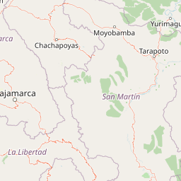
Map view of Rio Abiseo National Park

Use this park location map to pinpoint Rio Abiseo National Park in Peru, understand its exact geographic position, and read its mapped placement within the surrounding landscape more clearly.

Pigeon | © OpenStreetMap contributors

Location context for Rio Abiseo National Park

Huicungo DistrictSan Martín Region
Park atlas

Compare other protected areas, tracing their geographic context across the Peruvian Andes.

Discover Related National Parks and Protected Areas Near Rio Abiseo National Park
After exploring Rio Abiseo National Park, you can browse a curated list of nearby national parks and other protected areas, identifying their positions within the diverse Andean terrain of Peru. Continue your geographic discovery by comparing regional conservation landscapes and understanding the wider spread of protected zones beyond Rio Abiseo, a critical UNESCO World Heritage site.
National parkPeru

Cordillera Azul National Park: A National Park for Geographic Discovery in Peru

Explore Peru's protected landscape and regional map context.

Cordillera Azul National Park serves as a dedicated entry point for understanding Peru's protected natural areas through a geographic lens. This park's identity is tied to its specific mapped boundaries and its contribution to the nation's diverse terrain. Focusing on Cordillera Azul National Park allows for detailed atlas exploration of its unique landscape context within western South America, providing factual data for geographic understanding.

Area
13,531.9 km²
Established
2001
IUCN
II
Relief
Mountain
National parkAncash

Huascarán National Park: Protected Landscape and Regional Geography in Ancash, Peru

Explore the mapped boundaries of this significant national park.

Huascarán National Park is a protected national park located in the Ancash region of Peru, offering valuable insights for geographic and atlas exploration. This destination provides detailed information on the park's mapped boundaries, its designation as a national park, and its integration into the regional geography. Understanding Huascarán National Park helps contextualize protected land distribution and landscape features within Peru for those interested in structured geographic discovery and atlas-style mapping.

Area
3,400 km²
Established
1975
IUCN
II
Relief
Mountain
National parkHuánuco Region

Tingo María National Park: National Park Protected Landscape in Huánuco Region, Peru

Atlas exploration of park boundaries and regional geography.

Investigate Tingo María National Park, a key protected area situated in the Huánuco Region of Peru. This national park designation signifies its importance for understanding the country's natural landscapes and mapped geography. Explore its protected territory and discover its place within the regional atlas.

Area
47.778 km²
Established
1965
IUCN
II
Relief
Mountain
National parkCajamarca Region

Cutervo National Park: Peru's Oldest National Park Atlas and Protected Landscape

Andean Montane Forests and Mapped Geography of a Pioneering Protected Area

As Peru's oldest national park, established in 1961, Cutervo National Park offers a unique glimpse into the protected geography of the northern Peruvian Andes. Located in the Cajamarca Region, it preserves diverse Andean montane forests and páramo grasslands across a significant elevation gradient from 1,550 to 3,500 meters. This page details the park's landscape, including its role as a headwater conservation area and its position within a critical South American ecoregion, providing rich context for geographic and protected-area exploration.

Area
82.14 km²
Established
1961
IUCN
II
Relief
Mountain
National parkPeru

Sierra del Divisor National Park: Peru's Sacred Amazonian Protected Landmark

Explore dramatic mountain terrain and protected lowland rainforest.

Sierra del Divisor National Park in Peru is a vital protected area conserving over 1.35 million hectares of Amazon rainforest. Characterized by the unique Sierra del Divisor mountain range and the sacred pyramid peak of Cerro El Cono, the park offers a distinct landscape within the broader Amazon basin. As one of Peru's newer national parks, it represents a significant commitment to preserving critical biodiversity corridors and understanding the geographic context of protected lands in a region facing environmental pressures.

Area
13,544.8 km²
Established
2015
IUCN
II
Relief
Mixed relief
National parkPasco Region

Yanachaga, Chemillén National Park: Protected Area in Pasco Region, Peru

Mapped terrain, Pleistocene refuge, and rich biodiversity.

Yanachaga, Chemillén National Park, a national park situated in Peru's Pasco Region, preserves over 122,000 hectares of mountainous cloud forest and rainforest ecosystems. Its landscape is characterized by dramatic canyons and steep forested slopes, creating significant altitudinal variation from 460 to 3,643 meters. Recognized as a Pleistocene refuge, the park shelters ancient forest remnants and harbors exceptional biodiversity, including hundreds of bird species and iconic mammals, offering rich context for geographic and protected-area exploration.

Area
1,220 km²
Established
1986
IUCN
II
Relief
Mountain
National parkZamora Chinchipe

Yacurí National Park: Protected Andean Lakes and Volcanic Landscape in Zamora Chinchipe

Discover highland geography and the ancient Inca Trail.

Yacurí National Park is a key protected landscape in Ecuador's southern Andes, celebrated for its remarkable collection of over 46 high-altitude lakes set within dramatic volcanic terrain. Situated in Zamora Chinchipe province, the park preserves a vital stretch of the Inca Trail, complete with archaeological sites. This national park offers a rich exploration of Andean geography, páramo ecosystems, and significant cultural heritage, making it a cornerstone of the region's protected areas.

Area
431 km²
Established
2009
IUCN
II
Relief
Mountain
National parkEcuador

Podocarpus National Park: Ecuador's Diverse National Park and Protected Landscape

Discover elfin forests, paramo, and over 100 lagoons.

Podocarpus National Park, situated in southeastern Ecuador, stands as a prime example of a protected natural area at a unique biogeographic crossroads. This national park spans dramatic elevational zones, from montane rain forests to high-elevation paramo ecosystems dotted with more than 100 lagoons, offering rich mapped landscape exploration. Its significance lies in the convergence of four distinct ecological systems, contributing to exceptional biodiversity and a rich tapestry of natural terrain.

Area
1,462.8 km²
Established
1982
IUCN
II
Relief
Mountain

Common questions about visiting, size, designation, and location context for Rio Abiseo National Park

Rio Abiseo National Park FAQs for park facts, access, geography, and protected area context
Find quick answers about Rio Abiseo National Park, including protected-area facts, park geography, trail and visitor context, and how the park fits into its surrounding country and regional landscape.
MoriAtlas Explorer

Continue Your Protected Areas Search Across the Global Atlas

Deepen your exploration by continuing the structured search for national parks and protected areas worldwide. Utilize the comprehensive filtering capabilities to compare different conservation landscapes and refine your understanding of global park geography. Discover more about the distribution and characteristics of protected natural areas.

Global natural geography