Mori Atlas logo
Nature reserveRiserva naturale Valle Bova

Mapping the stream-carved valley, historic hiking routes, and karst features of the Lombardy region

Riserva naturale Valle Bova: A Protected Geological Landscape in the Italian Pre-Alps

Riserva naturale Valle Bova encompasses 391 hectares of protected forest and river valley within the Triangolo Lariano of Northern Italy. This nature reserve serves as a vital geographic anchor for the Bova stream, which flows through a rugged ravine marked by deep gorges, karst cave systems, and steep wooded slopes. The terrain connects the municipal landscape of Erba to high-elevation pre-Alpine ridges, offering a detailed study of how riparian habitats transition into mountain ecosystems.

nature reservebroadleaf forestpre-Alpsriver valleykarst cavegorge

Riserva naturale Valle Bova

Nature reserve

Park overview

Structured park overview, official facts, and landscape profile for Riserva naturale Valle Bova

Riserva naturale Valle Bova park facts, protected area profile, and essential visitor context

Review the core facts for Riserva naturale Valle Bova, including designation, size, terrain, visitor scale, habitats, and operating context in one park-focused overview.

About Riserva naturale Valle Bova

Riserva naturale Valle Bova is a small but atmospherically distinctive regional nature reserve in Lombardy, occupying the valley floor and slopes above the Bova stream within the municipality of Erba. The reserve is part of the broader environmental mosaic at the foot of the Triangolo Lariano, the triangular mass of pre-Alpine terrain that separates the two southern arms of Lake Como. From this position the reserve links the lower, more populated Como basin with the wooded ridges and peaks that rise toward Corni di Canzo, Monte Palanzone, and the wider Lariano trail system.

The valley itself is shaped by the Bova stream, which originates at the Orrido di Caino, runs through the entire length of the protected area, and ultimately flows into the Lambro river. The terrain inside the reserve is varied in a compact way: lowland and gently sloping stretches dominate the main valley trail, while the edges rise steeply where creeks descend from the surrounding peaks. Trails like the Iron Stair and the wooden stairway to Salute give access to exposed sections along cliffs and gorges, with rope-assisted sections reserved for experienced hikers.

Ecologically, the reserve is characterized by extensive broadleaf woodland. Birch, oak, beech, and chestnut are the principal tree species, and the autumn season is noted locally for its mushroom abundance while summer brings a varied display of wildflowers. The reserve's river and stream habitat supports fish populations such as chub, trout, and pike, and is also home to amphibian species including the fire salamander. Birdlife is diverse across the valley, with raptors such as falcons among the species recorded in the area.

Culturally and historically, the valley has long functioned as a recreational outlet for the surrounding communities. Trails lead to features such as the medieval Hermitage of San Salvatore, the Croce Pessina summit with its cross and bell installed in the 1980s by the residents of Crevenna, and the Capanna Mara hut, a gathering point for hikers crossing the Triangolo Lariano at roughly 1,000 meters elevation. The reserve thus combines ecological protection, geological heritage, and a long tradition of local outdoor use into a compact, easily accessible protected landscape.

Quick facts and research context for Riserva naturale Valle Bova

Riserva naturale Valle Bova is a regional nature reserve in Lombardy, northern Italy, covering about 391 hectares within the municipality of Erba in the Province of Como. The reserve is classified under the Italian official protected-area system as EUAP1208 and is recognized internationally as an IUCN Category IV protected area, focused on the conservation of specific habitats and species.

It was formally established by Regional Council Decree 438 on 25 September 2007 and is administered by the Comune di Erba. The reserve takes its name from the Bova stream, which flows through the entire valley and joins the Lambro river downstream. The area sits at the foot of the Triangolo Lariano, the pre-Alpine ridge between the two branches of Lake Como, and connects to a wider network of mountain trails across the local hills.

Protection and recognition

Documented terrestrial protection scope, management details, and recognition data

Riserva Naturale Valle Bova Protection Status and Designated Area Record

Riserva naturale Valle Bova maintains a documented terrestrial protection scope cataloged within global conservation databases. Verified administrative records outline the official protected area designation and management parameters for public reference.

Protection details

Protection scope
Terrestrial
Transboundary protection
No
WDPA ID
390461
Park context

Deeper park guide and search-rich context for Riserva naturale Valle Bova

Riserva naturale Valle Bova history, landscape, wildlife, and travel context

Explore Riserva naturale Valle Bova through its history, landscape character, ecosystems, wildlife, conservation priorities, cultural context, and seasonal travel timing in a structured park guide built for atlas discovery and search intent.

Why Riserva naturale Valle Bova stands out

The reserve is most strongly associated with two dramatic natural landmarks: the Buco del Piombo and the Orrido di Caino. The Buco del Piombo is a cave of unusually large dimensions that has attracted visitors to the valley for a very long time and remains the single most recognizable feature of the area. The Orrido di Caino, by contrast, is a narrow cleft formed between two enormous boulders near the upper end of the reserve, marking the source of the Bova stream. Together with the scarred river gorge, the wooden footbridge (Ponte di Legno), the historic Iron Stair (Scala di Ferro), and the wooden three-ramp stairway (Scala di Legno), these elements give the valley its strongly geological and almost adventurous character rather than a purely scenic or panoramic one.
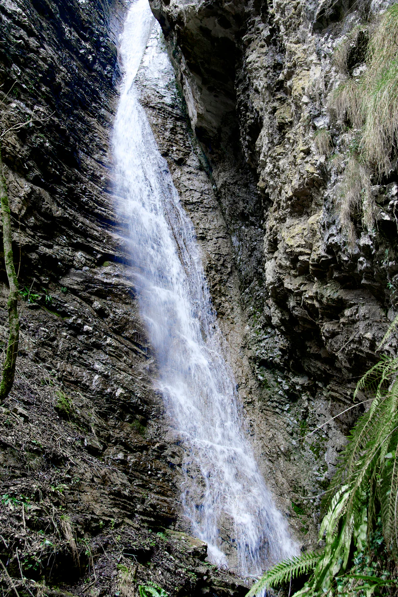
A narrow waterfall cascading down a sheer, rocky gorge wall in a narrow canyon.
Waterfall on Bova Creek within the Orrido di Caino gorge.

Riserva naturale Valle Bova history and protected-area timeline

The Riserva naturale Valle Bova was formally established on 25 September 2007 through Regional Council Decree 438 (DCR 438 25/09/07), making it a relatively recent addition to Lombardy's regional network of protected areas. From its inception, management of the reserve has been entrusted to the Comune di Erba, reflecting the fact that the entire protected area lies within the municipal territory of Erba.

Although the reserve itself is modern, the valley it protects has a much longer history of human attention. The Buco del Piombo, the cave that anchors the valley's identity, was already being visited and depicted well before the reserve existed, as evidenced by mid-twentieth-century postcards showing the cave. Trails linking the valley to surrounding hamlets, hermitages, and mountain passes, including the long-standing route toward Capanna Mara and the Triangolo Lariano summits, also predate the reserve's official designation and reflect traditional patterns of local hiking and pilgrimage.

The 2007 decree brought these existing values together under a single protection framework, formalizing the area's status as habitat and species conservation land under the Italian EUAP system and the international IUCN framework, with management coordinated by the local municipality.

Riserva naturale Valle Bova landscape and geographic character

The landscape of Riserva naturale Valle Bova is defined by a relatively narrow, elongated valley carved by the Bova stream, with steeply rising wooded slopes on either side. The reserve begins near Crevenna, a frazione of Erba, where the valley opens gradually, and extends upstream toward the Orrido di Caino, a dramatic narrow fissure between two large boulders that marks the source of the Bova and effectively forms the upper visible boundary of the protected core.

The valley floor is shaped by the meandering course of the Bova and is crossed by footbridges and small bridges such as the Ponte di Legno, which connects the two banks above a deep pool. Outside the central axis, the terrain rises rapidly toward surrounding peaks, with cliffs and ridges that fall abruptly to the stream in places. The exposed character of these slopes gives the reserve a notably rugged feel for its modest size, and is the reason why the main access routes to higher features, including the Scala di Ferro and Scala di Legno, require proper equipment and are considered suitable only for experienced hikers.

Beyond the valley itself, the landscape opens onto wider views toward Albavilla and the pre-Alpine ridges that form the spine of the Triangolo Lariano. From the trail network it is possible to reach the Croce Pessina summit, the Salute locality above Albavilla, and the Capanna Mara refuge near 1,000 meters elevation, providing transition from the dense, sheltered forest of the protected valley to the more open mountain environment that surrounds it.
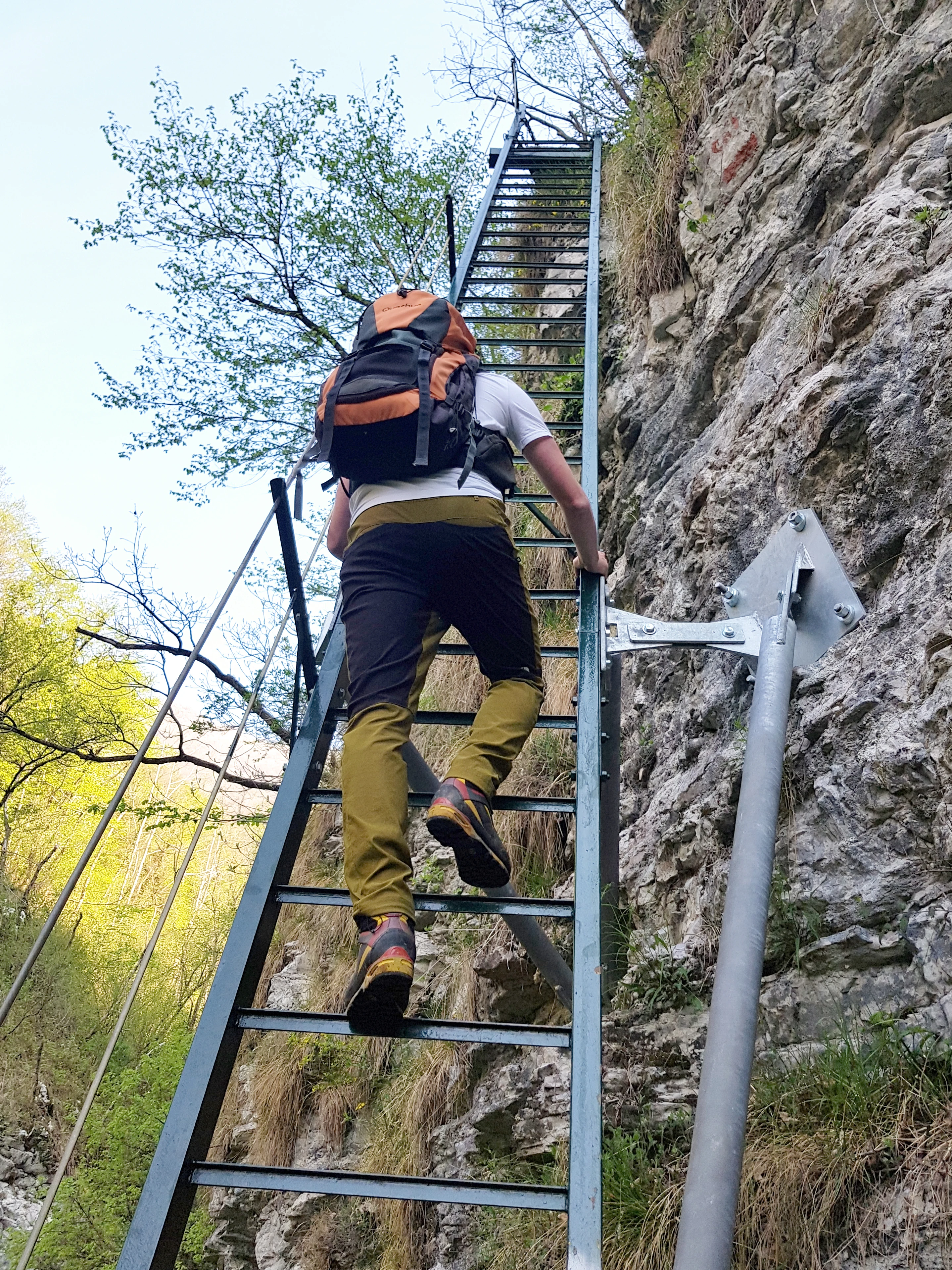
A hiker with a backpack climbing a steep, narrow metal ladder attached to a rocky cliff face on a trail.
A hiker ascends the Scala di Ferro metal staircase trail in Riserva naturale Valle Bova.

Riserva naturale Valle Bova ecosystems, habitats, and plant life

Ecologically, Riserva naturale Valle Bova is dominated by well-developed broadleaf forest, a vegetation pattern that gives the protected area its characteristically enclosed, sheltered feel. Birch, oak, and beech are the most prominent tree species across the slopes, with chestnut trees as a persistent presence, reflecting the long historical role of chestnut cultivation in the lower hills of the Como basin.

Along the valley floor, the stream and its corridors create a distinct riparian microclimate, supporting mosses, ferns, and a rich layer of leaf litter that sustains both the forest floor habitat and the aquatic fauna. In autumn the reserve is known locally for its abundance of mushrooms, while summer brings a varied flowering of native wildflowers along the trail and in clearings, contributing seasonal color to the woodland.

The reserve's habitat mosaic, combining shaded deciduous forest, exposed rocky cliffs, the stream system, and small wetland pockets around pools like the one beneath the Ponte di Legno, supports a notable ecological range within a relatively compact area. This combination of forest, gorge, and watercourse is the basis for the reserve's classification as an IUCN Category IV area focused on the conservation of habitats and species.

Riserva naturale Valle Bova wildlife and species highlights

Wildlife in Riserva naturale Valle Bova reflects the composition typical of well-preserved broadleaf valleys in the Lombard pre-Alps. Birdlife is one of the most visible elements of the fauna, with a wide variety of bird species present throughout the reserve and raptors such as falcons noted among them.

The stream system of the Bova supports a richer aquatic community than might be expected for a valley of this size, with fish such as chub, brown trout, and pike present in the waters. Where the stream slows and pools form, amphibians find suitable habitat, and the fire salamander is among the amphibian species reported in the reserve. The fallen deadwood, leaf litter, and damp rock crevices typical of the valley's forest floor provide shelter for invertebrates, reptiles, and small mammals, completing a typical, if not spectacular, pre-Alpine animal community.

Overall, while the reserve does not host charismatic megafauna, its combination of forest, gorge, and stream provides a coherent habitat complex that supports a representative cross-section of ordinary woodland, riparian, and cliff-dwelling species of the Lombard pre-Alps.

Riserva naturale Valle Bova conservation status and protection priorities

Riserva naturale Valle Bova is established under Italy's regional system of protected natural areas and is recorded under the official EUAP code EUAP1208. Internationally it falls within IUCN Category IV, a designation applied to areas whose primary purpose is the conservation of particular habitats or species, often through managed intervention rather than strict wilderness protection. The reserve's management is delegated to the Comune di Erba, integrating conservation objectives with the practical involvement of the local municipality.

In conservation terms, the reserve's significance lies less in extreme rarity and more in the protection of an intact, contiguous example of pre-Alpine broadleaf valley ecosystem, including its forest composition, gorge habitats, and stream corridor. By formalizing protection over the Bova valley and its tributary slopes, the reserve contributes to regional efforts to maintain ecological connectivity between the lowland Como basin and the higher ridges of the Triangolo Lariano, including the trail and habitat network that extends toward Croce Pessina, Capanna Mara, and Monte Palanzone.

The combination of habitat, geological features such as the Buco del Piombo and the Orrido di Caino, and traditional trail infrastructure also makes the reserve a focal point for environmental education and low-impact recreation in the Erba area.

Riserva naturale Valle Bova cultural meaning and human context

The valley has long been part of the everyday recreational and spiritual landscape of the communities around Erba. Trails leading out of the valley carry visitors to the medieval Hermitage of San Salvatore, suggesting a centuries-old pattern of religious and contemplative use of these slopes. At Croce Pessina, a summit cross and bell installed by the residents of Crevenna in the 1980s continue to mark the mountain's role as a focal point for community life, with a traditional gathering for the feast of Santa Maria Maddalena each July.

The reserve also sits within a broader local hiking culture organized around the Triangolo Lariano, with the Capanna Mara refuge serving as a traditional crossroads for walkers moving between Erba, Albavilla, and the surrounding peaks. The valley's accessibility from Erba has shaped its identity as a nearby natural escape for residents of the Como basin, while sites such as the Buco del Piombo were already part of regional tourism well before the formal establishment of the reserve.

Top sights and standout views in Riserva naturale Valle Bova

Despite its modest size, Riserva naturale Valle Bova packs an unusual concentration of distinct features into a single valley. The Buco del Piombo is the headline attraction, drawing visitors interested in karst and cave features, while the Orrido di Caino offers a tightly compressed gorge landscape unusual for this part of Lombardy.

The reserve's trail network further enriches its profile: the Iron Stair and the wooden stairway to Salute add elements of engineered, historic path-building; the Ponte di Legno crossing frames the Bova stream; and connections toward Capanna Mara and Croce Pessina extend the protected valley into the wider pre-Alpine landscape. Together they give the reserve a layered identity that combines cave geology, gorge scenery, broadleaf forest, and traditional hiking heritage.

Best time to visit Riserva naturale Valle Bova

The reserve's seasonal character shifts with the woodland calendar. Spring and early summer bring active stream flow, fresh green foliage, and increasingly visible wildflowers along the trails, with longer daylight hours making it easier to combine a valley walk with an ascent toward the surrounding trails.

Autumn is locally regarded as a particularly rewarding time, when mushroom foraging becomes a recurring activity in the broadleaf forest and the beech, oak, chestnut, and birch trees turn. Winter visits are possible but bring reduced trail comfort, exposed conditions along the gorge sections, and the practical reality that the more demanding routes such as Scala di Legno toward Salute should only be attempted by experienced, properly equipped hikers in any season.

Monthly climate preview

Measured monthly temperature ranges and precipitation patterns across representative coordinates

Riserva naturale Valle Bova Climate Normals and Average Temperature Profiles

Long-term NASA Power records from 1991 to 2020 document measured monthly temperature variations and precipitation levels at a representative coordinate within Riserva naturale Valle Bova. Examining the complete twelve-month profile provides detailed meteorological context for studying annual thermal rhythms and moisture distribution across the protected area.
Annual mean8 °C
-2 °C19 °C
Jan-2°
Feb
Mar
Apr
May12°
Jun17°
Jul19°
Aug18°
Sep14°
Oct
Nov
Dec-1°
Warmest month
July

18.7 °C

Coolest month
January

-1.9 °C

Wettest month
November

4.7 mm/day

Driest month
February

1.8 mm/day

Park location guide

Geography guide, regional context, and park location map for Riserva naturale Valle Bova

Riserva naturale Valle Bova park geography, regions, and map view in Italy

Understand where Riserva naturale Valle Bova sits in Italy through a broader geographic reading of the surrounding landscape, nearby location context, and its mapped position within the national park landscape.

How Riserva naturale Valle Bova fits into Italy

Italy is a unitary parliamentary republic in Southern and Western Europe, located on the Italian Peninsula with the Alps to the north. It borders France, Switzerland, Austria, Slovenia, Vatican City, and San Marino, and shares maritime boundaries with several Mediterranean countries. The country has approximately 59 million residents and uses the Euro as its currency.

Wider geography shaping Riserva naturale Valle Bova in Italy

Italy occupies a boot-shaped peninsula in southern Europe, bordered by the Alps to the north. It shares land borders with France, Switzerland, Austria, Slovenia, Vatican City, and San Marino. The country includes the Mediterranean islands of Sicily and Sardinia, along with approximately 800 smaller islands.

Map view of Riserva naturale Valle Bova

Use this park location map to pinpoint Riserva naturale Valle Bova in Italy, understand its exact geographic position, and read its mapped placement within the surrounding landscape more clearly.

Pigeon | © OpenStreetMap contributors

Location context for Riserva naturale Valle Bova

Lombardia

Visual reference of protected forest, gorge terrain, and pre-Alpine valley features

Riserva naturale Valle Bova Photos and Mapped Landscape Scenery

Visual records illustrate the rugged terrain and broadleaf forest habitats defining Riserva naturale Valle Bova. Protected area imagery reveals the geological character of the Bova stream valley and surrounding pre-Alpine ridges.

A narrow waterfall cascading down a sheer, rocky gorge wall in a narrow canyon.

A wooden pedestrian bridge spans over a small flowing stream in a dense, green forest.

A hiker with a backpack climbing a steep, narrow metal ladder attached to a rocky cliff face on a trail.

Park atlas

Compare adjacent pre-Alpine reserves and surrounding regional valley geography.

Other Parks Near Riserva Naturale Valle Bova and Protected Landscapes

Browse protected areas near Riserva naturale Valle Bova to evaluate similar pre-Alpine terrain and wooded river valleys. This regional comparison extends the geographic context across neighboring mountain reserves and protected landscapes.
Watercolor painting of a calm lake surrounded by rolling hills and soft greenery.
Nature reserveLombardia
About 23 km away#1 closest

North

Lago di Piano Nature Reserve: Glacial Geography and Protected Wetland Landscapes

Protected marshland basin in the Lombardy pre-Alps

Lago di Piano sits as a rare lowland wetland oasis carved by ancient glacial activity in the Lombardy foothills. This reserve preserves a complex network of floating vegetation, reed beds, and drumlin-framed valleys, providing a vital study of pre-Alpine geography and protected-area conservation within northern Italy.

Area
0.72 km²
Relief
Lowland
Climate
Temperate
Access
Easy access
A soft watercolor illustration of a green alpine valley with distant mountains in light yellow and purple tones.
Regional parkCanton of Graubünden
About 47 km away#2 closest

Naturpark Calancatal: Protected Alpine Valleys and Mountain Geography in Graubünden

Mapping regional landscapes and mountain terrain in Southern Switzerland

Spanning 13,900 hectares, Naturpark Calancatal protects a near-entire alpine side valley defined by the Calancasca stream. From high glacier-fed headwaters to Mediterranean-influenced gorges, the park offers a unique look at the diverse mountain terrain, alpine pastures, and protected forests within the Canton of Graubünden.

Area
139.21 km²
Established
2024
Relief
Mountain
Climate
Alpine
Watercolor illustration showing green mountains, forests, a river, and snow-capped peaks in the distance
National parkPiedmont
About 50 km away#3 closest

West

Val Grande National Park: National Park Protected Landscape in Piedmont

Explore its mapped boundaries and regional geographic context.

Val Grande National Park represents a key protected landscape within the Piedmont region of northwest Italy. This canonical page offers detailed insights into the park's designated status as a national park, its specific geographic placement, and its mapped protected boundaries. Users can navigate its atlas-level details to understand its role in the regional geography and conservation landscape, providing a structured foundation for further discovery of Italy's natural protected areas.

Area
170.21 km²
Established
1992
IUCN
II
Relief
Mountain
Nature reserveLombardia
About 59 km away#4 closest

Northeast

Val di Mello Nature Reserve: Mapping the Granitic Geography of the Italian Alps in Lombardia

A study of protected vertical relief, glacial cirques, and Alpine terrain.

Val di Mello offers a profound look at high-altitude Alpine geography, characterized by its immense, light-colored granitic walls and deeply carved tributary valleys. This protected nature reserve acts as a gateway to the broader mountainous terrain of the Lombardia region, showcasing the geological evolution of the Italian Alps through its steep gullies, high summits, and expansive valley floor.

Established
2009
Relief
Mountain
Access
Moderate access
Scope
Terrestrial
Nature reserveLombardia
About 66 km away#5 closest

South

Riserva naturale garzaia di Porta Chiossa: Protected Woodland and Heronry in Lombardia

Historic lowland forest and bird sanctuary geography

Located in the heart of the Po Plain, this nature reserve maintains an essential mosaic of wet woodland and riverine trees. Explore the boundaries of this ecological sanctuary, which remains one of the few surviving sections of the ancient Visconti hunting grounds, offering a unique window into the natural history of the Lombardy region.

Area
0.8 km²
Established
1984
IUCN
IV
Watercolor painting of a meandering river flowing through a lush green valley with distant hills and foreground grasses.
Nature reserveCanton Ticino
About 67 km away#6 closest

Northwest

Auenschutzgebiet Maggia: Protected Floodplain Geography and Alpine River Dynamics

Nature reserve located within the Canton Ticino, Switzerland

Investigate the natural topography of Auenschutzgebiet Maggia, a protected floodplain system spanning thirteen kilometers through the Lepontine Alps. This reserve provides a detailed look at how alpine hydrology maintains a diverse mosaic of gravel islands, wet meadows, and riparian forests in a high-energy mountainous environment.

A horizontal watercolor illustration depicting soft, rolling green hills and distant mountain ridgelines against a pale yellow sky.
Nature reserveLombardia
About 72 km away#7 closest

East

Riserva naturale Boschi del Giovetto di Paline: Protected Forest and Mountain Geography

A mapped nature reserve across Lombardy mountain slopes

Situated between the provinces of Bergamo and Brescia, this nature reserve offers a detailed look at old-growth coniferous woodlands and subalpine pasture management. The site serves as a vital ecological bridge within the Orobic Prealps, defined by its steep altitudinal transition, glacial landforms, and the distinctive dome-shaped ant colonies that shape the local forest ecology.

Area
5.97 km²
Established
1985
IUCN
IV
Regional parkGraubünden
About 73 km away#8 closest

North

Naturpark Beverin: Exploring Alpine Gorges and Cultural Landscapes in Graubünden

A regional nature park shaped by high alpine ridges and ancient settlement traditions.

Naturpark Beverin encompasses a vast, multi-layered environment in the Swiss Alps. The area is defined by the sharp vertical contrast between carved river gorges like the Viamala and high-elevation ridges. Beyond the rugged mountain terrain, this protected landscape preserves centuries of pastoral history through the distinct settlement traditions of its Romanesque and Walser valleys.

Area
515 km²
Established
2013
Relief
Mountain
Climate
Alpine

Common questions about visiting, size, designation, and location context for Riserva naturale Valle Bova

Riserva naturale Valle Bova FAQs for park facts, access, geography, and protected area context

Find quick answers about Riserva naturale Valle Bova, including protected-area facts, park geography, trail and visitor context, and how the park fits into its surrounding country and regional landscape.
MoriAtlas Explorer

Continue Your Protected Areas Search Across the Global Atlas

Deepen your exploration by continuing the structured search for national parks and protected areas worldwide. Utilize the comprehensive filtering capabilities to compare different conservation landscapes and refine your understanding of global park geography. Discover more about the distribution and characteristics of protected natural areas.

Global natural geography