
Mori Atlas logo
Protected areaRiver Gannel

Tracing the dynamic coastal geography, protected intertidal habitats, and historical landscape context

River Gannel Tidal Estuary and Protected Marine Landscape in Northern Cornwall, England

The River Gannel forms a distinctive tidal estuary along the north coast of Cornwall, flowing through a landscape defined by rolling countryside and shifting coastal dunes. As a recognised marine conservation area, the river supports vital intertidal habitats and rare species within its narrow, channel-like reach. This geographic overview examines the river's path from inland origins to its mouth at the Celtic Sea, highlighting the convergence of ecological preservation, industrial history, and rugged maritime terrain.

tidal estuaryCornwallNewquayCrantockCeltic Seamarine conservation zone
A flat, vector-style illustration of a valley between mountains featuring a winding river, evergreen trees, and waterfalls.

River Gannel

Protected area

Park overview

Structured park overview, official facts, and landscape profile for River Gannel

River Gannel park facts, protected area profile, and essential visitor context

Review the core facts for River Gannel, including designation, size, terrain, visitor scale, habitats, and operating context in one park-focused overview.

About River Gannel

The River Gannel runs through the heart of Cornwall's north coast, beginning in the inland village of Indian Queens and reaching the sea through a tidal channel at Pentire. Although the river is only about 13 kilometres in total, it is a defining element of the local landscape, separating the busy resort town of Newquay from the quieter village of Crantock.

In its upper course, the Gannel meanders through farmland and woodland associated with the Newlyn Downs, with Trevemper Bridge marking a transition where the freshwater river begins to feel the influence of the tides. From there, the waterway widens into the Gannel estuary, a narrow, shifting channel flanked by sandy beaches, dunes, and low cliffs. The principal tributary is the Benny Stream, contributing to a relatively compact catchment with a strong coastal identity.

The estuary is not only scenic but ecologically significant. Since January 2016 it has been part of the Newquay and the Gannel Marine Conservation Zone, recognising the area as an important refuge for migratory birds and unusual marine life. Species such as the giant goby, anemones, sponges, and various sea squirts highlight the biological richness of the lower Gannel, while freshwater species like trout, lamprey, eel, and bullhead have been recorded in the upstream reaches.

Culturally, the river carries a long arc of human presence from Mesolithic activity through to modern times, with notable industrial episodes such as shipbuilding in the nineteenth century and the historic transport of iron ore and limestone along its shores. The seasonal ferry, local legends such as the Gannel Crake, and the river's frequent appearance in Cornish art all reinforce the Gannel's role as a place where natural beauty and human heritage meet on the edge of the Celtic Sea.

Quick facts and research context for River Gannel

The River Gannel is located in mid and north Cornwall, rising near Carland Cross and reaching the Atlantic coast at Pentire after about 13 kilometres of flow. Its lower section forms a tidal estuary, often simply called the Gannel, that sits between Newquay and Crantock.

The estuary is included in the Newquay and the Gannel Marine Conservation Zone, designated in January 2016, and the surrounding catchment touches the Newlyn Downs. The Cornish name, Dowr Gwyles, translates roughly as "lovage river," while An Ganel refers to the channel formed by the estuary. Beyond its natural setting, the river has a long record of prehistoric, medieval, and industrial activity, from Bronze Age roundhouse finds to nineteenth-century schooner building.

Protection and recognition

Documented conservation scope, established year, and international recognition details

River Gannel Protection Status and Marine Designation History

Marine protection status for River Gannel encompasses records established in 2016. Documented designation history provides verified context regarding management scope and recognition sources.

Protection details

Protection scope
Marine
Designated year
2016
Transboundary protection
No
Park context

Deeper park guide and search-rich context for River Gannel

River Gannel history, landscape, wildlife, and travel context

Explore River Gannel through its history, landscape character, ecosystems, wildlife, conservation priorities, cultural context, and seasonal travel timing in a structured park guide built for atlas discovery and search intent.

Why River Gannel stands out

The Gannel is best known for the tidal estuary that divides Newquay from Crantock and for the protected marine environment that has built up around its mouth. The estuary functions as both a working coastal landscape and a recognised Marine Conservation Zone, supporting migratory birds, the rare giant goby, and a rich intertidal community of anemones, sponges, sea mats, and sea squirts. Equally distinctive is the layered human history associated with the river: prehistoric estuarine settlement, medieval sandrock quarrying, Iron Age and Bronze Age metalwork finds, nineteenth-century shipbuilding at Tregunnel, and the traditional seasonal ferry that still crosses between the Fern Pit and Crantock beach.
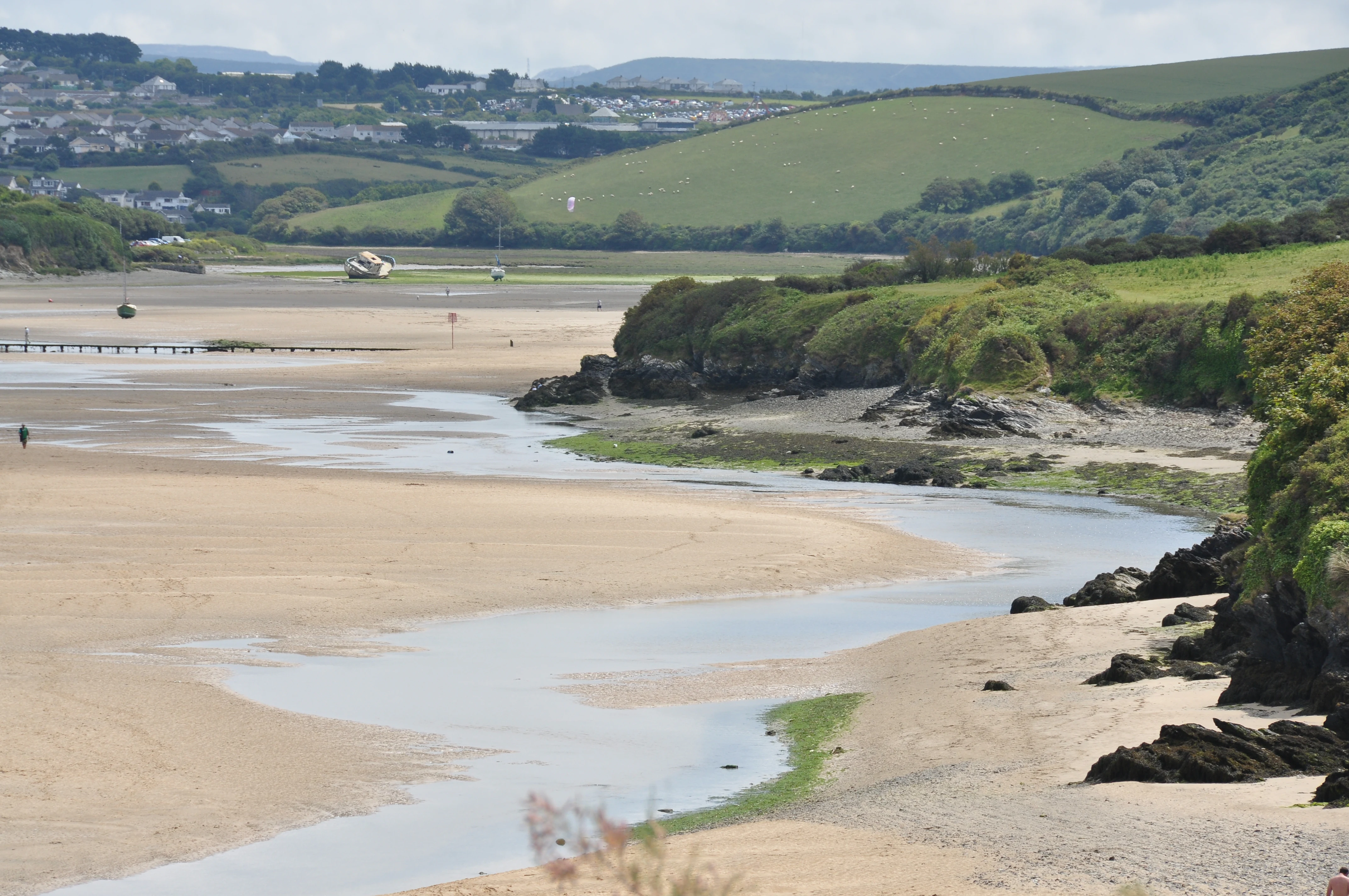
River Gannel above Crantock Beach
The River Gannel estuary flowing above Crantock Beach.

River Gannel history and protected-area timeline

Human activity along the Gannel extends back to the Mesolithic period, with archaeological assessment suggesting the estuary was an important and densely occupied area from the Neolithic onwards, around 4000 BC. Bronze Age roundhouses have been recorded near the river, and in 2007 a 'Wraxall' class neck ring was found at Pentire, indicating late Iron Age habitation in the landscape around the Gannel.

During the medieval period, sandrock was quarried from the beach at Crantock, and later stone from the same deposits may have contributed to the collapse of an earlier tower at St Carantoc's Church in the fourteenth century. Iron ore was mined along Perran Beach, and in the 1860s ore was hauled up the cliff by a 'puffer' engine before being moved from Gravel Hill Mine to a quay on the Gannel. Tin mining at Chiverton Wheal Rose in the eighteenth and nineteenth centuries left further industrial traces, accessed through an adit on the beach.

Shipbuilding also shaped the estuary. Between 1858 and 1881, Thomas and John Clemens constructed ten schooners at Tregunnel on the north shore, while Penpol Creek still preserves a ruined lime kiln that once handled limestone and coal shipments. Until late in the twentieth century the mouth of the Gannel remained in active use for shipping, before silting and the rise of Newquay harbour shifted maritime activity elsewhere. In 2014, storms damaged a wall that altered the river's course, redirecting flow across Crantock beach.

River Gannel landscape and geographic character

The Gannel's setting spans inland agricultural Cornwall and the ruggedly beautiful north Cornish coast. From its modest inland source near Carland Cross, the river descends through rolling country influenced by the Newlyn Downs before reaching the coast. In its lower reaches, it widens into a tidal channel flanked by sandy beaches, dunes, exposed rock platforms, and the steep cleft of Pipers Hole on the west side of the estuary.

The estuary itself is a narrow, dynamic place where sand and water constantly rearrange the shoreline. Crantock beach on one side and the Fern Pit area on the Newquay side give the waterway an enclosed, almost fjord-like feel, while the Pentire headland and surrounding cliffs mark the wider coastal frame. The river's mouth opens directly onto the Celtic Sea, giving the lower Gannel a characteristic mix of dune-backed sand, saltmarsh patches, tidal flats, and exposed rock that shifts with each tide and storm.
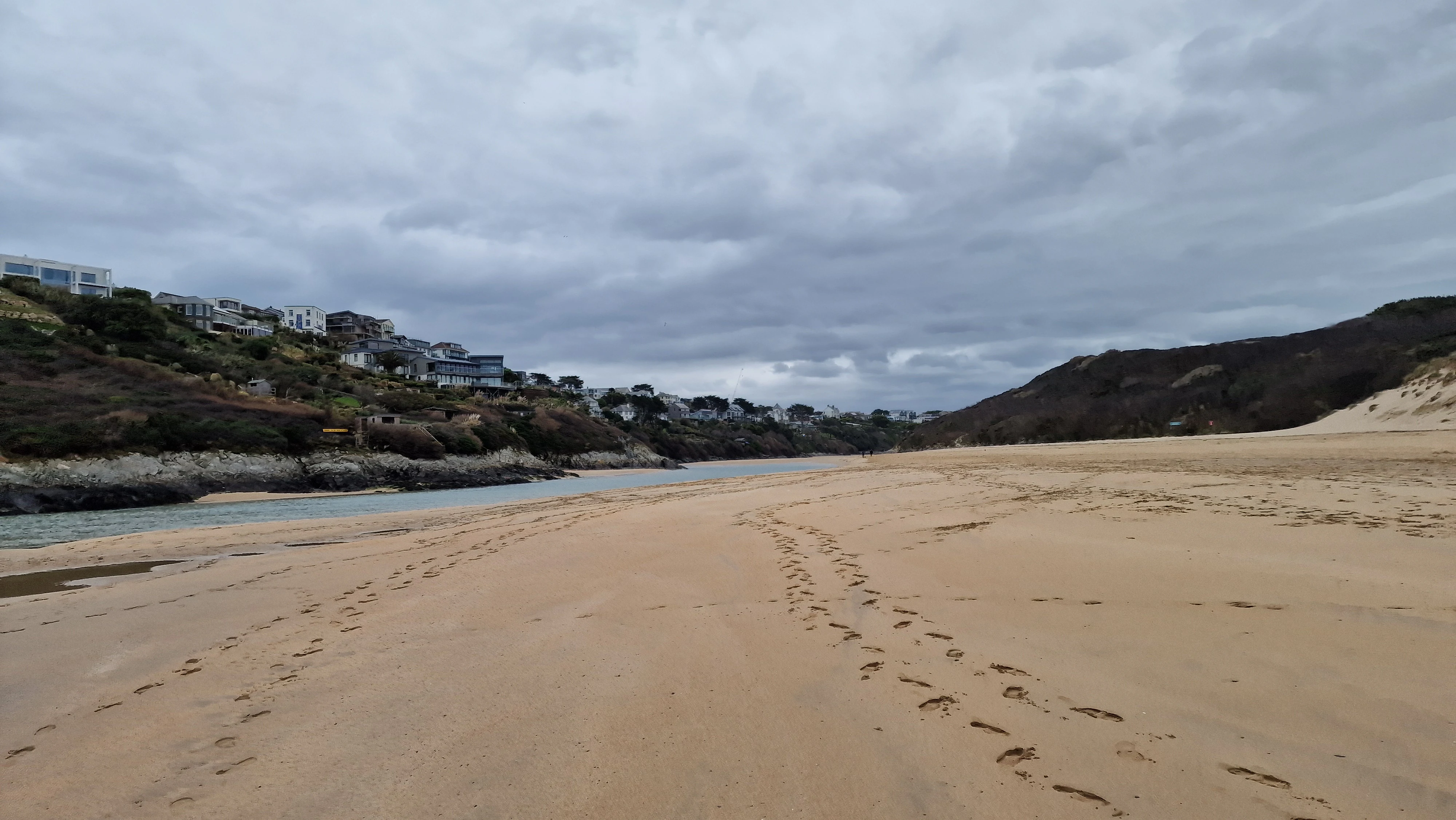
A wide angle view of a sandy tidal river estuary at low tide, with residential buildings on a hillside to the left and a cloudy sky above.
Low tide at the River Gannel estuary near Newquay.

River Gannel ecosystems, habitats, and plant life

Ecologically, the Gannel is a layered system that shifts from freshwater river to brackish channel and finally to a marine-influenced estuary. The Newlyn Downs and surrounding farmland shape much of the freshwater catchment, creating a relatively sheltered inland stretch that supports species such as trout, lamprey, eel, and bullhead.

Downstream, the estuary's mix of sand, mud, rock, and tidal movement creates productive habitat for both resident and visiting wildlife. Below the low water mark, communities of anemones, sponges, sea mats, and sea squirts thrive, while intertidal flats offer feeding grounds for migratory birds and seabirds. Pipers Hole, a deep cleft on the west side of the beach, is an important nesting site for fulmars, jackdaws, and pigeons, weaving seabird cliff habitat directly into the estuarine environment. Weever fish are commonly encountered in the shallows, particularly at low tide, while the protected status of the estuary adds a layer of conservation significance to a naturally varied coastal ecosystem.
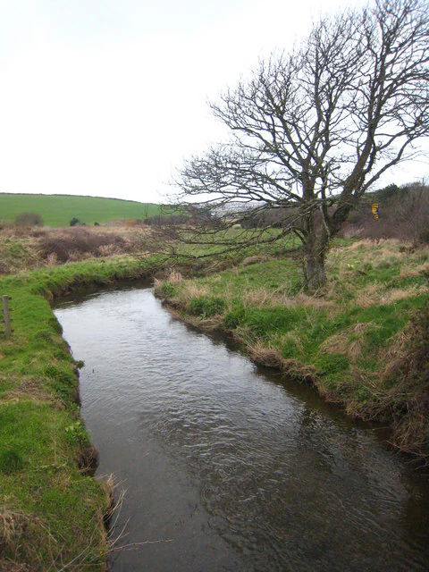
A narrow, meandering river flows through a green landscape with a large bare tree in the foreground and rolling hills in the distance.
The River Gannel flowing through a grassy landscape near Trevemper Bridge.

River Gannel wildlife and species highlights

The Gannel estuary is recognised primarily as a haven for migratory and coastal birds, with Pipers Hole serving as a notable nesting location for fulmars, jackdaws, and pigeons. The mix of dunes, cliff, and tidal flat provides a range of feeding and roosting conditions that make the estuary attractive to species moving along the Cornish coast.

Within the Marine Conservation Zone, the rare giant goby finds refuge among the estuary's varied underwater habitats, illustrating the area's importance for less conspicuous but ecologically valuable species. Lower down the food chain, communities of anemones, sponges, sea mats, and sea squirts create a rich subtidal substrate, while weever fish are common visitors to the shallow waters, especially at low tide. In the freshwater stretches above the tidal limit, trout, lamprey, eel, and bullhead have all been recorded, completing a wildlife profile that ranges from upland river species to coastal marine fauna.

River Gannel conservation status and protection priorities

The single most important conservation designation along the Gannel is the Newquay and the Gannel Marine Conservation Zone, formally designated in January 2016. This designation covers the estuary up to the tidal limit, recognising its role as habitat for migratory birds, rare fish such as the giant goby, and a varied subtidal community of anemones, sponges, sea mats, and sea squirts.

Beyond the formal zone, the Gannel's value also lies in how its varied habitats connect: freshwater river species upstream, estuarine transitions in the middle reaches, and marine species downstream. Together these create a continuum of protected and partially protected environments that help buffer coastal biodiversity against broader pressures on the Cornish coastline. The MCC's designation has reinforced the estuary's profile as one of the more ecologically distinctive river mouths in north Cornwall.

River Gannel cultural meaning and human context

The Gannel sits within a Cornish cultural landscape shaped by long human use of the coast and rivers. Archaeological evidence points to Mesolithic, Neolithic, Bronze Age, and Iron Age occupation around the estuary, with named finds such as the Wraxall neck ring giving tangible expression to that deep history. Medieval stone quarrying, Iron Age and later metalwork, and nineteenth-century shipbuilding at Tregunnel all reflect continuing human engagement with the river and its shores.

The Gannel Crake, a mysterious sound heard over the estuary, has been part of local folklore for centuries, traditionally explained as the cry of a troubled spirit haunting the scene. Nineteenth-century accounts described it as resembling a thousand voices combined in a long, fading wail, and the legend remains embedded in local memory. A traditional seasonal ferry still operates between the Fern Pit and Crantock beach, keeping older patterns of movement across the estuary alive, while artists such as William Prater captured the river in paintings like Crossing the Gannel.

Top sights and standout views in River Gannel

The Gannel combines a compact, distinctive tidal estuary with a long record of human use and a recently strengthened conservation profile. Its defining qualities include the channel between Newquay and Crantock, the Marine Conservation Zone, and the estuary's role as habitat for migratory birds and the rare giant goby.

Equally notable are the layered industrial and prehistoric histories visible along its banks, from Bronze Age roundhouse sites to nineteenth-century lime kilns and shipyards. The seasonal ferry, the legend of the Gannel Crake, and the dramatic dune-and-cliff setting at the river's mouth give the Gannel a character that is at once intimate, historic, and distinctly Cornish.

Best time to visit River Gannel

The character of the Gannel changes meaningfully with the seasons, making different periods appealing for different interests. Summer brings warmer weather, calmer sea conditions, and the operation of the seasonal ferry between the Fern Pit and Crantock beach, offering easier access to both sides of the estuary and good conditions for exploring the dunes and sandy shores.

Spring and autumn are often rewarding for wildlife interest, when migratory birds are more active along the estuary and the surrounding beaches are quieter. Winter can be dramatic, when storms reshape channels and dunes; this is when events such as the 2014 breach occurred, redirecting flow across Crantock beach. Tide times are always important to consider: low water exposes rich intertidal life and bird feeding areas, while higher tides narrow the channel and emphasise the estuary's enclosed, river-like character.
Monthly climate preview

Long-term representative point measurements tracking monthly weather patterns in Cornwall

River Gannel Climate Normals, Annual Temperature and Precipitation Rhythm

Representative coordinate records show measured average temperatures ranging from 7.48 degrees Celsius to 16.68 degrees Celsius alongside recorded monthly precipitation rates. Detailed twelve-month climatology records provide comprehensive weather data for comparative geographical analysis.
Annual mean12 °C
7 °C17 °C
Jan
Feb
Mar
Apr10°
May12°
Jun14°
Jul16°
Aug17°
Sep15°
Oct13°
Nov11°
Dec
Warmest month
August

16.7 °C

Coolest month
February

7.5 °C

Wettest month
November

4.3 mm/day

Driest month
May

2.2 mm/day

Park location guide

Geography guide, regional context, and park location map for River Gannel

River Gannel park geography, regions, and map view in United Kingdom

Understand where River Gannel sits in United Kingdom through a broader geographic reading of the surrounding landscape, nearby location context, and its mapped position within the national park landscape.

How River Gannel fits into United Kingdom

The United Kingdom is a parliamentary constitutional monarchy located in northwestern Europe, consisting of four constituent countries: England, Scotland, Wales, and Northern Ireland. As a major global power with over 69 million residents, it maintains significant international influence in politics, economics, and culture.

Wider geography shaping River Gannel in United Kingdom

The United Kingdom is an island nation located in northwestern Europe, surrounded by the Atlantic Ocean, North Sea, English Channel, Celtic Sea, and Irish Sea. It shares a land border with the Republic of Ireland to the west. The territory includes the island of Great Britain, the northeastern portion of Ireland, and most of the smaller British Isles islands.

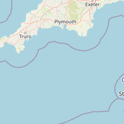
Map view of River Gannel

Use this park location map to pinpoint River Gannel in United Kingdom, understand its exact geographic position, and read its mapped placement within the surrounding landscape more clearly.

Pigeon | © OpenStreetMap contributors

Location context for River Gannel

CornwallEngland

Examine protected area views, tidal channels, and coastal habitats.

River Gannel Photos and Landscape Scenery Visual Exploration

Visual records capture the shifting sand dunes, exposed rock platforms, and marine conservation zones that define the north Cornwall coast. Detailed photography reveals the unique estuarine terrain, intertidal habitats, and coastal geography surrounding the waterway.

River Gannel above Crantock Beach

A small ferry boat docked at a stone landing site on the banks of the River Gannel, with wooded cliffs and a building visible in the background.

A wide angle view of a sandy tidal river estuary at low tide, with residential buildings on a hillside to the left and a cloudy sky above.

A narrow, meandering river flows through a green landscape with a large bare tree in the foreground and rolling hills in the distance.

Park atlas

Compare adjacent marine reserves, tidal estuaries, and regional coastal habitats

Other Parks Near River Gannel and Surrounding Protected Coastal Landscapes

Browsing parks near River Gannel reveals connected coastal ecosystems and protected tidal environments across the north Cornwall region. Expanding the geographic comparison highlights wider regional terrain, shifting dunes, and neighboring conservation landscapes.
Marine protected areaCornwall
About 41 km away#1 closest

South

The Manacles Marine Protected Area: Coastal Geography and Underwater Reef Map

Detailed geographic analysis of the Lizard Peninsula marine environment

The Manacles serves as a critical marine protected area featuring an intricate layout of jagged rock clusters, maerl beds, and historical shipwreck sites. This atlas entry provides a structured look at the reef geography, submerged terrain characteristics, and the environmental significance of this landmark formation within the waters of Falmouth Bay.

Area
3.5 km²
Established
2013
Relief
Lowland
Climate
Temperate
A soft watercolor illustration depicting a coastal landscape with green marshy vegetation, a calm body of water, and rolling hills in the background.
Marine protected areaCornwall
About 45 km away#2 closest

Southwest

Mounts Bay Marine Conservation Zone: Exploring Marine Protected Areas in South Cornwall

Subtidal reefs and coastal seagrass habitats in the English Channel.

This protected marine landscape off the coast of Cornwall covers diverse underwater habitats including the Greeb reef and the waters surrounding St Michael's Mount. The area is characterized by its significant seagrass beds, which act as vital nursery habitat for fish and shellfish species. Explore the structural geography of this marine protected area and its position within the broader coastal environment of South West England.

Area
12 km²
Established
2016
Relief
Lowland
Climate
Temperate
A pale, minimalist watercolor painting showing soft green hills and a gentle shoreline against a white background.
Protected landscapeCornwall
About 57 km away#3 closest

Southwest

Gwennap Head Protected Landscape: Coastal Geography and Granite Cliffs in Cornwall

Mapped Atlantic terrain and regional maritime boundaries

Located at the western edge of the Penwith peninsula, Gwennap Head defines a harsh yet productive coastal environment. This protected landscape features vertical granite cliffs, the treacherous Runnel Stone reef, and open maritime heath. Its geography serves as a vital watchpoint for migratory seabirds and a nexus of historic maritime activity, offering a well defined study of Cornwall's exposed Atlantic coastline.

Relief
Upland
Climate
Temperate
Access
Easy access
Scope
Mixed
Watercolor illustration of Dartmoor moorland landscape with rolling hills, grassy vegetation, a stream, and distant mountains.
National parkDevon
About 70 km away#4 closest

East

Dartmoor National Park: Granite Tors and Prehistoric Landscape in Devon

Mapped protected area with significant Bronze Age remains.

Dartmoor National Park represents a distinctive granite upland in Devon, England, characterized by its dramatic tors and expansive moorland. This protected landscape is globally significant for its dense concentration of prehistoric archaeological sites, including stone circles, standing stones, and ancient settlements. Exploring Dartmoor offers a unique insight into Britain's regional geography, mapped terrain, and enduring connection to ancient human history.

Area
954 km²
Established
1951
IUCN
V
Visitors
11M annual
A soft watercolor illustration featuring rolling hills in the background, a tree line in the midground, and a winding waterway in the foreground.
Biosphere reserveDevon
About 91 km away#5 closest

Northeast

North Devon's Biosphere Reserve: Protected Landscapes and Geographic Map Exploration

Coastal dunes, estuaries, and marine habitats in North Devon

An extensive overview of North Devon's Biosphere Reserve, highlighting its role as a protected landscape in South West England. Analyze the distribution of its diverse terrain, including Britain's largest sand dune system, river catchments, and offshore coral reefs, through detailed geographic and habitat mapping.

Area
5,262 km²
Established
1976
Visitors
4M annual
Relief
Lowland
Watercolor painting depicting a landscape with rolling hills, a winding road, and distant mountains
National parkUnited Kingdom
About 117 km away#6 closest

Northeast

Exmoor National Park: A Premier Protected Landscape in South West England for Atlas Exploration

Mapped terrain, moorland, and dramatic coastal geography.

Discover Exmoor National Park, a vast protected area in South West England celebrated for its sweeping heather moorland, dramatic coastline with the highest sea cliffs on mainland Britain, and deep, ancient wooded valleys. This national park offers a unique landscape for atlas-based exploration, revealing its distinct geography, mapped boundaries, and rich terrain shaped by centuries of natural processes and human activity.

Area
692 km²
Established
1954
IUCN
V
Visitors
1.4M annual
Watercolor painting of a coastline with rolling green cliffs meeting the sea, with small pink flowers in the foreground.
Protected landscapeUnited Kingdom
About 125 km away#7 closest

East

Jurassic Coast Protected Landscape: Geological Mapping and Coastal Atlas

A comprehensive look at sedimentary formations in the United Kingdom

Trace the 96-mile stretch of the Jurassic Coast, a protected landscape revealing Triassic, Jurassic, and Cretaceous rock layers. The terrain serves as a vital record of Earth history, featuring distinctive geomorphological landmarks like Chesil Beach and the towering cliffs of Golden Cap, all defined by the dynamic interaction of land and sea.

Established
2001
Relief
Upland
Climate
Temperate
Access
Easy access
National parkPembrokeshire
About 133 km away#8 closest

North

Pembrokeshire Coast National Park: Mapped Coastal Boundaries and Protected Landscape Atlas

Explore unique seaside terrain and regional geography.

Delve into the Pembrokeshire Coast National Park, a premier protected landscape recognized for its extraordinary coastal formations and diverse natural terrain. This atlas entry details the park's distinct mapped boundaries, from its iconic limestone cliffs and sea stacks to its sheltered estuaries and inland Preseli Hills. Understand how this significant national park contributes to the protected area map of Pembrokeshire and offers unparalleled opportunities for geographic discovery along the Welsh coast.

Area
629 km²
Established
1952
IUCN
V
Relief
Mixed relief

Common questions about visiting, size, designation, and location context for River Gannel

River Gannel FAQs for park facts, access, geography, and protected area context

Find quick answers about River Gannel, including protected-area facts, park geography, trail and visitor context, and how the park fits into its surrounding country and regional landscape.
MoriAtlas Explorer

Continue Your Protected Areas Search Across the Global Atlas

Deepen your exploration by continuing the structured search for national parks and protected areas worldwide. Utilize the comprehensive filtering capabilities to compare different conservation landscapes and refine your understanding of global park geography. Discover more about the distribution and characteristics of protected natural areas.

Global natural geography