
Mori Atlas logo
Nature reserveRoc de Chère

Examine the intersection of limestone cliffs, sandstone ridges, and glacial relicts in this unique Haute-Savoie headland.

Roc de Chère Nature Reserve: A Detailed Geographic Overview of Protected Landscapes in the French Alps

(Réserve naturelle nationale du Roc de Chère)

Roc de Chère is a compact, botanically rich nature reserve situated on the eastern shore of Lake Annecy in France. Spanning a small but geologically diverse promontory, this protected area features a striking convergence of warm sub-Mediterranean flora and cold subalpine species. The landscape contains a complex mosaic of karstic limestone pavements, acidic sandstone formations, and a glacial-relict bog that together support an extraordinary density of plant life within a localized forest ecosystem.

national nature reservelimestone headlandLake AnnecyHaute-SavoieFrench Alpsbotanical reserve
A stylized vector illustration of a mountainous landscape with cliffs, a waterfall flowing into a lake, trees in the foreground, and a sun rising over the peaks.

Roc de Chère

Nature reserve

Park overview

Structured park overview, official facts, and landscape profile for Roc de Chère

Roc de Chère park facts, protected area profile, and essential visitor context

Review the core facts for Roc de Chère, including designation, size, terrain, visitor scale, habitats, and operating context in one park-focused overview.

About Roc de Chère

Roc de Chère is one of the most botanically surprising protected sites in the French Alps. Located on the eastern shore of Lake Annecy, between Talloires and Menthon-Saint-Bernard, the headland was shaped by the Quaternary glacier that once occupied the Annecy basin. That glacial action produced a compact but highly varied topography: limestone cliffs falling into the lake, acidic sandstone ridges, a sandy-calcareous central depression, a small boggy valley, and a cooler, humid central plateau on the shady slope. Each of these micro-landscapes supports its own ecological character.

What makes the site exceptional for its size is the meeting of two very different floras. The cool, humid microclimates, fed by glacial relicts and sandstone acid soils, allow species typical of mountain and subalpine environments to grow here: rusty-leaved rhododendron, fir clubmoss (Huperzia selago), bog sedges, and lichens often found much higher in the Alps. In contrast, the sun-drenched cliffs above the lake create hot, dry conditions that host sub-Mediterranean species such as Montpellier maple, capillary fern, madder, and boxwood. The result is more than 560 recorded plant species in just 69 hectares, a concentration that has made the site a reference case for micro-endemism and ecological mosaics in low- to mid-elevation Alpine terrain.

The headland is also a defining landmark of the Lake Annecy landscape. Standing at 656 m and dropping 200 m to the lake, it marks the boundary between the Grand Lac and the Petit Lac and frames the celebrated bay of Talloires. Forests of sessile oak and hornbeam cover much of the reserve today, while rhododendron heathlands flower on parts of the slope. Beyond its natural significance, Roc de Chère has long human ties: it was historically exploited by the monks of the Abbey of Talloires, and the tombs of philosopher and historian Hippolyte Taine and his family rest on the promontory.

Quick facts and research context for Roc de Chère

Roc de Chère is a wooded limestone headland on the eastern shore of Lake Annecy, in the Haute-Savoie department of the Auvergne-Rhône-Alpes region, France. It falls within the Massif des Bornes of the French Alps and reaches an elevation of 656 m, plunging toward the lake (448 m) in cliffs 50 to 70 m high.

A national nature reserve (RNN 36) covering about 69 hectares was created on 2 November 1977, and roughly 35 percent of that surface is owned by the Conservatoire du littoral. The reserve is managed by ASTERS, the Conservatoire d'espaces naturels de Haute-Savoie, and is classified as IUCN Category IV (habitat/species management area).

Protection and recognition

Documented terrestrial protection history and recognition data

Roc de Chère Protection Status and Designated Area Records

Roc de Chère maintains recorded terrestrial protection status established in 1977 within global conservation inventories. Atlas records compile official designation history and management scope for verified protected areas.

Protection details

Protection scope
Terrestrial
Designated year
1977
Transboundary protection
No
WDPA ID
15157
Park context

Deeper park guide and search-rich context for Roc de Chère

Roc de Chère history, landscape, wildlife, and travel context

Explore Roc de Chère through its history, landscape character, ecosystems, wildlife, conservation priorities, cultural context, and seasonal travel timing in a structured park guide built for atlas discovery and search intent.

Why Roc de Chère stands out

Roc de Chère is best known for being a tiny reserve with an unusually rich flora, where more than 560 plant species grow on a mosaic of limestone and sandstone soils. Its most celebrated botanical feature is the coexistence of two normally separated flora: a cold, subalpine and arctic-alpine flora (rhododendron, Huperzia selago, bog sedges, lichens) and a warm, sub-Mediterranean flora (Montpellier maple, capillary fern, madder, boxwood) thriving on the same site. It is also known for a small Sphagnum bog, a relict of the Quaternary glacier that once filled the Annecy basin, and for the rare Northern Emerald dragonfly (Somatochlora arctica) that breeds there. Lacustrine cliffs provide nesting habitat for rock swallows and peregrine falcons, while humid hollows shelter amphibians such as the yellow-bellied toad.
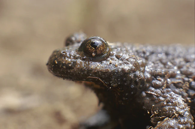
A close-up, side-profile view of a yellow-bellied toad showing its bumpy, textured, grey-brown skin and a dark, prominent eye.
A close-up view of a yellow-bellied toad, a protected amphibian species found within the Roc de Chère nature reserve.

Roc de Chère history and protected-area timeline

Roc de Chère was already part of the cultural landscape of the medieval Alps long before it became a nature reserve. The place is first mentioned around 1031 to 1032, when Queen Ermengarde of Burgundy made a donation to the Abbey of Saint-Martin de Savigny that included the forest of "Cheria," the early form of the name. Through the Middle Ages the woodlands of the headland were used by the monks of the Abbey of Talloires, whose exploitation shaped parts of the forest cover seen today.

The modern conservation history of the site began in the late 1970s. A national nature reserve was created by decree on 2 November 1977 to protect the site from increasing pressure around one of France's most visited lakes. At the time, it was only the second nature reserve created in Haute-Savoie, after the nearby Aiguilles Rouges reserve. Roughly 35 percent of the protected area is today owned and managed by the Conservatoire du littoral et des rivages lacustres, while ASTERS, the Conservatoire d'espaces naturels de Haute-Savoie, manages the reserve under successive management plans.

A local legend ties the promontory to Bernoline d'Angon, a young noblewoman said to have thrown herself into the lake from Roc de Chère after her husband was carried off by the devil; her spirit is fabled to drag swimmers down while searching for him. More tangibly, the site also carries the tombs of the historian and philosopher Hippolyte Taine, his wife Thérèse Denuelle, and her father Alexandre Denuelle.

Roc de Chère landscape and geographic character

Roc de Chère is a compact geological showcase in the Massif des Bornes, where two very different rock types produce dramatically different landscapes within a few hundred meters. The foundation is calcareous, with limestone cliffs plunging 50 to 70 m from the summit down to the lake at 448 m; these warm, sunny, south- and west-facing slopes are shaped by erosion into karstic features, including the lapiaz (limestone pavements) typical of Savoie.

On the opposite side of the ridge, the local geology shifts to sandstone, producing acidic, often cooler soils. The result is a strikingly varied topography that can be divided into five natural units: lake-facing limestone cliffs, acidic sandstone ridges, a sandy and calcareous central depression, a small boggy valley, and a fresh, humid central plateau on the shady (ubac) side. The boggy hollow is itself a relict of the Quaternary glacier that once filled the Annecy basin, and karstic caves, including the well-known Grand Pertuis opening onto the Bay of Talloires, lie hidden beneath the forests at the base of the headland.
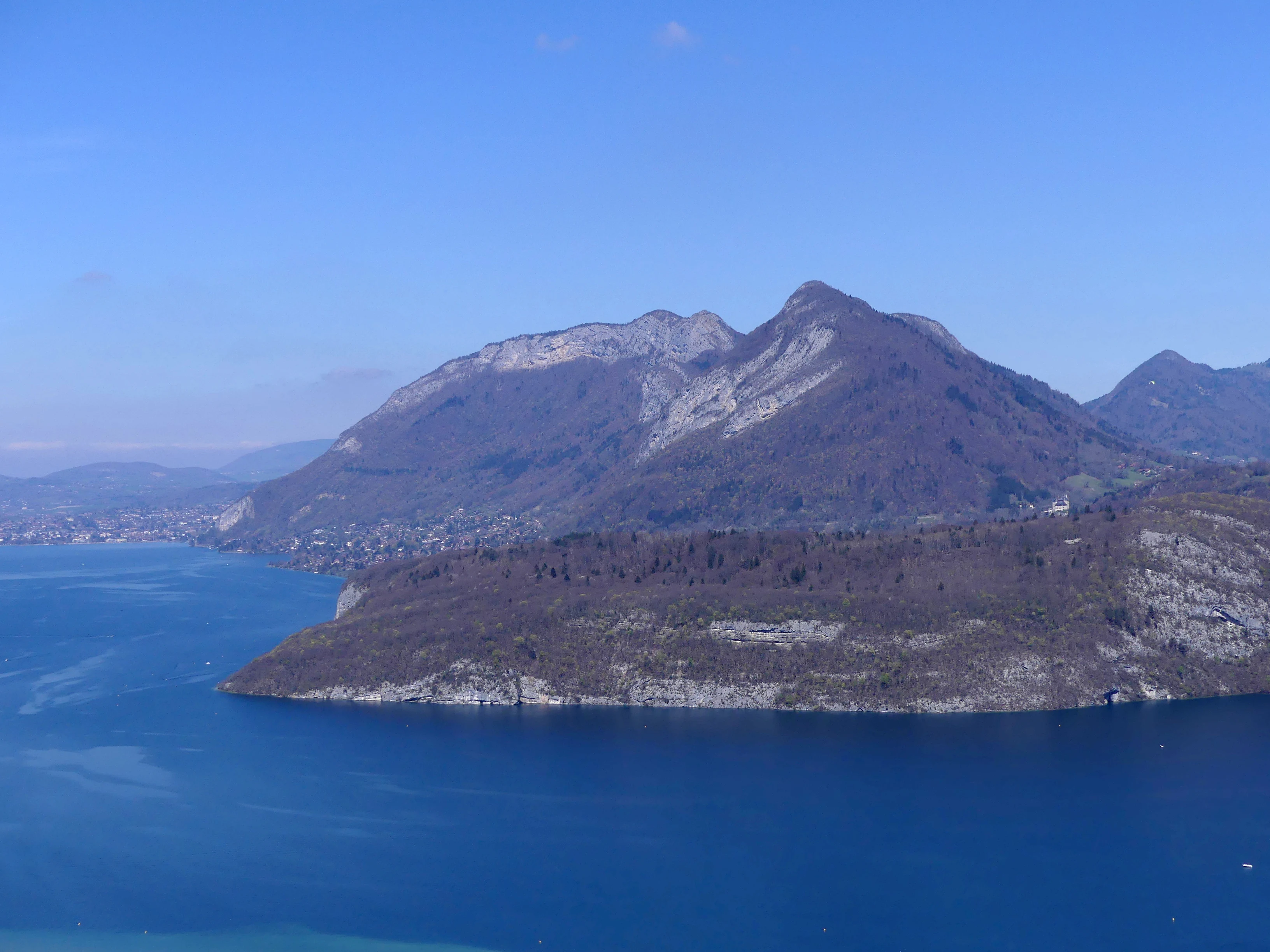
A high angle panoramic view showing a rocky, forested headland jutting into a large blue lake, with mountains rising in the background under a clear sky.
A scenic view of the Roc de Chère headland extending into the blue waters of Lake Annecy.

Roc de Chère ecosystems, habitats, and plant life

Despite its tiny footprint, Roc de Chère ranks among the most botanically rich protected sites in the French Alps. The combination of alternating calcareous and siliceous soils, varied topography, and contrasting exposures creates a mosaic of microclimates that host more than 560 species of flowering plants and ferns, along with notable cryptogams.

Two opposing floras coexist here. The first is a glacial or arctic-alpine assemblage of mountain and subalpine species, including rusty-leaved rhododendron, fir clubmoss (Huperzia selago), the bog sedge Carex limosa, and various lichens. Many of these species usually grow only at much higher elevations; their survival here is linked to cool, humid, sandstone-driven microclimates and to a small Sphagnum bog left behind by the retreating Quaternary glacier. The second flora is markedly thermophilic, with southern and sub-Mediterranean elements such as Montpellier maple, capillary fern, wild madder, and boxwood flourishing on the hot, dry cliffs that face the lake.

Between these extremes lies a varied woodland of sessile oak and hornbeam, occasional heathlands of rhododendron (rhodoraies), and a mosaic of wet hollows that support specialized bog plants such as sundews (Drosera) and bog sedges. This compression of ecological zones into such a small area is what gives Roc de Chère its scientific importance.
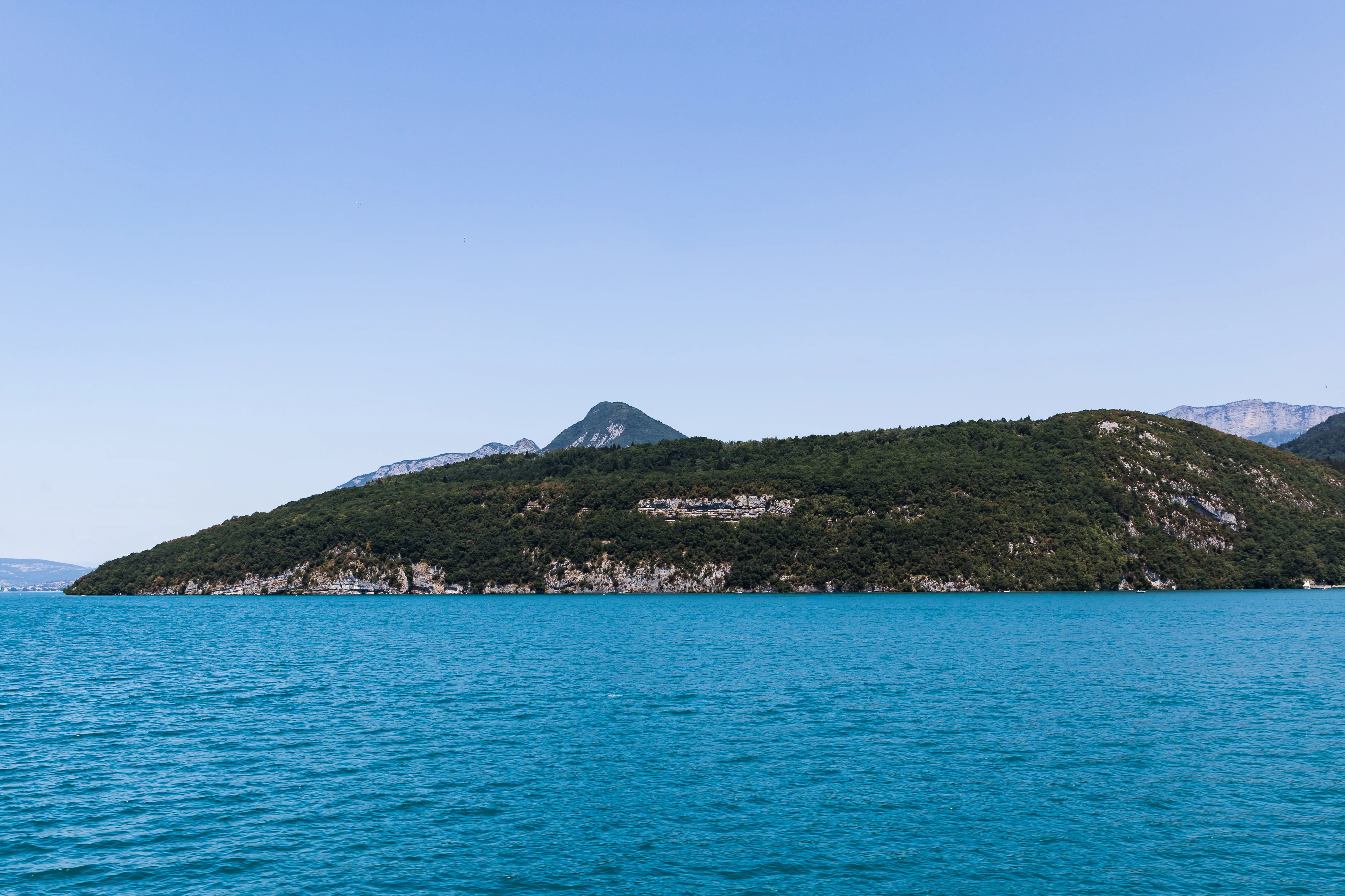
A wide scenic view across the bright blue water of Lake Annecy toward the forested, rocky southern slopes of the Roc de Chère headland, with a taller peak in the background under a clear sky.
The southern slope of Roc de Chère as seen from the waters of Lake Annecy.

Roc de Chère wildlife and species highlights

Roc de Chère's wildlife profile reflects the same compressed mosaic that shapes its flora. The lake-facing cliffs provide important nesting habitat for birds that need bare rock and open airspace above water, including rock swallows and peregrine falcons, while the airspace above the reserve is regularly used by black kites, and the lake itself by Yellow-legged Gulls.

The wetland microhabitats, especially the Sphagnum bog and damp hollows, are home to characteristic amphibians and invertebrates: the common frog and fire salamander breed in the moist zones, while the rare yellow-bellied toad (Bombina variegata) finds refuge in the sunnier puddles and seepages. The bog also hosts the Northern Emerald dragonfly (Somatochlora arctica), a species of strong conservation interest in the Alps.

The varied woodland of oaks and hornbeam, combined with cliff, bog, and lake-edge habitats in immediate proximity, makes the reserve a remarkably dense refuge for invertebrates, amphibians, and cliff-nesting birds in an otherwise heavily developed lakeside landscape.
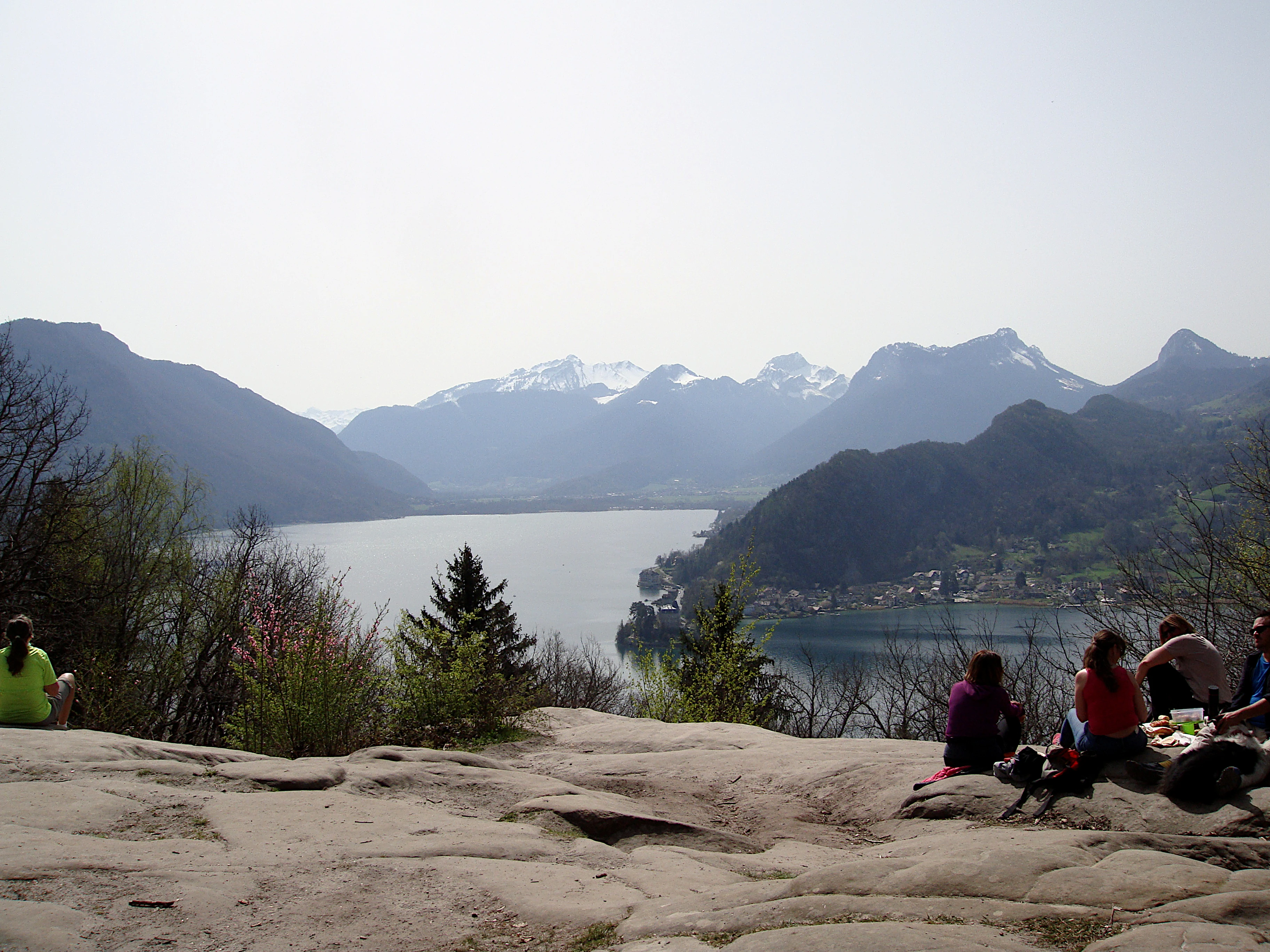
A wide angle view from a rocky hilltop overlooking a large lake surrounded by mountains, with several hikers resting on the foreground rocks.
Panoramic view of Lake Annecy seen from the Roc de Chère summit, a popular hiking destination.

Roc de Chère conservation status and protection priorities

The conservation significance of Roc de Chère lies in the fact that a very small, low- to mid-elevation site can shelter an exceptionally high density of plant species, including several that are normally restricted to much higher altitudes or much warmer Mediterranean climates. Protecting these microhabitats in situ is essential because the species involved are tightly tied to very specific soil and microclimate conditions.

The reserve was created by decree on 2 November 1977 as the second national nature reserve in Haute-Savoie, after the Aiguilles Rouges reserve, and was elevated further when a substantial portion of its surface was acquired by the Conservatoire du littoral et des rivages lacustres, securing the site against lakeside development pressure. Daily management is handled by ASTERS, the Conservatoire d'espaces naturels de Haute-Savoie, under successive management plans.

The reserve's regulations reflect a strong conservation focus: collection of plants, fossil collecting, bivouacking, dogs (even on a leash), and overflights below 300 m are prohibited, while traditional activities such as alpine pasture management, forestry, regulated hunting, and fishing within defined limits are tolerated. This combination of strict protection of fragile biological assets and a controlled framework for traditional land use is central to the site's conservation strategy.

Roc de Chère cultural meaning and human context

Roc de Chère sits within the historical and cultural landscape of Lake Annecy, one of the most iconic lake basins of the French Alps. The first documentary mention of the site appears in a donation between August 1031 and September 1032, when Queen Ermengarde of Burgundy ceded the "forest of Cheria" to the Abbey of Saint-Martin de Savigny, anchoring the promontory in the medieval monastic network of Savoie. Through subsequent centuries the woodlands were managed by the monks of the Abbey of Talloires, whose imprint is still visible in parts of the current forest cover.

The site also carries a strong literary and memorial dimension. The tombs of the nineteenth-century philosopher and historian Hippolyte Taine, his wife Thérèse Denuelle, and her father Alexandre Denuelle are located on the headland, linking the natural site to French intellectual history. Local folklore, including the legend of Bernoline d'Angon, weaves the promontory into the identity of the lake, while the caves at its foot, including the Grand Pertuis at Talloires, attracted the attention of artists such as Albert Besnard, who etched and painted their interiors in the early twentieth century.

Top sights and standout views in Roc de Chère

Roc de Chère stands out for packing more than 560 plant species into just 69 hectares, a botanical density that reflects an extraordinary convergence of limestone and sandstone geology, glacial relicts, and sharply contrasting microclimates on the edge of Lake Annecy. Its cliff-nesting raptors and swallows, its Sphagnum bog with rare dragonflies and amphibians, and its sub-Mediterranean flowers on hot lake-facing rocks together form one of the most compact ecological mosaics in the French Alps.

The reserve's status since 1977, partial ownership by the Conservatoire du littoral, and ongoing management by ASTERS give it a particularly robust conservation framework. Combined with its defining role in the Lake Annecy landscape and its historical depth, this makes Roc de Chère a high-value site both ecologically and culturally.

Best time to visit Roc de Chère

Roc de Chère can be visited year-round, but its character shifts strongly with the seasons along Lake Annecy. Spring brings the rhododendron and the resurgence of the rich understory in the oak-hornbeam forests, with mild temperatures ideal for walking the cliff-side paths. Summer is the busiest period around the lake, with warm, dry conditions on the cliff faces that also coincide with the flowering of the more thermophilic plants such as Montpellier maple and various orchids in open rocky spots.

Autumn offers a quieter setting, with cooler, damper air that highlights the bog vegetation and the humid microclimates of the central plateau, when mosquitoes and dragonflies are less intense. In winter, the prominence can be cold and occasionally snowy, with shorter days, but the bare deciduous canopy and clear views across the lake can be especially atmospheric. Because the reserve is small and much of its interest is botanical, the period from late spring to early autumn generally provides the most rewarding visit.

Monthly climate preview

Measured temperature and precipitation records across representative coordinate elevations

Roc de Chère Climate Normals and Long-Term Weather by Month

Long-term NASA Power measurements for Roc de Chère record mean monthly temperatures spanning sub-freezing winter minimums to warm summer maximums alongside steady daily precipitation averages. Examining the complete twelve-month climate profile reveals the full range of historical temperature fluctuations and precipitation totals across the protected landscape.
Annual mean9 °C
-1 °C19 °C
Jan-1°
Feb
Mar
Apr
May12°
Jun16°
Jul19°
Aug19°
Sep14°
Oct10°
Nov
Dec
Warmest month
July

18.5 °C

Coolest month
January

-0.8 °C

Wettest month
December

3.5 mm/day

Driest month
March

2.6 mm/day

Park location guide

Geography guide, regional context, and park location map for Roc de Chère

Roc de Chère park geography, regions, and map view in France

Understand where Roc de Chère sits in France through a broader geographic reading of the surrounding landscape, nearby location context, and its mapped position within the national park landscape.

How Roc de Chère fits into France

France is a unitary semi-presidential republic and one of the world's largest economies. It borders Belgium, Luxembourg, Germany, Switzerland, Italy, Monaco, Andorra, and Spain, with a maritime border to the United Kingdom. The country is known for its cultural influence, art, cuisine, and political history spanning centuries.

Wider geography shaping Roc de Chère in France

France is located in Western Europe. Metropolitan France extends from the Rhine to the Atlantic Ocean and from the Mediterranean Sea to the English Channel and North Sea. The country borders Belgium, Luxembourg, Germany, Switzerland, Italy, Monaco, Andorra, Spain, and has a maritime border with the United Kingdom.

Map view of Roc de Chère

Use this park location map to pinpoint Roc de Chère in France, understand its exact geographic position, and read its mapped placement within the surrounding landscape more clearly.

Pigeon | © OpenStreetMap contributors

Explore visual evidence of limestone cliffs, forested ridges, and varied habitats across the reserve.

Roc de Chere Photos and Landscape Scenery: Visualizing the Protected Area

Visual documentation captures the dramatic topography of limestone cliffs plunging toward Lake Annecy alongside shaded sandstone ridges and boggy hollows. Examining these protected habitats clarifies the complex geological and botanical diversity defining the natural reserve.

A close-up, side-profile view of a yellow-bellied toad showing its bumpy, textured, grey-brown skin and a dark, prominent eye.

A wide, eye-level view of a forested, rocky headland known as Roc de Chère meeting the turquoise waters of Lake Annecy under a clear sky.

A high angle panoramic view showing a rocky, forested headland jutting into a large blue lake, with mountains rising in the background under a clear sky.

A wide scenic view across the bright blue water of Lake Annecy toward the forested, rocky southern slopes of the Roc de Chère headland, with a taller peak in the background under a clear sky.

A wide angle view from a rocky hilltop overlooking a large lake surrounded by mountains, with several hikers resting on the foreground rocks.

Park atlas

Compare surrounding protected areas and connected natural reserves across Haute-Savoie

Parks Near Roc de Chère: Explore Related Protected Landscapes and Regional Geography

Continue exploring regional park geography by comparing protected areas adjacent to Roc de Chère and Lake Annecy. Examining these neighboring natural reserves reveals broader ecological patterns across the French Alps.
Watercolor painting of a soft green alpine landscape with rolling hills, a central body of water, and evergreen trees against a light mountain background.
Nature reserveSavoie
About 27 km away#1 closest

East

Réserve naturelle régionale de la tourbière des Saisies - Beaufortain - Val d'Arly Protected Area Map

High-altitude peatland geography in the Savoie department.

Investigate the complex topography and conservation significance of the Réserve naturelle régionale de la tourbière des Saisies - Beaufortain - Val d'Arly. This protected area stands as a unique alpine landmark, recognized for its subalpine boreal vegetation, rich bird populations, and critical role as a regional peatland sanctuary within the Savoie mountain range.

Area
2.93 km²
Established
2013
IUCN
IV
A watercolor landscape painting showing green hills, trees, and marshy river banks.
Nature reserveGeneva
About 40 km away#2 closest

North

Naturschutzgebiet Moulin de Vert: Protected Wetland and Forest Geography in Geneva

Detailed nature reserve map and regional landscape context

The Naturschutzgebiet Moulin de Vert nature reserve protects a mosaic of riverside woodland, meadows, and managed pond systems along the Rhône in the Canton of Geneva. Spanning approximately 132 hectares, this conservation area is recognized for supporting extensive biodiversity, from nesting peregrine falcons to diverse amphibian populations. Access this detailed geographic perspective to visualize the park boundaries, internal terrain features, and its ecological connection to the broader Swiss river landscape.

Area
1.32 km²
Established
2001
IUCN
IV
A watercolor illustration showing a soft, panoramic view of a calm lake surrounded by gentle, rolling green mountains.
Nature reserveAuvergne-Rhône-Alpes
About 41 km away#3 closest

Southwest

Réserve naturelle régionale du lac d'Aiguebelette: Protected Lake and Forest Geography

Regional nature reserve landscape in the Savoie Prealps

This protected area encompasses the glacial basin of Lake Aiguebelette and the forested slopes of the Montagne de l'Épine. Discover a terrain defined by the contrast between deep mountain water and upland ridgelines, representing a critical habitat and species management zone within the Auvergne-Rhône-Alpes region.

Area
8.442 km²
Established
2015
IUCN
IV
Relief
Mountain
A soft, light watercolor painting of a winding river flowing through a gentle, rolling landscape with trees and distant hills against a pale, warm sky.
Nature reserveAuvergne-Rhône-Alpes
About 46 km away#4 closest

Northwest

Réserve naturelle régionale de la galerie du Pont-des-Pierres Regional Nature Reserve

Protected gorge landscapes and underground habitats in France

An essential record of the Réserve naturelle régionale de la galerie du Pont-des-Pierres, detailing its critical role in safeguarding cliff and underground habitats within the Valserine gorges. This protected land in the Ain department represents a vital ecological intersection of geological features and specialized faunal refuges.

Area
0.093 km²
Established
2009
IUCN
IV
Relief
Mountain
A soft watercolor painting depicting a wide river flowing through a lush green landscape with distant rolling purple hills in the background.
Nature reserveAuvergne-Rhône-Alpes
About 52 km away#5 closest

Southwest

Rhône du Pont de Groslée à Murs-et-Gélignieux: Alluvial Nature Reserve & River Geography

Protected riparian habitat in Auvergne-Rhône-Alpes, France.

Analyze the complex fluvial dynamics of the Rhône du Pont de Groslée à Murs-et-Gélignieux nature reserve. This site features a well-preserved landscape of alder and ash floodplain forests, isolated side channels, and marshy meadows that provide an essential ecological corridor through the Rhône river valley.

Area
21.05 km²
Relief
Lowland
Scope
Terrestrial
Water
Water-dominated
Watercolor painting of green hills and distant pale mountain peaks against a soft pinkish sky.
Nature reserveHaute-Savoie
About 54 km away#6 closest

East

Réserve naturelle nationale du Vallon de Bérard: Geography and Protected Alpine Terrain

High-altitude glacial valleys and crystalline peaks of Haute-Savoie

Situated in the heart of the Aiguilles Rouges massif, Réserve naturelle nationale du Vallon de Bérard preserves a compact mosaic of high-mountain ecosystems. From the Eau de Bérard torrent to the crystalline needles of Aiguille du Belvédère, the reserve provides a protected refuge for alpine species and a rare look at relict glacial landscapes within the French Alps.

Area
5.397 km²
Established
1992
IUCN
IV
Relief
Mountain
Watercolor painting depicting mountains, a river, and trees under a light sky
National parkSavoie
About 60 km away#7 closest

Southeast

Vanoise National Park: Explore France's Original National Park in the Savoie Alps

Mapped Alpine geography, glacial terrain, and protected landscape.

Vanoise National Park is France's pioneering national park, a protected landscape of immense alpine beauty situated in the Savoie department. Renowned for its dramatic glacial terrain, over 100 peaks above 3,000 meters, and the iconic Alpine ibex, this park offers a profound geographic context. Explore its mapped boundaries and discover the unique atlas-level insights into France's mountainous protected areas and their ecological significance.

Area
534 km²
Established
1963
IUCN
II
Relief
Mountain
Nature reserveAuvergne-Rhône-Alpes
About 60 km away#8 closest

West

Réserve naturelle régionale des étangs de Mépieu: Atlas and Geographic Protected Area Overview

Wetlands, peatlands, and dry grasslands in northern Isère

The Réserve naturelle régionale des étangs de Mépieu offers a striking study in ecological contrast. This protected landscape contains a dense mosaic of five ponds and marshy terrain set directly against sun-exposed dry grasslands and heathland slopes. The site serves as a vital corridor for migratory birds and rare flora within the rolling countryside of the Auvergne-Rhône-Alpes region.

Area
1.618 km²
Established
2008
IUCN
IV
Relief
Lowland

Common questions about visiting, size, designation, and location context for Roc de Chère

Roc de Chère FAQs for park facts, access, geography, and protected area context

Find quick answers about Roc de Chère, including protected-area facts, park geography, trail and visitor context, and how the park fits into its surrounding country and regional landscape.
MoriAtlas Explorer

Continue Your Protected Areas Search Across the Global Atlas

Deepen your exploration by continuing the structured search for national parks and protected areas worldwide. Utilize the comprehensive filtering capabilities to compare different conservation landscapes and refine your understanding of global park geography. Discover more about the distribution and characteristics of protected natural areas.

Global natural geography