
Mori Atlas logo
Protected landscapeRogue River–Siskiyou National Forest

Mapping the convergence of the Cascade, Klamath, and Oregon Coast ranges

Rogue River–Siskiyou National Forest: Geography and Protected Landscapes in Oregon

Rogue River–Siskiyou National Forest represents a significant protected landscape spanning southwestern Oregon and northwestern California. This vast area encompasses diverse terrain, including high-elevation volcanic peaks, steep interior canyons, and dense old-growth forests. By bridging three major mountain systems, the forest creates a complex mosaic of ecosystems shaped by powerful river networks like the Rogue, Illinois, and Chetco.

national forestCascade RangeSiskiyou MountainsKlamath MountainsOregon Coast Rangeold-growth forest
A flat, stylized digital illustration of a dense evergreen forest with jagged rocky peaks in the background under a pale sun and light blue sky.

Rogue River–Siskiyou National Forest

Protected landscape

Park overview

Structured park overview, official facts, and landscape profile for Rogue River, Siskiyou National Forest

Rogue River, Siskiyou National Forest park facts, protected area profile, and essential visitor context

Review the core facts for Rogue River, Siskiyou National Forest, including designation, size, terrain, visitor scale, habitats, and operating context in one park-focused overview.

About Rogue River, Siskiyou National Forest

Rogue River–Siskiyou National Forest is one of the most geographically diverse national forests in the Pacific Northwest, encompassing a vast, mountainous landscape between the volcanic Cascade Range, the ancient Siskiyou Mountains, and the forested ridges of the Southern Oregon Coast Range. Its nearly 7,300 square kilometers of terrain straddle the California-Oregon border, making it a shared natural resource between the two states and a defining feature of the southwestern Oregon landscape.

At the core of the forest's identity is the Rogue River, which begins in the Cascades and flows westward through the Klamath and Coast Ranges, joined by major tributaries such as the Illinois River. Shorter coastal rivers, including the Sixes, Elk, Pistol, Chetco, and Winchuck, drain the western slope of the Coast Range directly into the Pacific Ocean, giving the forest an unusually broad and varied hydrology. In addition to its rivers, the forest includes high ridges, deep canyons, and isolated peaks, including Mount Emily, a site of historical interest due to a wartime event described in more detail below.

Ecologically, the forest is a meeting point for multiple forest biomes. Old-growth stands of Port Orford cedar and Douglas fir remain in areas such as the Copper Salmon Wilderness, and a 1993 Forest Service study estimated that roughly 1,397 square kilometers of old growth existed across the forest, with some concentrated in the Red Buttes Wilderness. Botanically significant species include blue oak and canyon live oak, both of which reach the northern or near-northern limits of their range within the forest. The forest's claim to fame within the world of trees is the presence of the tallest known pine: a ponderosa measuring more than 268 feet.

Eight separate wilderness areas lie wholly or partially within the Rogue River–Siskiyou National Forest, protecting roughly 565,900 acres of backcountry. The largest of these, the Kalmiopsis and Siskiyou Wilderness areas, anchor the network and provide crucial habitat connectivity across the region. Combined with the Crater-area geology of the eastern Cascades and the lush river valleys of the coast, the forest supports an exceptional range of outdoor recreation opportunities, including hiking, backpacking, rafting, and wildlife observation.

The forest is administered out of Medford, Oregon, and is structured around local ranger districts in Ashland, Butte Falls, Grants Pass, Jacksonville, Prospect, Cave Junction, Gold Beach, and Powers, each overseeing a portion of this expansive landscape.

Quick facts and research context for Rogue River, Siskiyou National Forest

Rogue River–Siskiyou National Forest is located in southwestern Oregon and the very northwestern corner of California, spanning parts of seven counties across the two states. The forest is administered by the U.S. Forest Service with its headquarters in Medford, Oregon, and is reached through ranger district offices in towns such as Ashland, Butte Falls, Grants Pass, Jacksonville, Prospect, Cave Junction, Gold Beach, and Powers.

Nearly all of the forest is mountainous, intersecting three distinct physiographic regions: the Cascade Range, the Klamath Mountains (including the Siskiyou Mountains), and the Southern Oregon Coast Range. The Rogue River, originating in the Cascades, is the largest river in the forest and is joined by the Illinois River before the system reaches the Pacific. Several shorter rivers, including the Sixes, Elk, Pistol, Chetco, and Winchuck, drain the Coast Range directly to the ocean. The forest is also the home of the world's tallest known pine tree, a ponderosa exceeding 268 feet in height.

Protection and recognition

Documented terrestrial protection scope and international recognition records

Rogue River–Siskiyou National Forest Protection Status and Designation History

Rogue River–Siskiyou National Forest maintains a documented terrestrial protection status established in 2004 across its regional landscape. Structured records outline the official designation history and management scope without external conservation claims.

Protection details

Protection scope
Terrestrial
Designated year
2004
Transboundary protection
No
Park context

Deeper park guide and search-rich context for Rogue River, Siskiyou National Forest

Rogue River, Siskiyou National Forest history, landscape, wildlife, and travel context

Explore Rogue River, Siskiyou National Forest through its history, landscape character, ecosystems, wildlife, conservation priorities, cultural context, and seasonal travel timing in a structured park guide built for atlas discovery and search intent.

Why Rogue River, Siskiyou National Forest stands out

Rogue River, Siskiyou National Forest is especially known for the way it stitches together three major Pacific Northwest mountain systems: the Cascades, the Klamath-Siskiyou ranges, and the southern Oregon Coast Range. This geographic overlap creates a rich mosaic of vegetation types, from high-elevation conifer forests and alpine terrain to the rare Port Orford cedar and Douglas fir old-growth stands of the coastal Siskiyou country. The forest is also recognized for its eight designated wilderness areas, including the large Kalmiopsis Wilderness and Siskiyou Wilderness, which together preserve hundreds of thousands of acres of relatively unroaded backcountry. The Rogue River, one of the most celebrated wild and scenic rivers in the western United States, runs through the forest's heart, and the area's botanical richness, including disjunct populations of California oaks near the northern edge of their range, gives the forest strong ecological and scientific significance.
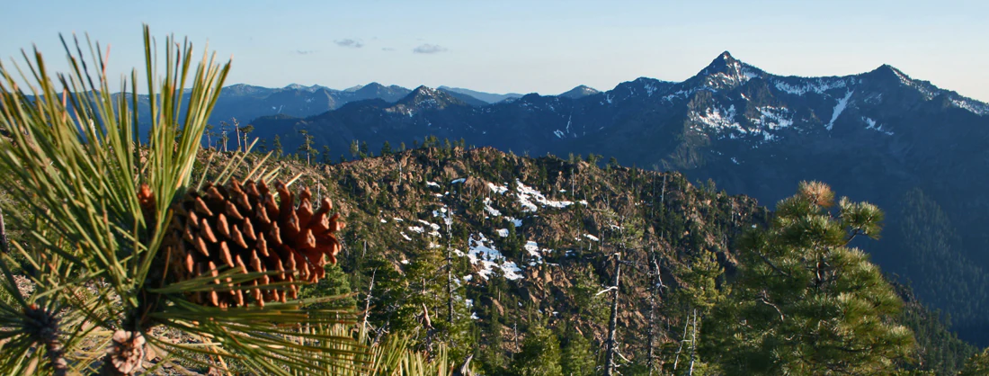
Close-up of a pine cone on a branch in the foreground, with an expansive mountain range featuring rocky slopes and patches of snow visible in the distance under a clear sky.
A Jeffrey pine cone in the foreground with the rugged peaks of the Siskiyou Wilderness in the background.

Rogue River, Siskiyou National Forest history and protected-area timeline

The contemporary Rogue River–Siskiyou National Forest is the product of more than a century of administrative consolidation, beginning with two separate late-nineteenth- and early-twentieth-century forest reserves that evolved over decades into today's combined national forest.

The Siskiyou National Forest was officially established on October 5, 1906. On July 1, 1908, it absorbed the Coquille National Forest along with other lands, helping to shape the early footprint of what would become part of the modern forest. Meanwhile, the lineage of the Rogue River National Forest reaches back further, to the creation of the Ashland Forest Reserve on September 28, 1893, by the United States General Land Office. Those lands were transferred to the Forest Service in 1906, became a National Forest on March 4, 1907, and were then combined with portions of the Cascade, Klamath, and Siskiyou National Forests on July 1, 1908, to establish the Crater National Forest. Further additions followed, including part of the Paulina National Forest in 1915, and on July 9, 1932, the name was changed to Rogue River National Forest.

The two forests remained administratively separate for much of the twentieth century, but in 2004 they were combined into a single unit under the current name, Rogue River–Siskiyou National Forest. This merger brought southern Oregon's iconic river country together with the rugged Klamath-Siskiyou Mountains under one management framework overseen by the U.S. Forest Service from Medford, Oregon.

One of the more unusual historical episodes associated with the forest took place during World War II. On September 9, 1942, an aircraft dropped bombs on Mount Emily in the former Siskiyou National Forest before turning back toward the Pacific Ocean. The bombs detonated and ignited a forest fire that was extinguished by U.S. Forest Service personnel. Bomb fragments bore Japanese markings, and the event was later confirmed to be part of the Lookout Air Raids. Writer Stewart Holbrook described the episode vividly in his essay "First Bomb." The Mount Emily incident became known as the second aerial bombing of the continental United States by a foreign power during the war, taking place roughly three months after the Japanese attack on Dutch Harbor.

Rogue River, Siskiyou National Forest landscape and geographic character

Rogue River–Siskiyou National Forest is defined by its mountainous terrain. Nearly all of the forest lies within rugged uplands, with elevations and exposures shifting quickly from deep river valleys to high ridgelines. The forest spans three physiographic regions: the Cascade Range in the east, the Klamath Mountains and Siskiyou Mountains in the interior, and the Southern Oregon Coast Range in the west, producing a layered landscape that combines volcanic alpine zones, deeply dissected mid-elevation mountains, and forested coastal slopes.

On the eastern side, the Cascade Range portion features the kind of volcanic and glacially influenced topography seen across southern Oregon, while the central Klamath-Siskiyou country is characterized by sharp ridges, isolated peaks, and steep canyons carved by rivers. Notable landmarks such as the Rabbit Ears, a distinctive rock formation in the forest, illustrate the visually memorable character of this terrain. Toward the west, the Southern Oregon Coast Range adds a softer but still heavily forested ridge-and-valley landscape that descends toward the Pacific.

The forest's hydrology shapes its landforms as much as its tectonic and volcanic history. The Rogue River, the largest river in the forest, originates in the Cascades and flows west through the Klamath Mountains and then the Coast Range before exiting the forest. The Illinois River joins the Rogue within the Klamath Mountains, while the Sixes, Elk, Pistol, Chetco, and Winchuck rivers all rise and flow entirely on the western, coastal side of the forest, draining directly into the Pacific Ocean.
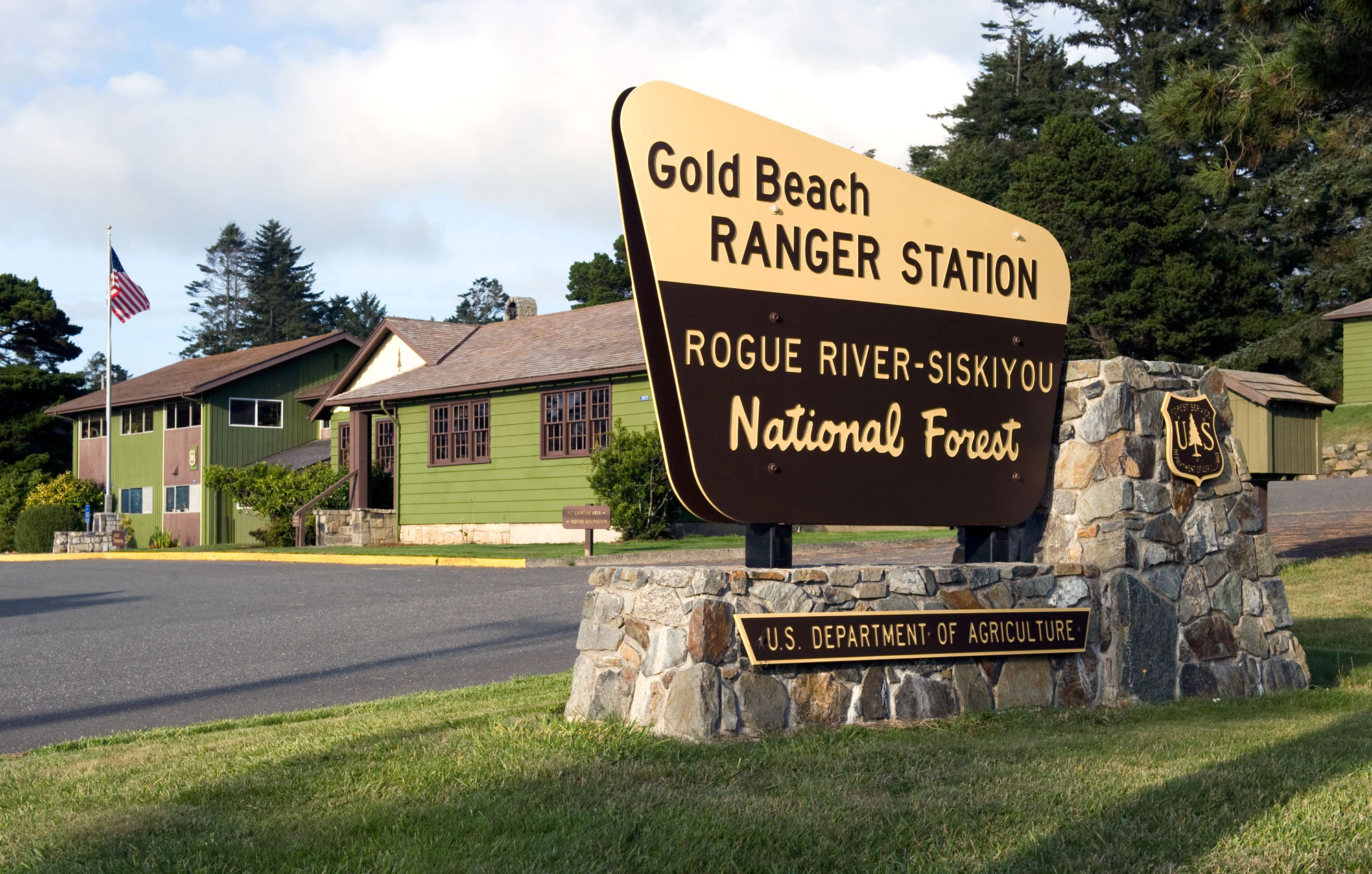
A large wooden park entrance sign reading Gold Beach Ranger Station and Rogue River-Siskiyou National Forest, mounted on a stone base, with green ranger station buildings in the background.
The entrance sign and historic buildings at the Gold Beach Ranger Station in Rogue River-Siskiyou National Forest.

Rogue River, Siskiyou National Forest ecosystems, habitats, and plant life

Rogue River–Siskiyou National Forest occupies a botanically rich transition zone between Oregon's interior forests and the more subtropical influences of coastal California. This overlap of climatic regimes produces a varied vegetation profile, ranging from dry conifer forests in the Cascades to moist, dense coastal forests near the Pacific.

Old-growth forest remains an important component of the natural landscape. Notable stands of Port Orford cedar and Douglas fir occur in the Copper Salmon Wilderness, with broader old-growth estimated across the forest in the early 1990s. Some of this old growth is concentrated in the Red Buttes Wilderness, contributing to the structural complexity and biodiversity of these protected areas.

The forest is also notable for occurrences of oak species that are otherwise more typical of California. Both blue oak, Quercus douglasii, and canyon live oak, Quercus chrysolepis, are found in the Siskiyou portion of the forest, with blue oak reaching the northern limit of its range here, no farther north than Del Norte County. These disjunct populations highlight the forest's role as an ecological bridge between the biota of California and the Pacific Northwest.

One biological superlative associated with the forest is the world's tallest pine tree, a ponderosa measuring 268.35 feet (81.79 meters). Such extreme specimens point to the favorable growing conditions and exceptional stand characteristics that occur in parts of the forest. At the same time, the forest's ecological history has been shaped by major disturbances, most notably the Biscuit Fire of 2002, which burned nearly 500,000 acres, including much of the Kalmiopsis Wilderness, leaving a lasting imprint on forest structure and regeneration patterns.

Rogue River, Siskiyou National Forest wildlife and species highlights

Because the Rogue River–Siskiyou National Forest spans Cascade, Klamath-Siskiyou, and coastal-range environments, its wildlife communities reflect a blending of inland mountain species, coastal forest species, and the aquatic fauna of the Rogue River and its tributaries. The forested corridors of the Cascades and the wetter coastal forests each provide habitat for different assemblages of mammals, birds, amphibians, and fish, while the rivers and their tributaries support salmon, steelhead, and other aquatic species that depend on cold, clean water and intact riparian forests.

The wilderness areas within the forest, especially the larger Kalmiopsis and Siskiyou Wilderness areas, provide some of the most secure habitat for species sensitive to human activity, supporting healthy populations of large mammals and raptors that rely on extensive unroaded backcountry. The combination of old-growth forest, varied topography, and a strong network of protected lands makes the forest ecologically important for both resident and migratory species.

Major disturbances have had significant impacts on wildlife habitat patterns over time. The Biscuit Fire of 2002 burned nearly 500,000 acres, affecting habitat across much of the Kalmiopsis Wilderness and adjacent areas, and the long-term ecological response of wildlife communities remains an important element of the forest's natural history.

Rogue River, Siskiyou National Forest conservation status and protection priorities

Rogue River–Siskiyou National Forest plays a significant role in regional conservation, both through its sheer size and through its concentration of protected wilderness. The forest contains all or part of eight separate wilderness areas, totaling roughly 565,900 acres, which form a substantial network of backcountry habitat across southwestern Oregon and northwestern California. These wilderness areas range from coastal environments in the Copper Salmon and Wild Rogue Wilderness areas to high-elevation terrain in the Sky Lakes and Rogue–Umpqua Divide Wilderness areas.

Conservation values within the forest include the protection of old-growth forest, particularly stands of Port Orford cedar and Douglas fir in the Copper Salmon area, and rare oak populations, including blue oak near the northern edge of its range. The forest's rivers, especially the Rogue and Illinois, have historically supported important anadromous fish runs, and the integrity of these river systems is a core conservation priority. Designation of the Wild Rogue Wilderness and protection along the Rogue River have reinforced this river-focused conservation network.

The forest has also been the focus of major restoration and post-fire management efforts following major wildfires. The Biscuit Fire of 2002, which burned almost 500,000 acres including much of the Kalmiopsis Wilderness, remains one of the defining conservation challenges in the forest, prompting long-term work to restore forest structure, reduce erosion risks, and protect aquatic ecosystems. In its modern administrative form, established in 2004 through the merger of the Rogue River and Siskiyou National Forests, the Rogue River–Siskiyou National Forest continues to serve as one of the cornerstones of federal conservation in the southern Oregon-northern California region.

Rogue River, Siskiyou National Forest cultural meaning and human context

The Rogue River–Siskiyou National Forest occupies a landscape with a long human history, layered over nineteenth-century American settlement, twentieth-century forest management, and earlier Indigenous presence throughout the river valleys and mountain ranges of southwestern Oregon and northwestern California. The naming of river valleys, ranger districts, and towns such as Ashland, Grants Pass, Jacksonville, and Gold Beach reflects the historic settlement and timber economies that shaped the modern communities surrounding the forest.

The wartime incident at Mount Emily in 1942 is among the more unique cultural-historical elements associated with the forest. As described by writer Stewart Holbrook in his essay "First Bomb," the Lookout Air Raid, in which bombs fell on the national forest, became a notable episode in the home-front history of World War II and is still recalled as part of the forest's broader human story.

In addition, the evolution of the forest itself, from the Ashland Forest Reserve of 1893 through the various consolidations that produced the Crater and Rogue River National Forests, and ultimately the 2004 merger into the Rogue River–Siskiyou National Forest, mirrors broader shifts in American forest policy and regional identity across more than a century.

Top sights and standout views in Rogue River, Siskiyou National Forest

The Rogue River–Siskiyou National Forest stands out for several distinctive qualities. It links three major mountain systems in a single protected landscape, the Cascade Range, the Klamath-Siskiyou Mountains, and the Southern Oregon Coast Range, creating one of the most physically varied national forests in the Pacific Northwest.

Eight designated wilderness areas make up a substantial portion of the forest, with the Kalmiopsis and Siskiyou Wilderness areas serving as major backcountry anchors. The presence of the world's tallest pine, extensive old-growth tracts, and disjunct populations of California oaks near their northern range limits further emphasize the forest's scientific and ecological value. At the same time, the Rogue River, one of the West's premier wild rivers, gives the forest both its name and much of its recreational identity.

Best time to visit Rogue River, Siskiyou National Forest

The Rogue River–Siskiyou National Forest experiences a Mediterranean-influenced climate with mild, wet winters and warm, dry summers. Summer and early fall are typically the most favorable seasons for exploring the forest's higher elevations, rivers, and wilderness trails, when snow has receded from most areas and river flows are generally lower and more predictable. Late spring can be beautiful in the Cascades, where mountain wildflowers and high-country creeks are prominent, though some higher trails and the Sky Lakes area can remain snowbound into early summer.

Winter brings cooler temperatures and periodic snowfall, especially in the Cascade portion of the forest, while the coastal Siskiyou area tends to remain wetter and milder year-round. The forest's broad elevational and climatic range means that visitors can find appealing conditions in different seasons depending on which part of this vast landscape they choose to explore.
Monthly climate preview

Long-term temperature ranges and monthly precipitation patterns across the protected landscape

Rogue River–Siskiyou National Forest Climate Normals and Weather by Month

Representative coordinates record measured monthly temperature swings from 3.8 degrees Celsius to nearly 20 degrees Celsius alongside shifting precipitation averages across the year. Detailed monthly climate normals provide a complete look at long-term meteorological patterns for Rogue River–Siskiyou National Forest.
Annual mean11 °C
4 °C20 °C
Jan
Feb
Mar
Apr
May11°
Jun15°
Jul20°
Aug20°
Sep17°
Oct12°
Nov
Dec
Warmest month
July

19.8 °C

Coolest month
December

3.8 °C

Wettest month
December

9.3 mm/day

Driest month
July

0.2 mm/day

Park location guide

Geography guide, regional context, and park location map for Rogue River, Siskiyou National Forest

Rogue River, Siskiyou National Forest park geography, regions, and map view in United States of America

Understand where Rogue River, Siskiyou National Forest sits in United States of America through a broader geographic reading of the surrounding landscape, nearby location context, and its mapped position within the national park landscape.

How Rogue River, Siskiyou National Forest fits into United States of America

The United States of America is a federal presidential republic and one of the world's largest countries by area and population. It consists of 50 states across a vast territory spanning multiple time zones, with its capital in Washington, D.C. and largest city in New York City. The nation has a diverse economy, influential political system, and significant cultural and military presence globally.

Wider geography shaping Rogue River, Siskiyou National Forest in United States of America

The United States occupies a vast territory in North America, bordered by Canada to the north and Mexico to the south. The 48 contiguous states stretch from the Atlantic to the Pacific Ocean, while Alaska occupies the northwestern region and Hawaii is an archipelago in the Pacific. The country encompasses diverse terrain including the Rocky Mountains, Appalachian Mountains, Great Plains, and extensive river systems.

Map view of Rogue River, Siskiyou National Forest

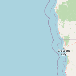
Use this park location map to pinpoint Rogue River, Siskiyou National Forest in United States of America, understand its exact geographic position, and read its mapped placement within the surrounding landscape more clearly.

Pigeon | © OpenStreetMap contributors

Location context for Rogue River, Siskiyou National Forest

CaliforniaOregon
Natural feature types

Explore the Natural Landmark Atlas of Rogue River–Siskiyou National Forest

Discover the specific named landforms and waterways situated across the expansive Rogue River–Siskiyou National Forest. This collection serves as a focused resource for understanding the regional geography and terrain distribution within the forest, mapping the physical elements that characterize this Pacific Northwest landscape.
Recorded earthquake history

Explore Recorded Earthquake History for the Rogue River–Siskiyou National Forest

Delve into the documented seismic history associated with this diverse mountain landscape. This collection provides an accessible view of historical earthquake records mapped to the Rogue River–Siskiyou National Forest for anyone interested in the regional geographic context.

Rogue River–Siskiyou National Forest Earthquake Records

Catalogued events

105 events

Strongest magnitude

Magnitude 6

Most recent event

Jan 27, 2026

This history includes earthquakes recorded inside the park or within 50 km of its borders

Visual reference of rugged mountain ranges, deep river canyons, and old-growth forest habitats.

Rogue River–Siskiyou National Forest Photos, Scenery, and Mapped Protected Landscapes

Visual documentation captures the varied terrain, steep river valleys, and distinct ecological zones spanning across the protected landscape. Examining actual park imagery helps observers understand the regional topography, habitat characteristics, and visual identity of the surrounding mountain ranges.

Close-up of a pine cone on a branch in the foreground, with an expansive mountain range featuring rocky slopes and patches of snow visible in the distance under a clear sky.

Two prominent, jagged rock pillars known as Rabbit Ears rise above a green, tree-covered mountainside under a clear blue sky.

A large wooden park entrance sign reading Gold Beach Ranger Station and Rogue River-Siskiyou National Forest, mounted on a stone base, with green ranger station buildings in the background.

Park atlas

Compare regional mountain ranges, forested river valleys, and connected Pacific Northwest wilderness areas.

Exploring Parks Near Rogue River–Siskiyou National Forest and Surrounding Protected Lands

Browsing other protected areas near Rogue River–Siskiyou National Forest reveals how rugged mountain ranges, dense old-growth forests, and wild river corridors span the Pacific Northwest. Comparing adjacent landscapes provides broader geographic context for the complex transition zones bridging the Cascade Range, Klamath Mountains, and coastal terrain.
National parkOregon
Park boundaries overlap#1 closest

Northeast

Crater Lake National Park: Oregon National Park Atlas of Volcanic Landscapes

Explore mapped boundaries and unique caldera geography.

Crater Lake National Park represents a significant protected area within Oregon, defined by the dramatic volcanic caldera it contains. This national park is celebrated for its exceptionally deep, clear blue lake, formed by the collapse of Mount Mazama, offering a unique subject for geographic and landscape study. Users can explore its mapped boundaries and understand its position within the broader atlas of protected lands and mountainous terrain of the Cascade Range.

Area
741.48 km²
Established
1902
IUCN
II
Visitors
527K annual
Wildlife reserveOregon
Park boundaries overlap#2 closest

North

Kalmiopsis Wilderness: Mapping the Protected Landscapes and Geology of Southwestern Oregon

Botanical richness and dramatic canyon terrain in the Klamath Mountains

Kalmiopsis Wilderness preserves a dramatic landscape of steep ridges and river-cut valleys across 180,000 acres in southwestern Oregon. Known for its distinct serpentine soils and high botanical diversity, the wilderness area offers a look at complex mountain ecology and significant Wild and Scenic River headwaters within the Rogue River-Siskiyou National Forest.

Area
727.44 km²
Established
1964
IUCN
Ib
Relief
Mountain
Wildlife reserveCalifornia
Park boundaries overlap#3 closest

East

Red Buttes Wilderness: Mapping the Protected Mountain Geography of the Siskiyou Range

A rugged wilderness reserve straddling California and Oregon

Red Buttes Wilderness preserves a complex mountainous terrain shaped by ancient metamorphic rocks and glacial history. The area features high ridgelines, alpine lakes, and specialized botanical habitats, providing a vital window into the ecological and geological diversity of the broader Klamath and Siskiyou mountain landscapes.

Area
80.7 km²
Established
1984
IUCN
Ib
Relief
Mountain
Wildlife reserveOregon
Park boundaries overlap#4 closest

Northeast

Rogue-Umpqua Divide Wilderness: Protected Ridge Landscape and Watershed Geography

High-country wilderness area in southwestern Oregon

Rogue-Umpqua Divide Wilderness preserves a dense, high-elevation ridge environment that separates the Rogue and Umpqua river drainages. Featuring a complex mix of volcanic and sedimentary rock outcrops within a continuous conifer canopy, the area offers a unique look at forest ecology in the Klamath Mountains. The geography provides extensive views across both watersheds and stands as a primary example of protected montane forest terrain within the Oregon landscape.

Area
134 km²
Established
1984
IUCN
Ib
Water
Minor water
Watercolor painting of a peaceful river landscape, featuring rolling green hills, dense trees, and distant soft-toned mountains.
Protected areaCalifornia
Park boundaries overlap#5 closest

South

Six Rivers National Forest: Exploring Protected River Valleys and Mountain Terrain in California

A regional protected area spanning California river systems

Six Rivers National Forest defines much of the rugged landscape in northwestern California. Named for the six major river drainages within its borders, the area features a unique combination of coastal forests, deep river canyons, and high-country ridges that offer significant insight into the region's broader geographic and ecological character.

Area
3,875.2 km²
Established
1947
Relief
Mountain
Climate
Mediterranean
A horizontal watercolor illustration showing a winding river flowing through a lush green valley with rolling hills in the background.
Protected landscapeCalifornia
Park boundaries overlap#6 closest

South

Smith River National Recreation Area: Mapping the Klamath Mountain Protected Landscape

Watershed geography and rugged mountain terrain in northwestern California

Located in the heart of the Klamath Mountains, Smith River National Recreation Area represents a critical protected watershed in northern California. The area is defined by its deep, forested canyons and the clean, wild waters of the Smith River, which serve as a primary link between coastal redwood ecosystems and mountainous inland terrain. Users can study the park boundaries and regional landscape characteristics that sustain this remote environment.

Area
1,235 km²
Established
1990
Relief
Mountain
Climate
Mediterranean
Wildlife reserveOregon
5.1 km away#7 closest

East

Mountain Lakes Wilderness: Geographic Atlas of Oregon's Glacial Volcanic Reserve

Mapping the volcanic cirques and square boundaries of the southern Cascades.

Mountain Lakes Wilderness serves as a primary geographic anchor in the southern Cascades, where shield volcanoes meet glacially carved basins. This protected area contains over twenty lakes situated in high-altitude cirques near the summits of volcanic peaks like Aspen Butte. The area is defined by its distinctive square survey-township boundary, providing a clear footprint of wilderness conservation within the larger Fremont-Winema National Forest terrain.

Area
93 km²
Established
1964
IUCN
Ib
Relief
Mountain
A watercolor illustration of rolling green hills, a small body of water, and distant mountain peaks against a plain white background.
Wildlife reserveOregon
6.4 km away#8 closest

Northeast

Mount Thielsen Wilderness: Protected Volcanic Terrain and Glacial Landscapes in Oregon

Southern Cascade Range mountain and forest geography

Mount Thielsen Wilderness offers a compact yet dramatic study of southern Cascade topography. Dominated by its signature lightning-struck volcanic peak, the area encompasses a complex network of glacial cirques, deep valleys, and high-altitude forest zones. This map-rich entry point provides a closer look at the protected boundaries and natural geological features that define this significant segment of Oregon wilderness.

Area
223 km²
Established
1984
IUCN
Ib
Relief
Mountain

Common questions about visiting, size, designation, and location context for Rogue River, Siskiyou National Forest

Rogue River, Siskiyou National Forest FAQs for park facts, access, geography, and protected area context

Find quick answers about Rogue River, Siskiyou National Forest, including protected-area facts, park geography, trail and visitor context, and how the park fits into its surrounding country and regional landscape.
MoriAtlas Explorer

Continue Your Protected Areas Search Across the Global Atlas

Deepen your exploration by continuing the structured search for national parks and protected areas worldwide. Utilize the comprehensive filtering capabilities to compare different conservation landscapes and refine your understanding of global park geography. Discover more about the distribution and characteristics of protected natural areas.

Global natural geography