
Mori Atlas logo
Natural monumentRoseggletscher

A detailed map and geographic profile of the valley glacier system and its proglacial lake.

Roseggletscher Natural Monument: Exploring Alpine Glacier Landscapes in Graubünden, Switzerland

The Roseggletscher represents a significant high alpine landscape in the Bernina range, characterized by its dramatic twentieth century retreat and the formation of the Lej da Vadret. This natural monument illustrates complex glacial dynamics within the Graubünden region, where historical maps and ongoing landscape change reveal the evolution of ice tongues, lateral moraines, and proglacial drainage systems. Observe the topographic setting of this valley glacier as it descends from the Italian Swiss border.

glaciervalley glacierBernina rangeSwiss AlpsGraubündenproglacial lake
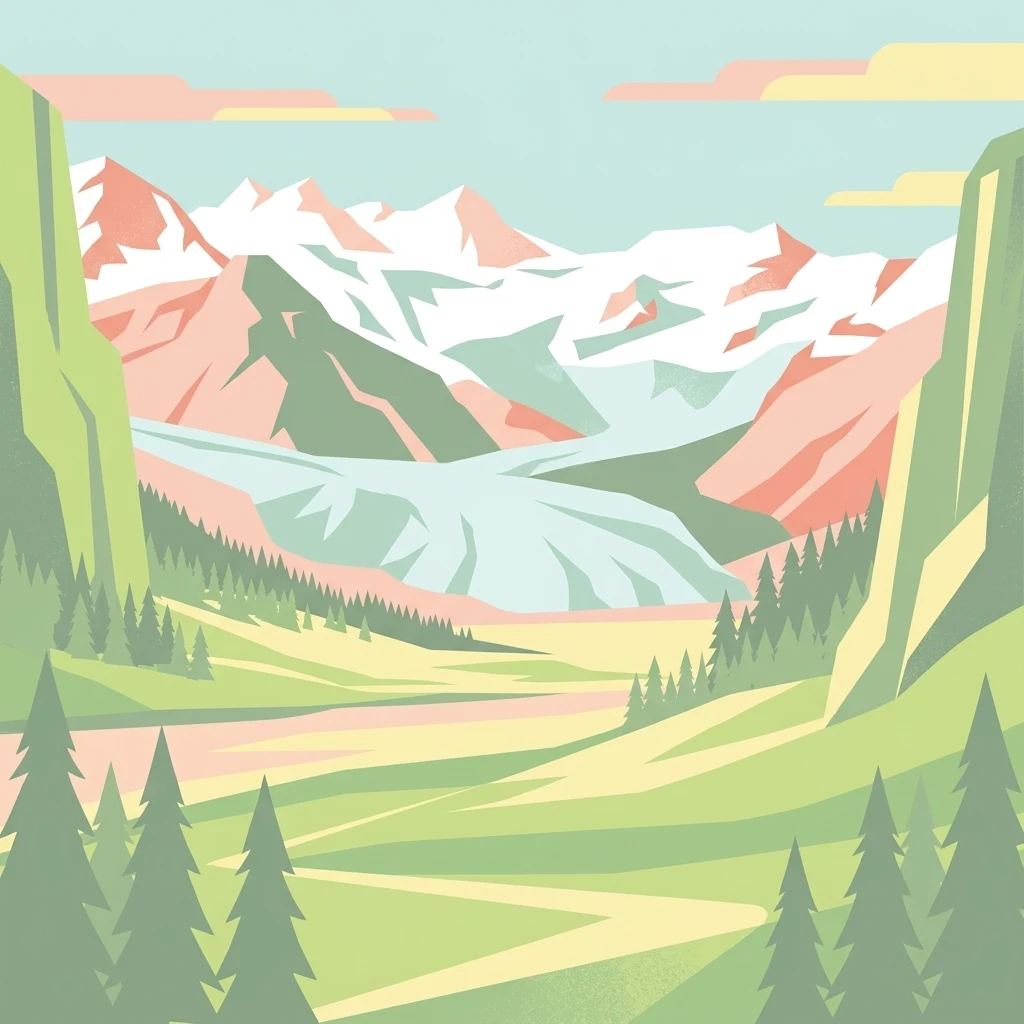
A flat-style digital illustration of an alpine valley featuring a glacier in the background; evergreen trees line the base of rocky slopes leading into a mountain pass.

Roseggletscher

Natural monument

Park overview

Structured park overview, official facts, and landscape profile for Roseggletscher

Roseggletscher park facts, protected area profile, and essential visitor context

Review the core facts for Roseggletscher, including designation, size, terrain, visitor scale, habitats, and operating context in one park-focused overview.

About Roseggletscher

The Roseggletscher occupies a deeply carved northern cirque of the Bernina range, in a part of the Swiss Alps where glaciers still descend close to the forested valley floor. Its accumulation zone clings to high rocky ridges that form part of the international border with Italy, while its tongue pours downward into the head of the Val Roseg, a celebrated side valley of the Upper Engadin.

Glaciological work has documented the Roseggletscher as a modest but thoroughly studied valley glacier. Modern inventories place its length in the low single digits of kilometres and its area in the mid-single-digit square kilometres, confirming that it is far smaller than the great Morteratsch glacier that descends the next valley to the east, yet still substantial enough to be treated as an independent ice body rather than a remnant of one. Its volume, like that of most Alpine glaciers, is small relative to its surface area, reflecting the steep, narrow valley it occupies.

The glacier's identity is inseparable from its hydrological and visual setting. Its meltwater feeds the Rosegbach (Ova da Roseg), a mountain torrent that flows into the Flaz and onward to the Inn; its tongue sits beside the Lej da Vadret, a narrow proglacial lake; and its flanks frame hiking routes between the Val Roseg and the SAC's Chamanna Coaz hut. In this sense the Roseggletscher is less a destination on its own than a central visual and ecological element of an entire Bernina valley landscape, where ice, water, moraines, and high alpine ridges combine into a single coherent scenery.

Quick facts and research context for Roseggletscher

The Roseggletscher is a northward-exposed valley glacier in the Bernina group of the canton of Graubünden. Its accumulation area lies above roughly 3500 m above sea level along the border ridge between Switzerland and Italy, near Piz Glüschaint and the rock crest known as I Gemelli.

The glacier drains north into the Val Roseg. Its meltwater joins the Rosegbach, then the Flaz and eventually the Inn. It functions today as a relatively small but independently mapped Alpine glacier, in contrast to the larger and more frequently photographed Morteratsch and Pers glaciers in the same massif.

Protection and recognition

Analysis of terrestrial protected area designation and recognition records

Roseggletscher Protection Status and Documented Conservation Scope

Roseggletscher encompasses a defined terrestrial protection scope within the regional conservation network. Documented regulatory records provide baseline metrics for international recognition and administrative oversight.

Protection details

Protection scope
Terrestrial
Transboundary protection
No
Park context

Deeper park guide and search-rich context for Roseggletscher

Roseggletscher history, landscape, wildlife, and travel context

Explore Roseggletscher through its history, landscape character, ecosystems, wildlife, conservation priorities, cultural context, and seasonal travel timing in a structured park guide built for atlas discovery and search intent.

Why Roseggletscher stands out

The Roseggletscher is best known for its dramatic twentieth-century retreat and for the proglacial lake, the Lej da Vadret, that formed between its tongue and that of the neighbouring Tschiervagletscher when the two ice bodies finally separated in the mid-twentieth century. It is also valued as part of the wider Bernina glacier ensemble accessible from the Upper Engadin: a compact valley system where multiple glaciers (Roseg, Sella, Tschierva, Morteratsch, Pers, Cambrena, and Palü) drain nearby peaks and where the long-term historical record, sketched on the Dufour map of 1866 and the Siegfried map of 1877, makes landscape change unusually legible to visitors.
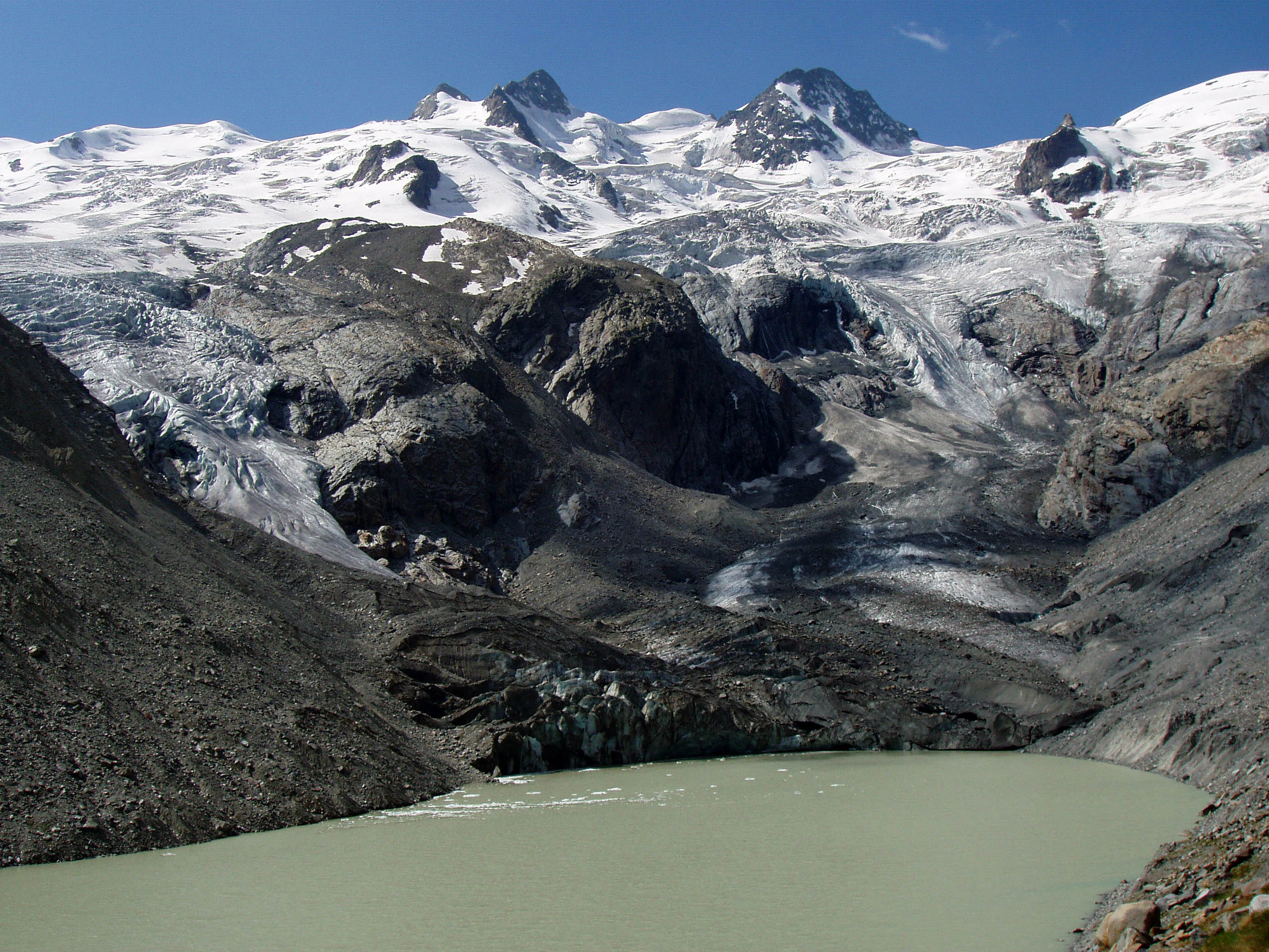
Vadret da Roseg
View of the Italian-Swiss Sella Ridge featuring the Sella Glacier and Roseg Glacier, including the peaks I Gemelli, La Sella, Piz Gluschaint, and La Muongia.

Roseggletscher history and protected-area timeline

The Roseggletscher first appears in systematic cartographic form on the Dufour map of 1866, which already shows it as part of a continuous system of Bernina glaciers stretching across the range. The Siegfried map of 1877 captures the Roseg- and Tschiervagletscher together, when their tongues still merged near the present-day Hotel Roseg.

During the Little Ice Age, the Roseg- and Tschiervagletscher reached far lower into the Val Roseg than they do today. From roughly the mid-nineteenth century onward, both glaciers retreated substantially. By the early twentieth century, around 1900, visitors to the Roseg hotel could still photograph the two ice fronts joining; by the mid-twentieth century the separation was complete.

The retreat was not merely a slow decline. In August 1954, a rapid rise in the level of the Lej da Vadret, fed by meltwater and heavy rains, caused severe local erosion at the lake's outflow. The resulting flood pulse travelled down the Rosegbach, Flaz, and Inn and contributed to the major flood damage experienced in the Upper Engadin that summer. Since then, repeated measurements have continued to record shrinkage in both surface area and length, leaving the Roseggletscher with less than half of its nineteenth-century footprint.

Roseggletscher landscape and geographic character

The Roseggletscher lies in a classic Alpine U-shaped valley setting. Its head is a high, broken rock ridge running between roughly 3500 m peaks along the Swiss-Italian border, dominated by Piz Glüschaint and the twin peaks known as I Gemelli, with the ice spilling over into the adjacent Sellagletscher basin near Piz Roseg and Piz Sella. From there the flowing ice drops steeply into a narrower valley where crevasses interrupt the smooth surface and lateral moraines begin to build along its flanks.

At its lower end, the tongue of the glacier terminates above a narrow basin now occupied by the Lej da Vadret, an elongated proglacial lake roughly 1500 m long and 300 m wide. The lake is bordered on one side by the decaying ice of the Roseggletscher, and on the other by the older, partly vegetated lateral moraine that once marked the junction with the Tschiervagletscher. The Rosegbach leaves the lake through an eroded outlet channel and descends rapidly toward the forested floor of the Val Roseg.

The surrounding scenery combines icy cirques, polished rock, scree, moraines, meltwater streams, and the dark coniferous slopes typical of the Upper Engadin. From the valley, the glacier is seen in context rather than as an isolated white streak; it forms part of a layered landscape that draws the eye from lake to moraine to ice to ridge.
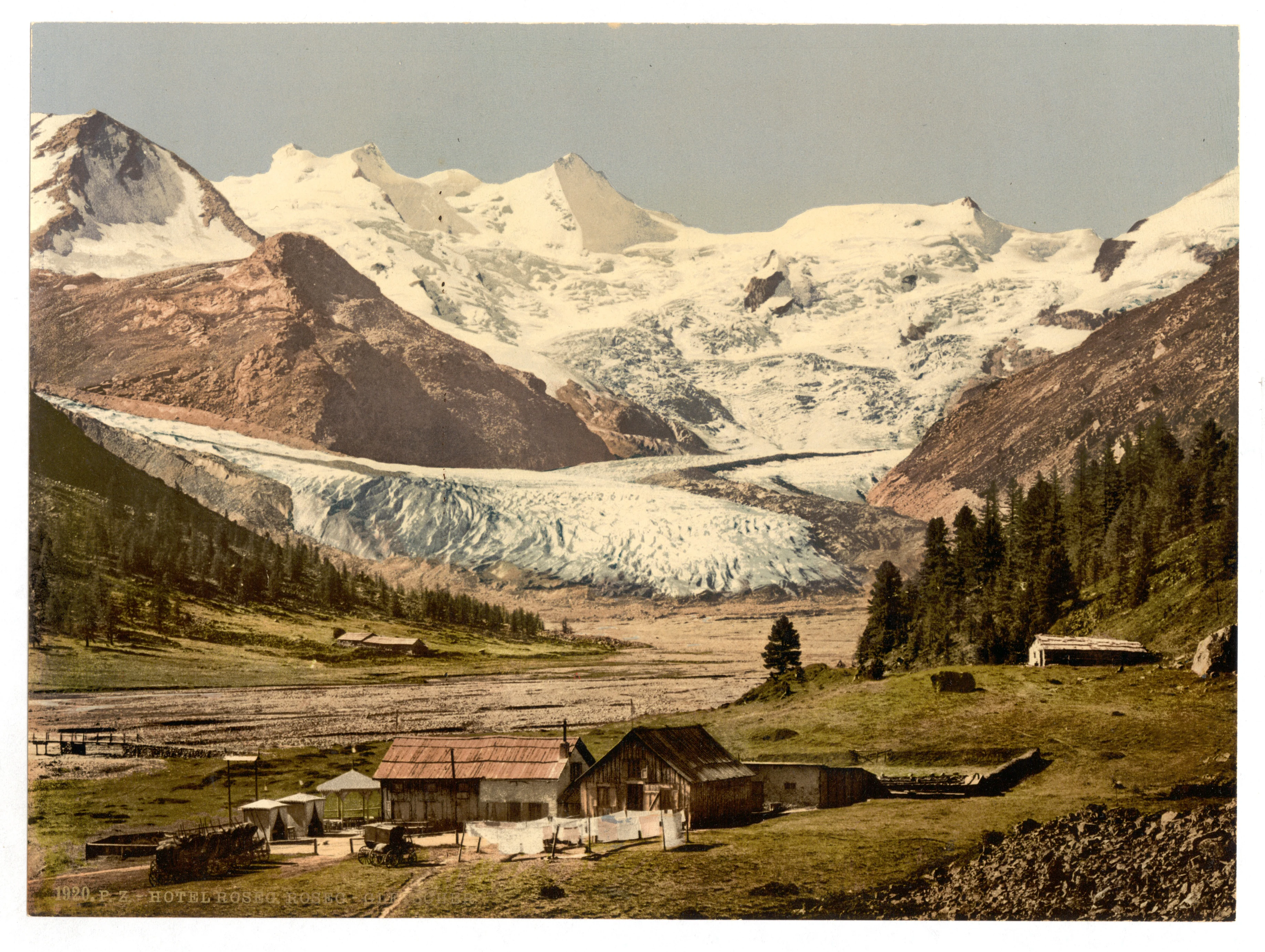
A vintage colorized image showing a large glacier flowing down from snow-capped mountains into a valley, with wooden buildings in the foreground.
A historic 1905 photochrom view of the Roseg Glacier and mountain buildings in the Upper Engadine region.

Roseggletscher ecosystems, habitats, and plant life

Ecologically, the Roseggletscher defines a high-alpine environment in which ice and recently deglaciated terrain dominate. Its surroundings include a wide spectrum of cold-climate habitats: bare rock, fresh moraines, snowfields, alpine meadows, and the encroaching subalpine forest that climbs the lower walls of the Val Roseg.

The glacier itself is a zone where life is sparse and largely microbial or invertebrate, with cold-tolerant mosses, lichens, and pioneer plants establishing themselves on newly exposed moraine deposits. The Lej da Vadret and the outflowing Rosegbach add aquatic and riparian habitats to the mosaic, while the surrounding slopes support the typical Upper Engadin mixture of larch and Swiss stone pine forests, alpine grasslands, and krummholz. Across the broader Bernina massif, these varied altitudinal bands create the conditions for the area's well-known biodiversity, even though the glacier surface itself contributes relatively little to that biological richness.

Roseggletscher wildlife and species highlights

The Roseggletscher lies in an area where large mammals, characteristic alpine birds, and small cold-adapted species are the most visible forms of wildlife. The surrounding Bernina valleys are known to host ibex, chamois, marmots, and red deer, while the rocky ridges and the lake margins support raptors such as golden eagles and, where conditions permit, bearded vultures.

Birdlife along the Lej da Vadret and the Rosegbach includes typical species of high-altitude running water and proglacial lakes, while alpine meadows above the glacier attract ground-nesting passerines during the short summer. Conservation interest is less about the glacier itself than about the corridors of connected habitat it leaves behind as it retreats, since its disappearance reshapes movement routes and vegetation patterns across the Bernina landscape.

Roseggletscher conservation status and protection priorities

Like other glaciers in the Bernina group, the Roseggletscher serves as both a climate indicator and a hydrological reserve. Its long and well-documented retreat, captured on successive Swiss maps from the Dufour map of 1866 to modern inventories, makes it a useful natural record of post-Little-Ice-Age warming in the Alps. Its meltwater remains significant for the downstream Rosegbach, Flaz, and Inn system, especially during hot, dry summers when low-elevation tributaries contribute little.

The proglacial environment it is leaving behind, including the Lej da Vadret and the freshly deglaciated moraines, is also of incidental conservation interest, since such newly exposed terrain offers early-successional habitats that have become increasingly rare in heavily glaciated regions. The broader setting, near the Swiss National Park and within a network of protected and traditionally managed Alpine valleys, reinforces the area's value for landscape-scale conservation in the eastern Swiss Alps.

Roseggletscher cultural meaning and human context

The area around the Roseggletscher sits within the Romansh-speaking heartland of Graubünden, and its local name, Vadret da Roseg, reflects that heritage. The valley's traditional economy has long combined summer alpine pastoralism with the early development of mountain tourism, rooted in places like the Hotel Roseg that became a base for excursions onto the glaciers in the late nineteenth and early twentieth centuries.

Mountaineering also defines part of the area's cultural identity. The Chamanna Coaz, a hut of the Swiss Alpine Club at roughly 2610 m on the slopes west of the glacier, bears the name of Johannes Coaz, a notable early Swiss alpinist and surveyor, and continues the tradition of alpine exploration that shaped the Bernina's reputation. Photographs and paintings from the late nineteenth and early twentieth centuries, such as the views taken around 1900 from the Hotel Roseg, reflect the period when glaciers themselves became objects of aesthetic and scientific fascination.

Top sights and standout views in Roseggletscher

The Roseggletscher's stand-out qualities include the dramatic long-term retreat visible in successive maps and photographs since the Little Ice Age, the proglacial lake Lej da Vadret that formed when it separated from the Tschiervagletscher, and its intimate setting within the high-lying Bernina valley landscape.

It is also notable for the unusually complete cartographic record that surrounds it, from the Dufour map of 1866 to the most recent aerial and satellite surveys, which makes it possible to reconstruct its shrinkage in unusual detail.

Best time to visit Roseggletscher

Because the Roseggletscher is a high-altitude glacier reached via a side valley of the Upper Engadin, summer and early autumn are the most useful seasons for visits. The walking routes through the Val Roseg, the viewpoints over the Lej da Vadret, and the approach to the Chamanna Coaz are generally accessible only when the valley has thawed, the lake and moraines are clearly visible, and snow cover on the surrounding ridges has thinned.

Outside this window the area becomes deeply snowbound, with snow covering both the tongue of the glacier and the lake basin, eliminating the visual contrast that gives the landscape its character. Visitors interested in observing the retreat of the ice, in particular the relationship between the glacier and the Lej da Vadret, will find late summer to early autumn the most informative period, when recent ice loss from the season is freshest.

Monthly climate preview

Long-term representative coordinate records for temperature and precipitation rhythm

Roseggletscher Climate Normals and Measured Annual Temperature Patterns

Representative coordinates record measured monthly temperature swings alongside precipitation rates from nineteen ninety-one to twenty twenty. Examining complete monthly climate normals reveals full seasonal variations across high alpine elevations.
Annual mean0 °C
-10 °C11 °C
Jan-10°
Feb-10°
Mar-6°
Apr-1°
May
Jun
Jul11°
Aug10°
Sep
Oct
Nov-4°
Dec-9°
Warmest month
July

10.6 °C

Coolest month
January

-10.1 °C

Wettest month
June

4.4 mm/day

Driest month
February

1.5 mm/day

Park location guide

Geography guide, regional context, and park location map for Roseggletscher

Roseggletscher park geography, regions, and map view in Switzerland

Understand where Roseggletscher sits in Switzerland through a broader geographic reading of the surrounding landscape, nearby location context, and its mapped position within the national park landscape.

How Roseggletscher fits into Switzerland

Switzerland is a landlocked federal republic in Central Europe comprising 26 cantons, with Bern as the federal city and Zurich as the largest city. The country features the Swiss Alps, Swiss Plateau, and Jura Mountains, with German, French, Italian, and Romansh as official languages. It is noted for its political neutrality, direct democracy traditions, and strong economy.

Wider geography shaping Roseggletscher in Switzerland

Switzerland is located in Central Europe at the intersection of Western and Southern Europe. It is bordered by Germany to the north, France to the west, Austria and Liechtenstein to the east, and Italy to the south. The country is geographically divided among the Swiss Alps (covering most of the territory), the Swiss Plateau (where most of the population resides), and the Jura Mountains. Switzerland is landlocked.

Map view of Roseggletscher

Use this park location map to pinpoint Roseggletscher in Switzerland, understand its exact geographic position, and read its mapped placement within the surrounding landscape more clearly.

Pigeon | © OpenStreetMap contributors

Location context for Roseggletscher

Graubünden

Explore photographic records of ice tongues, proglacial lakes, and high mountain terrain.

Roseggletscher Photos and Alpine Scenery: Visualizing the Bernina Glacier Landscape

Visual documentation of Roseggletscher reveals rugged U-shaped valleys, retreating ice tongues, and proglacial lakes formed along the Bernina range. Examining these protected-area photographs provides a clearer understanding of alpine terrain, glacial retreat, and surrounding mountain habitats.

Vadret da Roseg

A wide angle view of the massive snow and ice covered Roseggletscher surrounded by dark rocky alpine mountain peaks under a clear blue sky.

A vintage colorized image showing a large glacier flowing down from snow-capped mountains into a valley, with wooden buildings in the foreground.

Park atlas

Discover adjacent Alpine valleys and connected regional glacier landscapes

Explore Protected Areas and Parks Near Roseggletscher

Browse nearby protected landscapes and alpine valley environments connected to the Bernina range. Comparing adjacent glacial terrain reveals wider patterns of high-altitude retreat across the surrounding region.
Nature reserveLombardia
About 20 km away#1 closest

Southwest

Val di Mello Nature Reserve: Mapping the Granitic Geography of the Italian Alps in Lombardia

A study of protected vertical relief, glacial cirques, and Alpine terrain.

Val di Mello offers a profound look at high-altitude Alpine geography, characterized by its immense, light-colored granitic walls and deeply carved tributary valleys. This protected nature reserve acts as a gateway to the broader mountainous terrain of the Lombardia region, showcasing the geological evolution of the Italian Alps through its steep gullies, high summits, and expansive valley floor.

Established
2009
Relief
Mountain
Access
Moderate access
Scope
Terrestrial
A soft watercolor painting of a river winding through a valley with green trees, grassy plains, and distant purple hills against a white background.
Nature reserveGraubünden
About 21 km away#2 closest

North

Naturschutzgebiet Isla Glischa-Arvins-Seglias Nature Reserve in Graubünden

Mapped alluvial terrain and alpine river geography

Situated in the broad valley floor of the Upper Engadin, this nature reserve protects one of the most significant alpine floodplain zones in the Swiss canton of Graubünden. The area features a complex network of river channels, gravel lakes, and marshes that are currently undergoing active revitalization to restore natural riverine processes and support rare riparian ecosystems.

Area
0.867 km²
Established
1992
IUCN
IV
Relief
Upland
Watercolor illustration of a panoramic mountain landscape with soft green hills, rolling ridgelines in shades of pink and purple, and small patches of blue water in the foreground.
Regional parkCanton of Graubünden
About 27 km away#3 closest

Northwest

Parc Ela: Regional Nature Park and Alpine Geography in the Canton of Graubünden

A vertical protected landscape in the Swiss Alpine arc.

Parc Ela encompasses a remarkable span of Swiss Alpine geography, protecting everything from low-lying forested gorges at seven hundred meters to high-altitude peaks over three thousand meters. The park serves as a vital refuge for threatened insect species and large alpine mammals, while preserving the linguistic and architectural heritage of the Albula and Oberhalbstein valleys. Explore the mapped terrain where paleontological treasures meet historic trade routes.

Area
659 km²
Established
2012
Relief
Mountain
Climate
Alpine
Regional parkGraubünden
About 27 km away#4 closest

Northwest

Naturpark Beverin: Exploring Alpine Gorges and Cultural Landscapes in Graubünden

A regional nature park shaped by high alpine ridges and ancient settlement traditions.

Naturpark Beverin encompasses a vast, multi-layered environment in the Swiss Alps. The area is defined by the sharp vertical contrast between carved river gorges like the Viamala and high-elevation ridges. Beyond the rugged mountain terrain, this protected landscape preserves centuries of pastoral history through the distinct settlement traditions of its Romanesque and Walser valleys.

Area
515 km²
Established
2013
Relief
Mountain
Climate
Alpine
National parkGraubünden
About 29 km away#5 closest

Northeast

Swiss National Park: Geographic Context and Protected Alpine Wilderness in Graubünden

A comprehensive look at the Engadin valley's premier wilderness sanctuary

Spanning over 170 square kilometers in the canton of Graubünden, the Swiss National Park offers an unparalleled example of a strictly protected Alpine ecosystem. This atlas profile details the park's distinct topography, from the subalpine pine forests near the Ofenpass to the delicate karst lake basins at Macun, providing a deep look into its history as a central reference site for wilderness restoration and geological research.

Area
170.3 km²
Established
1914
IUCN
Ia
Relief
Mountain
Watercolor painting of a mountain range with a lake, green hills, and a sunset sky
National parkTrentino-Alto Adige/Südtirol
About 29 km away#6 closest

East

Stelvio National Park National Park: Protected Landscape and Regional Geographic Context

Explore its mapped boundaries and natural terrain.

Navigate Stelvio National Park, a designated national park in Italy's Trentino-Alto Adige/Südtirol region, through a map-centric lens. This page provides critical context for understanding the park's protected landscape, its geographic position within the Alps, and its mapped terrain. Utilize MoriAtlas to grasp the park's boundaries and its place in regional geography for structured natural landscape discovery.

Established
1935
IUCN
II
Relief
Mountain
Scope
Terrestrial
A soft watercolor painting showing a wide, high-altitude alpine plateau with rolling hills, scattered small lakes, and distant mountain ridgelines.
Nature reserveGraubünden
About 45 km away#7 closest

Northeast

Macun-Seen Nature Reserve: Protected Alpine Plateau and Cirque Lake Landscape

High-altitude basin and crystalline geological features in Graubünden

Located in the Lower Engadine region of Graubünden, the Macun-Seen nature reserve is a significant high-altitude basin formed by glacial action. This protected exclave contains 23 small cirque lakes across a silicate plateau, offering a distinct ecological profile and expansive views of peaks approaching 3000 metres. It stands as a prime example of preserved alpine terrain within the broader Swiss National Park context.

Area
3.6 km²
Established
2000
Relief
Mountain
Climate
Alpine
A soft, horizontal watercolor painting showing rolling green hills, a winding river or lake, and misty mountain silhouettes in the background against a white backdrop.
Regional parkGraubünden
About 48 km away#8 closest

Northeast

Biosfera Val Müstair Regional Park: Alpine Landscapes and UNESCO Biosphere Geography

Protected glacial terrain and cultural alpine valleys in eastern Switzerland.

Discover the distinctive natural geography of Biosfera Val Müstair, where a dry inner-Alpine climate meets high-altitude glacial features like the Lai da Rims. This regional park protects an extensive area of Graubünden, balancing rare ecosystems, broad alluvial fans, and the traditional alpine economy of the Romansh-speaking community.

Area
198.65 km²
Established
2011
Relief
Mountain
Climate
Alpine

Common questions about visiting, size, designation, and location context for Roseggletscher

Roseggletscher FAQs for park facts, access, geography, and protected area context

Find quick answers about Roseggletscher, including protected-area facts, park geography, trail and visitor context, and how the park fits into its surrounding country and regional landscape.
MoriAtlas Explorer

Continue Your Protected Areas Search Across the Global Atlas

Deepen your exploration by continuing the structured search for national parks and protected areas worldwide. Utilize the comprehensive filtering capabilities to compare different conservation landscapes and refine your understanding of global park geography. Discover more about the distribution and characteristics of protected natural areas.

Global natural geography