
Peaks
Park geography
Analyzing the park terrain, riverine systems, and forest landscapes within regional boundaries
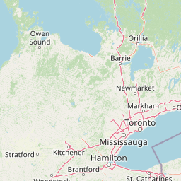
Detailed Geographic Profile and Mapped Boundaries of Rouge National Urban Park in Ontario
Review the geographic framework of Rouge National Urban Park, which spans 79.1 square kilometers of mixed terrain in Ontario. This profile documents essential landscape features including the Rouge River, diverse forest covers, and various creek systems within its established boundaries.
Related tags
urban parkwetlandsriver valleyprotected areaGreater Toronto Area
North America's largest urban protected area, spanning from Lake Ontario to the Oak Ridges Moraine
Rouge National Urban Park
Rouge National Urban Park is a national urban park in Ontario, Canada, situated within the Greater Toronto Area. The park is centred around the Rouge River and its tributaries, stretching from the river's mouth at Lake Ontario in the south northward into the municipalities of Markham, Pickering, Uxbridge, and Whitchurch-Stouffville. Established under the Rouge National Urban Park Act in May 2015, it became the largest urban protected area in North America, covering approximately 79 square kilometres of diverse terrain including forests, wetlands, farmland, and river valleys. The park represents a significant conservation achievement, preserving ecological integrity within one of Canada's most densely populated metropolitan regions while providing accessible natural experiences for millions of urban residents.
- Location
- Canada
- Park type
- National park
- Established
- 2015
- Area
- 79.1 km²
Location overview
Regional placement and coastal conservation status in Canada
Geographic Setting of Rouge National Urban Park in Ontario
Rouge National Urban Park is located within the province of Ontario in Canada. Factual records classify the protected area as a coastal park rather than an island or marine landscape.
- Countries
- Canada
- Regions
- Ontario
- Primary location
- Ontario
- Geographic setting
- Coastal
Boundary and coordinates
Interactive boundary geometry, coordinate limits, and area metrics
Rouge National Urban Park Boundary Map and Geographic Extent
Mapped park outlines provide spatial context for exploring territorial limits and regional boundaries. Associated geographic facts detail calculated area metrics, spatial spans, and coordinate centres.
- Boundary area
- 78.6 km²
- Boundary perimeter
- 90.6 km
- Northernmost point
- 43.9951° N
- Southernmost point
- 43.7898° N
- Easternmost point
- 79.1148° W
- Westernmost point
- 79.2666° W
- Geographic centre
- 43.9014° N, 79.1987° W
- North–south span
- 22.8 km
- East–west span
- 12.2 km
Elevation and terrain
Mixed relief topography and recorded internal natural features
Rouge National Urban Park Elevation and Terrain Profile
Recorded elevation records place the minimum baseline at 74 meters within a mixed relief landscape. Linked feature cards supply names, types, measurements, and spatial relationships for streams, peaks, and valleys.
- Minimum elevation
- 74 m
Selected named natural features
Streams
Wixon Creek
Streams
Major Creek
Viewpoints
Vista Trail Viewing Platform
Valleys
Rouge Valley
Streams
Little Rouge Creek
Environmental setting
Temperate climate zones, mixed relief, and riverine habitat designations
Rouge National Urban Park Environmental Classifications and Physical Setting
Recorded landscape features, habitat types, and water presence classifications provide structured categories for reading the physical setting of Rouge National Urban Park. Stored properties connect each environmental classification to relevant atlas destinations across the protected area.
- Relief
- Mixed relief
- Climate
- Temperate
- Water
- Major water bodies
- Forest cover
- Partial forest
- Seasonality
- Year-round
Landscape features
Rivers · Valleys · Forest · Wetland · Cliffs · Coast · Grassland · Hills
Habitat types
Riverine habitat · Wetland · Temperate broadleaf forest · Coastal habitat · Grassland
Park atlas
Explore connected protected landscapes and regional park geography around Canada's largest urban park.
Discover Other National Parks and Protected Areas Near Rouge National Urban Park in the Greater Toronto Region
Explore additional national parks and protected areas in the surrounding Ontario region, tracing diverse landscapes from urban green spaces to glacial landforms and river valleys. Compare different conservation landscapes and their geographic spread within the Greater Toronto Area, offering valuable context for regional park discovery.
National parkOntario
104 km away#1 closest
Northwest

Georgian Bay Islands National Park: Ontario National Park Protected Landscape Atlas
Explore mapped boundaries and regional geographic context.
Gain a comprehensive understanding of Georgian Bay Islands National Park as a distinct protected area within Ontario. This entry provides detailed geographic context, focusing on the park's mapped landscape, its protected status as a national park, and its position within the regional geography of Canada. It is designed for users seeking structured information about protected lands and their atlas-level significance.
- Area
- 13.5 km²
- Established
- 1929
- IUCN
- II
- Visitors
- 27.5K annual
Wildlife reserveOntario
About 111 km away#2 closest
North
Eleanor Island Wildlife Reserve: Protected Ontario Lake Landscape and Bird Habitat
A federal migratory bird sanctuary in the Canadian Shield
Eleanor Island is a strictly protected migratory bird sanctuary in Ontario that serves as a vital nesting ground for colonial waterbirds. Positioned within Lake Muskoka, this small but ecologically purposeful nature reserve demonstrates the importance of localized federal protection for regional breeding populations. Its status as a strict nature reserve underscores a commitment to safeguarding sensitive habitats within the broader Canadian Shield wilderness.
- Area
- 0.006 km²
- Established
- 1978
- IUCN
- Ia
- Relief
- Lowland
Wildlife reserveOntario
About 124 km away#3 closest
East
Wellers Bay National Wildlife Area: Coastal and Island Geography in Ontario
An important Great Lakes barrier beach protected reserve
Wellers Bay National Wildlife Area contains a rare collection of undeveloped shorelines, including the Baldhead peninsula and offshore islands. This protected area offers a deep look into the littoral processes of Lake Ontario, providing crucial sanctuary for waterbirds and endangered species within a fragile, compact, and natural woodland environment.
- Area
- 0.74 km²
- Established
- 1978
- IUCN
- Ia
- Scope
- Terrestrial
Wildlife reserveOntario
About 181 km away#4 closest
East
Prince Edward Point National Wildlife Area: Protected Geography and Migration Hub
Coastal woodland and shoreline terrain in southeastern Ontario
Prince Edward Point National Wildlife Area is a federal reserve located on a narrow peninsula extending into Lake Ontario. This area features a diverse landscape of forest patches, open meadows, and jagged lakefront, providing critical refuge for migrating bird species. As a long-standing center for ornithological research, the site remains an essential node for understanding the regional migration patterns and natural heritage of the Great Lakes basin.
- Area
- 5.6 km²
- Established
- 1980
- IUCN
- Ia
- Relief
- Lowland
Marine protected areaNew York
About 195 km away#5 closest
East

Lake Ontario National Marine Sanctuary: Geographic Atlas and Protected Area Overview
Mapping freshwater maritime heritage and coastal New York landscapes.
Spanning the southeastern waters of Lake Ontario, this marine protected area safeguards dozens of historic shipwrecks and vital Indigenous cultural sites. This atlas entry provides geographic context on the sanctuary boundaries, submerged archaeological zones, and the surrounding New York freshwater environment.
- Area
- 4,460 km²
- Established
- 2024
- IUCN
- V
- Relief
- Lowland
Protected landscapePennsylvania
199 km away#6 closest
South
Allegheny National Forest: Geographic Analysis and Protected Landscape Mapping in Pennsylvania
Rolling plateau topography and expansive hardwood forest conservation zones.
Covering over half a million acres in northwestern Pennsylvania, Allegheny National Forest represents a pivotal protected landscape east of the Mississippi. This overview focuses on the intersection of even-aged timber management, old-growth hemlock stands, and the hydrology of the Allegheny Reservoir. Examine the forest's varied terrain, from ridgelines to riverine islands, through a lens of regional conservation and mapped environmental data.
- Area
- 2,076.75 km²
- Established
- 1923
- Relief
- Upland
- Climate
- Temperate
National parkOntario
200 km away#7 closest
East
Thousand Islands National Park: Exploring Ontario's Protected Landscape Geography
Discover the mapped terrain and regional context of this national park.
Uncover the protected landscape identity of Thousand Islands National Park, a key national park located in Ontario. This resource focuses on its geographic setting, mapped boundaries, and overall atlas context, providing a clear understanding of its role as a protected area. Explore how its unique terrain contributes to the regional geography and the broader national park network, offering valuable insight for landscape-focused discovery.
- Area
- 24.4 km²
- Established
- 1904
- IUCN
- II
- Visitors
- 109.3K annual
National parkOntario
217 km away#8 closest
Northwest
Bruce Peninsula National Park: National Park Protected Landscape and Geographic Context in Ontario
Discover its mapped boundaries and regional landscape identity.
Bruce Peninsula National Park stands as a protected national park entity within Ontario, offering a distinct geographic profile. Its mapped boundaries and position within the regional atlas are crucial for understanding its landscape character. MoriAtlas facilitates exploration of the park's protected status and its contribution to the conservation landscape of Ontario.
- Area
- 154 km²
- Established
- 1987
- IUCN
- II
- Visitors
- 460.4K annual
MoriAtlas Explorer
Continue Your Atlas Exploration of Rouge National Urban Park's Geography
Delve deeper into the mapped terrain and protected area context of Rouge National Urban Park. Understanding this national park's specific geographic features and its distribution within Ontario enriches your comprehension of Canada's conservation landscapes. Continue to explore the atlas for detailed insights into protected natural areas and regional geography.
Browse next
Global natural geography
Explore related park routes
Explore MoriAtlas Global ParksBrowse All MoriAtlas ParksGlobal Park Map DiscoveryMoriAtlas: Browse All CountriesBrowse All MoriAtlas ContinentsNational Park Environment AtlasGrand Canyon National Park AtlasYellowstone National Park AtlasYosemite National Park Atlas and GeographySerengeti National Park AtlasGalápagos National Park Protected LandscapeBanff National Park Geography and AtlasKruger National Park Atlas EntryUluṟu-Kata Tjuṯa National Park AtlasExplore Uluru-Kata Tjuta National Park GeographyPlitvice Lakes National Park AtlasFiordland National Park Protected LandscapeGreat Smoky Mountains National Park AtlasAfghanistan National Parks and Protected AreasAlbania National Parks and Protected AreasAlgeria National Parks and Protected AreasAmerican Samoa National Parks and Protected AreasAndorra National Parks and Protected AreasAngola National Parks and Protected AreasAntarctica National Parks and Protected AreasAntigua and Barbuda Park List