

Mori Atlas logo
Marine protected areaRowley Shoals

A detailed atlas examination of remote oceanic reefs rising from the continental shelf

Rowley Shoals Marine Protected Area: Mapping the Geographic Boundaries and Atoll Terrain of Western Australia

Rowley Shoals represents a distinct system of three atoll-like coral reefs located off the northwestern coast of Western Australia. This protected area rises steeply from the deep oceanic floor along the edge of a vast continental shelf, creating complex underwater topography and isolated lagoons. The platform provides a structured geographic overview of Mermaid, Clerke, and Imperieuse Reefs, detailing their formation as remnants of an ancient barrier system.

coral reefatollmarine parkscuba divingsport fishingIndian Ocean

Rowley Shoals

Marine protected area

Park overview

Structured park overview, official facts, and landscape profile for Rowley Shoals

Rowley Shoals park facts, protected area profile, and essential visitor context

Review the core facts for Rowley Shoals, including designation, size, terrain, visitor scale, habitats, and operating context in one park-focused overview.

About Rowley Shoals

Rowley Shoals is a cluster of three coral reefs located in the Indian Ocean, off the Kimberley coast of Western Australia and well beyond the sight of land. Positioned roughly 260 km west of Broome, the shoals sit on the outer margin of an exceptionally broad continental shelf, a setting that places them in deep, oceanic-style water rather than the shallow coastal seas typical of nearby waters. Each reef forms an oval or elongated ring of coral enclosing a lagoon, and each rises steeply from ocean depths of several hundred meters, giving the underwater scenery a dramatic vertical character.

The three component reefs are Mermaid Reef in the northeast, Clerke Reef in the middle, and Imperieuse Reef in the southwest. Mermaid Reef has a large enclosed lagoon accessed through a narrow passage on its northeast side. Clerke Reef is elongated north to south and includes Bedwell Islet, a small bare sand cay near its northern tip. Imperieuse Reef, the largest of the three, has two lagoons, exposed coral boulders along its southeastern edge, and Cunningham Islet, a small sand cay that hosts the Imperieuse Reef Light. None of the reefs support significant vegetation, and their land areas are negligible compared with their submerged reef structures.

The marine environment surrounding Rowley Shoals is characterized by clear water, healthy coral communities, and a wealth of pelagic and reef-associated species, which has earned the system an international reputation among divers and sport fishers. Access is mainly by charter boats departing from Broome, a pattern that has shaped the area's tourism profile since the late 1970s. Despite this growing human interest, the reefs remain remote, largely undisturbed, and a focal point for marine research and conservation in northwestern Australia.

Quick facts and research context for Rowley Shoals

Rowley Shoals lies in the Indian Ocean about 260 km west of Broome in the state of Western Australia, on the edge of an exceptionally wide continental shelf. The system consists of three isolated atoll-like reefs, Mermaid Reef, Clerke Reef, and Imperieuse Reef, each covering roughly 80 to 90 square kilometers including its lagoon. The reefs rise sharply from deep ocean floor, with surrounding depths ranging from about 230 m to 440 m. They are uninhabited, with only small bare sand cays breaking the surface. The area is classed as a marine park system, jointly managed by the Western Australian government and Parks Australia, and includes the Mermaid Reef Marine Park, the Rowley Shoals Marine Park, and the adjacent Argo-Rowley Terrace Marine Park.

Protection and recognition

Examine documented conservation boundaries and marine protected area details for Rowley Shoals.

Rowley Shoals Marine Protection Status and International Recognition Data

Marine protection status records for Rowley Shoals outline documented conservation boundaries and management scope within the protected area network. Structured facts compile available designation details and international recognition sources for marine geography analysis.

Protection details

Protection scope
Marine
Transboundary protection
No
Park context

Deeper park guide and search-rich context for Rowley Shoals

Rowley Shoals history, landscape, wildlife, and travel context

Explore Rowley Shoals through its history, landscape character, ecosystems, wildlife, conservation priorities, cultural context, and seasonal travel timing in a structured park guide built for atlas discovery and search intent.

Why Rowley Shoals stands out

Rowley Shoals is best known for its steep-walled, atoll-like coral reefs rising from deep oceanic waters on one of the world's widest continental shelves. The reefs are celebrated for exceptionally clear water, intact coral formations, and reliable pelagic marine life encounters, making them a renowned offshore dive and sport-fishing destination. They also hold scientific importance as hosts to species that are not known to occur naturally anywhere else, including the Western Australian sculpin. Beyond their ecological profile, the shoals are notable as isolated geological remnants of a much larger Middle Miocene barrier reef system that once extended along the entire northwestern Australian coast.
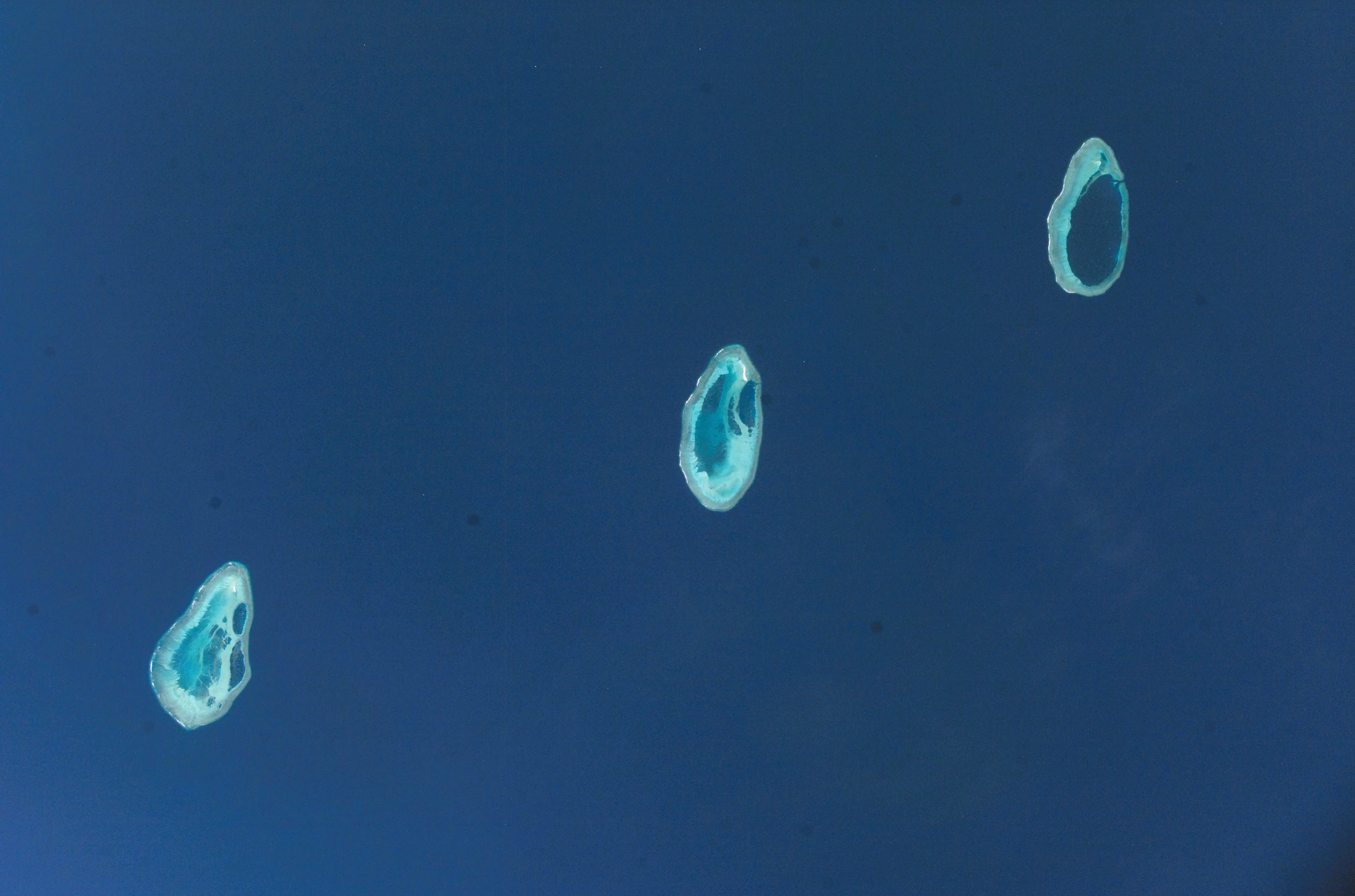
Satellite aerial view of three oval shaped coral atolls situated in the deep blue waters of the Indian Ocean.
A satellite view showing the three distinct atolls of the Rowley Shoals.

Rowley Shoals history and protected-area timeline

Rowley Shoals takes its name from Captain Phillip Parker King, who charted the reefs during his 1818 survey of the Australian coast and honored Captain Rowley, the first person recorded to have sighted the Imperieuse Reef in 1800. Mermaid Reef and Clerke Reef were also named by King, after his ship HMS Mermaid and after Captain Clerke, who had previously reported sightings of the reef from a whaler between 1800 and 1809.

Long before European charting, the reefs were known to Indonesian fishermen. From at least the mid-18th century, fishers from several islands in the Indonesian archipelago visited the Rowley Shoals in seasonal voyages that targeted trepang (sea cucumbers), turtle shell, trochus shell, and shark fin. Earlier visitors are believed to have called the reefs Pulau Pulo Dhaoh, while fishers from Roti Island, south of Timor, knew them as Pulau Bawa Angin. Individual reefs also carried distinctive local names: Mermaid Reef as Pulau Manjariti, Clerke Reef as Pulau Tengah, and Imperieuse Reef as Pulau Matsohor.

In modern times, Rowley Shoals first drew outside attention as a destination for charter boats based in Broome around 1977, when operators began running diving and deep-sea fishing expeditions to the reefs. This marked the beginning of the area's reputation as a remote offshore marine experience. Formal conservation recognition followed, with the Rowley Shoals Marine Park declared in 1990 and later expanded in 2004, and with Mermaid Reef subsequently added to the Commonwealth marine park system.

Rowley Shoals landscape and geographic character

The defining landscape character of Rowley Shoals is its vertical relief: each reef climbs abruptly from a deep oceanic floor, producing steep underwater walls and dramatic drop-offs. The reefs sit at the far outer edge of one of the broadest continental shelves in the world, which means that despite the relatively shallow reef tops and lagoons, the surrounding seafloor plunges to depths of roughly 230 m at Imperieuse Reef, 390 m at Clerke Reef, and 440 m at Mermaid Reef.

Above water, the landscape is austere and minimal. Imperieuse Reef features numerous exposed coral boulders rising about 3 m above the water line along its southeastern edge, together with large reef flats that fall dry at low tide. Clerke Reef likewise has drying boulders on its eastern and western sides, and supports Bedwell Islet, a bare sand cay roughly 2 m high near its northern end. Mermaid Reef is the most enclosed of the three, with a continuous coral rim that dries at low water and only a single narrow passage roughly 60 m wide on its northeast side. The only other significant land feature is Cunningham Islet on Imperieuse Reef, a small unvegetated sand cay standing about 3.7 m high and surrounded by its own tiny lagoon, where the Imperieuse Reef Light stands.

The submerged landscape is equally distinctive: Imperieuse Reef contains two separate lagoons, while Clerke Reef has a single lagoon dotted with detached coral patches. The result is a series of nested, ring-shaped reef structures that appear small at the surface but expand dramatically beneath the waves.

Rowley Shoals ecosystems, habitats, and plant life

Rowley Shoals represents an unusual convergence of oceanic and reef ecology, sitting where very deep offshore waters meet a series of shallow, isolated coral platforms. The isolation and offshore setting contribute to water clarity and to ecological conditions that differ from the more turbid, nearshore reefs along the Western Australian coast.

The reefs support a complex community of hard corals, reef-associated invertebrates, and pelagic species that move through the clear water column above and around the reef structures. Coral boulders emerging from the reef flats at low tide, along with patches of sand and rubble within the lagoons, provide habitat for a wide range of reef organisms. Because the reef tops are intermittently exposed and the cays are barren, terrestrial habitats are essentially absent, and the ecological identity of Rowley Shoals is overwhelmingly marine.

Ecologically, the shoals are also notable as the only known natural habitat for several unusual species, including the Western Australian sculpin, which underscores the area's value for marine biodiversity. The broader reef system is part of an interconnected marine park network that links Rowley Shoals, Mermaid Reef, and the Argo-Rowley Terrace, supporting ecological processes across a large offshore area.

Rowley Shoals wildlife and species highlights

Wildlife at Rowley Shoals is dominated by marine fauna, given the near-total absence of terrestrial habitat. The reefs host diverse coral communities and the larger fish, invertebrate, and pelagic species typical of clear, offshore tropical waters in the Indian Ocean. Divers and fishers visiting the area commonly encounter reef sharks and other predatory species that patrol the reef edges, alongside schooling pelagic fish attracted to the steep drop-offs.

The most distinctive wildlife feature of Rowley Shoals is its role as the only known origin and home of several species not found elsewhere, including the Western Australian sculpin. This endemism gives the reefs a particular scientific significance, as they preserve ecological communities that do not appear to have equivalents on nearby reef systems. In addition, the same reef environments historically supported turtle populations, sea cucumber populations, and shark populations targeted by traditional Indonesian fishermen, and these groups remain part of the broader marine fauna of the area.

Because the islands themselves are bare sand cays lacking vegetation, they offer almost no habitat for birds beyond occasional visitors or seabirds using them as temporary resting points. The genuine wildlife richness of Rowley Shoals lies below the waterline, where the isolation and clarity of the reefs create a setting that continues to draw scientific and recreational interest.

Rowley Shoals conservation status and protection priorities

Rowley Shoals is protected through a layered system of state and Commonwealth marine reserves, reflecting its high ecological value both as a coral reef system and as the sole known home for several species. All three reefs were registered on the former Register of the National Estate, and Mermaid Reef is listed on Australia's Commonwealth Heritage List in recognition of its natural significance.

The Rowley Shoals Marine Park covers Clerke Reef and Imperieuse Reef and is managed by the Western Australian Department of Environment and Conservation, originally declared in 1990 and extended in 2004. Mermaid Reef is protected separately as the Mermaid Reef Marine Park, an Australian marine park administered by Parks Australia. These two reserves are complemented by the Argo-Rowley Terrace Marine Park, a larger adjacent reserve that surrounds and overlaps them, extending protection across the wider submarine terrace on which the reefs sit.

Conservation interest in the area is driven by both ecological and geological values. The reefs are the only known habitat of several unusual species, including the Western Australian sculpin, and they preserve a rare example of an offshore, shelf-edge reef system in good condition. Their geological history, as remnants of a much larger Miocene barrier reef that once extended along the northwestern Australian coast, further reinforces their long-term scientific and conservation significance.

Rowley Shoals cultural meaning and human context

Rowley Shoals has a long pre-European history of use by Indonesian fishermen, who visited the reefs from at least the mid-18th century in search of trepang, turtle shell, trochus shell, and shark fin. Seasonal voyages from parts of the Indonesian archipelago brought fishermen to these distant reefs, and the local names they used for the reefs survive as a record of that earlier cultural connection.

These traditional visitors referred to the group as a whole as Pulau Pulo Dhaoh in earlier periods, while fishers from Roti Island, south of Timor, later called the reefs Pulau Bawa Angin. Individual reefs had their own names within this maritime tradition, including Pulau Manjariti for Mermaid Reef, Pulau Tengah for Clerke Reef, and Pulau Matsohor for Imperieuse Reef. This naming history reflects the Rowley Shoals as part of a broader regional maritime culture that linked communities across the Timor Sea with remote offshore reef systems.

In more recent decades, the cultural context has shifted toward recreational use, with charter operations from Broome shaping the area's identity as a destination for offshore diving and fishing trips. Despite this modern activity, the reefs remain uninhabited, with no permanent settlements, and their cultural footprint outside of traditional fishing is primarily tied to visitation-based marine recreation.

Top sights and standout views in Rowley Shoals

Rowley Shoals stands out for its combination of dramatic underwater topography, exceptional water clarity, and ecological isolation. The three reefs rise vertically from deep ocean floor, producing steep walls and abundant pelagic encounters that make the area a benchmark destination for divers and sport fishers traveling from Broome.

The system also carries strong scientific significance, both as the exclusive natural habitat of the Western Australian sculpin and as a rare surviving fragment of an ancient Miocene barrier reef. The layered marine park system, encompassing the Rowley Shoals Marine Park, Mermaid Reef Marine Park, and Argo-Rowley Terrace Marine Park, brings together state and Commonwealth protections that help preserve these qualities.

Best time to visit Rowley Shoals

Rowley Shoals experiences a tropical offshore climate typical of northwestern Australia, with generally warm water and conditions influenced by broader regional weather patterns. Charter expeditions from Broome typically take advantage of calmer offshore conditions during the cooler dry season months, when seas are often more settled and underwater visibility tends to remain favorable. During the wetter season, conditions on the open ocean can be more variable, with stronger winds and rougher seas potentially affecting access and the quality of diving experiences.

Because the reefs sit well offshore in deep oceanic water, conditions can change quickly even outside the wet season, and the character of a visit is shaped more by sea state and visibility than by any single calendar window. Wildlife viewing is relatively consistent year-round, with pelagic species, reef sharks, and other marine life present throughout the year, though divers often favor periods when winds are lightest to make the most of the long surface journey from the Kimberley coast.

Monthly climate preview

Track monthly average temperatures and precipitation patterns across the representative coordinate.

Rowley Shoals Climate Normals, Long-Term Temperature and Precipitation Rhythms

Historical climate records for Rowley Shoals reveal measured monthly temperature variations alongside shifting precipitation rates from NASA POWER data. Detailed month-by-month analysis provides deeper insight into long-term averages across the representative marine coordinate.
Annual mean27 °C
24 °C29 °C
Jan29°
Feb29°
Mar29°
Apr29°
May28°
Jun26°
Jul25°
Aug24°
Sep25°
Oct26°
Nov27°
Dec28°
Warmest month
April

29.2 °C

Coolest month
August

24.5 °C

Wettest month
February

5.1 mm/day

Driest month
September

0 mm/day

Park location guide

Geography guide, regional context, and park location map for Rowley Shoals

Rowley Shoals park geography, regions, and map view in Australia

Understand where Rowley Shoals sits in Australia through a broader geographic reading of the surrounding landscape, nearby location context, and its mapped position within the national park landscape.

How Rowley Shoals fits into Australia

Australia is a constitutional monarchy and federal parliamentary democracy comprising six states and ten territories. With a population of nearly 28 million, it is one of the world's most urbanised countries, with most people concentrated on the eastern seaboard. The country has a high Human Development Index and is known for its cultural diversity, ancient Aboriginal heritage, and unique wildlife.

Wider geography shaping Rowley Shoals in Australia

Australia occupies the entire Australian continent, the island of Tasmania, and numerous smaller islands. It is the world's flattest and driest inhabited continent, featuring vast deserts in the interior (the Outback), tropical rainforests along the eastern coast, and a coastline bordering the Indian and Pacific Oceans.

Map view of Rowley Shoals

Use this park location map to pinpoint Rowley Shoals in Australia, understand its exact geographic position, and read its mapped placement within the surrounding landscape more clearly.

Pigeon | © OpenStreetMap contributors

Location context for Rowley Shoals

Western Australia

Examine protected coral habitats, vertical reef walls, and isolated marine scenery.

Rowley Shoals Photos and Marine Landscapes: Visualizing Offshore Atolls

Visual documentation captures the steep underwater topography and remote marine habitats that define Rowley Shoals. Examining high-resolution photography reveals the structural character of these isolated Western Australian atolls.

Satellite aerial view of three oval shaped coral atolls situated in the deep blue waters of the Indian Ocean.

Park atlas

Compare surrounding reef formations and regional marine conservation zones

Explore Protected Areas and Other Marine Parks Near Rowley Shoals

Browse marine parks and protected areas sharing the continental shelf context of Rowley Shoals. Geographic comparison reveals broader oceanic ecosystems and connected regional marine reserves.
Marine protected areaWestern Australia
About 7.6 km away#1 closest

Northwest

Argo-Rowley Terrace Marine Park: Mapped Geography and Marine Protected Area Context

Expansive oceanic territory within the Western Australian region

Argo-Rowley Terrace Marine Park represents a vast offshore environment protecting diverse aquatic life and unique seafloor features. This marine protected area bridges the gap between the isolated Rowley Shoals and deep-water abyssal hills. The region is essential for understanding the structural geology of the ocean floor, encompassing everything from shallow reefs to abyssal plains in the remote north-west of Australia.

Area
146,003 km²
Established
2018
IUCN
VI
Relief
Lowland
Marine protected areaWestern Australia
About 181 km away#2 closest

Northeast

Kimberley Marine Park: Atlas of Protected Marine Habitats and Submerged Coastal Geography

Western Australia Marine Protected Area and seafloor terrain

Spanning over 74,000 square kilometres of the Indian Ocean, Kimberley Marine Park encompasses an intricate underwater landscape. From shallow banks and pinnacles to deep oceanic trenches, the park serves as a vital refuge for migratory humpback whales, sea turtles, and dugongs within a complex Commonwealth marine reserve network.

Area
74,469 km²
Established
2018
IUCN
VI
Relief
Lowland
Marine protected areaWestern Australia
About 380 km away#3 closest

Southwest

Dampier Marine Park: Geographic Overview and Marine Protected Area Mapping

Protected shelf ecosystems of the Pilbara coast, Western Australia

Dampier Marine Park spans a mosaic of shallow shelf waters near the Dampier Archipelago. This protected area integrates diverse management zones to support migratory pathways for marine megafauna and preserve benthic habitats across the Northwest Shelf Province. Understanding its boundaries provides insight into the intersection of conservation and marine spatial planning in one of Australia's most significant coastal bioregions.

Area
1,252 km²
Established
2018
IUCN
VI
Relief
Lowland
National parkPilbara
About 438 km away#4 closest

Southwest

Murujuga National Park: Pilbara Region's Protected Natural Landscape

Explore mapped park boundaries and regional geography.

Murujuga National Park represents a vital protected territory within the Pilbara region of Australia. This page provides focused atlas information on the park's geographic scope, mapped terrain, and its significance as a national park. Understand the unique landscape context of Murujuga National Park and its place within the broader regional geography, offering detailed insights for geographic exploration.

Area
48.51 km²
Established
2013
Climate
Arid
Access
Moderate access
National parkWestern Australia
About 475 km away#5 closest

Southwest

Millstream Chichester National Park: A Mapped Protected Landscape in Western Australia

Explore its geographic spread and natural terrain features.

Millstream Chichester National Park is a designated national park within the vast geographic expanse of Western Australia. This entry provides detailed atlas-level information focused on its protected boundaries and distinct landscape characteristics. Understand the park's role within the regional geography and its significance as a mapped natural area for discovery and exploration.

Area
2,381.67 km²
Established
1970
IUCN
II
Relief
Mixed relief
Marine protected areaWestern Australia
About 514 km away#6 closest

Southwest

Montebello Islands Marine Park: Western Australia Marine Protected Area Atlas

Mapping tropical reefs and archipelago terrain

Montebello Islands Marine Park preserves a significant archipelago and its surrounding tropical marine environment off the Pilbara coast. The area features extensive reef flats, mangrove communities, and deep oceanic waters that provide essential habitat for marine life and nesting sea turtles. Its physical profile includes a unique mix of natural reef-building processes and human history, making it a key component of the Western Australian marine conservation landscape.

Area
583.44 km²
Established
2004
IUCN
II
Relief
Lowland
National parkWestern Australia
About 554 km away#7 closest

South

Karijini National Park: Explore the Protected Landscape and Geographic Context in Western Australia

Mapped natural terrain and regional geography for this Australian national park.

Karijini National Park is a designated national park in Western Australia, offering a distinct protected landscape for geographic exploration. This detailed entry provides context on its specific location within the state, its mapped boundaries, and the surrounding natural terrain. It serves as a foundational element for understanding the park's role within the larger atlas of protected areas and natural geography across Australia.

Area
6,274.22 km²
Established
1969
IUCN
II
Visitors
166K annual
National parkWestern Australia
About 595 km away#8 closest

East

Windjana Gorge National Park: Ancient Devonian Reef Gorge Landscape Exploration

Explore mapped geography and fossil-rich sandstone formations.

Windjana Gorge National Park offers an unparalleled opportunity to explore a protected landscape defined by its ancient Devonian reef origins. Situated in Western Australia, this national park protects a dramatic gorge carved through fossil-rich sandstone, revealing a 375-million-year-old geological past. Examine the mapped park boundaries and the unique contours of this ancient reef system, providing crucial context for understanding the natural history and landscape evolution of the Kimberley region.

Area
20.5 km²
Established
1971
IUCN
II
Relief
Lowland

Common questions about visiting, size, designation, and location context for Rowley Shoals

Rowley Shoals FAQs for park facts, access, geography, and protected area context

Find quick answers about Rowley Shoals, including protected-area facts, park geography, trail and visitor context, and how the park fits into its surrounding country and regional landscape.
MoriAtlas Explorer

Continue Your Protected Areas Search Across the Global Atlas

Deepen your exploration by continuing the structured search for national parks and protected areas worldwide. Utilize the comprehensive filtering capabilities to compare different conservation landscapes and refine your understanding of global park geography. Discover more about the distribution and characteristics of protected natural areas.

Global natural geography