

Mori Atlas logo
National parkSaanane Island National Park

Discover mapped park boundaries and regional geographic context for this national park.

Saanane Island National Park: Tanzania's Protected Landscape in Mwanza Region

Saanane Island National Park serves as a distinct protected area within the geographic landscape of Tanzania's Mwanza Region. This national park entry provides detailed atlas-style information focused on its mapped boundaries and regional setting, offering a clear view of its protected landscape identity for focused geographic discovery.

National ParkIslandLake VictoriaPrimatesDe-brazza's MonkeyTanzania

Saanane Island National Park

National park

Park overview

Structured park overview, official facts, and landscape profile for Saanane Island National Park

Saanane Island National Park park facts, protected area profile, and essential visitor context
Review the core facts for Saanane Island National Park, including designation, size, terrain, visitor scale, habitats, and operating context in one park-focused overview.

About Saanane Island National Park

Saanane Island National Park represents a distinctive addition to Tanzania's protected area network as the country's smallest national park and one of its few island-based protected sites. The park occupies a freshwater island in the southeastern portion of Lake Victoria, Africa's largest lake, within the Mwanza Region of northern Tanzania. The island's isolated position in Lake Victoria has shaped its ecological character, creating a unique island ecosystem that supports species assemblages distinct from the mainland savanna landscapes that dominate much of Tanzania's protected areas. The park was established in 2013, elevating its status from a game sanctuary to a fully designated national park under the management of the Tanzanian National Parks Authority. This transition reflected the growing recognition of the island's conservation value, particularly for its primate populations and the unique ecological island setting. The park's proximity to Mwanza City, Tanzania's second-largest city, makes it accessible for day visitors seeking a compact wildlife experience contrasting with Tanzania's extensive savanna parks.

Quick facts and research context for Saanane Island National Park

Saanane Island National Park occupies 2.8 square kilometers in Lake Victoria, making it Tanzania's smallest national park by area. The park was formally established in 2013, though it existed earlier as a game sanctuary. It lies within Ilemela District of Mwanza Region, with Mwanza City serving as the nearest urban center. The park operates under the management of the Tanzanian National Parks Authority and recorded approximately 5,278 visitors in 2012. The island is named after Mzee Saanane Chavandi, a local farmer and fisherman who once lived on the island.

Park context

Deeper park guide and search-rich context for Saanane Island National Park

Saanane Island National Park history, landscape, wildlife, and travel context
Explore Saanane Island National Park through its history, landscape character, ecosystems, wildlife, conservation priorities, cultural context, and seasonal travel timing in a structured park guide built for atlas discovery and search intent.

Why Saanane Island National Park stands out

Saanane Island National Park is most notably recognized for housing Tanzania's sole population of De-brazza's monkeys, a species with a limited distribution across central African riparian forests. The park's island setting within Lake Victoria also makes it unique among Tanzania's protected areas, offering a distinct freshwater island ecosystem surrounded by the vast waters of Africa's largest lake. The dramatic history of the sanctuary being accidentally bombed during the 1979 Uganda-Tanzania War adds a remarkable historical dimension to the park's identity.

Saanane Island National Park history and protected-area timeline

The island that now comprises Saanane Island National Park has a remarkable historical chapter rooted in regional conflict. During the Uganda-Tanzania War of 1978 to 1979, the sanctuary then known as the Saa Nane Island Game Sanctuary experienced an unusual wartime incident. On March 29, 1979, Libyan leader Muammar Gaddafi ordered a Tupolev Tu-22 bomber to attack Mwanza, intending to intimidate the Tanzanian government into halting its invasion of Uganda. The bomber missed its intended urban target entirely, and its five anti-personnel rockets struck the game sanctuary instead. The attack resulted in the death of several antelope and numerous birds, with one worker receiving minor injuries. This accidental wartime bombing represents a singular event in the history of Tanzania's protected areas, underscoring how regional conflicts can unexpectedly affect conservation infrastructure.

Saanane Island National Park landscape and geographic character

Saanane Island rises from the waters of Lake Victoria as a landform characterized by rolling terrain and vegetation cover suited to the lake's humid riparian environment. The island's landscape differs markedly from the surrounding lake waters and the mainland savanna environments found throughout the Mwanza Region. The island supports a mix of woodland and forest vegetation that provides habitat for its primate populations and other wildlife. The surrounding lake waters, which comprise part of the park's protected zone, add a significant aquatic dimension to the landscape. The park's small size means visitors can traverse much of the island's terrain within a single excursion, experiencing the island's varied habitats in a compact area.

Saanane Island National Park ecosystems, habitats, and plant life

The ecological character of Saanane Island centers on its island forest and woodland habitats that contrast with the broader savanna ecosystems of mainland Tanzania. The island's vegetation supports several primate species, most notably the De-brazza's monkey, which finds its only known habitat in Tanzania within this island sanctuary. This species typically inhabits riparian forests and swampy areas across central Africa, and the island provides appropriate habitat within the Lake Victoria basin. The woodland and forest habitats also support populations of vervet monkeys, which are more widely distributed across Tanzania, as well as rock hyraxes occupying the island's rocky areas. The surrounding lake waters and shoreline areas provide additional aquatic and riparian habitat that contributes to overall biodiversity.

Saanane Island National Park wildlife and species highlights

Saanane Island National Park supports a diverse mammalian fauna adapted to the island's forest and woodland habitats. The park's flagship species is the De-brazza's monkey, found nowhere else in Tanzania and representing a significant conservation priority. The island also hosts populations of vervet monkeys, wild cats, zebras, and rock hyraxes. These mammal species occupy different ecological niches across the island, from the tree canopy used by primates to the rocky outcrops favored by hyraxes. The avian community is equally notable, with more than 40 bird species recorded on the island. This bird diversity reflects the varied habitats present on the island and its position within Lake Victoria, a region of significant importance for African birdlife.

Saanane Island National Park conservation status and protection priorities

The designation of Saanane Island as a national park reflects its conservation significance, particularly for protecting Tanzania's only population of De-brazza's monkeys. This primate species, while not globally threatened, has a relatively restricted range in Africa, making the island population critically important for the species' conservation within Tanzania. The island's isolation within Lake Victoria provides a natural boundary that helps protect wildlife populations from human encroachment and habitat fragmentation pressures that affect mainland protected areas. The park's small size and the surrounding lake waters create a contained ecosystem where conservation management can be effectively implemented. The elevation from game sanctuary to national park status in 2013 demonstrates Tanzania's commitment to protecting this unique island habitat.

Saanane Island National Park cultural meaning and human context

Saanane Island carries cultural significance through its namesake, Mzee Saanane Chavandi, a local farmer and fisherman who historically lived on the island. The park's location within the Mwanza Region places it in a region inhabited by various Bantu-speaking communities with deep connections to Lake Victoria. The lake itself holds substantial cultural and economic importance for local communities, supporting fishing livelihoods and serving as a resource around which regional identities have developed. While the park itself is a relatively new protected area, the island's association with local communities predates its conservation designation.

Top sights and standout views in Saanane Island National Park

Saanane Island National Park offers visitors the unique opportunity to observe De-brazza's monkeys in Tanzania's only known population of this species. The island setting provides a distinct contrast to Tanzania's famous savanna parks, offering a compact wilderness experience where visitors can explore diverse habitats within a small area. The park's history as a sanctuary bombed during the 1979 Uganda-Tanzania War adds historical intrigue to a visit. The proximity to Mwanza City allows for accessible day trips, while the island's small scale enables thorough exploration within a few hours. The combination of primate-focused wildlife viewing, island atmosphere, and historical significance creates a distinctive Tanzania park experience.

Best time to visit Saanane Island National Park

The best time to visit Saanane Island National Park generally corresponds to the Dry season from June to October, when lower water levels and reduced vegetation density facilitate wildlife viewing across Tanzania's protected areas. The dry season typically offers more comfortable conditions for exploring the island on foot. The Wet seasons from November to May bring higher water levels around the island and denser vegetation, which can affect visibility but also bring different atmospheric qualities and potentially increased bird activity. Year-round visitation is possible given the park's small scale and accessible location near Mwanza City, but visitors seeking optimal wildlife viewing conditions should consider planning during the dry season months.

Park location guide

Geography guide, regional context, and park location map for Saanane Island National Park

Saanane Island National Park park geography, regions, and map view in Tanzania
Understand where Saanane Island National Park sits in Tanzania through a broader geographic reading of the surrounding landscape, nearby location context, and its mapped position within the national park landscape.

How Saanane Island National Park fits into Tanzania

Tanzania, officially the United Republic of Tanzania, is a presidential republic in East Africa within the African Great Lakes region. It was formed in 1964 through the unification of Tanganyika and Zanzibar. The country is known for its diverse wildlife, national parks including Serengeti and Ngorongoro, and significant archaeological sites with important hominid fossils.

Wider geography shaping Saanane Island National Park in Tanzania

Tanzania is located in East Africa within the African Great Lakes region. It is bordered by Uganda to the northwest, Kenya to the northeast, the Indian Ocean to the east, Mozambique and Malawi to the south, Zambia to the southwest, and Rwanda, Burundi, and the Democratic Republic of the Congo to the west. The country includes the mainland and the Zanzibar Archipelago.

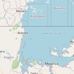
Map view of Saanane Island National Park

Use this park location map to pinpoint Saanane Island National Park in Tanzania, understand its exact geographic position, and read its mapped placement within the surrounding landscape more clearly.

Pigeon | © OpenStreetMap contributors

Location context for Saanane Island National Park

Ilemela DistrictMwanza Region
Park atlas

Trace the regional protected landscapes and park geography surrounding Saanane Island National Park in Tanzania.

Discover Related National Parks and Protected Areas Near Saanane Island in Lake Victoria
After exploring Saanane Island National Park, browse other national parks and protected areas across the Mwanza Region and wider Tanzanian geography. This extended view enables comprehensive atlas-style comparison, revealing diverse conservation landscapes and regional protected area patterns surrounding Lake Victoria.
National parkGeita Region

Rubondo Island National Park: Tanzanian National Park Geography and Mapped Boundaries

Explore the protected landscape within Geita Region.

Delve into the protected landscape of Rubondo Island National Park, a designated national park situated in Tanzania's Geita Region. This page provides essential geographic context, detailing the park's mapped boundaries and its contribution to the regional atlas. Understanding Rubondo Island National Park involves exploring its specific terrain and its significance as a protected natural area within the broader landscape.

Area
456.8 km²
Established
1965
IUCN
II
Visitors
1.5K annual
National parkMara Region

Serengeti National Park: National Park Atlas and Protected Landscape Discovery

Explore savanna grasslands, regional geography, and mapped park boundaries.

Serengeti National Park, a significant national park within Tanzania's Mara Region, offers an unparalleled view into a vast protected landscape. This page provides access to the park's geographic identity, its defining savanna ecosystem, and its role as a critical component of the regional atlas. Understand the mapped extent of its protected boundaries and the unique natural context that supports its renowned wildlife.

Area
14,763 km²
Established
1940
IUCN
II
Visitors
350K annual
Nature reserveTanzania

Kigosi National Park Nature Reserve: Mapped Boundaries and Geographic Identity in Tanzania

Explore the protected landscape and regional context of this Tanzanian reserve.

Kigosi National Park in Tanzania is a designated nature reserve, offering a key point for exploring protected landscapes and their geographic placement. This entry details the park's identity as a conservation area, focusing on its mapped boundaries and how it fits within the regional geography of Tanzania. For users interested in atlas exploration, this provides essential context on the park's natural terrain and its standing as a protected natural area.

Area
8,265 km²
Established
2024
IUCN
II
Relief
Lowland
National parkTanzania

Burigi-Chato National Park: Protected Landscape Atlas Entry for Tanzania

Explore the mapped geography and terrain of this Tanzanian national park.

Burigi-Chato National Park serves as a distinct protected area within Tanzania, detailed here for its geographic significance and atlas exploration value. Users can delve into the park's specific landscape characteristics, its protected boundaries, and its regional setting. This content is designed to support a deeper understanding of conservation lands and natural terrain within the East African context, offering a factual entry point for detailed geographic discovery.

Area
4,707 km²
Established
2019
IUCN
II
Relief
Mixed relief
National parkEastern Province

Akagera National Park National Park: Protected Landscape Geography and Atlas Exploration

Understand the mapped terrain and regional context of Akagera National Park.

Akagera National Park, designated as a national park, represents a vital protected landscape within Rwanda's Eastern Province. This atlas-focused entry provides essential geographic context, highlighting the park's mapped boundaries and natural terrain. Explore Akagera National Park as a key element in regional geography and a focal point for understanding protected land distribution.

Area
1,122 km²
Established
1934
Visitors
34K annual
Relief
Mixed relief
National parkNyanza Province

Ruma National Park: Kenya National Park within Nyanza Province Geographic Atlas

Explore its protected landscape and mapped geographic boundaries.

This MoriAtlas entry details Ruma National Park, a designated national park situated in Kenya's Nyanza Province. The focus is on its identity as a protected landscape, its specific geographic footprint, and its representation within a mapped atlas of natural areas. Users can investigate the park's terrain context, its regional placement, and the precise nature of its protected boundaries, offering structured geographic insight.

Area
120 km²
Established
1983
IUCN
II
Relief
Lowland
National parkKagera Region

Rumanyika-Karagwe National Park: Protected Landscape and Geographic Context in Kagera Region

Explore the mapped boundaries and regional setting of this national park.

Rumanyika-Karagwe National Park serves as a vital protected landscape within the Kagera Region of Tanzania. This entry facilitates a geographic discovery of the park, highlighting its mapped outlines and its role as a national park. Users can gain an understanding of its regional landscape context, providing a solid foundation for atlas-based exploration and appreciating the park's protected area status.

Area
247 km²
Established
2019
IUCN
II
Climate
Tropical
National parkBurundi

Ruvubu National Park: A National Park in Burundi Focused on Protected Landscape Geography

Explore the mapped boundaries and regional context of Ruvubu.

Investigate Ruvubu National Park, a protected natural area in Burundi, and understand its geographic significance. This page serves as a detailed atlas entry, highlighting the park's mapped extent and its contribution to the regional landscape of East Africa. Explore the protected-area context and geographical features that define Ruvubu National Park for discovery and analysis.

Area
508 km²
Established
1980
IUCN
II
Relief
Mixed relief

Common questions about visiting, size, designation, and location context for Saanane Island National Park

Saanane Island National Park FAQs for park facts, access, geography, and protected area context
Find quick answers about Saanane Island National Park, including protected-area facts, park geography, trail and visitor context, and how the park fits into its surrounding country and regional landscape.
MoriAtlas Explorer

Continue Your Protected Areas Search Across the Global Atlas

Deepen your exploration by continuing the structured search for national parks and protected areas worldwide. Utilize the comprehensive filtering capabilities to compare different conservation landscapes and refine your understanding of global park geography. Discover more about the distribution and characteristics of protected natural areas.

Global natural geography

