

Mori Atlas logo
National parkSaikai National Park

Discover the mapped boundaries and landscape context within Nagasaki Prefecture.

Saikai National Park: National Park Protected Area & Geographic Mapping

(Saikai Kokuritsu Kōen)

Saikai National Park stands as a significant protected natural area within Japan's Nagasaki Prefecture, offering a rich landscape for geographic exploration. This park provides a crucial element for understanding the regional geography of Kyushu, Japan, and its surrounding islands through detailed map data and atlas-style context. Users can investigate the specific protected boundaries and the natural terrain that defines this unique national park.

Marine National ParkArchipelagoRia CoastlineKyūshūNagasaki PrefectureIsland Landscape

Saikai National Park

National park

Park overview

Structured park overview, official facts, and landscape profile for Saikai National Park

Saikai National Park park facts, protected area profile, and essential visitor context
Review the core facts for Saikai National Park, including designation, size, terrain, visitor scale, habitats, and operating context in one park-focused overview.

About Saikai National Park

Saikai National Park represents one of Japan's most significant marine protection efforts, established to preserve the extraordinary archipelago landscape of western Nagasaki prefecture. The park stretches across a vast stretch of the East China Sea coast, encompassing the coastal regions of the Matsuura Peninsula that extends northward from Sasebo, one of Japan's prominent naval port cities. The protected area incorporates over 400 islands ranging from tiny islets to substantial landmasses like Hirado Island and the Gotō Islands chain. This marine-focused park differs from Japan's mountain-centric national parks, emphasizing instead the protection of coastal ecosystems, island landscapes, and the productive marine environments that support local fishing communities. The park's establishment in 1955 marked a turning point for the region, transforming what had been a restricted military zone during the pre-war period into a protected landscape open to the public. The Japanese government designated this area not only for its scenic beauty but also to preserve the ecological functions of these coastal waters and island habitats.

Quick facts and research context for Saikai National Park

Saikai National Park covers approximately 246 square kilometers of land alongside extensive marine waters in Nagasaki prefecture. It was established on March 16, 1955, and is managed by Japan's Ministry of the Environment. The park spans the Matsuura Peninsula coastline, the Kujūku Islands with over 200 islands, Hirado Peninsula, and the Gotō Islands archipelago. This is one of Japan's few predominantly marine national parks, characterized by its ria-style coastline and island-dotted waters. The nearest major cities are Sasebo, Hirado, and Fukue.

Park context

Deeper park guide and search-rich context for Saikai National Park

Saikai National Park history, landscape, wildlife, and travel context
Explore Saikai National Park through its history, landscape character, ecosystems, wildlife, conservation priorities, cultural context, and seasonal travel timing in a structured park guide built for atlas discovery and search intent.

Why Saikai National Park stands out

Saikai National Park is best known for its extraordinary archipelago landscape, where more than 400 islands of varying sizes create a complex coastal ecosystem. The Kujūku Islands near Sasebo form the park's most iconic section, with their tree-like cluster of islands visible from elevated viewpoints like Tenkai Peak. The Gotō Islands feature rare volcanic formations, dramatic columnar joint cliffs, and deep inlets. The park also preserves the historic cultural landscape of Hirado Island, once a major port for foreign trade and later a center of hidden Christianity. The combination of natural island scenery, marine environments, and cultural heritage makes this park distinctive among Japan's national parks.

Saikai National Park history and protected-area timeline

The establishment of Saikai National Park traces back to 1949, when then-Sasebo mayor Masasuke Nagata initiated efforts to protect and promote the region's natural beauty. Prior to World War II, the area had been part of the Sasebo Naval District of the Imperial Japanese Navy, functioning as a strategic military zone where photography was prohibited and civilian access was severely restricted. Following Japan's surrender and the dissolution of the military apparatus, Mayor Nagata recognized the potential for tourism to revitalize the local economy. He petitioned the Diet of Japan, supported by scientific studies conducted by researchers from Tokyo University, Kyoto University, and Nagasaki University. A promotional campaign organized by the Mainichi Shimbun newspaper helped build public support for the initiative. After years of effort, the park was officially established on March 16, 1955, becoming the 18th national park in Japan. The name Saikai references the historic Saikai Road, an old administrative division of Kyūshū, connecting the park to the region's deep historical roots.

Saikai National Park landscape and geographic character

The landscape of Saikai National Park is defined by its ria coastline, a drowned coast characterized by steep inlets and ridges that create a dramatic interface between land and sea. The park's central feature is its archipelago of over 400 islands, which create a complex pattern of sheltered bays, open sea channels, and interconnected waterways. Near Sasebo, the Kujūku Islands form a dense cluster of more than 200 islands that appear like floating green jewels rising from the blue waters. The Gotō Islands to the northwest feature more rugged terrain with interesting inlets, high cliffs, and rare volcanic formations that reflect the region's geological complexity. Hirado Island preserves historic coastal landscapes while offering varied topography including the impressive Shiodawara Cliff on the western coast of Hasami Island, which features dramatic columnar jointing. The landscape transitions from the more sheltered inner waters near the mainland to the more exposed outer islands facing the East China Sea, creating diverse coastal environments within a single protected area.

Saikai National Park ecosystems, habitats, and plant life

The natural environment of Saikai National Park reflects its position in the warm temperate zone of southern Japan, influenced significantly by the Kuroshio current that flows past the islands. This marine setting supports semi-tropical vegetation patterns, including the presence of tree ferns that thrive in the mild, humid climate. The warm ocean currents that pass through the park's waters create productive fishing grounds that have supported coastal communities for centuries. The park's ecological significance extends beyond the terrestrial vegetation to encompass the marine ecosystems within its boundaries. The complex archipelago pattern creates diverse habitat types, from sheltered tidal zones to more exposed open-sea environments. The combination of the mild climate, ocean currents, and varied island terrain produces an environment that supports both typical Japanese coastal species and some more subtropical species at the northern edge of their range.

Saikai National Park wildlife and species highlights

The wildlife of Saikai National Park is most notable for its marine dimension, as the protected waters support diverse fish populations and other marine organisms that form the basis of local fishing industries. The park's location along migratory routes and the influence of warm currents bring variety to the marine life encountered in its waters. The islands provide nesting and resting sites for seabirds, while the surrounding seas contain numerous fish species that contribute to the ecological character of the park. While specific species documentation in the sources is limited, the overall ecological setting suggests birdlife and marine species typical of Japan's western coastal waters. The productive fishing grounds referenced in the sources indicate abundant marine life, though the park is more noted for its scenic archipelago landscapes than for any singular flagship species.

Saikai National Park conservation status and protection priorities

Saikai National Park serves important conservation functions as one of Japan's primary marine-focused protected areas. The park protects both terrestrial island environments and significant marine waters, supporting biodiversity in a region where coastal development and fishing pressure could otherwise degrade natural values. The designation of special protection areas within the park framework helps preserve the most sensitive habitats while allowing sustainable use of other areas. The park's establishment represented an important step in protecting Japan's coastal and island ecosystems, which had historically received less protection than mountain and forest environments. The continued management by the Ministry of the Environment focuses on balancing conservation with appropriate public access and sustainable use by local communities who depend on the marine resources of these waters.

Saikai National Park cultural meaning and human context

Saikai National Park encompasses landscapes shaped by centuries of human activity, particularly evident on Hirado Island, which served historically as a major port for foreign trade during the period of limited Japanese contact with the outside world. The island later became significant as a center of hidden Christianity, when practitioners concealed their faith during periods of persecution. This cultural dimension adds historical depth to the park's natural values, creating a landscape where natural beauty and human history intertwine. The Gotō Islands similarly contain cultural heritage related to the Christian tradition. The park's Japanese slogan, describing it as a crossroads of islands, sea, nature, and culture, reflects this integration of natural and cultural elements. The surrounding communities maintain traditional connections to the sea that have shaped both their livelihoods and their relationship with the archipelago environment.

Top sights and standout views in Saikai National Park

The park offers several standout experiences: viewing the Kujūku Islands cluster from Tenkai Peak or Mount Yubari near Sasebo, where dozens of islands appear as a natural sculpture against the sea; exploring the dramatic coastal cliffs like Shiodawara Cliff with its columnar jointing; visiting the historic sites of Hirado Island related to trade and hidden Christianity; discovering the volcanic features of the Gotō Islands including pot holes on Ojika Island and unique geological formations; and experiencing the traditional island communities scattered throughout the archipelago. The Osezaki Lighthouse on the Gotō Islands provides one of the westernmost coastal views in Japan. The park's diverse island landscapes, ranging from tiny islets to populated islands with fishing communities, offer varied experiences within a single protected area.

Best time to visit Saikai National Park

Saikai National Park can be enjoyed year-round due to its mild climate, though spring and autumn offer the most comfortable conditions for outdoor exploration. The summer months bring warm temperatures suitable for marine activities but also coincide with peak visitor season. Winter temperatures remain moderate compared to northern Japan, though some island services may be reduced during the off-season. The park's coastal and marine focus makes any season viable for appreciating its landscapes, though the dramatic seasonal changes in light and atmosphere can dramatically alter the appearance of the island scenery. The clarity of the winter season often provides excellent visibility for viewing the archipelago from elevated points, while the lush green of summer emphasizes the semi-tropical character of the vegetation.

Park location guide

Geography guide, regional context, and park location map for Saikai National Park

Saikai National Park park geography, regions, and map view in Japan
Understand where Saikai National Park sits in Japan through a broader geographic reading of the surrounding landscape, nearby location context, and its mapped position within the national park landscape.

How Saikai National Park fits into Japan

Japan is an island nation in East Asia comprising over 14,000 islands in the Pacific Ocean. The country operates as a unitary parliamentary constitutional monarchy with Emperor Naruhito as the reigning monarch and Prime Minister Sanae Takaichi leading the government. With a population of approximately 123 million, Japan is the world's 11th most populous country and a major economic power with one of the strongest militaries, though it has constitutionally renounced its right to declare war.

Wider geography shaping Saikai National Park in Japan

Japan is an island nation in the Pacific Ocean, bordered to the west by the Sea of Japan and extending from the Sea of Okhotsk in the north to the East China Sea in the south. The Japanese archipelago lies off the northeast coast of the Asian mainland. Approximately 75% of Japan's terrain is mountainous and heavily forested, with agricultural land and urbanized populations concentrated along the eastern coastal plains. The country is divided into 47 administrative prefectures and eight traditional regions.

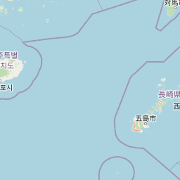
Map view of Saikai National Park

Use this park location map to pinpoint Saikai National Park in Japan, understand its exact geographic position, and read its mapped placement within the surrounding landscape more clearly.

Pigeon | © OpenStreetMap contributors

Location context for Saikai National Park

Nagasaki Prefecture
Park atlas

Compare the unique island landscapes and coastal protected areas across western Kyūshū, tracing regional geography beyond Saikai National Park.

Discover More National Parks and Protected Areas Near Saikai National Park in Kyūshū, Japan
After immersing yourself in Saikai National Park's unique marine archipelago, browse other nearby national parks and protected areas within the Kyūshū region of Japan. Expand your atlas-based discovery by comparing diverse coastal geographies, island ecosystems, and distinct conservation landscapes in their regional context.
National parkNagasaki Prefecture

Unzen-Amakusa National Park: Volcanic Terrain and Island Geography

Explore Nagasaki Prefecture's Protected Landscape

Unzen-Amakusa National Park represents a significant protected area within Japan's geography, characterized by the imposing presence of Mount Unzen and the distinct maritime environment of the Amakusa islands. This national park offers an opportunity to study volcanic landscapes, coastal formations, and the rich cultural history intertwined with its natural setting. Understanding its mapped boundaries and geographic context provides valuable insight into Japan's protected lands and regional landscape diversity.

Area
282.79 km²
Established
1934
IUCN
II
Relief
Mixed relief
National parkJeju Province

Hallasan National Park: South Korea's Highest Mountain National Park on Jeju

Volcanic Terrain and Mapped Protected Boundaries

Hallasan National Park encompasses South Korea's highest mountain, a massive shield volcano on Jeju Island. This page details the park's protected landscape, from sub-tropical forests to alpine environments, and its prominent role within Jeju Province's geography. Discover its mapped terrain and unique geological features, including the summit crater lake Baekrokdam.

Area
153.11 km²
Established
1970
IUCN
II
Relief
Mountain
National parkJapan

Kirishima-Kinkowan National Park: Exploring Japan's National Park Geography and Mapped Boundaries

A protected landscape within Japan's diverse terrain.

Kirishima-Kinkowan National Park represents a distinct protected area within Japan, offering critical insights for geographic exploration. This page details the park's specific mapped boundaries and its contribution to the regional landscape. Understanding this national park provides a structured entry point for exploring Japan's protected natural areas and their unique geographical characteristics through an atlas lens.

Area
365.86 km²
Established
1934
IUCN
II
Relief
Mountain
National parkŌita Prefecture

Aso-Kujū National Park: Ōita Prefecture's Protected Landscape Atlas

Mapped boundaries and regional geographic context for this national park.

Delve into the protected landscape of Aso-Kujū National Park, situated within the geographic region of Ōita Prefecture. This page provides detailed insight into the park's mapped terrain, its designation as a national park, and its contribution to the atlas of protected areas. Understand the park's landscape context and its significance as a conserved natural area.

Area
726.78 km²
Established
1934
IUCN
II
Relief
Mountain
National parkSouth Korea

Hallyeohaesang National Park: South Korea National Park Geographic Atlas Entry

Explore mapped protected area boundaries and natural terrain.

As a designated national park in South Korea, Hallyeohaesang National Park offers a distinct geographic profile crucial for atlas exploration. This entry focuses on its protected landscape features, mapped territorial extent, and regional context within the Republic of Korea. Understand the park's specific geographical markers and its significance as a mapped protected area.

Area
545.63 km²
Established
1968
IUCN
II
Access
Access unknown
National parkSouth Korea

Dadohaehaesang National Park: Exploring South Korea's Coastal Protected Area Boundaries

Mapped landscape context and regional geography.

Delve into the protected landscape of Dadohaehaesang National Park, a significant national park located in South Korea. This entry provides critical geographic information, detailing the park's mapped boundaries and its place within the broader regional terrain. It serves as an essential resource for understanding the park's protected status and its unique natural features for those exploring national parks and protected areas within an atlas framework.

Area
2,321.5 km²
Established
1981
IUCN
II
Visitors
560K annual
National parkJeollanam-do

Wolchulsan National Park: Detailed Geographic and Protected Landscape Atlas Entry

Explore mapped boundaries and natural terrain context.

This MoriAtlas entry for Wolchulsan National Park provides a detailed look at its identity as a protected landscape within Jeollanam-do, South Korea. Focus is placed on its geographic context and mapped park boundaries, offering a foundation for understanding its place in the regional atlas. Discover the structured details of this national park's natural terrain and its significance as a preserved natural area.

Area
56.6 km²
Established
1988
IUCN
II
Relief
Mountain
National parkSouth Korea

Jirisan National Park: South Korea's Premier Protected Landscape and Map Resource

Explore the mapped terrain and protected area geography.

Jirisan National Park is a key protected area within South Korea, serving as a vital component of the nation's natural landscape. This atlas-focused content provides detailed geographic information, highlighting the park's mapped boundaries and its role within the regional context of the Korean Peninsula. Understand the distinct characteristics of this protected national park for comprehensive geographic discovery.

Area
471.75 km²
Established
1967
IUCN
II
Visitors
1.5M annual

Common questions about visiting, size, designation, and location context for Saikai National Park

Saikai National Park FAQs for park facts, access, geography, and protected area context
Find quick answers about Saikai National Park, including protected-area facts, park geography, trail and visitor context, and how the park fits into its surrounding country and regional landscape.
MoriAtlas Explorer

Continue Your Protected Areas Search Across the Global Atlas

Deepen your exploration by continuing the structured search for national parks and protected areas worldwide. Utilize the comprehensive filtering capabilities to compare different conservation landscapes and refine your understanding of global park geography. Discover more about the distribution and characteristics of protected natural areas.

Global natural geography