

Mori Atlas logo
National parkSan Lucas Island National Park

Discover the mapped boundaries and tropical dry forest of this Costa Rican island protected area.

San Lucas Island National Park: Protected Island Landscape and National Park Geography

San Lucas Island National Park represents a unique protected landscape situated in Costa Rica's Gulf of Nicoya. This national park preserves the island's distinct terrestrial ecosystems, characterized by tropical dry forest and coastal terrain, alongside its surrounding marine waters. As an integral part of Costa Rica's extensive network of protected areas, San Lucas Island offers a specific focus on island ecology and conservation within the broader context of regional geography and national park exploration.

island parkPacific coasttropical dry forestmarine protected areaCosta Rica national parksGulf of Nicoya

San Lucas Island National Park

National park

Park overview

Structured park overview, official facts, and landscape profile for San Lucas Island National Park

San Lucas Island National Park park facts, protected area profile, and essential visitor context

Review the core facts for San Lucas Island National Park, including designation, size, terrain, visitor scale, habitats, and operating context in one park-focused overview.

About San Lucas Island National Park

San Lucas Island National Park is located on San Lucas Island, an island in the Gulf of Nicoya along Costa Rica's Pacific coast. The park was established to protect the island's natural ecosystems, which include tropical dry forest, coastal scrub vegetation, and the surrounding marine environment. The island itself is characterized by its rugged terrain and coastal cliffs, with vegetation adapted to the seasonal dry conditions typical of the Guanacaste region. The park's marine component protects waters surrounding the island, contributing to the conservation of coastal and reef ecosystems in the Gulf of Nicoya.

Quick facts and research context for San Lucas Island National Park

San Lucas Island National Park is situated in the Gulf of Nicoya in Puntarenas Province, Costa Rica. The park protects the island's tropical forest, coastal scrub, and surrounding marine environments. Costa Rica maintains one of the world's most extensive national park systems, and this island reserve contributes to the country's conservation network in the Pacific coastal region. The island's history includes use as a lazaretto or leper colony during the 19th and 20th centuries.

Protection and recognition

Documenting official designation frameworks and recorded management classifications.

San Lucas Island National Park Protection Status and Official Designation Framework

A closer look at San Lucas Island National Park reveals its specific protection framework and how its mixed management scope structures local conservation efforts. Reviewing official data records helps researchers track conservation status and understand how the island territory fits into regional environmental networks.

Protection details

Protection scope
Mixed
Transboundary protection
No
Park context

Deeper park guide and search-rich context for San Lucas Island National Park

San Lucas Island National Park history, landscape, wildlife, and travel context

Explore San Lucas Island National Park through its history, landscape character, ecosystems, wildlife, conservation priorities, cultural context, and seasonal travel timing in a structured park guide built for atlas discovery and search intent.

Why San Lucas Island National Park stands out

San Lucas Island National Park is known for its isolated island ecosystem in the Gulf of Nicoya, where tropical dry forest meets coastal marine environments. The park provides habitat for various bird species and terrestrial wildlife typical of Pacific island environments in Costa Rica. Its combination of historical significance as a former leper colony and its role in protecting island biodiversity makes it distinctive among Costa Rica's protected areas.

San Lucas Island National Park history and protected-area timeline

San Lucas Island has a notable human history that preceded its designation as a national park. The island served as a lazaretto, or leper colony, from the late 19th century through much of the 20th century. This historical use meant the island was largely isolated from regular human settlement, which inadvertently contributed to the preservation of its natural environments. The former institutional presence on the island left some infrastructure, though the primary focus of the national park is on conservation of the island's natural landscapes and ecosystems.

San Lucas Island National Park landscape and geographic character

San Lucas Island features a landscape of tropical island terrain with coastal cliffs, rocky shores, and interior forested areas. The island rises from the waters of the Gulf of Nicoya, with vegetation dominated by tropical dry forest and scrubland typical of the Pacific coastal region of Costa Rica. The surrounding marine environment includes coastal waters and reef areas that contribute to the park's ecological diversity.

San Lucas Island National Park ecosystems, habitats, and plant life

The park protects island ecosystems including tropical dry forest, secondary forest growth, and coastal vegetation communities. The isolation of the island has allowed for the development of distinctive ecological patterns, with species adapted to the island environment. The marine portion of the park protects coastal waters important for fish populations and marine biodiversity in the Gulf of Nicoya.

San Lucas Island National Park wildlife and species highlights

The island supports birdlife typical of Pacific island environments in Costa Rica, including various resident bird species. The combination of forest habitats and coastal areas provides foraging and nesting opportunities for avian species. Marine waters around the island support fish and other sea life relevant to the Gulf of Nicoya ecosystem.

San Lucas Island National Park conservation status and protection priorities

San Lucas Island National Park contributes to Costa Rica's national park system and conservation network. The protected area maintains both terrestrial and marine ecosystems important for regional biodiversity. The park's establishment reflects Costa Rica's commitment to comprehensive environmental protection that includes island environments and coastal marine areas.

San Lucas Island National Park cultural meaning and human context

The island's historical role as a leper colony from the late 1800s through the mid-20th century gives the site a distinctive human history. This period of isolation shaped both the island's development and contributed to the preservation of its natural environments due to limited human impact in most areas. The historical institutional presence contrasts with the island's current nature-focused identity as a national park.

Top sights and standout views in San Lucas Island National Park

San Lucas Island National Park offers a distinctive combination of island wilderness, tropical dry forest, and marine protection in the Gulf of Nicoya. The park provides an island exploration experience within Costa Rica's renowned protected areas network. The historical dimension of the former leper colony adds cultural context to the natural landscape.

Best time to visit San Lucas Island National Park

The best time to visit San Lucas Island National Park corresponds to the dry season in Costa Rica's Pacific lowlands, typically from December through April. During this period, visitor access to the island is generally more consistent and weather conditions are more favorable for outdoor exploration. The green season from May to November brings more rain but also lush vegetation. Visitors should check current access information as island visitation may involve boat transportation from the mainland.
Monthly climate preview

Measured annual temperature averages and precipitation rhythms for San Lucas Island National Park

San Lucas Island National Park Climate and Long Term Monthly Weather Patterns

San Lucas Island National Park exhibits distinct long term temperature and precipitation patterns across representative coordinate samples recorded from 1991 to 2020. Reviewing the complete twelve month climate profile reveals full monthly variations in average minimum and maximum temperatures alongside daily precipitation normals.
Annual mean27 °C
26 °C29 °C
Jan27°
Feb28°
Mar29°
Apr29°
May28°
Jun27°
Jul27°
Aug27°
Sep26°
Oct26°
Nov26°
Dec26°
Warmest month
April

29.1 °C

Coolest month
October

25.8 °C

Wettest month
October

7.6 mm/day

Driest month
March

0.2 mm/day

Park location guide

Geography guide, regional context, and park location map for San Lucas Island National Park

San Lucas Island National Park park geography, regions, and map view in Costa Rica

Understand where San Lucas Island National Park sits in Costa Rica through a broader geographic reading of the surrounding landscape, nearby location context, and its mapped position within the national park landscape.

How San Lucas Island National Park fits into Costa Rica

Costa Rica is a Central American country with coastlines on both the Caribbean Sea and Pacific Ocean. It gained independence from Spain in 1821 and operates as a unitary presidential republic with no standing military. The economy has diversified from agriculture into finance, pharmaceuticals, and ecotourism.

Wider geography shaping San Lucas Island National Park in Costa Rica

Costa Rica is located in Central America, bordered by Nicaragua to the north, the Caribbean Sea to the northeast, Panama to the southeast, and the Pacific Ocean to the southwest. It shares a maritime boundary with Ecuador. The terrain includes coastal plains, mountain ranges, and volcanic landscapes.

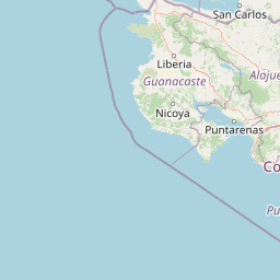
Map view of San Lucas Island National Park

Use this park location map to pinpoint San Lucas Island National Park in Costa Rica, understand its exact geographic position, and read its mapped placement within the surrounding landscape more clearly.

Pigeon | © OpenStreetMap contributors
Park atlas

Discover connected island ecosystems, coastal conservation landscapes, and regional park geography in Costa Rica's Pacific Gulf of Nicoya.

Explore Other National Parks and Protected Areas Near San Lucas Island National Park

Browse national parks and protected areas near San Lucas Island National Park, exploring diverse terrestrial and marine conservation landscapes within the Gulf of Nicoya. Compare the geography of adjacent island parks and coastal preserves to understand the broader network of protected areas across Costa Rica's Pacific region.
National parkCosta Rica
About 37 km away#1 closest

Southeast

Carara National Park: Protected Landscape Geography in Costa Rica

Explore the mapped terrain and park boundaries.

Carara National Park offers a focused exploration of protected landscape geography within Costa Rica. As a National Park, its mapped boundaries are integral to understanding its role in the country's natural atlas. This detail page provides specific geographic context and details relevant to atlas-based discovery, highlighting the park's unique position and protected-area identity for users interested in detailed mapping and regional natural context.

Area
52 km²
Established
1978
IUCN
II
Relief
Mixed relief
National parkCosta Rica
About 49 km away#2 closest

North

Arenal Volcano National Park: Costa Rica National Park Atlas and Mapped Terrain

Detailed geography and protected landscape context for a Costa Rican national park.

Gain a structured understanding of Arenal Volcano National Park, a protected natural area situated in Costa Rica. This page provides detailed geographic information, focusing on its mapped boundaries and landscape characteristics. It serves as a key resource for exploring the park's specific regional context and its role within the country's network of protected lands.

Area
121.24 km²
Established
1991
IUCN
II
Relief
Mountain
National parkCosta Rica
About 50 km away#3 closest

Northwest

Palo Verde National Park: Costa Rica's Protected Landscape Geography and Map Context

Explore mapped park boundaries and regional natural landscapes.

Delve into the geographic identity of Palo Verde National Park, a protected area within Costa Rica. This detail entry focuses on its mapped landscape, providing context for its protected boundaries and regional setting. Understand how Palo Verde National Park fits into the broader atlas of Costa Rican geography, offering a factual basis for exploring its specific natural terrain and its significance as a national park within Central America's rich biodiversity.

Area
184 km²
Established
1978
IUCN
II
Relief
Lowland
National parkCosta Rica
About 51 km away#4 closest

Northwest

Barra Honda National Park: Costa Rican Protected Landscape and Geographic Atlas

Mapped boundaries and regional park geography.

Barra Honda National Park stands as a notable protected area, offering a distinct geographic profile within Costa Rica. Its designation as a national park underscores its importance for landscape conservation and atlas exploration. This entry details the park's mapped terrain and its contribution to understanding the regional geography, providing a focused view for those interested in protected land distribution and natural context.

Area
23 km²
Established
1974
IUCN
II
Relief
Mountain
National parkSan José Province
About 61 km away#5 closest

Southeast

La Cangreja National Park: Costa Rican National Park with Distinct Protected Landscape Identity

Explore its mapped boundaries and regional geographic context in San José Province.

La Cangreja National Park serves as a key protected area within the geography of San José Province, Costa Rica. This page facilitates a deeper understanding of its specific landscape character and mapped terrain, crucial for users interested in the structured discovery of national parks and their geographic significance. Examine the park's identity as a protected national park and its placement within the broader atlas of natural landscapes.

Area
19 km²
Established
1987
IUCN
II
Relief
Mountain
National parkAlajuela Province
About 67 km away#6 closest

Northeast

Juan Castro Blanco National Park: National Park Boundaries and Alajuela Province Geography

Explore the protected landscape within north-central Costa Rica.

Juan Castro Blanco National Park offers a distinct protected landscape for geographic study within Alajuela Province. This national park serves as a key entity for exploring mapped boundaries, understanding local terrain, and situating its protected area within the broader atlas of Costa Rica. Delve into the specific geographic context and natural landscape features that define this important park.

Area
145 km²
Established
1992
IUCN
II
Relief
Mountain
National parkCosta Rica
About 70 km away#7 closest

North

Tenorio Volcano National Park: National Park Geographic Context in Costa Rica

Map exploration of its volcanic terrain and protected area boundaries.

Delve into Tenorio Volcano National Park, a key national park entity situated within Costa Rica's vibrant geography. This page provides detailed atlas-style information, focusing on the park's mapped boundaries, its characteristic volcanic landscape, and its role in understanding the broader distribution of protected areas across the country. Understand the park's specific geographic identity and its contribution to the nation's natural heritage.

Area
129 km²
Established
1976
IUCN
II
Relief
Mountain
National parkAlajuela Province
About 75 km away#8 closest

East

Poás Volcano National Park: National Park Protected Landscape in Alajuela Province

Mapped park boundaries and regional terrain context.

Poás Volcano National Park represents a vital protected landscape within Costa Rica's Alajuela Province. This detail page offers an atlas-centric view, emphasizing the park's geographic identity, its specific mapped boundaries, and its significance as a national park. Explore the natural terrain and understand the regional context of this protected area, ideal for geographic discovery and landscape exploration.

Area
65 km²
Established
1971
IUCN
II
Relief
Mountain

Common questions about visiting, size, designation, and location context for San Lucas Island National Park

San Lucas Island National Park FAQs for park facts, access, geography, and protected area context

Find quick answers about San Lucas Island National Park, including protected-area facts, park geography, trail and visitor context, and how the park fits into its surrounding country and regional landscape.
MoriAtlas Explorer

Continue Your Protected Areas Search Across the Global Atlas

Deepen your exploration by continuing the structured search for national parks and protected areas worldwide. Utilize the comprehensive filtering capabilities to compare different conservation landscapes and refine your understanding of global park geography. Discover more about the distribution and characteristics of protected natural areas.

Global natural geography