
Mori Atlas logo
Protected landscapeSanta Monica Mountains National Recreation Area

A vast network of ridgelines, coastal bluffs, and riparian canyons shaping the urban fringe of Southern California.

Santa Monica Mountains National Recreation Area: Exploring California's Extensive Mediterranean Landscape

Santa Monica Mountains National Recreation Area serves as a major protected landscape, connecting fragmented habitats across the Transverse Ranges into a functional wildlife corridor. This unit spans a diverse range of terrain, from rocky coastal promontories and sandy beaches to inland oak woodlands and chaparral hills. By linking public preserves, conservation easements, and cultural heritage sites, the recreation area maintains essential ecological connectivity directly adjacent to the Los Angeles metropolitan region.

Mediterranean ecosystemchaparraloak woodlandcoastal mountainsurban national parkarchaeological sites
A flat, stylized illustration showing a waterfall flowing down between cliffs into a river, surrounded by grassy banks and trees.

Santa Monica Mountains National Recreation Area

Protected landscape

Park overview

Structured park overview, official facts, and landscape profile for Santa Monica Mountains National Recreation Area

Santa Monica Mountains National Recreation Area park facts, protected area profile, and essential visitor context

Review the core facts for Santa Monica Mountains National Recreation Area, including designation, size, terrain, visitor scale, habitats, and operating context in one park-focused overview.

About Santa Monica Mountains National Recreation Area

Santa Monica Mountains National Recreation Area is a federally designated protected landscape in Southern California that wraps roughly four thousand square kilometers of mountains, canyons, beaches, and parklands around the western edge of the Los Angeles basin. Rather than a single contiguous park, it is a carefully orchestrated mosaic of federal, state, county, municipal, university, and privately conserved lands under the umbrella of the National Park Service. This patchwork approach allows the recreation area to stitch together critical habitat fragments that would otherwise be isolated by development.

Geographically, SMMNRA follows the crest and slopes of the Santa Monica Mountains, part of California's east-west Transverse Ranges. The range's southeastern slopes feed into the headwaters of the Los Angeles River, while its western flank drops down to Malibu's beaches, lagoons, and rocky points. Visitors experience a remarkable range of environments in short distances: oak-lined canyons, sage-crested ridges, willow-shaded creeks, ocean promontories, and broad chaparral plains that turn golden in late summer.

Ecologically, the recreation area protects a Mediterranean climate ecosystem now rare at a global scale. Cool, wet winters and long, dry summers shape vegetation communities that are fire-adapted, drought-tolerant, and biologically distinctive. These habitats support a wide variety of wildlife, including apex predators whose movements are now tracked by researchers to understand how freeways and urbanization shape population connectivity.

Beyond its natural value, the recreation area carries extraordinary cultural weight, with prehistoric habitation sites, historic ranching landscapes, and film industry landmarks embedded in the same terrain. As both ecological refuge and everyday outdoor space for one of the country's largest urban populations, SMMNRA occupies a unique place in the American national park system.

Quick facts and research context for Santa Monica Mountains National Recreation Area

SMMNRA was established on November 10, 1978, and is administered by the National Park Service in coordination with state, county, municipal, and university partners. Most of its land lies in northwestern Los Angeles County, with the remaining portion, including a Simi Hills extension, in southeastern Ventura County.

The land base is a mosaic: California State Parks and other public agencies own a substantial share, the National Park Service manages its own federal holdings, and the remainder consists of local agency lands, university reserves, and protected private lands under conservation easements. Recognized as the world's largest urban national park, it also ranks among the most archaeologically dense protected mountain ranges on Earth.

Protection and recognition

Explore the documented management scope, protection status, and designation records for Santa Monica Mountains National Recreation Area.

Santa Monica Mountains National Recreation Area Protection Status And Recognition

Santa Monica Mountains National Recreation Area maintains a documented mixed protection status across its conservation landscape. Official management scope and designation records outline the structural framework governing this protected area.

Protection details

Protection scope
Mixed
Transboundary protection
No
Park context

Deeper park guide and search-rich context for Santa Monica Mountains National Recreation Area

Santa Monica Mountains National Recreation Area history, landscape, wildlife, and travel context

Explore Santa Monica Mountains National Recreation Area through its history, landscape character, ecosystems, wildlife, conservation priorities, cultural context, and seasonal travel timing in a structured park guide built for atlas discovery and search intent.

Why Santa Monica Mountains National Recreation Area stands out

SMMNRA is best known for its unusually rich Mediterranean climate ecosystem set directly against one of the largest metropolitan regions in the United States. Chaparral slopes, oak woodlands, seasonal creeks, and coastal bluffs form a connected ecological network that supports species ranging from mountain lions and black bears to nesting raptors and breeding steelhead. The recreation area is equally renowned for its cultural depth. Its canyons hold more than a thousand known archaeological sites and a continuous record of human presence stretching back over ten thousand years. Places like Satwiwa, Point Dume, Paramount Ranch, and the Adamson House reflect the layered histories of the Chumash and Tongva peoples, Spanish and Mexican ranching eras, early Hollywood filmmaking, and twentieth century conservation battles.
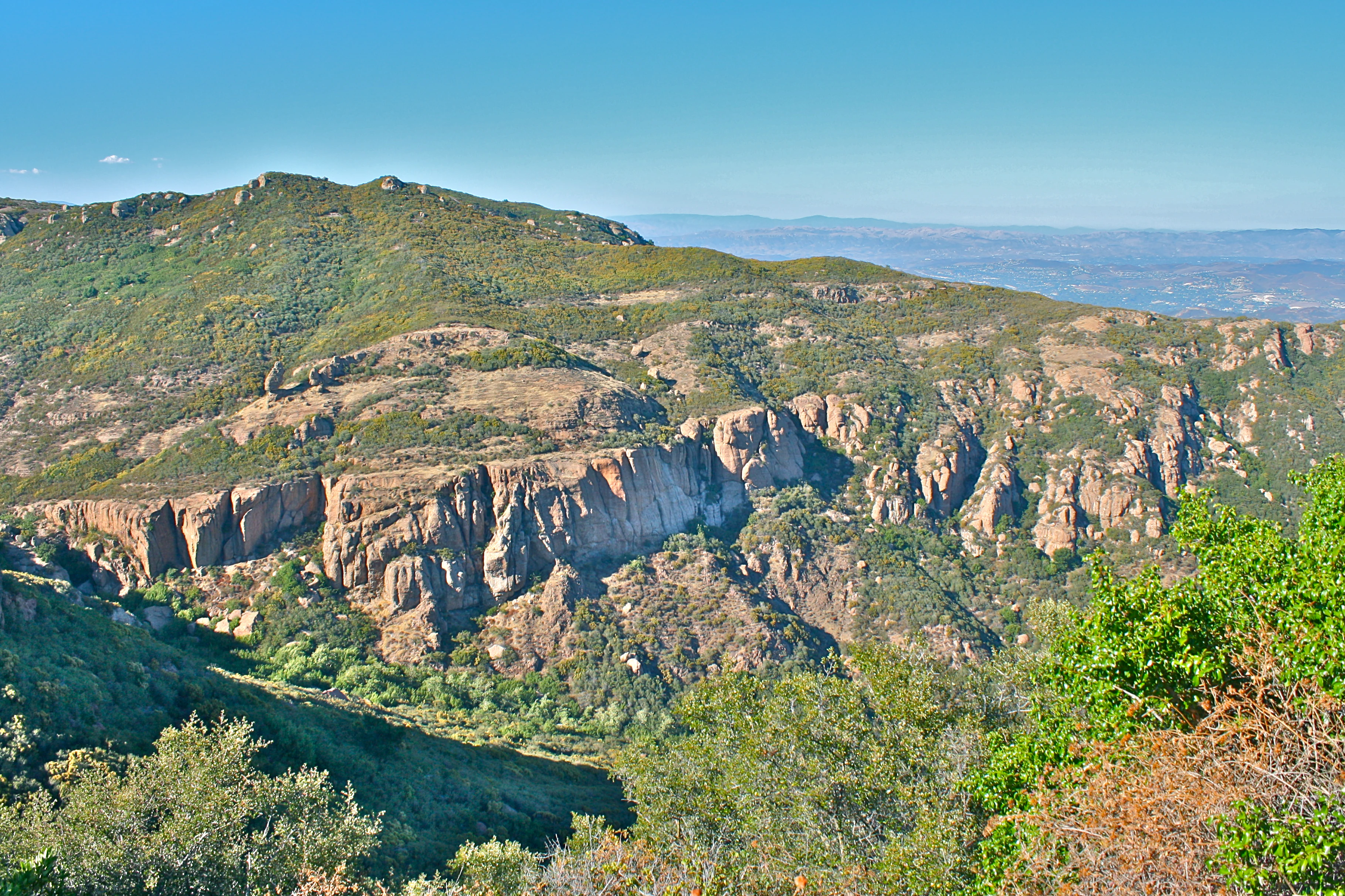
A wide landscape view of rocky sandstone cliffs and green hills under a clear blue sky, with a hazy valley visible in the background.
View of the Backbone Trail near Mishe Mokwa, showing rocky sandstone cliffs and the Conejo Valley in the distance.

Santa Monica Mountains National Recreation Area history and protected-area timeline

Efforts to protect the Santa Monica Mountains stretch back more than a century before the recreation area's formal establishment. In the early 1900s, landowner Frederick H. Rindge and the California State Mining Bureau each attempted to have parts of the range set aside as a forest reserve, but those early proposals were blocked by opposition from local mining interests and the limited amount of public land then available in the mountains.

Through the 1920s and 1930s, competing visions for the range shaped local politics. Limestone discoveries behind Pacific Palisades triggered a fight between developers led by Alphonzo Bell Sr. and conservationists led by Sylvia Morrison, while advocates including Frederick Law Olmsted Jr. sketched grander plans for a connected network of beaches, playgrounds, parks, and forests across greater Los Angeles. May Rindge, Frederick's widow, later proposed exchanging her bankrupt mountain holdings for cancellation of unpaid taxes, but the county declined.

By the 1960s and 1970s, momentum grew around creating a national park in the range, with several Toyon National Park bills introduced in Congress, including one by Representative Alphonzo Bell Jr. in 1971. State-level acquisitions during this period also laid the groundwork: Will Rogers State Historic Park became the first state park in the range in 1944, Point Mugu State Park expanded through major purchases in the late 1960s and 1970s, and Malibu Creek State Park was assembled from former movie ranch lands including parcels once owned by Ronald Reagan and Bob Hope. Topanga State Park opened in 1974 from acreage that reached from Pacific Coast Highway up to Mulholland Drive.

In 1964, conservationist Susan B. Nelson helped organize Friends of the Santa Monica Mountains, Parks and Seashore, building the constituency that would ultimately push Congress to establish the recreation area. On November 10, 1978, SMMNRA was formally created with a strategy of acquiring land in pieces to link habitats and expand existing parklands. The Santa Monica Mountains Conservancy, created in the 1980s, accelerated that strategy, adding key parcels including Rancho Sierra Vista and Paramount Ranch, while later acquisitions brought the Upper Las Virgenes Canyon Open Space Preserve and the King Gillette Ranch visitor center area into the system.

More recently, the recreation area has been shaped by major wildfires and ambitious infrastructure. The 2018 Woolsey Fire burned across much of SMMNRA, damaging historic structures including Paramount Ranch. In response to long-running studies of how U.S. 101 fragments wildlife populations, the Wallis Annenberg Wildlife Crossing at Liberty Canyon has been constructed as a vegetated overpass to reconnect mountain lion, bobcat, and other animal movements across the freeway.

Santa Monica Mountains National Recreation Area landscape and geographic character

The Santa Monica Mountains form a rugged, east-west trending range that steps abruptly from the Pacific Ocean inland toward the Los Angeles basin. Their position within the Transverse Ranges gives them a distinctive character compared to California's more common north-south mountain systems, producing bold ridgelines, deep canyons, and dramatic coastal cliffs within a relatively compact footprint.

The terrain alternates between steep sandstone and shale slopes, broad grassy plateaus, oak-shaded canyons, and exposed coastal promontories such as Point Dume. Creek systems such as Malibu Creek, Topanga Creek, and Las Virgenes Creek have carved through the range over geologic time, leaving behind riparian galleries of sycamore and willow that contrast sharply with the surrounding dry slopes. On the inland side, the southeastern flanks contribute to the Los Angeles River watershed, linking the mountains to one of Southern California's most important water systems.

Along the coast, SMMNRA encompasses broad sandy beaches, narrow pocket coves, rocky intertidal zones, and estuarine lagoons where freshwater creeks meet the sea. Inland, the landscape softens into rolling chaparral hills and former ranching flats, including the Simi Hills extension that connects the recreation area into southeastern Ventura County. This variety of landforms within a single protected unit is a defining feature of the recreation area's visual identity.
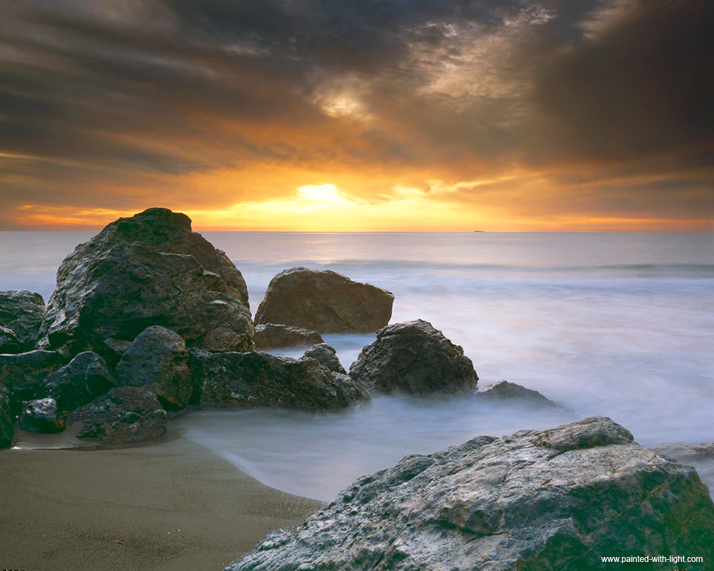
Large dark rocks sit on a sandy beach with smooth misty water and a dramatic orange and grey sunset sky.
Long exposure sunset view of large rocks on a sandy beach at Point Dume.

Santa Monica Mountains National Recreation Area ecosystems, habitats, and plant life

SMMNRA conserves one of the finest examples of a Mediterranean climate ecosystem remaining in North America. Its defining moisture pattern of mild, wet winters and long, dry summers supports a vegetation mosaic dominated by chaparral, coastal sage scrub, oak woodland, and riparian forest, each adapted to fire, drought, and periodic disturbance.

Chaparral slopes are characterized by dense, shrubby stands of species such as chamise, manzanita, and California buckwheat, while coast live oak woodlands cluster in moister draws and on north-facing hillsides. Along creeks and around springs, willows, sycamores, and cottonwoods create shade-rich ribbons of habitat that are disproportionately important for wildlife movement and breeding. Smaller patches of native grassland and savanna also persist, often where grazing history and fire patterns have shaped the open character of the land.

Because these communities have evolved alongside fire, periodic burning plays a natural role in maintaining ecosystem structure, although the scale and intensity of recent wildfires, including the 2018 Woolsey Fire, have raised new questions about resilience in a warming climate. The recreation area's mosaic of habitat types, stitched across ownership boundaries, also makes it a critical refuge and stepping stone for species that would otherwise be isolated by urbanization.
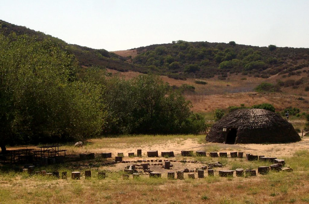
A landscape view showing a traditional Native American dome-shaped structure made of natural materials alongside a circular arrangement of wooden post stumps, with chaparral-covered hills in the background
The Satwiwa Native American Indian Culture Center featuring a traditional dome-shaped dwelling and circular post arrangement in the Santa Monica Mountains

Santa Monica Mountains National Recreation Area wildlife and species highlights

SMMNRA supports an unusually rich array of wildlife for a protected area embedded in a major metropolitan region. Its mountains, canyons, creeks, beaches, and ocean edges together harbor mammals, birds, reptiles, and marine life characteristic of both the California chaparral zone and the Southern California coast.

Among large mammals, the recreation area is famous for its population of mountain lions, which have been studied intensively because their movements are blocked and fragmented by U.S. 101 and other roads. Bobcats, coyotes, and mule deer are widespread, and black bears have recolonized the range in small numbers in recent decades. Smaller mammals such as gray foxes, raccoons, opossums, and numerous rodent and bat species fill out the community.

Birdlife is especially diverse, with raptors like red-tailed hawks and great horned owls hunting over open slopes, and a wide range of songbirds, woodpeckers, and hummingbirds occupying oak and riparian woodlands. The coast adds seabirds, shorebirds, and seasonal migrants, while creeks and lagoons provide habitat for herons, egrets, and in some seasons steelhead trout using Malibu Creek and other waterways. The Wallis Annenberg Wildlife Crossing at Liberty Canyon represents the latest effort to maintain connectivity for these species across one of Southern California's busiest transportation corridors.
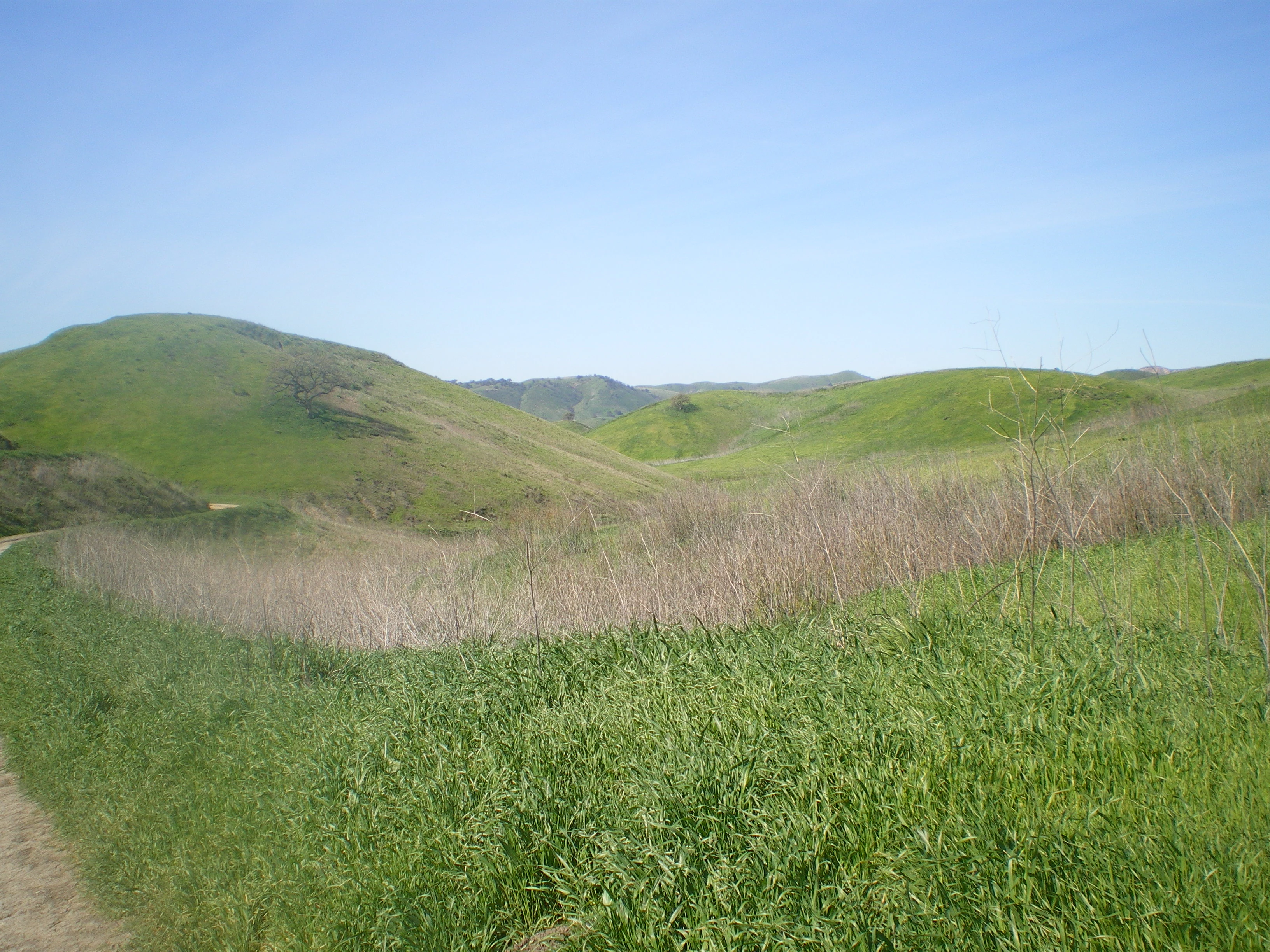
A wide landscape view of rolling green hills under a clear blue sky, with a dirt trail visible in the bottom left corner and dry brush in the midground.
Rolling green hills and grasslands at Upper Las Virgenes Canyon under a clear blue sky.

Santa Monica Mountains National Recreation Area conservation status and protection priorities

SMMNRA's conservation importance rests on its role as a large, connected refuge in one of the most urbanized regions of the United States. By knitting together federal, state, local, university, and privately conserved lands, the recreation area maintains ecological functions that would be impossible within a single conventional park boundary.

A central focus of conservation work is preserving habitat connectivity across U.S. 101 and other major roads. Long-term tracking of bobcats, mountain lions, and more recently black bears has shown how freeways isolate animal populations, limit genetic exchange, and increase mortality. The Wallis Annenberg Wildlife Crossing at Liberty Canyon is the highest-profile response, designed to reopen a safe passage for wildlife over the highway.

Beyond connectivity, the recreation area plays a key role in protecting one of North America's most intact Mediterranean climate ecosystems, including chaparral and oak woodland communities that are globally restricted and increasingly threatened by development, altered fire regimes, and climate stress. Partner agencies and conservancies also manage threats from invasive species, recreational pressure, and post-fire recovery. The Rim of the Valley Corridor Special Resource Study reflects ongoing efforts to expand the conservation footprint to include the surrounding San Fernando, Crescenta, Santa Clarita, Simi, and Conejo valleys, potentially adding hundreds of thousands of additional acres to the protected landscape.

Santa Monica Mountains National Recreation Area cultural meaning and human context

The Santa Monica Mountains carry a cultural record that reaches back more than ten thousand years. The western portion of the recreation area lies within the traditional homelands of the Chumash people, while the eastern sections are associated with the Tongva. Their presence is marked today by numerous archaeological sites, including pictograph sites, village locations, and habitation areas scattered through the canyons and along the coast. Satwiwa, a native cultural center within SMMNRA, reflects ongoing indigenous connections to this landscape.

Later waves of history left their own imprint. Spanish and Mexican-era land grants created large ranchos across the range, and several former ranching properties, including Rancho Sierra Vista, remain part of the recreation area. The twentieth century brought Hollywood filmmaking into the mountains, with ranches such as Paramount Ranch used as outdoor studio lots; the 2018 Woolsey Fire severely damaged Paramount Ranch, underscoring how recent this legacy is.

Today, SMMNRA also hosts museums, historic homes such as the Adamson House, California Historical Landmarks, and visitor centers where partners work to interpret these layered histories alongside the area's natural systems. The Santa Monica Mountains Fund supports National Park Service and California State Parks programming that ties conservation, recreation, and cultural understanding together.
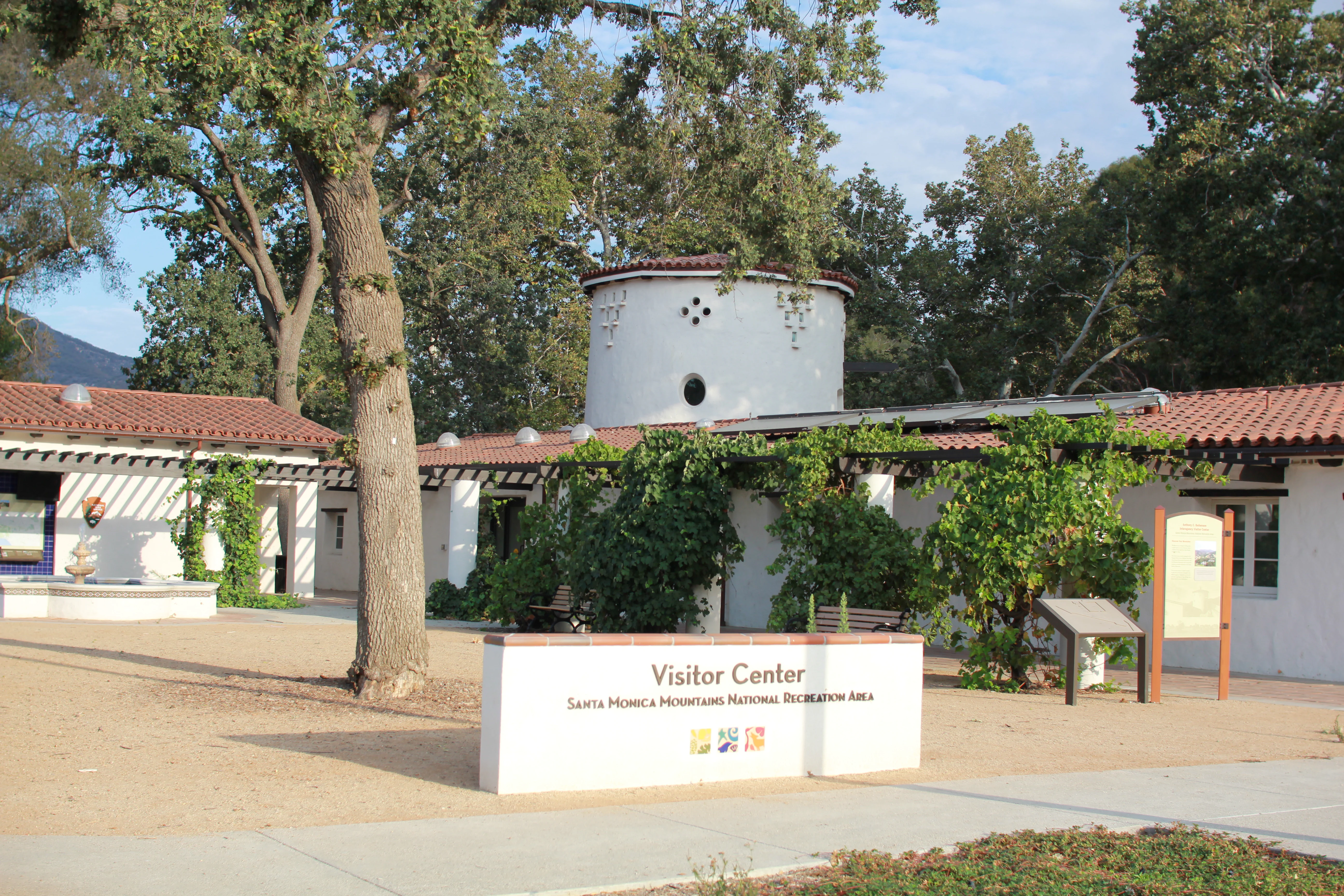
A white single-story building with a red tile roof and a cylindrical tower, featuring a large white sign in the foreground reading 'Visitor Center Santa Monica Mountains National Recreation Area'.
Exterior view of the Anthony C. Beilson Interagency Visitor Center with a prominent sign.

Top sights and standout views in Santa Monica Mountains National Recreation Area

SMMNRA's most distinctive quality is the way it places a Mediterranean ecosystem, an archaeological treasure trove, and a working series of parks and beaches directly adjacent to one of America's largest metropolitan regions. Few protected areas anywhere combine wilderness-scale ecological function with such immediate urban access.

Key highlights include the Backbone Trail and its long ridgeline traverse of the range, the scenic canyons and creek systems of Malibu Creek State Park and Topanga State Park, and the dramatic Pacific coastline from Point Dume down to Zuma Beach. Culturally, the recreation area is anchored by places such as Satwiwa, Paramount Ranch, the Adamson House, and the Will Rogers State Historic Park, each representing a different chapter of the mountains' human story.

The recreation area is also notable for its role in modern conservation science: long-running mountain lion and bobcat research led directly to the construction of the Wallis Annenberg Wildlife Crossing at Liberty Canyon, making SMMNRA a benchmark for urban wildlife connectivity work in North America.
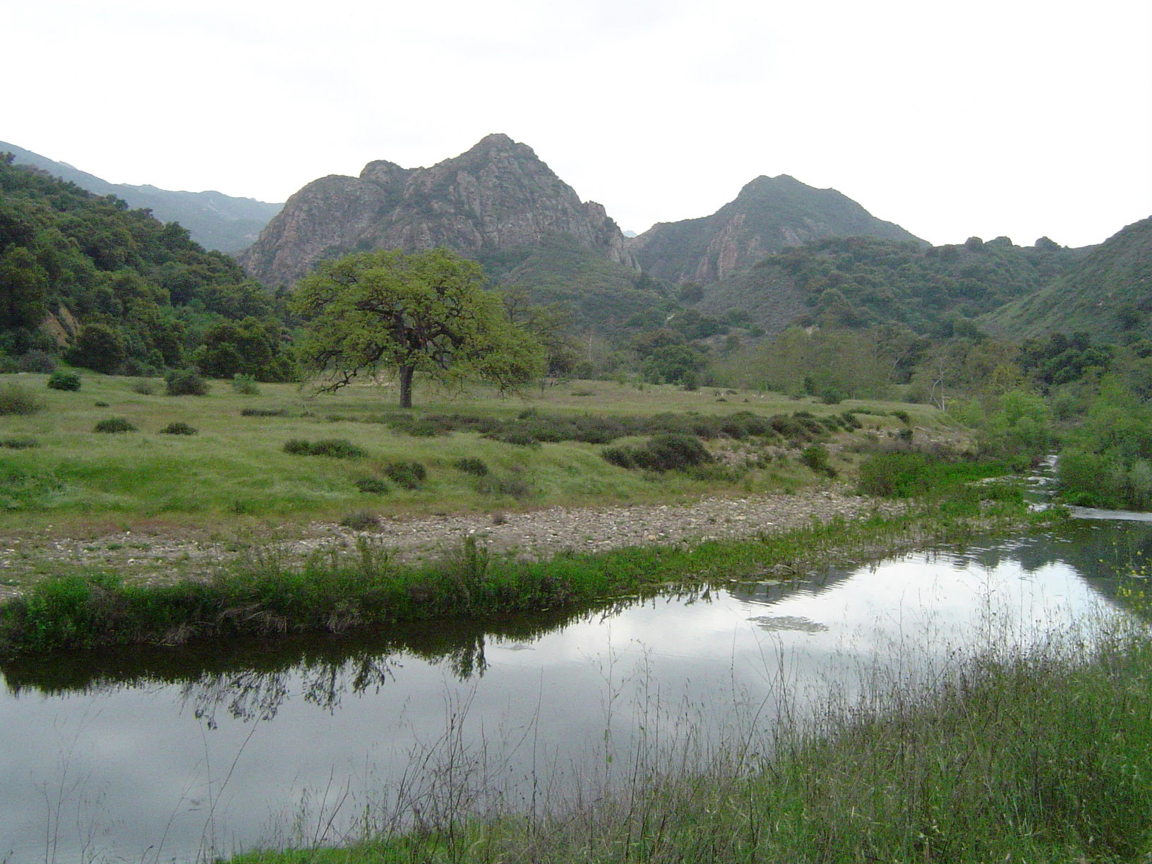
A landscape photograph showing a calm creek reflecting the sky in the foreground, a grassy field with a large oak tree in the midground, and rugged rocky mountain peaks in the background.
A valley oak stands in a grassy meadow beside Malibu Creek, with the rocky Goat Buttes peaks rising in the background.

Best time to visit Santa Monica Mountains National Recreation Area

Because SMMNRA spans coast, canyon, and ridge, its character shifts meaningfully with the seasons. Late winter and spring are typically the greenest and most floristically rich periods, when chaparral shrubs bloom, creeks run, and wildflowers can carpet open slopes after wet years. Cooler temperatures and softer light also make this a comfortable time for long hikes on routes such as the Backbone Trail.

Summer brings dry, golden hills and reliably warm beach weather along the Malibu coast, though inland canyons can become very hot. This is also the season when wildfire risk is highest, and visitors should be prepared for smoke, closures, and rapidly changing conditions during fire weather. Fall often returns clear skies, cooler nights, and dramatic light over the chaparral slopes, with fewer crowds than the busy spring weekends. Wildlife watching can be rewarding year-round, but cooler months tend to concentrate animal activity near water and along ridgelines, making them productive for quiet observation.
Monthly climate preview

Examine long-term average temperature ranges and precipitation patterns across the year

Santa Monica Mountains National Recreation Area Climate Normals and Weather by Month

Representative coordinates record mean monthly temperatures spanning from 13.34 to 22.07 degrees Celsius alongside distinct precipitation variations across twelve recorded intervals. Accessing the comprehensive profile provides complete monthly data points for analyzing detailed thermal rhythms and rainfall averages.
Annual mean17 °C
13 °C22 °C
Jan13°
Feb13°
Mar14°
Apr16°
May17°
Jun19°
Jul21°
Aug22°
Sep22°
Oct20°
Nov16°
Dec13°
Warmest month
August

22.1 °C

Coolest month
January

13.3 °C

Wettest month
February

3.7 mm/day

Driest month
August

0 mm/day

Park location guide

Geography guide, regional context, and park location map for Santa Monica Mountains National Recreation Area

Santa Monica Mountains National Recreation Area park geography, regions, and map view in United States of America

Understand where Santa Monica Mountains National Recreation Area sits in United States of America through a broader geographic reading of the surrounding landscape, nearby location context, and its mapped position within the national park landscape.

How Santa Monica Mountains National Recreation Area fits into United States of America

The United States of America is a federal presidential republic and one of the world's largest countries by area and population. It consists of 50 states across a vast territory spanning multiple time zones, with its capital in Washington, D.C. and largest city in New York City. The nation has a diverse economy, influential political system, and significant cultural and military presence globally.

Wider geography shaping Santa Monica Mountains National Recreation Area in United States of America

The United States occupies a vast territory in North America, bordered by Canada to the north and Mexico to the south. The 48 contiguous states stretch from the Atlantic to the Pacific Ocean, while Alaska occupies the northwestern region and Hawaii is an archipelago in the Pacific. The country encompasses diverse terrain including the Rocky Mountains, Appalachian Mountains, Great Plains, and extensive river systems.

Map view of Santa Monica Mountains National Recreation Area

Use this park location map to pinpoint Santa Monica Mountains National Recreation Area in United States of America, understand its exact geographic position, and read its mapped placement within the surrounding landscape more clearly.

Pigeon | © OpenStreetMap contributors

Location context for Santa Monica Mountains National Recreation Area

California
Recorded earthquake history

Review Recorded Seismic Events Near Santa Monica Mountains National Recreation Area

Browse an organized record of historical earthquakes associated with the Santa Monica Mountains National Recreation Area. These data points provide a clearer understanding of seismic occurrences within the region, allowing for an exploration of recorded event locations, magnitudes, and depths across the park geography through MoriAtlas.

Santa Monica Mountains Earthquake History

Catalogued events

1,414 events

Strongest magnitude

Magnitude 6.7

Most recent event

Sep 6, 2026

This history includes earthquakes recorded inside the park or within 50 km of its borders

Visual reference of Mediterranean habitats, coastal bluffs, and rugged mountain terrain

Santa Monica Mountains National Recreation Area Photos and Landscape Scenery

Visual documentation of Santa Monica Mountains National Recreation Area reveals the rugged terrain, chaparral slopes, and oak woodlands defining this protected coastal range. Examining park photography provides a clearer understanding of the diverse ecosystems and dramatic topography stretching from the Pacific shoreline inland toward the Los Angeles basin.

A wide landscape view of rocky sandstone cliffs and green hills under a clear blue sky, with a hazy valley visible in the background.

A mountain lion with a tracking collar stands on rocky ground in front of a dark concrete tunnel entrance, with a discarded tire visible to the left.

Large dark rocks sit on a sandy beach with smooth misty water and a dramatic orange and grey sunset sky.

A landscape view showing a traditional Native American dome-shaped structure made of natural materials alongside a circular arrangement of wooden post stumps, with chaparral-covered hills in the background

A wide landscape view of rolling green hills under a clear blue sky, with a dirt trail visible in the bottom left corner and dry brush in the midground.

A rocky mountain peak with large boulders and green shrubs under a cloudy sky.

A white single-story building with a red tile roof and a cylindrical tower, featuring a large white sign in the foreground reading 'Visitor Center Santa Monica Mountains National Recreation Area'.

A landscape photograph showing a calm creek reflecting the sky in the foreground, a grassy field with a large oak tree in the midground, and rugged rocky mountain peaks in the background.

A medium-sized green shrub with dense oval-shaped leaves and reddish stems, growing outdoors among rocks and dry grass with a wire mesh fence visible in the background.

A weathered wooden sign reading 'RANCHO SIERRA VISTA' mounted on two posts in a dry grassy field, with a mountain ridge and clear blue sky in the background.

A wide landscape view showing white buildings with red roofs, a tennis court, and palm trees situated in a green valley surrounded by rolling hills and mountains.

Park atlas

Compare regional protected areas and connected coastal mountain landscapes across Southern California.

Parks Near Santa Monica Mountains National Recreation Area and Surrounding Protected Lands

Browse other parks near Santa Monica Mountains National Recreation Area to examine related chaparral habitats and coastal ecosystems. Comparing these adjacent protected landscapes provides a clearer picture of regional geography and wildlife connectivity.
Marine protected areaCalifornia
15 km away#1 closest

West

Channel Islands National Marine Sanctuary Marine Protected Area Map and Atlas

Southern California marine habitat and island topography

Channel Islands National Marine Sanctuary protects 1,470 square miles of diverse marine environment near the California coast. This sanctuary guards vital kelp forests and deep seafloor ecosystems while preserving deep water archaeological sites and the biological legacy of the Northern Channel Islands.

Area
3,807 km²
Established
1980
IUCN
V
Relief
Lowland
A soft, painterly watercolor illustration depicting layered green mountain ridges and rolling foothills under a bright, open sky.
Protected landscapeCalifornia
16 km away#2 closest

Northeast

Angeles National Forest: Mapped Protected Landscapes and Geographic Terrain in California

Mountain wilderness and Mediterranean watershed geography

Spanning the San Gabriel and Sierra Pelona ranges, Angeles National Forest serves as a dramatic ecological transition zone. This analysis of its protected landscape focuses on the interaction between steep canyons, high peaks, and the distinct chaparral and conifer zones that shape California geography.

Area
2,652.26 km²
Established
1908
Relief
Mountain
Climate
Mediterranean
National parkCalifornia
22 km away#3 closest

West

Channel Islands National Park: A Protected Landscape within California's Geography

Explore its unique mapped terrain and protected area context.

Channel Islands National Park stands as a key protected area, providing critical insight into California's unique geographic features and natural landscapes. This entry focuses on the park's identity as a protected entity, detailing its mapped boundaries and the surrounding regional geography. It offers an atlas-level view, essential for understanding the park's contribution to the broader landscape context of the United States and its conservation importance.

Area
1,009.94 km²
Established
1980
IUCN
II
Visitors
323.2K annual
Watercolor painting of a mountain landscape with forested foothills and a valley in the foreground.
Protected landscapeCalifornia
27 km away#4 closest

Northwest

Los Padres National Forest: Geography and Protected Landscape Map of Central California

Extensive wilderness corridors and high mountain ridges

Spanning from the Big Sur coastline to the interior ranges of the Santa Lucia and San Rafael mountains, Los Padres National Forest represents a significant protected area in California. The region contains deep gorges, forest-covered canyons, and high-altitude pine ridges that provide essential habitat and support major river headwaters.

Area
7,700 km²
Established
1936
Relief
Mountain
Climate
Mediterranean
Watercolor painting of a mountain landscape with rolling green hills and small evergreen trees, with soft purple mountain silhouettes in the distance.
Protected landscapeCalifornia
63 km away#5 closest

East

San Bernardino National Forest: Geography and Protected Landscape Atlas

Transverse and Peninsular mountain ranges in California

Spanning over 820,000 acres, San Bernardino National Forest offers a look at one of Southern California's most significant protected landscapes. The forest features seven wilderness areas and a dramatic range of elevation, moving from arid chaparral to old-growth mixed conifer forests. Our geographic mapping traces the unique structure of four intersecting mountain ranges, detailing the terrain from deep canyons to high alpine peaks.

Area
3,333.87 km²
Established
1907
Relief
Mountain
Climate
Mediterranean
Watercolor painting of a mountain range with a winding stream, small trees, and grassy foreground on a white background.
Wildlife reserveCalifornia
About 74 km away#6 closest

Northwest

Matilija Wilderness: A High Elevation Protected Landscape in the Santa Ynez Mountains

Rugged canyon geography and critical California condor habitat

Spanning from deep canyon bottoms to the high rocky ridges of Monte Arido, Matilija Wilderness represents a significant protected unit within California. The area encompasses a dense network of riparian habitats along Matilija Creek, forming a vital ecological corridor for wildlife and preserving the rugged terrain of the southern Santa Ynez Mountains.

Area
118.2 km²
Established
1992
IUCN
Ib
Relief
Mountain
A horizontal watercolor painting depicting a wide, winding river flowing through a coastal valley with rolling hills in the background and sparse green vegetation in the foreground.
Marine protected areaCalifornia
83 km away#7 closest

West

Chumash Heritage National Marine Sanctuary: California Marine Protected Area Atlas

Mapping coastal transition zones and submarine seafloor features

Spanning over 4,500 square miles off the Central Coast of California, the Chumash Heritage National Marine Sanctuary represents a critical ecological intersection between northern and southern marine species. The sanctuary includes dramatic underwater terrain like Arguello Canyon, Rodriguez Seamount, and the Santa Lucia Bank, creating a complex habitat that sustains kelp forests and diverse maritime resources.

Area
11,770 km²
Established
2024
IUCN
V
Relief
Mixed relief
Watercolor painting of a panoramic mountain landscape with stylized pine trees and soft green meadows.
Protected landscapeCalifornia
132 km away#8 closest

North

Sequoia National Forest: Protected Sierra Nevada Geography and Mountain Terrain

A vast protected landscape spanning 1.1 million acres in California

Spanning Tulare, Kern, and Fresno counties, Sequoia National Forest preserves iconic giant sequoia groves across multiple river watersheds. The terrain features vertical relief exceeding 11,000 feet, showcasing a range of ecosystems from chaparral slopes and coniferous forests to glacial cirques and granite spires located within the southern Sierra Nevada range.

Area
4,829.17 km²
Established
1908
Relief
Mountain
Climate
Mediterranean

Common questions about visiting, size, designation, and location context for Santa Monica Mountains National Recreation Area

Santa Monica Mountains National Recreation Area FAQs for park facts, access, geography, and protected area context

Find quick answers about Santa Monica Mountains National Recreation Area, including protected-area facts, park geography, trail and visitor context, and how the park fits into its surrounding country and regional landscape.
MoriAtlas Explorer

Continue Your Protected Areas Search Across the Global Atlas

Deepen your exploration by continuing the structured search for national parks and protected areas worldwide. Utilize the comprehensive filtering capabilities to compare different conservation landscapes and refine your understanding of global park geography. Discover more about the distribution and characteristics of protected natural areas.

Global natural geography