

Mori Atlas logo
National parkSatpura National Park

Discover the mapped boundaries and regional context of this Indian national park.

Satpura National Park: India's Protected Landscape and Geographic Atlas Entry

(Satpura Tiger Reserve)

Satpura National Park stands as a key protected area within India's diverse geography. This entry focuses on its identity as a national park, providing detailed insights into its mapped boundaries and landscape context. Explore Satpura National Park to understand its place within the atlas of protected lands and its unique geographic features within the Indian subcontinent.

tiger reservenational parkcentral IndiaMadhya Pradeshwildlife sanctuarytiger conservation

Satpura National Park

National park

Park overview

Structured park overview, official facts, and landscape profile for Satpura National Park

Satpura National Park park facts, protected area profile, and essential visitor context

Review the core facts for Satpura National Park, including designation, size, terrain, visitor scale, habitats, and operating context in one park-focused overview.

About Satpura National Park

Satpura National Park forms the core of the larger Satpura Tiger Reserve in the heart of Madhya Pradesh, India's central state. The reserve gets its name from the Satpura Range, a series of seven mountains that create the distinctive hilly backdrop of this protected area. The national park was formally established in 1981, though the region had been recognized as a reserved forest since the 19th century due to its ecological and commercial importance. The reserve spans 2,133 square kilometers, with the national park proper covering 524 square kilometers, complemented by the Bori and Pachmarhi wildlife sanctuaries. Located in the Narmadapuram district, the park lies within the central Indian highlands, a region of significant biogeographic importance. The landscape is characterized by rugged terrain featuring sandstone peaks, narrow gorges, and ravines, with elevation ranging from the nearly level plains of Churna to the 1,350-meter Dhoopgarh peak. The Tawa River flows through the park, and the Tawa reservoir has been created on this watercourse, adding aquatic and wetland habitats to the reserve's diversity. The park is governed by the Madhya Pradesh Forest Department under the Ministry of Environment, Forest and Climate Change, with visitor access managed through the official Satpura Tiger Reserve website.

Quick facts and research context for Satpura National Park

Satpura National Park covers 524 square kilometers within a larger tiger reserve spanning 2,133 square kilometers in Madhya Pradesh, India. The terrain features elevations ranging from 300 to 1,352 meters, with Dhoopgarh peak rising to 1,350 meters. The Tawa River flows through the park, and the landscape includes sandstone peaks, narrow gorges, ravines, and dense forests. The park experiences a subtropical climate with summer temperatures reaching 40°C, monsoon rainfall of 1,300-1,700mm, and winter temperatures dropping to 1°C. The reserve contains over 1,300 plant species and supports 50 mammal species, 254 bird species, 30 reptile species, and 50 butterfly species.

Protection and recognition

Verifying the terrestrial management scope and historical framework established in the year 2000

Satpura National Park Protection Status and Conservation Designation

Detailed records map the terrestrial protection status of Satpura National Park to clarify its official conservation boundaries. Tracking the historical designation from the year 2000 provides a reliable framework for understanding the region's formal ecological management.

Protection details

Protection scope
Terrestrial
Designated year
2000
Transboundary protection
No
Park context

Deeper park guide and search-rich context for Satpura National Park

Satpura National Park history, landscape, wildlife, and travel context

Explore Satpura National Park through its history, landscape character, ecosystems, wildlife, conservation priorities, cultural context, and seasonal travel timing in a structured park guide built for atlas discovery and search intent.

Why Satpura National Park stands out

Satpura National Park is best known as a premier tiger reserve in central India, protecting one of the country's most significant populations of Bengal tigers within a rugged mountain landscape. The park is renowned for its diverse mammal population including leopards, gaurs, sambar deer, barasingha (swamp deer), and four-horned antelope. Its botanical diversity is equally notable, with over 1,300 plant species including extensive sal forests, teak woodlands, and rare endemic plants. The landscape of sandstone peaks, deep gorges, and the Tawa River valley creates a distinctive setting among India's tiger reserves, while the Pachmarhi plateau within the reserve adds further ecological and scenic diversity.

Satpura National Park history and protected-area timeline

The history of Satpura National Park begins with its exploration in 1862 by Captain James Forsyth, who ventured into the region while searching for the Indian freedom fighter Tatya Tope. Forsyth's exploration of this forested hill region marked the beginning of documented understanding of the area's ecological significance. The region was among the first declared Reserved Forest Areas of India, a designation that reflected both its ecological importance and the commercial value of its timber resources. The formal establishment of Satpura National Park occurred in 1981, creating legal protection for the core area of what would later become a larger conservation landscape. In 2000, the area was declared a tiger reserve, elevating its conservation status and bringing additional resources for protection and management. The reserve has continued to develop its conservation program, including the reintroduction of barasingha (swamp deer) from Kanha Tiger Reserve, with 98 individuals introduced in 2015 and the population growing to approximately 200 by 2024. The region also benefited from village relocations, with 23 villages moved from the core area to create additional grassland habitat and reduce human-wildlife conflict.

Satpura National Park landscape and geographic character

The landscape of Satpura National Park is defined by its location within the Satpura Range of central India, a region of rugged hills and forested valleys. The terrain features sandstone peaks that rise dramatically from the surrounding terrain, interspersed with narrow gorges, deep ravines, and the more level plains of Churna on the northern side. The elevation ranges from approximately 300 meters in the lower areas to 1,352 meters at the highest points, with Dhoopgarh peak standing at 1,350 meters as one of the prominent landmarks. The park's topography creates diverse microhabitats, from steep rocky slopes to more gentle valleys where watercourses have carved their way through the landscape. The Tawa River flows through the park, providing an important water source and creating riparian habitats along its course. The Tawa reservoir, constructed on this river, adds a significant aquatic element to the landscape. The Pachmarhi plateau, located within the wider reserve, represents another distinctive landscape element, featuring higher elevations and unique geological formations. The combination of hills, valleys, rivers, and reservoirs creates a visually varied landscape that supports the diverse ecological communities found within the reserve.

Satpura National Park ecosystems, habitats, and plant life

Satpura National Park sits within a Central Indian forest ecosystem that is recognized for its exceptional biodiversity. The park contains over 1,300 species of plants, including prominent tree species such as sal, teak, tendu, mahua, and bel, along with extensive bamboo stands. The botanical diversity includes 62 tree species, 30 small tree species, 58 shrub species, 32 climber species, and approximately 64 grass species. The vegetation varies with elevation and aspect, with sal forests dominating the Pachmarhi plateau while teak forests on basaltic traps characterize the lower northern plains. The park is notable for containing important medicinal plants and rare endemic species from genera including Psilotum, Cyathea, Osmunda, Lycopodium, and Lygodium, some of which are found only in Satpura within Madhya Pradesh. Approximately 10% of the reserve area consists of grasslands, including natural blanks on the Pachmarhi plateau, anthropogenic grasslands created by village relocations, and areas around the Tawa reservoir drawdown zone. These grasslands, named Neemghan, Madai, Keria, Dhain, and Geetkheda, are actively maintained to support populations of herbivores. The moist conditions and diverse flowering plants also support a rich butterfly fauna, with approximately 50 species including the oakleaf, black rajah, and great eggfly.

Satpura National Park wildlife and species highlights

Satpura National Park supports a remarkable diversity of wildlife within its forest and grassland habitats. The mammal population includes approximately 50 species, with tigers and leopards representing the apex predators. The prey base is robust, supporting populations of spotted deer, sambar deer, gaur, nilgai, Indian muntjac, four-horned antelope, chinkara, black buck, barasingha, and mouse deer. The reserve also hosts smaller carnivores including dholes (wild dogs), sloth bears, and pangolins. Other notable mammals include wild boar, porcupines, Indian giant squirrels, flying squirrels, rhesus monkeys, and langurs. The bird fauna is equally impressive, with 254 species recorded including hornbills, peafowl, crested serpent eagles, owls, crow pheasants, Malabar whistling thrush, paradise fly-catcher, honey buzzard, and Malabar pied hornbills. Reptiles are represented by approximately 30 species, including marsh crocodiles. The barasingha (swamp deer) represents a particular conservation success story, with 98 individuals reintroduced from Kanha Tiger Reserve in 2015 and the population growing to approximately 200 by 2024.

Satpura National Park conservation status and protection priorities

Satpura National Park functions as a critical component of India's tiger conservation landscape, designated as a Tiger Reserve in 2000 under the Project Tiger program. The reserve's conservation significance extends beyond tiger protection to encompass the broader Central Indian forest ecosystem, which supports numerous threatened and endemic species. The park's classification as IUCN Category II reflects its status as a national park with primary protection objectives. Conservation efforts include active management of grasslands through protection and maintenance, recognizing that these habitats support substantial herbivore populations and require intervention to prevent woody plant encroachment. The reintroduction of barasingha from Kanha Tiger Reserve demonstrates ongoing efforts to restore native species populations. The reserve also addresses human-wildlife conflict through village relocations from the core area, reducing pressure on natural resources and creating additional protected habitat. The governance structure involves both the Ministry of Environment, Forest and Climate Change and the Madhya Pradesh Forest Department, providing institutional framework for long-term conservation management.

Satpura National Park cultural meaning and human context

The cultural context of Satpura National Park is rooted in the historical relationship between the region and its indigenous communities, though the park's primary identity centers on wildlife conservation rather than explicit cultural heritage sites. The name Satpura itself derives from Sanskrit, with sapta meaning seven and pura meaning mountain, reflecting the range of hills that give the region its distinctive character. The area's exploration by British officers in the 19th century, notably Captain James Forsyth in 1862, marked the beginning of documented interaction between colonial administration and this forested landscape. The region's earlier designation as a Reserved Forest Area reflected administrative recognition of its ecological and commercial resources. While the park itself does not emphasize major cultural monuments or archaeological sites, the surrounding region of Madhya Pradesh contains rich tribal and historical heritage, and the park's buffer zones interact with communities whose traditional practices are intertwined with the forest environment. The Pachmarhi area within the wider reserve has developed as a hill station with historical British-era architecture, adding a cultural dimension to the broader landscape.

Top sights and standout views in Satpura National Park

Satpura National Park stands out among India's protected areas for its combination of rugged mountain terrain, substantial tiger population, and exceptional botanical diversity within the central Indian highlands. The park offers visitors the opportunity to explore a landscape quite different from the savanna ecosystems more commonly associated with Indian tiger reserves, with its sandstone peaks, deep gorges, and dense forests creating a distinctive setting. The presence of the Tawa River and reservoir adds aquatic habitats not found in all tiger reserves, supporting species like marsh crocodiles and providing additional wildlife viewing opportunities. The barasingha reintroduction program represents a conservation success story, with the population growing from 98 individuals in 2015 to approximately 200 in 2024. The diverse mammal community includes several species of conservation concern, while the bird and butterfly fauna add further appeal for nature enthusiasts. The park's relatively less-visited status compared to some other Indian tiger reserves offers a more remote and wilderness-focused experience for those seeking to explore central India's natural heritage.

Best time to visit Satpura National Park

The best time to visit Satpura National Park depends on the experience sought, with different seasons offering distinct advantages. The winter months from November to February represent the most popular period for wildlife viewing, as temperatures are comfortable, wildlife is more active during cooler hours, and the landscape remains green from the monsoon season. Morning temperatures can drop to around 4°C in higher areas like the Pachmarhi plateau, with daytime temperatures reaching approximately 15°C, while the park's lower areas experience slightly warmer conditions. The summer months from March to June offer different opportunities, though temperatures can reach 40°C during the day, making early morning game drives essential. The monsoon season from July to October brings heavy rainfall, with the landscape at its lushest and greenest, though some areas may be less accessible and wildlife viewing can be more challenging. The post-monsoon period in November often provides excellent conditions as the weather stabilizes and wildlife becomes more visible near water sources. Visitors should note that the park operates under seasonal closures, and specific opening dates should be confirmed with reserve authorities before planning a visit.
Monthly climate preview

Long-term representative point measurements tracking monthly temperature and precipitation rhythms

Satpura National Park Climate Normals and Annual Weather by Month

Historical data records multiyear temperature ranges and precipitation rates across a representative coordinate within Satpura National Park. Reviewing the complete monthly profile provides structured insight into long-term environmental patterns and climate normals.
Annual mean26 °C
19 °C35 °C
Jan19°
Feb22°
Mar27°
Apr32°
May35°
Jun31°
Jul27°
Aug25°
Sep25°
Oct24°
Nov22°
Dec19°
Warmest month
May

34.9 °C

Coolest month
January

19 °C

Wettest month
July

13.7 mm/day

Driest month
December

0.2 mm/day

Park location guide

Geography guide, regional context, and park location map for Satpura National Park

Satpura National Park park geography, regions, and map view in India

Understand where Satpura National Park sits in India through a broader geographic reading of the surrounding landscape, nearby location context, and its mapped position within the national park landscape.

How Satpura National Park fits into India

India is a South Asian country bordered by the Indian Ocean, Arabian Sea, and Bay of Bengal. It shares land borders with Pakistan, China, Nepal, Bhutan, Bangladesh, and Myanmar. The country has a population of over 1.4 billion people and operates as a federal parliamentary republic with its capital in New Delhi.

Wider geography shaping Satpura National Park in India

India occupies the Indian subcontinent in South Asia, bordered by the Arabian Sea to the southwest, the Bay of Bengal to the southeast, and the Indian Ocean to the south. It shares land borders with Pakistan to the west, China, Nepal, and Bhutan to the north, and Bangladesh and Myanmar to the east. The territory also includes the Andaman and Nicobar Islands in the Indian Ocean.

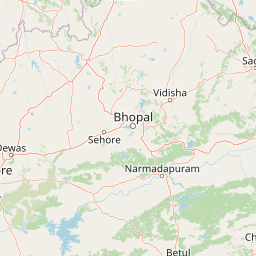
Map view of Satpura National Park

Use this park location map to pinpoint Satpura National Park in India, understand its exact geographic position, and read its mapped placement within the surrounding landscape more clearly.

Pigeon | © OpenStreetMap contributors
Park atlas

Trace the geographic spread of tiger reserves and forest ecosystems across central India's highlands, including Madhya Pradesh.

Explore Nearby National Parks and Protected Areas Beyond Satpura National Park

Discover a curated list of national parks and protected areas geographically connected to Satpura National Park, spanning diverse forest ecosystems and mountain landscapes across central India. Continue your atlas-style discovery by mapping regional conservation efforts, comparing park features, and understanding the broader distribution of protected landscapes in Madhya Pradesh.
National parkMadhya Pradesh
About 120 km away#1 closest

Northwest

Van Vihar National Park: National Park Protected Landscape and Regional Geography

Mapped boundaries within Madhya Pradesh's natural context.

Van Vihar National Park is a designated national park offering a unique perspective on protected landscapes within Madhya Pradesh. This detail entry provides essential geographic context, focusing on the park's mapped boundaries and its role within the region's natural terrain. It serves as a vital point for understanding the distribution and identity of protected areas for atlas exploration.

Area
4.48 km²
Established
1979
IUCN
II
Visitors
250K annual
National parkMadhya Pradesh
About 143 km away#2 closest

Southeast

Pench National Park: Madhya Pradesh National Park Protected Landscape Overview

Mapped geographic context and protected area boundaries

Pench National Park is a designated national park situated in Madhya Pradesh, India, offering a distinct protected landscape for geographic study. This entry provides detailed insights into its mapped terrain, allowing for an atlas-style exploration of its protected boundaries and its significance within the regional geography. Understand the park's place in the landscape and its value for conservation-focused map exploration.

Area
292.85 km²
Established
1983
IUCN
II
Relief
Upland
National parkMaharashtra
About 164 km away#3 closest

Southwest

Gugamal National Park: A National Park Within Maharashtra's Geographic Atlas

Explore its mapped boundaries and regional landscape context.

Gugamal National Park represents a critical protected natural landscape within the state of Maharashtra, India. As a designated national park, it provides essential context for understanding the region's geography and the spread of conservation efforts. Users can explore the park's mapped boundaries and its role within the broader atlas of protected areas, contributing to a detailed geographic understanding.

Area
361.28 km²
Established
1974
IUCN
II
Relief
Upland
National parkMadhya Pradesh
About 246 km away#4 closest

East

Kanha National Park: A Madhya Pradesh Protected Landscape for Atlas Exploration

Mapped park boundaries and regional geographic context.

Kanha National Park serves as a vital protected area, offering critical insights into India's natural geography. This entry facilitates detailed atlas-style exploration of its mapped landscape and protected territory within Madhya Pradesh. Understand the park's geographic definition and its role within the broader context of India's conservation lands, providing a foundation for structured geographic discovery.

Area
940 km²
Established
1955
IUCN
II
Visitors
213.8K annual
National parkMadhya Pradesh
About 254 km away#5 closest

East

Ghughua Fossil Park National Park: Mapped Geography and Protected Area Context in Madhya Pradesh

Explore the mapped boundaries and regional landscape of Ghughua Fossil Park.

Ghughua Fossil Park stands as a designated national park within the expansive geography of Madhya Pradesh, India. This resource facilitates a detailed exploration of its protected landscape, offering insights into its geographic setting and the significance of its mapped boundaries. Understand the park's place within the regional atlas and its role as a key conservation territory.

Area
0.3 km²
Established
1983
IUCN
II
Access
Access unknown
National parkMaharashtra
About 256 km away#6 closest

Southeast

Navegaon National Park: Maharashtra's Designated National Park for Atlas Exploration

Mapped protected area and regional landscape context.

Navegaon National Park is a designated national park offering rich opportunities for geographic discovery. Users can delve into its mapped boundaries and understand its protected landscape character within Maharashtra. This page provides structured data for exploring the park's role as a conservation area and its contribution to the natural geography of the region, ideal for atlas-based research.

Area
1,894.94 km²
Established
1975
IUCN
II
Visitors
50K annual
National parkChandrapur district
About 275 km away#7 closest

Southeast

Tadoba Andhari Tiger Reserve National Park: Mapped Protected Landscape Discovery

Geographic context within Chandrapur district, India.

Investigate Tadoba Andhari Tiger Reserve as a national park, focusing on its distinct protected landscape characteristics. This detail page provides structured insights into its mapped boundaries and its position within the regional geography of Chandrapur district, essential for a comprehensive understanding of India's protected natural areas.

Area
1,727.59 km²
Established
1955
IUCN
II
Relief
Highland
National parkUmaria district
About 291 km away#8 closest

Northeast

Bandhavgarh National Park: A Protected Landscape in India's Umaria District

Explore the geographic boundaries and mapped terrain.

Bandhavgarh National Park is a designated national park offering a unique glimpse into India's protected landscapes. Located within Umaria district, its geographic features and mapped terrain provide valuable context for atlas exploration. Understanding the park's protected area status and its place within the regional geography is key to appreciating its role as a vital natural landscape.

Area
105 km²
Established
1968
IUCN
II
Visitors
176.1K annual

Common questions about visiting, size, designation, and location context for Satpura National Park

Satpura National Park FAQs for park facts, access, geography, and protected area context

Find quick answers about Satpura National Park, including protected-area facts, park geography, trail and visitor context, and how the park fits into its surrounding country and regional landscape.
MoriAtlas Explorer

Continue Your Protected Areas Search Across the Global Atlas

Deepen your exploration by continuing the structured search for national parks and protected areas worldwide. Utilize the comprehensive filtering capabilities to compare different conservation landscapes and refine your understanding of global park geography. Discover more about the distribution and characteristics of protected natural areas.

Global natural geography