
Mori Atlas logo
Nature reserveSherwood Nature Reserve

A detailed look at the protected Woolgoolga Creek corridor and its diverse forest recovery zones.

Sherwood Nature Reserve: Mapping Subtropical Rainforest and Coastal Protected Landscapes in New South Wales

Sherwood Nature Reserve stands as a vital protected area on the north coast of New South Wales, safeguarding rare subtropical rainforest remnants within the Woolgoolga Creek catchment. This mapped reserve documents the ecological transition from coastal lowlands to forested hills, offering a unique perspective on rainforest resilience across sites previously impacted by logging and agricultural land use. The terrain features sheltered gullies that maintain cool, moist microclimates essential for biodiversity.

subtropical rainforestcoastal reservecreek corridornative wildlifebirdwatchingfrog habitat
An illustration of a waterfall flowing down between rocky cliffs into a river, framed by trees and foliage.

Sherwood Nature Reserve

Nature reserve

Park overview

Structured park overview, official facts, and landscape profile for Sherwood Nature Reserve

Sherwood Nature Reserve park facts, protected area profile, and essential visitor context

Review the core facts for Sherwood Nature Reserve, including designation, size, terrain, visitor scale, habitats, and operating context in one park-focused overview.

About Sherwood Nature Reserve

Sherwood Nature Reserve lies in the north coast region of New South Wales, inland of the Pacific coast town of Woolgoolga. The reserve sits within the catchments of creeks that drain toward the Solitary Islands coast, an area long recognized for its biological richness. The terrain is characterized by forested ridges, creek lines, and sheltered valleys, providing the moist conditions that allow subtropical rainforest to persist in a coastal setting.

The reserve protects around 5,900 hectares of land that includes a mosaic of vegetation types, from mature subtropical rainforest to sections of regrowth forest and former plantation land. Soil fertility, rainfall patterns, and topographic protection along Woolgoolga Creek have together supported the persistence of rainforest species that have been lost from much of the surrounding coastal lowlands. The reserve contains a high diversity of tree species within its rainforest zones, reflecting the structural and compositional complexity typical of northern New South Wales subtropical rainforest.

Sherwood's significance extends beyond the rainforest itself. It supports populations of mammals, birds, frogs, reptiles, and invertebrates that depend on intact forest cover and moist habitat conditions. Its position near the coast also gives it value as part of a broader corridor of vegetation that links forested hills with coastal ecosystems, supporting movement and dispersal for forest-dependent species. For visitors, researchers, and conservation managers, the reserve offers a representative example of how a fragmented rainforest landscape can be protected, restored, and studied within the NSW reserve system.

Quick facts and research context for Sherwood Nature Reserve

Sherwood Nature Reserve is a protected area on the north coast of New South Wales, located near the coastal town of Woolgoolga. It is managed by the NSW National Parks and Wildlife Service and includes substantial sections of the Woolgoolga Creek catchment. The reserve is best understood as a subtropical rainforest refuge, with logged regrowth and former plantation areas adding to its ecological complexity. It is one of several protected sites that preserve the biological richness of the Woolgoolga hinterland.

Protection and recognition

Examine documented protected area classification and management boundaries.

Sherwood Nature Reserve Protection Status and Terrestrial Conservation Scope

Terrestrial conservation records outline the official protection status and geographic scope established for Sherwood Nature Reserve. Structured data catalogs trace the operational framework and administrative governance governing the protected landscape.

Protection details

Protection scope
Terrestrial
Transboundary protection
No
Park context

Deeper park guide and search-rich context for Sherwood Nature Reserve

Sherwood Nature Reserve history, landscape, wildlife, and travel context

Explore Sherwood Nature Reserve through its history, landscape character, ecosystems, wildlife, conservation priorities, cultural context, and seasonal travel timing in a structured park guide built for atlas discovery and search intent.

Why Sherwood Nature Reserve stands out

Sherwood Nature Reserve is especially known for its subtropical rainforest remnants along Woolgoolga Creek, including stands that contain a high diversity of tree species typical of the Big Scrub and other northern NSW rainforest systems. It is recognized for hosting the rare mottled tree snail and a notable concentration of native fauna within a relatively contained protected area. The reserve is also valued as a working example of recovery following intensive logging. Regenerating rainforest, former plantation blocks, and intact old-growth pockets occur side by side, making Sherwood an informative site for understanding rainforest resilience and forest history in coastal New South Wales.
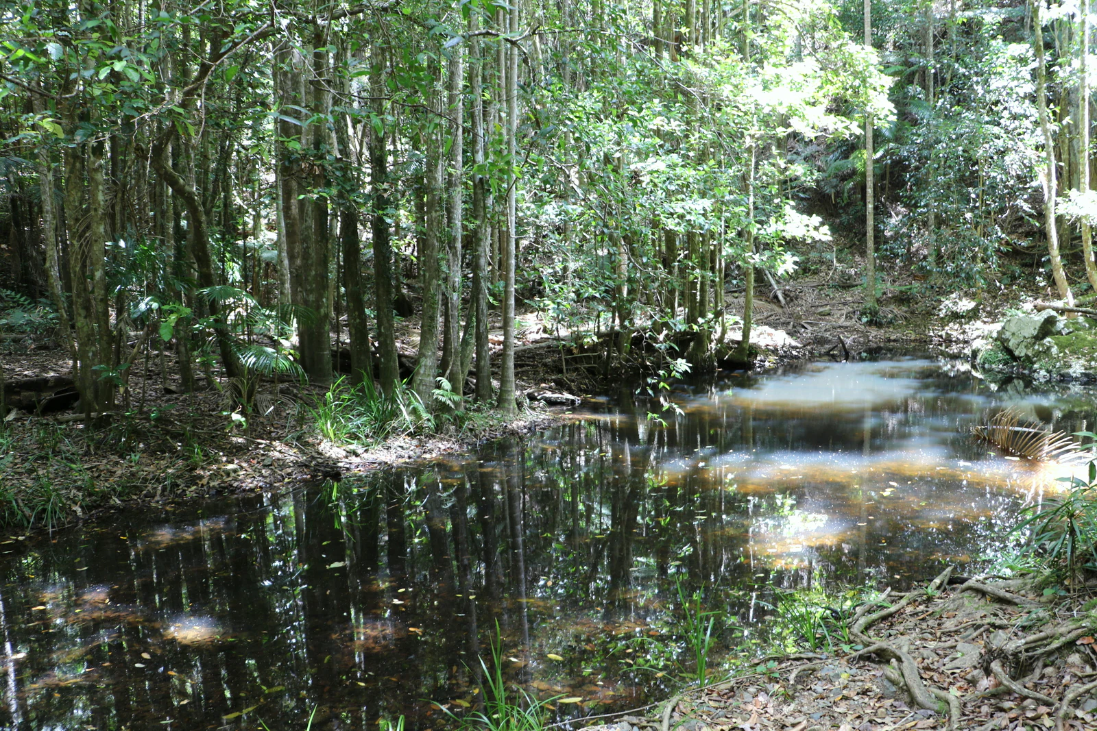
A small creek winds through dense subtropical rainforest, reflecting the surrounding trees in its calm, dark water.
Woolgoolga Creek flowing through the subtropical rainforest of Sherwood Nature Reserve.

Sherwood Nature Reserve history and protected-area timeline

The land that now forms Sherwood Nature Reserve has a layered history of use and protection. The area was originally part of Wedding Bells State Forest, and the rainforest sections along Woolgoolga Creek were heavily logged in the early 1900s, when a tramway connected the forest to the town of Woolgoolga for timber transport. Rainforest logging ceased in 1917, marking an early transition away from exploitation of the most sensitive forest types.

The former Woolgoolga Creek Flora Reserve was dedicated in 1917, recognizing the ecological value of the remaining rainforest along the creek. This was later reinforced when the area was formally gazetted as a flora reserve in 1971, strengthening its protected status. Hardwood logging continued in surrounding parts of the forest until the 1940s, after which the broader landscape began to shift toward different land uses.

In the eastern sections of what is now Sherwood, land was cleared during the 1960s for hardwood plantation establishment, with flooded gum as the dominant species and bunya pine used in trial plantings. Earlier in the century, banana plantations had occupied parts of the same land, operating from the early 1900s until the late 1960s, when they were replaced with forestry plantations. The eventual consolidation of these lands into Sherwood Nature Reserve brought together a complex mosaic of old-growth rainforest, regenerating forest, and plantation history under a single conservation framework.

Sherwood Nature Reserve landscape and geographic character

The landscape of Sherwood Nature Reserve is shaped by the catchments and ridgelines of the Woolgoolga Creek system, in a setting that transitions from coastal lowlands to forested hills. Sheltered gullies and creek corridors maintain the cool, moist microclimates that allow subtropical rainforest to thrive, while surrounding ridges support drier forest types. This combination of topography and microclimate is central to the reserve's ecological character.

Woolgoolga Creek is a defining landscape feature, with rainforest pressing directly against its banks in many sections. The watercourse, the surrounding slopes, and the sheltered valleys together create a layered environment of canopy, understory, and creek-side vegetation. The elevation is relatively low compared to inland reserves, but local relief and aspect strongly influence where rainforest can persist.

Sherwood Nature Reserve ecosystems, habitats, and plant life

Sherwood's ecological identity is built around subtropical rainforest, a vegetation type that has been dramatically reduced across coastal New South Wales since the 1800s. Within the reserve, particularly along Woolgoolga Creek, the rainforest contains a notable diversity of tree species, combining tall emergent species with a layered understory of palms, figs, and myrtles. The mix of mature and regenerating rainforest creates structural variety across the reserve.

Beyond the rainforest zones, the reserve includes areas of regrowth forest on former logging land, patches of plantation origin, and transitional vegetation where cleared land is gradually being reclaimed by native species. This mosaic supports different successional stages and habitat conditions, increasing the overall ecological complexity of the reserve. The combination of rainforest, regrowth, and plantation mosaics makes Sherwood ecologically richer than its individual vegetation types might suggest.

Sherwood Nature Reserve wildlife and species highlights

The reserve provides habitat for a wide range of native fauna typical of north coast New South Wales, including mammals, birds, frogs, reptiles, and invertebrates. Documented species include the brush-tailed rock wallaby, the powerful owl, leaf-tailed geckos, the giant barred frog, and the long-nosed potoroo, illustrating the breadth of habitat types the reserve supports, from rocky outcrops and rainforest gullies to wet forest floors.

A standout wildlife feature of the reserve is the Woolgoolga Creek rainforest population of the rare mottled tree snail, a species of significant conservation interest that depends on intact subtropical rainforest habitat. The reserve's combination of older forest and moist refugia allows sensitive species to persist where they might otherwise disappear.

Sherwood Nature Reserve conservation status and protection priorities

Sherwood Nature Reserve plays an important role in protecting what remains of subtropical rainforest in the Woolgoolga area, a vegetation type that has been reduced to small remnants across much of coastal New South Wales. By safeguarding rainforest along Woolgoolga Creek and buffering it with surrounding forested land, the reserve helps maintain habitat for rainforest-dependent species and supports broader landscape connectivity between forested hills and the coast.

The reserve's conservation value is enhanced by its history, which includes formal protection progressively strengthened through the 20th century. The protection of former plantation land alongside older rainforest means the reserve also contributes to long-term forest recovery, allowing regrowth and succession to rebuild structural complexity on lands that were once cleared or planted. In this sense, Sherwood is both a refuge for existing biodiversity and a canvas for ongoing forest recovery.

Top sights and standout views in Sherwood Nature Reserve

Sherwood Nature Reserve's standout qualities include its high-diversity subtropical rainforest along Woolgoolga Creek, its rare habitat for the mottled tree snail, and its unusually layered land-use history spanning early logging, banana cultivation, plantation forestry, and modern nature conservation. The reserve is notable for bringing mature rainforest, regenerating forest, and former plantation land under a single protection framework, creating an ecologically varied protected landscape.

Best time to visit Sherwood Nature Reserve

Sherwood Nature Reserve is a wet, forested environment where conditions vary strongly with the seasons. Cooler and drier months generally offer more comfortable walking conditions and lower humidity, while the warmer, wetter season brings lusher rainforest foliage, fuller creek flows, and active amphibian and invertebrate life. Bird and frog activity tends to peak during warmer, moister periods, making the reserve particularly rewarding for wildlife watchers at those times. Mist and damp creek-side conditions are characteristic features of the rainforest experience, regardless of season.

Monthly climate preview

Long-term representative monthly temperature and precipitation cycles

Sherwood Nature Reserve Climate Normals and Annual Weather Patterns

Sherwood Nature Reserve experiences measured annual temperature variations and monthly precipitation rhythms based on historical representative coordinates. Examining the complete twelve-month climate profile provides detailed historical statistics for sustained environmental research.
Annual mean20 °C
15 °C24 °C
Jan24°
Feb24°
Mar22°
Apr20°
May18°
Jun16°
Jul15°
Aug15°
Sep18°
Oct20°
Nov21°
Dec23°
Warmest month
January

24 °C

Coolest month
July

14.7 °C

Wettest month
February

6.5 mm/day

Driest month
September

1.5 mm/day

Park location guide

Geography guide, regional context, and park location map for Sherwood Nature Reserve

Sherwood Nature Reserve park geography, regions, and map view in Australia

Understand where Sherwood Nature Reserve sits in Australia through a broader geographic reading of the surrounding landscape, nearby location context, and its mapped position within the national park landscape.

How Sherwood Nature Reserve fits into Australia

Australia is a constitutional monarchy and federal parliamentary democracy comprising six states and ten territories. With a population of nearly 28 million, it is one of the world's most urbanised countries, with most people concentrated on the eastern seaboard. The country has a high Human Development Index and is known for its cultural diversity, ancient Aboriginal heritage, and unique wildlife.

Wider geography shaping Sherwood Nature Reserve in Australia

Australia occupies the entire Australian continent, the island of Tasmania, and numerous smaller islands. It is the world's flattest and driest inhabited continent, featuring vast deserts in the interior (the Outback), tropical rainforests along the eastern coast, and a coastline bordering the Indian and Pacific Oceans.

Map view of Sherwood Nature Reserve

Use this park location map to pinpoint Sherwood Nature Reserve in Australia, understand its exact geographic position, and read its mapped placement within the surrounding landscape more clearly.

Pigeon | © OpenStreetMap contributors

Location context for Sherwood Nature Reserve

New South Wales

Explore photographic records of subtropical rainforest habitats and creek corridors within the protected landscape.

Sherwood Nature Reserve Photos and Landscapes: Visualizing Coastal Rainforest Scenery

Visual documentation captures the complex terrain and dense canopy cover found along the Woolgoolga Creek catchments. Detailed imagery reveals the varied vegetation structure of mature rainforest stands, regenerating timber zones, and sheltered valley environments.

A small creek winds through dense subtropical rainforest, reflecting the surrounding trees in its calm, dark water.

Park atlas

Compare adjacent coastal reserves and regional forest habitats across New South Wales

Explore Parks Near Sherwood Nature Reserve and Surrounding Protected Landscapes

Browsing other protected areas near Sherwood Nature Reserve reveals a diverse network of coastal forests, creek corridors, and regenerating rainforest remnants. Examining adjacent reserves provides essential geographic context for understanding regional biodiversity and forest recovery patterns along the coast.
National parkNew South Wales
About 14 km away#1 closest

North

Yuraygir National Park: New South Wales Protected Area Geography and Landscape Atlas

Discover mapped boundaries and natural terrain context.

Delve into the detailed geography of Yuraygir National Park, a protected natural landscape in New South Wales, Australia. This entry provides core atlas-relevant information, focusing on its mapped protected area boundaries and the intrinsic geographic character of the region, essential for understanding its place in conservation landscapes.

Area
313.71 km²
Established
1980
IUCN
II
Climate
Temperate
National parkNew South Wales
About 14 km away#2 closest

Southwest

Ulidarra National Park: New South Wales Strict Nature Reserve and Wildlife Sanctuary

Explore its elevation range, mapped forest ecosystems, and protected habitats.

Ulidarra National Park represents a small yet ecologically vital protected area within New South Wales, Australia. Classified as a strict nature reserve, it preserves significant old-growth eucalyptus forests and intact rainforests across a notable elevation gradient. The park is recognized for providing critical habitat for species like koalas and various native birds, making it a key site for understanding regional wildlife diversity and protected landscape conservation through detailed mapping and geographic context.

Area
6.8 km²
Established
1999
IUCN
Ia
Relief
Mixed relief
A horizontal watercolor illustration depicting rolling green hills, distant mountains in muted tones, and grassy foreground vegetation.
Nature reserveNew South Wales
About 15 km away#3 closest

Southwest

Coramba Nature Reserve: Protected Lowland Rainforest Geography in New South Wales

A vital forest fragment in the Clarence River valley

Coramba Nature Reserve stands as a significant ecological sanctuary in coastal New South Wales. This protected area preserves a rare lowland sub-tropical rainforest, serving as an important reference site for botanical study and forest conservation within the broader geography of the Clarence River valley region.

Area
0.094 km²
Established
1982
IUCN
IV
Relief
Lowland
A soft watercolor illustration showing a peaceful coastal landscape with rolling green hills, calm water, and distant island silhouettes under a pale pink sky.
Marine protected areaNew South Wales
About 15 km away#4 closest

Southeast

Solitary Islands Marine Park: Mapped Boundaries and Coastal Marine Geography

Key marine protected area in New South Wales

Solitary Islands Marine Park protects a 75 kilometre stretch of the Australian coast, defined by offshore islands, fringing reefs, and vital estuarine environments. This atlas entry provides geographic context for the park's transition between tropical and temperate zones, highlighting its role as a regional anchor for marine conservation and ecological research.

Area
720 km²
Established
1998
Relief
Lowland
Climate
Subtropical
Watercolor illustration of a mountainous landscape with trees and rolling hills
National parkNew South Wales
About 21 km away#5 closest

Southwest

Bindarri National Park: National Park Protected Area Atlas and Geographic Setting

Explore mapped boundaries and New South Wales regional context.

Bindarri National Park is a designated national park within New South Wales, Australia, serving as a vital point for understanding protected landscapes. This entry focuses on its geographic identity, mapped boundaries, and its contribution to the regional atlas of conservation areas. Users can gain insight into the specific natural terrain and spatial distribution of this protected land, facilitating a deeper appreciation of its geographical significance within Australia.

Area
55.95 km²
Established
1999
IUCN
II
Scope
Terrestrial
National parkNew South Wales
About 27 km away#6 closest

South

Bongil Bongil National Park: Exploring New South Wales' Protected Landscape Identity

Mapped boundaries and regional geography of a national park.

This entry for Bongil Bongil National Park provides an atlas-focused view of its protected landscape within New South Wales. Understand the park's geographic context, its designation as a national park, and how its mapped boundaries contribute to the broader regional geography. It serves as a distinct point of entry for exploring the specific conservation lands and natural terrain that define this Australian park entity for detailed atlas-based study.

Area
42.33 km²
Established
1995
IUCN
II
Relief
Lowland
National parkNew South Wales
About 31 km away#7 closest

Southwest

Cascade National Park: National Park in New South Wales with Mapped Protected Boundaries

Explore the unique geography and landscape context of this protected area.

Delve into Cascade National Park, a protected national park located in New South Wales, Australia. This entity is crucial for understanding the mapped geographic extent and specific landscape characteristics of one of Australia's protected natural areas. Its inclusion within the atlas provides a grounded point for examining regional conservation lands and their spatial distribution.

Area
36 km²
Established
1999
IUCN
II
Climate
Temperate
National parkNew South Wales
About 31 km away#8 closest

Southwest

Dorrigo National Park: National Park Geography and Mapped Protected Landscape

Explore the regional context and unique geographic boundaries of this New South Wales park.

Dorrigo National Park serves as a significant protected area within the broader geographic tapestry of New South Wales. This entry offers detailed insights into its mapped boundaries and landscape characteristics, positioning it within Australia's network of national parks. Users seeking structured geographic information and an atlas-style understanding of protected lands will find valuable context here, focusing on the park's inherent natural features and regional setting.

Area
119 km²
Established
1967
IUCN
II
Relief
Highland

Common questions about visiting, size, designation, and location context for Sherwood Nature Reserve

Sherwood Nature Reserve FAQs for park facts, access, geography, and protected area context

Find quick answers about Sherwood Nature Reserve, including protected-area facts, park geography, trail and visitor context, and how the park fits into its surrounding country and regional landscape.
MoriAtlas Explorer

Continue Your Protected Areas Search Across the Global Atlas

Deepen your exploration by continuing the structured search for national parks and protected areas worldwide. Utilize the comprehensive filtering capabilities to compare different conservation landscapes and refine your understanding of global park geography. Discover more about the distribution and characteristics of protected natural areas.

Global natural geography