Mori Atlas logo
National parkSibiloi National Park

Discover the geographic extent and protected area identity of Sibiloi National Park.

Sibiloi National Park: Mapped Boundaries and Protected Landscape Geography

Sibiloi National Park represents a significant protected natural area situated within the expansive geography of Rift Valley Province, Kenya. This canonical entry serves as a dedicated point for understanding its mapped boundaries and its role as a protected landscape. Explore the fundamental geographic context that defines Sibiloi National Park, offering a foundational view for atlas-based discovery and appreciation of its protected terrain.

UNESCO World Heritage SiteFossil SitesLake EcosystemsSemi-Desert LandscapeVolcanic TerrainArchaeological Heritage

Sibiloi National Park

National park

Park overview

Structured park overview, official facts, and landscape profile for Sibiloi National Park

Sibiloi National Park park facts, protected area profile, and essential visitor context
Review the core facts for Sibiloi National Park, including designation, size, terrain, visitor scale, habitats, and operating context in one park-focused overview.

About Sibiloi National Park

Sibiloi National Park represents one of Kenya's most distinctive protected areas, combining exceptional archaeological significance with a rugged, semi-desert landscape that contrasts sharply with the better-known savanna parks of southern and western Kenya. The park occupies a strategic position along the northeastern shore of Lake Turkana, a massive inland sea surrounded by volcanic terrain and arid plains that together form one of the most visually striking environments in East Africa. The establishment of the park in 1973 reflected the Kenyan government's recognition that the area contained irreplaceable scientific and cultural resources, particularly the fossil beds around Koobi Fora that had begun yielding hominin specimens of extraordinary importance during the preceding decade. The park's management under the Kenya Wildlife Service ensures continued protection of both the archaeological sites and the diverse wildlife populations that inhabit the lake margin and adjacent plains. Visitors to Sibiloi encounter a landscape that feels ancient and otherworldly, where volcanic peaks rise from semi-arid terrain and the vast expanse of Lake Turkana creates a constantly shifting play of light across the water. The park's research facilities at Koobi Fora include a museum displaying fossil specimens, offering visitors insight into the discoveries that have made the area famous.

Quick facts and research context for Sibiloi National Park

Sibiloi National Park is located in Kenya's Rift Valley Province along the northeastern shore of Lake Turkana, the world's largest desert lake. The protected area spans roughly 1,570 square kilometers of semi-arid bushland, volcanic terrain, and lake-margin ecosystems. It was established in 1973 and is managed by the Kenya Wildlife Service. The park forms part of the Lake Turkana National Parks World Heritage Site, inscribed in 1997 and expanded in 2001. The area is internationally renowned for the Koobi Fora archaeological locality, which has yielded fossil specimens representing multiple phases of human evolution.

Park context

Deeper park guide and search-rich context for Sibiloi National Park

Sibiloi National Park history, landscape, wildlife, and travel context
Explore Sibiloi National Park through its history, landscape character, ecosystems, wildlife, conservation priorities, cultural context, and seasonal travel timing in a structured park guide built for atlas discovery and search intent.

Why Sibiloi National Park stands out

Sibiloi National Park is best known for its extraordinary paleontological significance and its role in advancing understanding of human evolution. The Koobi Fora archaeological sites, accessible through guided tours from the park's research facilities, have produced fossil remains of Australopithecus and early Homo species that have contributed more to the scientific understanding of human origins than any other site in Africa. The park also preserves volcanic formations including Mount Sibiloi, where the remains of a petrified forest can be observed. The stark, semi-desert landscape along Lake Turkana creates a powerful sense of place, connecting visitors to the ancient geological and archaeological processes that have shaped both the land and our species.

Sibiloi National Park history and protected-area timeline

The formal establishment of Sibiloi National Park in 1973 marked the culmination of growing recognition within the Kenyan scientific community and government that the Lake Turkana shoreline contained archaeological resources of global significance. Fossil discoveries in the Koobi Fora region had begun in the 1960s and 1970s, revealing a remarkable concentration of hominin remains that would eventually establish the area as one of the most productive paleoanthropological localities in the world. The park was named for Mount Sibiloi, the prominent volcanic formation that forms a visual anchor along the southern boundary of the protected area and is clearly visible from Alia Bay. The Kenya Wildlife Service established park headquarters at Sibiloi, developing basic visitor facilities including camping accommodations and establishing the Koobi Fora Museum to house and display specimens recovered from the surrounding archaeological sites. The park's international recognition was solidified when it became part of the Lake Turkana National Parks World Heritage Site in 1997, with an extension added in 2001, acknowledging both the natural and cultural significance of the broader lake ecosystem.

Sibiloi National Park landscape and geographic character

The landscape of Sibiloi National Park is defined by the intersection of Lake Turkana with a terrain of volcanic origin and semi-desert character. The park's eastern boundary follows the shoreline of Lake Turkana, a massive endorheic lake covering approximately 6,400 square kilometers and known as the world's largest desert lake. Inland from the lake margin, the terrain consists largely of open plains dotted with volcanic rocks and occasional ridges, with Mount Sibiloi rising prominently in the southern sector of the park. The mountain and surrounding volcanic formations create an distinctive backdrop, while the petrified forest remains on the slopes of Mount Sibiloi provide tangible evidence of the area's geological history. The landscape lacks the extensive woodland or dense vegetation found in many other Kenyan protected areas, instead presenting a stark beauty characterized by open horizons, volcanic silhouettes, and the ever-present blue expanse of the lake.

Sibiloi National Park ecosystems, habitats, and plant life

The natural environment of Sibiloi National Park reflects the harsh but ecologically significant conditions of the Lake Turkana basin. The semi-desert habitat supports specialized plant and animal communities adapted to the arid climate, with vegetation typically consisting of scattered shrubs, grass tufts, and occasional acacia trees in protected valleys. The lake itself supports significant populations of Nile crocodiles and various fish species, creating a rich aquatic ecosystem that attracts diverse birdlife to the shoreline and surrounding wetlands. The broader park ecosystem includes species adapted to arid conditions, with wildlife typically concentrated near the lake margin where vegetation is more abundant and permanent water is available. This combination of terrestrial and aquatic habitats creates ecological diversity despite the challenging climate, supporting populations of mammals, reptiles, and birds that have evolved to thrive in this distinctive corner of Kenya.

Sibiloi National Park wildlife and species highlights

The wildlife of Sibiloi National Park reflects the park's position in a semi-desert environment where animal populations are concentrated primarily around the lake margin and available water sources. Lake Turkana supports substantial populations of Nile crocodiles and various fish species, making it a significant aquatic habitat within the region. The shoreline and adjacent wetlands attract diverse birdlife, including numerous waterfowl and wading species that utilize the lake as a resting and feeding area during migration. On the open plains away from the water, wildlife is more sparsely distributed but includes typical arid-country species adapted to the semi-desert conditions. The park provides protection for these wildlife populations within the broader context of the Lake Turkana ecosystem, ensuring that the archaeological and natural values of the area are maintained together.

Sibiloi National Park conservation status and protection priorities

Sibiloi National Park holds significance both for its cultural heritage and its role in protecting the Lake Turkana ecosystem. The UNESCO World Heritage designation acknowledges the exceptional universal value of the area as both a natural landscape and a repository of irreplaceable evidence regarding human evolution. The park's protection of the Koobi Fora fossil sites ensures that these irreplaceable scientific resources remain preserved for continued research and education. Beyond the archaeological significance, the protected area contributes to conservation of the Lake Turkana basin's biodiversity, preserving the semi-desert ecosystem and the species that depend on this distinctive environment. Management by the Kenya Wildlife Service integrates protection of both the cultural and natural resources that make Sibiloi exceptional.

Sibiloi National Park cultural meaning and human context

The cultural context of Sibiloi National Park extends beyond its archaeological significance to include the broader relationship between the Lake Turkana region and the human communities who have inhabited this corner of Kenya over generations. The Turkana people, Kenya's largest pastoralist community, maintain traditional connections to the lands surrounding the lake, and their presence shapes the cultural landscape of the region. While the park itself is managed as a protected area, the surrounding territory remains inhabited by communities whose livelihoods are tied to the land and the lake. The Koobi Fora research program has also created an ongoing cultural layer, with the research center and museum establishing a tradition of scientific engagement with the landscape that complements the deeper historical connections.

Top sights and standout views in Sibiloi National Park

Sibiloi National Park offers visitors the opportunity to explore one of the most significant archaeological landscapes in the world while experiencing the stark beauty of the Lake Turkana shoreline. The Koobi Fora Museum provides interpretive context for the fossil discoveries that have shaped understanding of human evolution, while guided tours offer access to the research area and fossil sites. The view of Mount Sibiloi from Alia Bay ranks among the most memorable vistas in any Kenyan park, with the volcanic peak rising dramatically from the semi-desert terrain. The petrified forest remains on the mountain slopes represent a tangible connection to the region's geological history. Wildlife viewing along the lake margin reveals crocodiles, diverse birdlife, and the opportunity to experience an ecosystem quite different from Kenya's more famous savanna parks.

Best time to visit Sibiloi National Park

The best time to visit Sibiloi National Park corresponds to the dry seasons when wildlife viewing conditions are most favorable and visitor access is most comfortable. The park's semi-desert environment means that conditions can be extremely hot throughout the year, with temperatures consistently elevated even during the cooler dry season months. The landscape retains a stark beauty in any season, but the drier periods typically offer more comfortable conditions for exploring the park's archaeological sites and scenic viewpoints. Visitors should be prepared for remote conditions with limited facilities, as the park remains one of Kenya's less developed protected areas despite its World Heritage status.

Park location guide

Geography guide, regional context, and park location map for Sibiloi National Park

Sibiloi National Park park geography, regions, and map view in Kenya
Understand where Sibiloi National Park sits in Kenya through a broader geographic reading of the surrounding landscape, nearby location context, and its mapped position within the national park landscape.

How Sibiloi National Park fits into Kenya

Kenya is a presidential republic in East Africa and the seventh-most populous country on the continent. Its capital is Nairobi, and it borders five countries and the Indian Ocean. The country features significant geographic diversity including Mount Kenya, the Rift Valley, and coastal regions.

Wider geography shaping Sibiloi National Park in Kenya

Kenya is located in East Africa, bordering South Sudan to the northwest, Ethiopia to the north, Somalia to the east, Tanzania to the southwest, and Uganda and Lake Victoria to the west. The southeastern border meets the Indian Ocean. The geography includes the Rift Valley highlands with Mount Kenya, coastal plains, and northern arid regions.

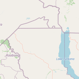
Map view of Sibiloi National Park

Use this park location map to pinpoint Sibiloi National Park in Kenya, understand its exact geographic position, and read its mapped placement within the surrounding landscape more clearly.

Pigeon | © OpenStreetMap contributors

Location context for Sibiloi National Park

Rift Valley Province
Park atlas

Browse Kenya's regional park geography, trace the spread of protected areas, and compare diverse landscapes beyond Sibiloi National Park.

Explore Other National Parks and Protected Areas Near Sibiloi National Park
After exploring Sibiloi National Park's unique fossil sites and semi-desert volcanic landscapes, continue your discovery by mapping other national parks and protected areas across Kenya's Rift Valley region. Compare diverse conservation landscapes, from additional UNESCO World Heritage Sites to other vital ecosystems, providing essential geographic context for East Africa's protected areas.
National parkSouth Ethiopia Regional State

Mago National Park: Protected Savanna and Riverine Ecosystems in South Ethiopia

Discover the unique landscapes and wildlife habitats mapped within this national park.

Mago National Park stands as a critical protected landscape within the South Ethiopia Regional State, characterized by its significant riverine forests, acacia savanna, and wetland environments along the Mago and Omo rivers. This national park is integral for understanding the distribution of wildlife and the geographic context of Ethiopia's natural heritage. Its mapped terrain offers insights into a landscape that supports both diverse ecosystems and unique cultural traditions, making it a vital component of the country's conservation network.

Area
2,220 km²
Established
1979
IUCN
II
Relief
Mixed relief
National parkEthiopia

Omo National Park: Ethiopia's Remote Protected Landscape with Rich Wildlife Spectacles

Mapped boundaries, savannah plains, and Maji Mountains terrain.

Omo National Park is a remote protected area in Ethiopia renowned for its expansive savannah, riverine woodlands, and remarkable wildlife concentrations. Covering over 4,000 square kilometers, this national park presents a landscape of sweeping plains, the vital Omo River corridor, and the dramatic Maji Mountains. The park's protected status safeguards exceptional populations of large mammals, offering a glimpse into an untamed African wilderness. Explore the mapped geography and the unique ecological zones that contribute to its significant conservation value.

Area
4,068 km²
Established
1980
IUCN
II
Relief
Mixed relief
National parkOromia Region

Borana National Park National Park: Geographic Context and Protected Landscape Atlas

Explore the mapped boundaries and regional geography.

Gain a detailed understanding of Borana National Park, identified as a national park within the Oromia Region of Ethiopia. This entry focuses on its geographic context, providing mapped information crucial for understanding its protected landscape identity. Examine how Borana National Park fits into the broader atlas of conservation areas, offering a precise view of its unique terrain and regional significance without operational details.

Area
45,366 km²
Established
1986
IUCN
II
Relief
Mountain
National parkMarsabit County

Marsabit National Park: Protected Area Identity and Geographic Setting in Kenya

Explore mapped landscape and regional park geography.

Marsabit National Park represents a critical protected area within the geographic expanse of Marsabit County, Kenya. This entry provides essential context for understanding the park's specific identity as a national park, its delineated boundaries, and its place within the natural landscape. For those interested in atlas-style exploration, this park detail offers foundational geographic information and insights into its protected status, anchoring its role in a broader discovery of Kenya's natural heritage.

Area
1,554 km²
Established
1949
Relief
Mountain
Climate
Subtropical
National parkSouth Ethiopia Regional State

Nechisar National Park: Protected Natural Landscape in South Ethiopia Regional State

Explore the mapped geography and protected area context of this Ethiopian park.

Nechisar National Park is designated as a national park, serving as a critical protected natural area within the South Ethiopia Regional State. This MoriAtlas entry provides detailed geographic context, focusing on the park's mapped boundaries and its place within the regional landscape. Users can explore the park's identity as a protected territory, offering a foundation for understanding Ethiopia's natural protected areas through a geographic lens.

Area
1,030 km²
Established
1974
IUCN
II
Relief
Mixed relief
National parkEthiopia

Maze National Park: Ethiopia's Essential National Park for Swayne's Hartebeest and Geothermal Wonders

Discover mapped savanna ecosystems and unique montane geography within this protected Ethiopian landscape.

Maze National Park represents a significant protected area within Ethiopia, vital for the conservation of the endangered Swayne's hartebeest. Its diverse terrain includes savanna grasslands and unique geothermal features such as active geysers, all set against a distinctive montane backdrop. This national park offers a deep dive into Ethiopia's natural heritage, providing a clear geographic identity and valuable context for landscape exploration.

Area
210 km²
Established
2005
IUCN
II
Relief
Mixed relief
National parkSouth West Ethiopia Peoples' Region

Chebera Churchura National Park: Ethiopia's National Park Protected Landscape Explorer

Mapping the protected area and regional geography of Chebera Churchura.

Chebera Churchura National Park is a key protected landscape in the South West Ethiopia Peoples' Region, designated as a national park. This page provides detailed geographic context and atlas-level information about the park's boundaries and its place within the regional terrain. Engage with the structured data that defines Chebera Churchura National Park's identity as a significant natural area for map-based discovery.

Area
1,250 km²
Established
2006
IUCN
II
Climate
Tropical
National parkTrans-Nzoia County

Saiwa Swamp National Park National Park: Mapped Protected Area in Trans-Nzoia County

Explore the geographic context and protected landscape features.

Saiwa Swamp National Park serves as a vital national park within Trans-Nzoia County, Kenya, offering a unique perspective on protected lands. This page details its mapped geography and landscape characteristics, providing essential context for atlas-based exploration of its protected boundaries and regional setting. Understand the specific features that define this important conservation area.

Area
3 km²
Established
1974
IUCN
II
Relief
Lowland

Common questions about visiting, size, designation, and location context for Sibiloi National Park

Sibiloi National Park FAQs for park facts, access, geography, and protected area context
Find quick answers about Sibiloi National Park, including protected-area facts, park geography, trail and visitor context, and how the park fits into its surrounding country and regional landscape.
MoriAtlas Explorer

Continue Your Protected Areas Search Across the Global Atlas

Deepen your exploration by continuing the structured search for national parks and protected areas worldwide. Utilize the comprehensive filtering capabilities to compare different conservation landscapes and refine your understanding of global park geography. Discover more about the distribution and characteristics of protected natural areas.

Global natural geography