Mori Atlas logo
Protected areaSierra de los Agustinos

Tracing the volcanic ridges and oak forest ecosystems of this central Mexico highland refuge

Sierra de los Agustinos: A Mapped Protected Area within the Volcanic Landscape of Guanajuato

Rising abruptly from the Bajio plains, Sierra de los Agustinos stands as a critical protected area defined by its fractured volcanic geology and layered vegetation. This range functions as a vital link in the Trans-Mexican Volcanic Belt, supporting everything from tropical deciduous forests to oak-dominated slopes. The geography here is defined by deep hydrological connections, including the essential Agustinos Aquifer, which sustains surrounding lowlands through natural groundwater recharge processes.

volcanic mountainsBajío regioncentral MexicoGuanajuatoprotected natural areasustainable use reserve

Sierra de los Agustinos

Protected area

Park overview

Structured park overview, official facts, and landscape profile for Sierra de los Agustinos

Sierra de los Agustinos park facts, protected area profile, and essential visitor context

Review the core facts for Sierra de los Agustinos, including designation, size, terrain, visitor scale, habitats, and operating context in one park-focused overview.

About Sierra de los Agustinos

Sierra de los Agustinos occupies a strategic position at the meeting point between the Bajío plains and the volcanic highlands of central Mexico. The range belongs to the state of Guanajuato, where it rises sharply from otherwise flat terrain, forming a visually prominent landmark visible from surrounding towns such as Acámbaro. Its setting within the Lerma River basin ties it hydrologically to one of Mexico's most important inland river systems, while its geological makeup reflects the long volcanic history associated with the Trans-Mexican Volcanic Belt.

Beyond its physical setting, the Sierra is significant for the ecological gradients it preserves across relatively short distances. Lower slopes support tropical deciduous forest adapted to seasonal dry conditions, while higher elevations transition into oak-dominated woodland more typical of the volcanic belt's uplands. These forest types create habitat diversity that supports a wide community of mammals, birds, reptiles, and pollinators. The range's protected natural area designation reflects a recognition that this gradient deserves formal conservation attention, both for its biodiversity and for the environmental services it provides.

The Sierra also carries strong practical importance for surrounding communities. Its porous, fractured rocks allow rainwater to percolate into the Agustinos Aquifer, recharging groundwater that supports agriculture and settlement in the adjacent lowlands. Mineral deposits including opal, perlite, kaolin, and silica sand add an additional dimension to its geological identity. Recreational use, traditional firewood harvesting, and watershed services all combine to make the Sierra a working landscape as much as a protected one, embodying the principles of a sustainable use reserve.

Quick facts and research context for Sierra de los Agustinos

Sierra de los Agustinos is a volcanic mountain range in central Mexico, lying within the state of Guanajuato and shared among the municipalities of Acámbaro, Jerécuaro, and Tarimoro. The range rises from the Bajío, the high agricultural plain of central Mexico, and belongs to the northern reaches of the Trans-Mexican Volcanic Belt. It sits within the Lerma River basin and contributes to regional water security through its fractured volcanic rocks and the Agustinos Aquifer. Designated a protected natural area in 2002, the range covers roughly 191 square kilometers and combines tropical deciduous forest at low elevation with oak forest higher up. It forms part of the broader monarch butterfly migration corridor that connects breeding grounds in North America with the overwintering sanctuaries in Michoacán and the State of Mexico.

Protection and recognition

Documented terrestrial conservation scope and official establishment timeline

Sierra de los Agustinos Protection Status and Official Designation History

Sierra de los Agustinos maintains a documented terrestrial protection status established in the year 2002. Structured conservation records outline the official management scope and designation history for this protected area.

Protection details

Protection scope
Terrestrial
Designated year
2002
Park context

Deeper park guide and search-rich context for Sierra de los Agustinos

Sierra de los Agustinos history, landscape, wildlife, and travel context

Explore Sierra de los Agustinos through its history, landscape character, ecosystems, wildlife, conservation priorities, cultural context, and seasonal travel timing in a structured park guide built for atlas discovery and search intent.

Why Sierra de los Agustinos stands out

Sierra de los Agustinos is best known as a compact volcanic refuge where tropical deciduous forest meets oak forest within central Mexico's Bajío region. Its defining character lies in the way fractured volcanic rock, layered vegetation, and aquifer recharge combine to support both biodiversity and downstream human communities. The range is also notable for hosting one of the northernmost links in the monarch butterfly migration route, connecting it ecologically to the world-famous overwintering sanctuaries further south. The combination of protected-area status, mineral diversity, and groundwater importance gives the Sierra an outsized relevance relative to its size.
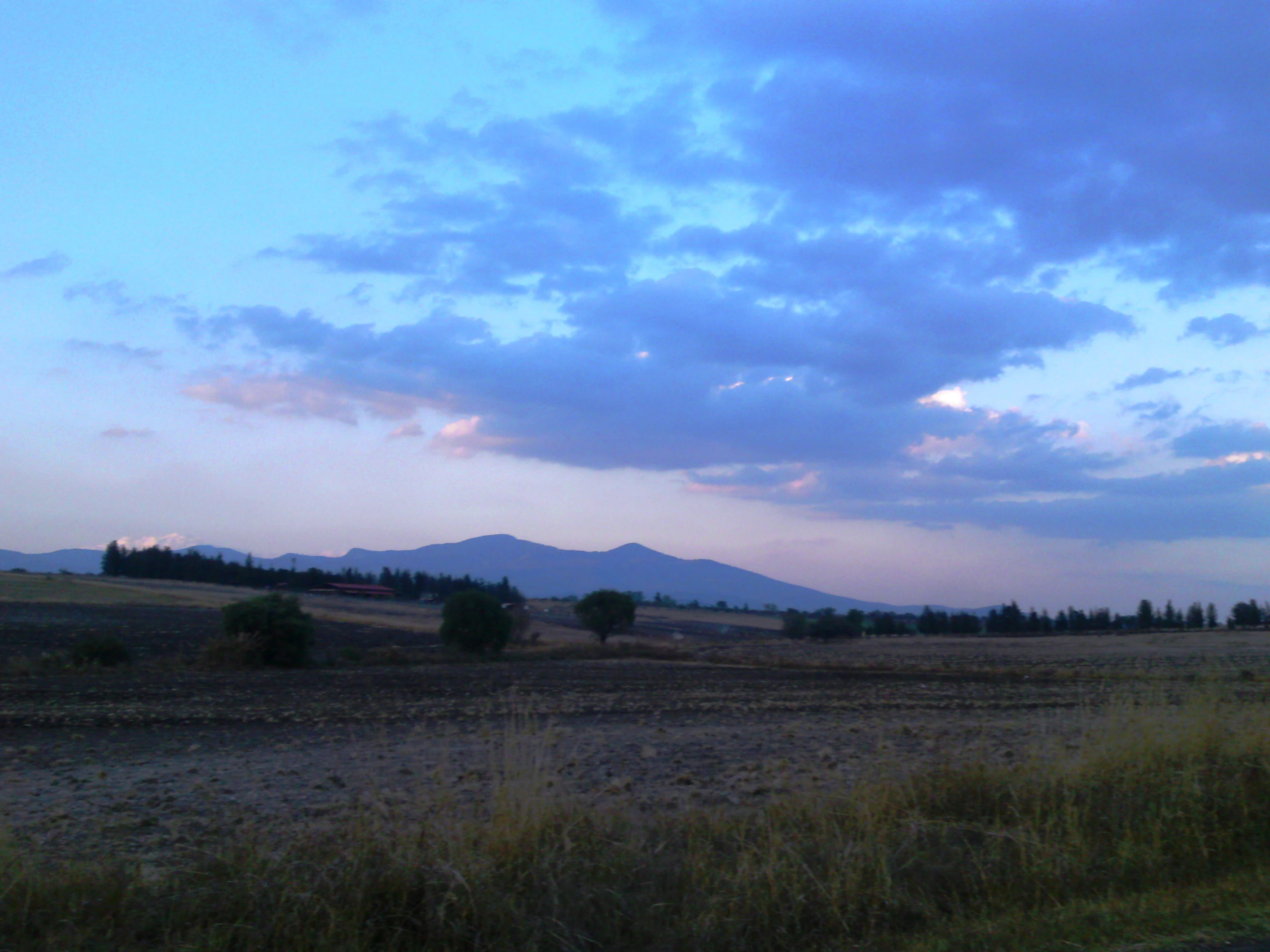
A landscape view showing flat fields with scattered trees in the foreground and a mountain range silhouetted against a blue and pink cloudy sky at dusk
A view overlooking the Agustinos hills at dusk with scattered trees and fields in the foreground

Sierra de los Agustinos history and protected-area timeline

Sierra de los Agustinos was officially designated as a protected natural area in the early 2000s, with its formal recognition as a sustainable use area recorded in 2002. The designation covered an area of roughly 191.65 square kilometers and aimed to reconcile the conservation of the range's distinctive flora, fauna, and aquifer function with the ongoing human activities that depend on it, including traditional resource use and recreation.

Beyond the formal conservation milestone, the range has long been part of the regional landscape experienced by communities in Acámbaro, Jerécuaro, and Tarimoro. Its springs, forests, and mineral resources have shaped local livelihoods over generations, while its role in supporting the monarch butterfly migration connects it to a much older ecological story that predates modern protection frameworks.

Sierra de los Agustinos landscape and geographic character

The Sierra de los Agustinos is a volcanic mountain range that rises abruptly from the Bajío, a broad high plain that defines much of central Mexico. Its peaks and ridges create a notable topographic contrast with the surrounding agricultural lowlands, giving the range a strong visual presence on the regional skyline. The terrain is shaped by past volcanic activity, with porous and highly fractured rocks that influence how water moves through and beyond the range.

Within the Trans-Mexican Volcanic Belt, the Agustinos represent a northern extension, with the main mass of the belt continuing further to the south and southeast. The Sierra is framed by the Lerma River basin to the south and west, and it contributes substantially to regional hydrology through the Agustinos Aquifer. Mineral diversity adds another layer to the landscape's character, with deposits of opal, perlite, kaolin, and silica sand embedded in the volcanic geology. The combination of elevation change, volcanic form, and hydrological importance makes the landscape both visually striking and ecologically functional.

Sierra de los Agustinos ecosystems, habitats, and plant life

The natural vegetation of Sierra de los Agustinos reflects the climatic transition between the dry Bajío lowlands and the moister uplands of the volcanic belt. At lower elevations, tropical deciduous forest dominates, with tree species adapted to seasonal drought and leaf loss. As elevation rises, the vegetation shifts toward oak forest typical of the Trans-Mexican Volcanic Belt, producing a layered ecological profile within a relatively compact geographic area.

Within the protected natural area, more than 500 plant species have been recorded, illustrating the botanical richness packed into the range. Characteristic trees include palo dulce, tepeguaje, several oak species, and pinqüica, a shrubby member of the heath family. This plant diversity underpins the Sierra's value for wildlife and contributes to the gradient of habitats that the protected area is designed to maintain.

Sierra de los Agustinos wildlife and species highlights

Sierra de los Agustinos supports a rich community of wildlife, shaped by its forest gradients, elevation range, and position within larger ecological corridors. Mammals recorded in the Sierra include the bobcat, ringtail, white-nosed coati, raccoon, Mexican long-nosed bat, and Saussure's shrew, reflecting both predator and mesopredator presence in the protected area. Birdlife is particularly diverse, with notable species such as Swainson's hawk, the Mexican falcon, and the brown-backed solitaire documented within the range.

Reptiles and amphibians add further ecological character, with species such as the boa constrictor and black-tailed rattlesnake present in the Sierra's varied terrain. Beyond resident fauna, the range plays a seasonal role in one of North America's most celebrated natural phenomena: it forms part of the annual migration route of the monarch butterfly, which travels between eastern North America and the overwintering sanctuaries in the mountains of Michoacán and the State of Mexico. This migratory link ties Sierra de los Agustinos to a much larger conservation story.

Sierra de los Agustinos conservation status and protection priorities

The conservation significance of Sierra de los Agustinos rests on its role as a compact refuge of tropical deciduous and oak forest within an otherwise heavily agricultural region. Designated as a protected natural area in 2002 under a sustainable use category, the range is recognized not only for its biodiversity but also for the environmental services it provides, including groundwater recharge through the Agustinos Aquifer and watershed support for the Lerma River basin. The sustainable use designation reflects a deliberate balance between habitat protection and the continuation of traditional, low-impact human activities such as firewood harvesting and recreation.

The range's ecological value is amplified by its position along the monarch butterfly migration corridor, connecting it functionally to the overwintering sites further south. Its botanical richness, with over 500 recorded plant species, and its mammalian and avian diversity give the protected area strong conservation credentials despite its relatively modest size of around 191 square kilometers.

Sierra de los Agustinos cultural meaning and human context

Sierra de los Agustinos has long been part of the lived landscape for communities in the municipalities of Acámbaro, Jerécuaro, and Tarimoro. The range traditionally supports local livelihoods through firewood collection, recreation, and the provisioning of water for lowland agriculture. Its visual prominence from surrounding towns such as Acámbaro has made it a familiar regional landmark, woven into everyday geography rather than existing solely as a distant protected wilderness.

Top sights and standout views in Sierra de los Agustinos

Among the standout features of Sierra de los Agustinos are its dramatic rise from the Bajío plains, the clear ecological transition from tropical deciduous to oak forest, and the aquifer system that links the range's fractured volcanic geology to downstream communities. The protected natural area combines the protected-area status of a sustainable use reserve with a working landscape that continues to serve surrounding towns. Its function as a northern link in the monarch butterfly migration corridor further enhances its profile as a small but ecologically significant range within central Mexico.

Best time to visit Sierra de los Agustinos

The experience of visiting Sierra de los Agustinos is shaped strongly by the seasonal contrast that defines central Mexico. The dry season brings out the deciduous character of the lower forests, with reduced foliage opening views across the slopes and creating warmer, dustier conditions in the surrounding Bajío. The wet season revives vegetation, supports more active bird and mammal presence, and brings cooler, greener landscapes; it also coincides with broader regional ecological activity, including the movement of migratory species such as monarch butterflies through the broader corridor to which the Sierra belongs.

Monthly climate preview

Long-term temperature and precipitation patterns across representative terrain elevations

Sierra de los Agustinos Climate Normals and Monthly Weather Records

Sierra de los Agustinos records measured mean temperatures ranging from 12.68 to 20.48 degrees Celsius alongside varying monthly precipitation rates from 0.17 to 5.4 millimeters per day. Examining the complete twelve-month climate profile reveals the full annual temperature range and moisture rhythm established by historical baseline data.
Annual mean17 °C
13 °C20 °C
Jan13°
Feb15°
Mar17°
Apr19°
May20°
Jun19°
Jul18°
Aug17°
Sep17°
Oct16°
Nov14°
Dec13°
Warmest month
May

20.5 °C

Coolest month
January

12.7 °C

Wettest month
July

5.4 mm/day

Driest month
December

0.2 mm/day

Park location guide

Geography guide, regional context, and park location map for Sierra de los Agustinos

Sierra de los Agustinos park geography, regions, and map view in Mexico

Understand where Sierra de los Agustinos sits in Mexico through a broader geographic reading of the surrounding landscape, nearby location context, and its mapped position within the national park landscape.

How Sierra de los Agustinos fits into Mexico

Mexico, officially the United Mexican States, is a country in North America spanning the Sierra Madre mountain ranges, coastal plains, and tropical regions. It borders the United States to the north, Guatemala and Belize to the southeast, and has coastlines along the Pacific Ocean, Gulf of Mexico, and Caribbean Sea. With a population exceeding 130 million, Mexico is home to one of the world's most significant concentrations of Indigenous languages alongside Spanish.

Wider geography shaping Sierra de los Agustinos in Mexico

Mexico occupies a land area of 1,972,550 km2, making it the thirteenth-largest country in the world. The terrain is highly diverse, featuring the Sierra Madre Occidental and Sierra Madre Oriental mountain ranges, the Mexican Plateau, coastal lowlands along the Pacific and Gulf/Caribbean margins, and the Yucatan Peninsula. The country spans multiple climate zones from desert in the north to tropical rainforest in the south.

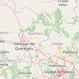
Map view of Sierra de los Agustinos

Use this park location map to pinpoint Sierra de los Agustinos in Mexico, understand its exact geographic position, and read its mapped placement within the surrounding landscape more clearly.

Pigeon | © OpenStreetMap contributors

Location context for Sierra de los Agustinos

Guanajuato

Visual exploration of mountain terrain, forest habitats, and regional protected-area geography.

Sierra de los Agustinos Photos: Scenery and Volcanic Landscapes

Visual documentation captures the dramatic volcanic ridges and varied forest zones defining Sierra de los Agustinos within the Bajio high plain. Photographic records reveal the stark contrast between lowland plains and elevated oak ecosystems across the protected terrain.

A landscape view showing flat fields with scattered trees in the foreground and a mountain range silhouetted against a blue and pink cloudy sky at dusk

Park atlas

Compare regional volcanic terrain and connected conservation areas across central Mexico.

Parks Near Sierra de los Agustinos and Related Protected Landscapes

Browsing other protected areas near Sierra de los Agustinos reveals shared volcanic geography and ecological corridors across the surrounding region. Comparing adjacent mountain ranges and reserves provides deeper context on regional hydrology, forest transition zones, and contiguous conservation lands.
National parkQuerétaro
About 47 km away#1 closest

Northeast

El Cimatario National Park: National Park Protected Landscape in Querétaro Region

Explore mapped boundaries and regional geography.

Investigate El Cimatario National Park, a protected national park located in Querétaro, Mexico. This entry offers detailed atlas-style insights into the park's protected landscape, its geographic setting within the region, and its clearly mapped boundaries. It serves as a focused point for understanding this specific natural area's place in broader geographic and conservation mapping.

Area
24.48 km²
Established
1982
IUCN
II
Relief
Mountain
National parkMexico
About 49 km away#2 closest

Northeast

Cerro de Las Campanas National Park: Detailed Protected Landscape and Geographic Context

Explore mapped boundaries and regional atlas information for this Mexican national park.

Cerro de Las Campanas National Park is a protected national park in Mexico, offering a specific focus for geographic discovery. Users can investigate its mapped boundaries and understand how this protected area fits into the larger atlas of Mexico's natural landscapes. This page serves as an authoritative entry point for appreciating the park's unique geographic identity and its significance as a protected natural entity within the country's conservation framework.

IUCN
II
A soft watercolor painting showing a panoramic view of rolling green hills, a winding waterway, and distant pinkish mountains under a light sky.
Protected areaGuanajuato
About 49 km away#3 closest

West

Lake Yuriria: Exploring the Protected Landscape and Volcanic Terrain of Guanajuato

A historic artificial wetland and Ramsar-recognized migratory bird habitat.

Lake Yuriria serves as a benchmark for landscape conservation in the Bajio region. Spanning an extensive wetland area within a volcanic basin, this protected zone provides essential habitat for over 140 bird species and remains a cornerstone of the regional geography for its water regulation and agricultural impact.

Area
72 km²
Established
1548
Relief
Lowland
Climate
Subtropical
A soft watercolor painting showing a rolling landscape of light green hills, gentle slopes, and sparse trees against a pale, distant mountain horizon.
Natural monumentGuanajuato
About 57 km away#4 closest

West

Siete Luminarias Natural Monument: Exploring Maar Volcanic Craters in Guanajuato

A protected volcanic landscape on the Mexican Plateau.

Siete Luminarias encompasses seven well-defined volcanic maars surrounding the town of Valle de Santiago. This natural monument illustrates a rare geological occurrence where ancient underground explosions created broad, flat-floored craters that remain as essential features of the local Bajio terrain and regional geologic identity.

Area
89.28 km²
Established
1997
Relief
Upland
Climate
Subtropical
National parkMichoacán
About 62 km away#5 closest

South

Cerro de Garnica National Park: Its Geography and Protected Landscape Identity

Explore mapped boundaries within Michoacán's natural terrain.

Cerro de Garnica National Park serves as a distinct protected area contributing to the geographic understanding of Michoacán. This page offers a focused view on its mapped boundaries and natural landscape characteristics, providing essential context for atlas exploration. Discover the park's specific identity as a national park and its place within the regional geography, highlighting its value for structured discovery.

Area
19.36 km²
Established
1936
IUCN
II
Relief
Mountain
National parkMichoacán
About 72 km away#6 closest

South

Insurgente José María Morelos y Pavón National Park: Mapped Protected Landscape in Michoacán

Discover its geographic context and protected area boundaries.

Explore Insurgente José María Morelos y Pavón National Park, a designated national park in Michoacán, Mexico. This page provides detailed insights into its protected status, mapped geographic features, and its role as a significant natural landscape within the regional atlas. Understand the park's protected boundaries and its contribution to the geographic understanding of Michoacán.

Area
71.92 km²
Established
1939
IUCN
II
Relief
Mountain
National parkState of Mexico
About 108 km away#7 closest

Southeast

Bosencheve National Park: National Park Protected Landscape within State of Mexico

Explore mapped boundaries and regional geographic context.

Bosencheve National Park, a key national park designation, offers a focused area for understanding protected landscapes and their geographic distribution. This entry provides detailed insights into its mapped boundaries and how it fits within the regional geography of the State of Mexico. It serves as a vital point for exploring Mexico's protected natural areas from a structured, atlas-driven perspective.

Area
146 km²
Established
1940
IUCN
II
Scope
Terrestrial
A watercolor illustration depicting a wide landscape with green fields, scattered bushes, and rolling hills in the background under a soft pink and yellow sky.
Protected areaMichoacán
About 119 km away#8 closest

West

Alberca de los Espinos: Volcanic Crater and Protected Wetland Geography in Michoacán

Highland crater lake within the Trans-Mexican Volcanic Belt

The protected basin of Alberca de los Espinos forms a striking volcanic landform. Deep within its 2,100-meter crater rim, the lake exhibits complex thermal stratification and seasonal color changes. This site serves as a vital component of the regional geography in Michoacán, blending geological character with recognized wetland status.

Area
1.42 km²
Established
2003
Relief
Upland
Climate
Temperate

Common questions about visiting, size, designation, and location context for Sierra de los Agustinos

Sierra de los Agustinos FAQs for park facts, access, geography, and protected area context

Find quick answers about Sierra de los Agustinos, including protected-area facts, park geography, trail and visitor context, and how the park fits into its surrounding country and regional landscape.
MoriAtlas Explorer

Continue Your Protected Areas Search Across the Global Atlas

Deepen your exploration by continuing the structured search for national parks and protected areas worldwide. Utilize the comprehensive filtering capabilities to compare different conservation landscapes and refine your understanding of global park geography. Discover more about the distribution and characteristics of protected natural areas.

Global natural geography