Mori Atlas logo
Protected landscapeSimbahan-Talagas Protected Landscape

A detailed look at the forested river catchments and dipterocarp geography of this Philippine protected area.

Simbahan-Talagas Protected Landscape: Mapping the Sierra Madre Watershed in Aurora Province

The Simbahan-Talagas Protected Landscape represents a significant ecological component of the northern Sierra Madre in Aurora province. This protected area safeguards the headwaters and upper catchments of the Simbahan and Talagas river systems, which flow toward the Casiguran Sound. Encompassing expansive dipterocarp forest canopies and rugged mountain ridges, the landscape acts as a vital hydrological anchor for the surrounding regions of Dinalungan.

Sierra Madrewatershed reservedipterocarp forestlowland rainforestPhilippine deer habitatbirdwatching

Simbahan-Talagas Protected Landscape

Protected landscape

Park overview

Structured park overview, official facts, and landscape profile for Simbahan, Talagas Protected Landscape

Simbahan, Talagas Protected Landscape park facts, protected area profile, and essential visitor context

Review the core facts for Simbahan, Talagas Protected Landscape, including designation, size, terrain, visitor scale, habitats, and operating context in one park-focused overview.

About Simbahan, Talagas Protected Landscape

Simbahan–Talagas Protected Landscape occupies a strategically important ecological position in northern Aurora, where the eastern slopes of the Sierra Madre descend toward the Pacific coast of Luzon. Designated by the Philippine government and administered by the Department of Environment and Natural Resources, the park combines watershed protection, biodiversity conservation, and landscape-scale habitat preservation in a single unit.

The terrain is shaped by forested ridge and valley systems typical of the northern Sierra Madre, with rivers and creeks draining eastward toward the Casiguran Sound. Vegetation is dominated by dipterocarp forest, a hallmark of the Philippines' lowland tropical forests. The canopy includes several commercially and ecologically important Shorea species: Shorea almon, known locally as Philippine mahogany; Shorea polysperma or tanguile; Shorea squamata, sometimes called mayapis; Shorea contorta, or white lauan; Shorea negrosensis, or red lauan; and Parashorea malaanonan, known as bagtikan. These species together define much of the visual and ecological character of the protected landscape.

Beyond its forest cover, the reserve incorporates mosaic land uses including cultivated plots, shrubland, open grassland, built-up areas, and natural river-wash zones. This mosaic reflects the long-standing relationship between the surrounding communities and the watershed, where forest, agriculture, and watercourses meet. The Sangay River and Umihiem Creek in Dinalungan are notable water features within the park, while the broader Simbahan and Talagas systems define the hydrological identity of the area.

Ecologically, the landscape shelters native mammals such as the Philippine deer and the Philippine long-tailed macaque, and it is recognized for hosting an abundant and diverse avifauna. As one of five protected areas in Aurora, it forms part of a regional network of reserves that together support the ecological integrity of the Sierra Madre corridor along the eastern seaboard of Luzon.

Quick facts and research context for Simbahan, Talagas Protected Landscape

Simbahan–Talagas Protected Landscape covers approximately 2,266 hectares in northern Aurora province on the island of Luzon in the Philippines. It sits within the north-central section of the Sierra Madre mountain range and preserves the headwaters of the Simbahan and Talagas river systems, including tributaries that drain through Dinalungan into Casiguran Sound. The area is classified as an IUCN Category V protected landscape and is administered by the Department of Environment and Natural Resources. It is one of five designated protected areas within Aurora and is dominated by lowland and lower montane dipterocarp forest.

Protection and recognition

Documented terrestrial protection scope, designation history, and recognition facts

Simbahan-Talagas Protected Landscape Protection Status and Recognition Data

Simbahan-Talagas Protected Landscape maintains a documented terrestrial protection scope within the global conservation framework. Official records compile verified protection metrics, management parameters, and international recognition data without external assumptions.

Protection details

Protection scope
Terrestrial
Transboundary protection
No
Park context

Deeper park guide and search-rich context for Simbahan, Talagas Protected Landscape

Simbahan, Talagas Protected Landscape history, landscape, wildlife, and travel context

Explore Simbahan, Talagas Protected Landscape through its history, landscape character, ecosystems, wildlife, conservation priorities, cultural context, and seasonal travel timing in a structured park guide built for atlas discovery and search intent.

Why Simbahan, Talagas Protected Landscape stands out

The protected landscape is best known for its role as a forest-covered watershed at the foot of the Sierra Madre, anchoring the water supply for the Simbahan and Talagas river systems. Its extensive dipterocarp stands, dominated by multiple Shorea species such as Philippine mahogany, tanguile, mayapis, and several lauan varieties, give the park a strong lowland rainforest identity. It is also recognized for sustaining populations of Philippine deer, Philippine long-tailed macaque, and a rich and abundant bird community within a relatively compact protected footprint.

Simbahan, Talagas Protected Landscape history and protected-area timeline

The area that now forms the Simbahan–Talagas Protected Landscape was first given formal protection on May 22, 1992, when it was established as a watershed forest reserve under the Philippine government. At that time, its primary purpose was to safeguard the forest cover and water yield of the Simbahan and Talagas river systems, which feed communities and downstream ecosystems in northern Aurora.

On April 23, 2000, the reserve's status was upgraded, and it was reclassified as a protected landscape under the country's expanding system of protected areas. This change broadened its mandate beyond watershed conservation to include the protection of scenic values, biodiversity, and the broader ecological character of the Sierra Madre landscape in which the reserve sits.

Today the park is administered by the Department of Environment and Natural Resources and stands as one of five protected areas in the province of Aurora, reflecting its continued importance for watershed management and biodiversity conservation in the region.

Simbahan, Talagas Protected Landscape landscape and geographic character

The landscape of Simbahan–Talagas Protected Landscape is defined by the eastern foothills and ridgelines of the Sierra Madre mountain range, the longest range in the Philippines. Terrain rises and falls in forested ridges intersected by river valleys, with creeks and rivers carving channels that ultimately drain toward the Casiguran Sound on the Pacific side of Luzon.

The dominant surface feature is the river network itself. The Simbahan and Talagas rivers originate within the park, accompanied by tributaries such as the Sangay River and Umihiem Creek, particularly in the Dinalungan area. These waterways shape the topography and create natural river-wash zones between forested slopes.

Much of the visible land cover is closed-canopy dipterocarp forest, giving the protected area a continuous green profile across its ridges and valleys. Where forest cover thins or gives way to human use, the landscape opens into cultivated plots, shrubland, and grassland patches, with small built-up areas reflecting rural settlement. This blend of intact forest and working landscape gives Simbahan–Talagas a varied but largely forested visual character.

Simbahan, Talagas Protected Landscape ecosystems, habitats, and plant life

Ecologically, Simbahan–Talagas Protected Landscape represents a core block of dipterocarp forest within the north-central Sierra Madre. Dipterocarps, particularly in the genus Shorea, dominate the canopy and are characteristic of the Philippines' most threatened lowland rainforest formations. The presence of multiple Shorea species, including Philippine mahogany, tanguile, mayapis, white lauan, red lauan, and bagtikan, indicates a relatively intact floristic community that supports a wide range of associated flora and fauna.

The park's habitats range from closed-canopy lowland and lower montane forest to more open shrubland, grassland, and riparian zones along the Simbahan, Talagas, Sangay, and Umihiem watercourses. These varied habitats create gradients of light, moisture, and structure that support different ecological niches.

Within this matrix of forest and riparian environments, the protected landscape provides refuge for native mammals, including the Philippine deer and the Philippine long-tailed macaque, and supports an especially rich avifauna. The combination of extensive dipterocarp forest, topographic diversity, and proximity to the Sierra Madre corridor makes the area an important node for forest-dependent species in Aurora.

Simbahan, Talagas Protected Landscape wildlife and species highlights

The wildlife profile of Simbahan–Talagas Protected Landscape is anchored by species typical of the Sierra Madre's dipterocarp forests. Among the most notable mammals is the Philippine deer, a species endemic to the country and an indicator of relatively intact forest cover, alongside the Philippine long-tailed macaque, which is commonly associated with primary and secondary lowland forest in the Philippines.

The park also supports an abundant and diverse avifauna. The mix of closed-canopy forest, forest edge, riparian habitat, and adjacent open areas provides feeding and nesting conditions for a wide range of bird species, contributing to the park's recognition for bird richness relative to its size.

Other wildlife, including smaller mammals, reptiles, amphibians, and invertebrates typical of Sierra Madre lowland forests, is also supported by the landscape, although they are less prominently featured in the park's documentation. Together, the mammal and bird communities reinforce the ecological value of the protected landscape as a habitat refuge within the broader Aurora protected-area network.

Simbahan, Talagas Protected Landscape conservation status and protection priorities

Simbahan–Talagas Protected Landscape plays a central role in watershed and forest conservation in northern Aurora. Its initial designation as a watershed forest reserve in 1992 reflected the importance of its forests for regulating water flow in the Simbahan and Talagas river systems, which supply downstream users and ultimately discharge into the Casiguran Sound.

The 2000 reclassification as a protected landscape broadened this focus, aligning the area with the national protected-area framework that integrates biodiversity, scenic, and hydrological values under a single conservation regime. Administered by the Department of Environment and Natural Resources, the park sits within a provincial network of five protected areas that collectively strengthen the Sierra Madre's role as a continuous ecological corridor along eastern Luzon.

From a conservation perspective, the park's significance lies in its remaining dipterocarp forest cover, its watershed functions, and its capacity to support native wildlife such as the Philippine deer and a rich avifauna. Maintaining this combination of ecological services and habitat value is the park's central conservation purpose.

Simbahan, Talagas Protected Landscape cultural meaning and human context

The cultural context of Simbahan–Talagas Protected Landscape is closely tied to the rural communities of northern Aurora, particularly in Dinalungan and surrounding municipalities. The presence of cultivated land, shrub patches, and small built-up areas within the park reflects long-standing patterns of forest-edge settlement, small-scale agriculture, and the use of forest resources by local communities.

Rivers like the Simbahan, Talagas, Sangay, and Umihiem are not only ecological features but also part of the daily life of nearby residents, supporting livelihoods such as farming, fishing, and watershed-dependent activities. The park therefore sits at the intersection of traditional human land use and modern conservation management, a common pattern for watershed reserves in the Sierra Madre.

Top sights and standout views in Simbahan, Talagas Protected Landscape

Simbahan–Talagas Protected Landscape stands out for the combination of an intact dipterocarp forest canopy, a critical Sierra Madre watershed, and a compact but ecologically rich protected footprint. Multiple Shorea species define its canopy, while the Simbahan and Talagas river headwaters, along with tributaries in Dinalungan, anchor its hydrological identity. The presence of Philippine deer, Philippine long-tailed macaque, and a thriving avifauna underscores its biodiversity value, and its status as one of five protected areas in Aurora places it within an important regional conservation network.

Best time to visit Simbahan, Talagas Protected Landscape

The park's experience is shaped largely by the tropical climate of eastern Luzon, where a pronounced dry season generally runs from roughly November through May and a wet season prevails from June through October. The drier months typically offer more stable conditions for forest walks, river observation, and wildlife viewing, while the wetter months can bring heavier rainfall that swells rivers and may complicate access along forest and watershed trails.

Bird activity in dipterocarp forest areas of the Sierra Madre can vary through the year, with drier conditions often favoring more predictable observation along ridges and forest edges. Travelers interested in the broader scenery of the Sierra Madre and the Casiguran Sound area may find the dry season generally more comfortable for outdoor exploration, while the wet season emphasizes the watershed character of the park with fuller rivers and lusher vegetation.

Monthly climate preview

Long-term temperature and precipitation averages across the representative coordinate

Simbahan-Talagas Protected Landscape Climate and Monthly Weather Patterns

Representative coordinate records show measured multi-year averages for monthly temperature ranges and daily precipitation totals at Simbahan-Talagas Protected Landscape. Detailed twelve-month climatology data allows direct comparison of long-term weather rhythms across the protected area.
Annual mean26 °C
24 °C28 °C
Jan24°
Feb24°
Mar25°
Apr26°
May28°
Jun28°
Jul27°
Aug27°
Sep27°
Oct27°
Nov26°
Dec25°
Warmest month
June

27.7 °C

Coolest month
January

24.1 °C

Wettest month
October

10.7 mm/day

Driest month
February

3.4 mm/day

Park location guide

Geography guide, regional context, and park location map for Simbahan, Talagas Protected Landscape

Simbahan, Talagas Protected Landscape park geography, regions, and map view in Philippines

Understand where Simbahan, Talagas Protected Landscape sits in Philippines through a broader geographic reading of the surrounding landscape, nearby location context, and its mapped position within the national park landscape.

How Simbahan, Talagas Protected Landscape fits into Philippines

The Philippines, officially the Republic of the Philippines, is an archipelagic nation in Southeast Asia comprising approximately 7,641 islands categorized into three main geographical divisions: Luzon, Visayas, and Mindanao. Located in the western Pacific Ocean, it shares maritime borders with Taiwan, Japan, Palau, Indonesia, Malaysia, Vietnam, and China. Manila serves as the capital city, while Quezon City is the most populated city, both within Metro Manila.

Wider geography shaping Simbahan, Talagas Protected Landscape in Philippines

The Philippines is an archipelagic nation in Southeast Asia, positioned in the western Pacific Ocean. Its islands are bounded by the South China Sea to the west, Philippine Sea to the east, and Celebes Sea to the south. The country shares maritime borders with Taiwan to the north, Japan to the northeast, Palau to the east and southeast, Indonesia to the south, Malaysia to the southwest, Vietnam to the west, and China to the northwest.

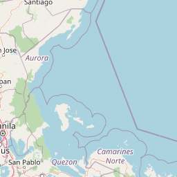
Map view of Simbahan, Talagas Protected Landscape

Use this park location map to pinpoint Simbahan, Talagas Protected Landscape in Philippines, understand its exact geographic position, and read its mapped placement within the surrounding landscape more clearly.

Pigeon | © OpenStreetMap contributors

Location context for Simbahan, Talagas Protected Landscape

Aurora
Park atlas

Compare adjacent Sierra Madre forest reserves and regional conservation landscapes

Parks Near Simbahan-Talagas Protected Landscape and Surrounding Regional Protected Areas

Browse nearby protected areas and mountain watersheds located across the surrounding Sierra Madre region. Extending your geographic comparison reveals broader ecological patterns and connected river systems.
Protected landscapeAurora
About 6.1 km away#1 closest

Northeast

Talaytay Protected Landscape: Geography and Protected Area Mapping in Aurora Province

Sierra Madre mountain-to-coast watershed exploration

Analyze the topographic profile and protected boundaries of Talaytay Protected Landscape. This reserve serves as a significant ecological corridor in Aurora, connecting the Sierra Madre interior to the Pacific coast through a series of forested riverine valleys and steep mountain slopes.

Area
35.26 km²
Established
2000
IUCN
V
Relief
Mountain
A watercolor painting of rolling green hills, trees, and wildflowers on a white background, with a soft, artistic style.
Protected landscapeQuirino
About 30 km away#2 closest

North

Quirino Protected Landscape: Exploring the Sierra Madre and Cagayan River Watershed

Mountainous forest geography in the province of Quirino

Spanning roughly two thirds of the province of Quirino, this protected landscape is a strategic natural feature of northern Luzon. Defined by the confluence of the Sierra Madre and Caraballo mountain ranges, it serves as a massive reservoir for the Upper Cagayan River. The terrain consists of dense rainforest ridges, deep river valleys, and isolated peaks, playing a central role in regional biodiversity and watershed conservation.

Area
1,759.44 km²
Established
2004
IUCN
V
Relief
Mountain
National parkNueva Vizcaya
About 69 km away#3 closest

Northwest

Bangan Hill National Park: A Protected Landscape within Nueva Vizcaya's Geography

Explore its mapped terrain and cultural significance.

Bangan Hill National Park is a crucial protected area nestled in Nueva Vizcaya, Philippines. This page details its specific geography, including its role as a distinct hill within the broader Cagayan Valley landscape. Users can explore the park's mapped boundaries, understand its role as a national park, and discover the surrounding mountain context of the Caraballo and Cordillera Central ranges. It offers a unique perspective on the region's natural and historical significance, serving as a focal point for protected landscape exploration.

Area
0.139 km²
Established
1995
IUCN
II
Relief
Mixed relief
A horizontal watercolor painting showing layers of distant rolling mountains behind a forested midground and a foreground of light vegetation.
Wildlife reserveNueva Ecija
About 83 km away#4 closest

West

Pantabangan, Carranglan Watershed Forest Reserve: Geography and Protected Area Context

Mountainous watershed landscapes in Northern Nueva Ecija

Spanning the meeting point of the Sierra Madre and Caraballo mountains, this protected wildlife reserve encompasses the massive Pantabangan Lake reservoir. The region provides a complex look at how natural forest ecosystems and large-scale water management infrastructure integrate within the Philippine landscape, offering a unique perspective on regional hydrology and botanical biodiversity.

Area
845 km²
Established
1969
IUCN
VI
Relief
Mountain
National parkPhilippines
About 89 km away#5 closest

Southwest

Aurora Memorial National Park: A Protected Landscape in the Philippines' Sierra Madre

Explore mapped boundaries and endemic avian habitat.

Aurora Memorial National Park represents a critical conservation area situated within the Philippines' Sierra Madre mountain range. Spanning a significant stretch along the eastern mountain slopes, this national park is characterized by its lowland dipterocarp forest ecosystem, recognized for supporting diverse flora and fauna. It is particularly noted as an Important Bird Area, crucial for endemic species like the Philippine eagle and various other avian populations, highlighting its ecological significance within the archipelago's geography.

Area
56.76 km²
Established
1937
IUCN
V
Relief
Mountain
National parkPhilippines
About 105 km away#6 closest

North

Fuyot Springs National Park: Philippines Protected Area with Springs, Caves & Waterfalls

Explore Sierra Madre mountain terrain and natural landscape features.

Fuyot Springs National Park offers a detailed look at a unique protected landscape within the Philippines' Sierra Madre mountain range. This atlas perspective focuses on the park's defining natural springs, its exploration-ready cave systems such as Main Cave and Altar Cave, and scenic features like Pinzal Falls. Understand the geographic context of this protected area and its mountainous terrain for landscape discovery.

Area
8.19 km²
Established
1938
IUCN
V
Relief
Mountain
A soft, artistic watercolor illustration of a river winding through green rolling hills and mountain terrain.
Protected landscapePhilippines
About 123 km away#7 closest

West

Lower Agno Watershed Forest Reserve: Watershed Geography and Mountain Terrain in the Philippines

A vital river corridor and pine forest protected landscape

Explore the structured geography of the Lower Agno Watershed Forest Reserve, defined by its 34.59 kilometer river corridor and dense network of tributaries. From the Benguet pine forests of the Cordillera Central to the industrial landscape surrounding the San Roque Dam, this reserve serves as a complex model of water management, rugged mountain topography, and long term mining heritage in the Philippine highlands.

Area
393.04 km²
Established
1983
IUCN
V
Relief
Mountain
Illustration of a river with bamboo boats, people rowing, limestone cliffs, and trees
National parkNueva Ecija
About 123 km away#8 closest

Southwest

Minalungao National Park: Protected Landscape and Geographic Context in Nueva Ecija

Explore the mapped boundaries of this Philippines national park.

Delve into the specifics of Minalungao National Park, a protected natural area identified as a national park in the Philippines. This exploration focuses on its distinct geographic identity within Nueva Ecija, highlighting the importance of its mapped boundaries and regional landscape. Understand the park's role as a protected land entity for atlas-based discovery.

Area
20.18 km²
Established
1967
IUCN
V
Relief
Upland

Common questions about visiting, size, designation, and location context for Simbahan, Talagas Protected Landscape

Simbahan, Talagas Protected Landscape FAQs for park facts, access, geography, and protected area context

Find quick answers about Simbahan, Talagas Protected Landscape, including protected-area facts, park geography, trail and visitor context, and how the park fits into its surrounding country and regional landscape.
MoriAtlas Explorer

Continue Your Protected Areas Search Across the Global Atlas

Deepen your exploration by continuing the structured search for national parks and protected areas worldwide. Utilize the comprehensive filtering capabilities to compare different conservation landscapes and refine your understanding of global park geography. Discover more about the distribution and characteristics of protected natural areas.

Global natural geography