Mori Atlas logo
National parkSingle National Park

Discover the mapped boundaries and natural terrain of this significant protected area in New South Wales.

Single National Park National Park: Protected Landscape and Geographic Atlas

Single National Park stands as a prominent protected area within New South Wales, offering a distinct perspective on Australia's natural landscapes. This canonical page provides detailed geographic context and mapped park boundaries, ideal for atlas-driven exploration. Understand its unique place within the regional geography and explore the foundational elements of its protected landscape, essential for a structured understanding of conservation areas.

New South Wales national parksAustralian protected areasNew England regionIUCN Category IIHighland protected areaNew South Wales conservation

Single National Park

National park

Park overview

Structured park overview, official facts, and landscape profile for Single National Park

Single National Park park facts, protected area profile, and essential visitor context

Review the core facts for Single National Park, including designation, size, terrain, visitor scale, habitats, and operating context in one park-focused overview.

About Single National Park

Single National Park is a protected natural area located in northern New South Wales, Australia, approximately 432 kilometers north of Sydney. Established in 1999, the park covers an area of 25.63 square kilometers and occupies elevated terrain in the New England region of the state. The park is managed by the NSW National Parks and Wildlife Service and represents a protected landscape within Australia's national park system. The terrain features undulating hills and forested slopes typical of the highland areas in this part of New South Wales, with an average elevation around 1,033 meters above sea level. As a Category II protected area under the IUCN classification system, the park contributes to the conservation of native ecosystems and biodiversity in the New England tablelands region.

Quick facts and research context for Single National Park

Single National Park is situated in the New England region of New South Wales, occupying elevated terrain at approximately 1,033 meters average elevation. The protected area spans 25.63 square kilometers and was formally established in 1999 under the management of the NSW National Parks and Wildlife Service. The park is classified as an IUCN Category II national park, indicating its primary purpose of protecting natural ecosystems while allowing for sustainable visitor use. Its location about 432 kilometers north of Sydney places it within a broader network of protected areas in the northern tablelands of New South Wales.

Protection and recognition

Documenting the terrestrial management scope and official protected area status

Single National Park Protection Status and Conservation Designation

Understanding the terrestrial protection status and formal designation history of Single National Park provides essential geographic context for the region. Mapping the official management scope and conservation boundaries helps researchers and explorers evaluate verified global environmental data.

Protection details

Protection scope
Terrestrial
Transboundary protection
No
Monthly climate preview

Long-term temperature and precipitation cycles from a representative elevation of 849 meters

Single National Park Monthly Weather Averages and Climate Profile

Representative climatology data from 1991 to 2020 indicates a distinct thermal rhythm for Single National Park, featuring warm maximums above 30 degrees Celsius alongside winter minimums that drop below freezing. Accessing the complete twelve-month profile reveals detailed daily precipitation averages and monthly temperature spreads across the protected landscape of New South Wales.
Annual mean15 °C
7 °C23 °C
Jan23°
Feb22°
Mar19°
Apr16°
May11°
Jun
Jul
Aug
Sep12°
Oct16°
Nov19°
Dec21°
Warmest month
January

22.6 °C

Coolest month
July

7.4 °C

Wettest month
December

3.4 mm/day

Driest month
April

1.1 mm/day

Park location guide

Geography guide, regional context, and park location map for Single National Park

Single National Park park geography, regions, and map view in Australia

Understand where Single National Park sits in Australia through a broader geographic reading of the surrounding landscape, nearby location context, and its mapped position within the national park landscape.

How Single National Park fits into Australia

Australia is a constitutional monarchy and federal parliamentary democracy comprising six states and ten territories. With a population of nearly 28 million, it is one of the world's most urbanised countries, with most people concentrated on the eastern seaboard. The country has a high Human Development Index and is known for its cultural diversity, ancient Aboriginal heritage, and unique wildlife.

Wider geography shaping Single National Park in Australia

Australia occupies the entire Australian continent, the island of Tasmania, and numerous smaller islands. It is the world's flattest and driest inhabited continent, featuring vast deserts in the interior (the Outback), tropical rainforests along the eastern coast, and a coastline bordering the Indian and Pacific Oceans.

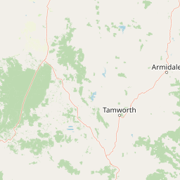
Map view of Single National Park

Use this park location map to pinpoint Single National Park in Australia, understand its exact geographic position, and read its mapped placement within the surrounding landscape more clearly.

Pigeon | © OpenStreetMap contributors

Location context for Single National Park

New South Wales
Park atlas

Compare surrounding protected areas and trace the regional park geography beyond Single National Park.

National Parks and Protected Areas Near Single National Park in the New England Region

After exploring Single National Park, continue your discovery by browsing other national parks and protected areas across the New England region of New South Wales, Australia. Compare different conservation landscapes and understand the broader geographic context of protected areas within the Australian national park system.
National parkNew South Wales
About 16 km away#1 closest

Southwest

Indwarra National Park: New South Wales National Park Protected Landscape and Geographic Context

Explore mapped park boundaries and regional geography.

Indwarra National Park is identified as a significant protected area within New South Wales, Australia, offering a unique focus for geographic exploration. As a national park, its mapped boundaries define a distinct natural landscape. This page provides detailed atlas-style information, enabling a deeper understanding of its terrain, regional context, and protected-area significance for structured discovery.

Area
9 km²
Established
1999
IUCN
Ia
Relief
Mountain
Nature reserveNew South Wales
About 36 km away#2 closest

East

Little Llangothlin Nature Reserve: Exploring the New England Plateau Wetlands and Landscape

High-elevation freshwater lagoons and basalt landscapes in New South Wales

Little Llangothlin Nature Reserve stands as a preserved fragment of the New England Tablelands. This high-elevation wetland habitat provides essential refuge for diverse species, showcasing rare sedgeland, herbland, and woodland communities within a landscape dominated by agricultural development.

Area
2.57 km²
Established
1979
IUCN
IV
Relief
Upland
National parkNew South Wales
About 38 km away#3 closest

North

Kings Plains National Park: National Park Protected Area and Geographic Context

Explore mapped boundaries and landscape details for this New South Wales park.

Kings Plains National Park represents a distinct protected area entity within New South Wales, Australia. This national park serves as a focal point for understanding specific geographic features and its mapped boundaries. Users engaging with this park profile can uncover its regional landscape context and explore its significance as part of a larger atlas of protected natural areas. The focus remains on its geographic identity and atlas-based discovery value.

Area
57 km²
Established
1988
IUCN
II
Access
Moderate access
National parkNew South Wales
About 47 km away#4 closest

East

Warra National Park: Protected Landscape Identity and Geographic Setting in New South Wales

Mapped boundaries and regional natural terrain context.

Warra National Park represents a key protected area, offering critical insights into the natural geography of New South Wales, Australia. This detail page focuses on its identity as a national park, detailing its mapped boundaries and the surrounding landscape context. Understand the specific geographic features and the protected land designation that define Warra National Park, enhancing your atlas exploration with precise regional details.

Area
19.2 km²
Established
1999
IUCN
II
Relief
Highland
Watercolor illustration of rolling hills, green forests, and pink flowering trees
National parkNew South Wales
About 60 km away#5 closest

East

Guy Fawkes River National Park: National Park Geographic Context and Mapped Boundaries

Explore the protected landscape and regional geography of this New South Wales national park.

Gain a structured understanding of Guy Fawkes River National Park, a key national park in New South Wales, Australia. This entry provides detailed insights into its mapped geographic boundaries, its role as a protected landscape, and its contribution to the broader regional context for atlas exploration. Examine the park's place within the natural terrain of New South Wales for a clearer picture of conservation lands.

Area
1,005.9 km²
Established
1972
IUCN
Ib
Relief
Highland
Nature reserveNew South Wales
About 71 km away#6 closest

Northeast

Mann River Nature Reserve: Geography and Protected Forest Terrain in New South Wales

Highland river valleys and Great Dividing Range landscapes

Spanning over 7,000 hectares of rugged highland terrain, Mann River Nature Reserve provides a vital protected habitat within the Northern Tablelands. The landscape is defined by the incision of the Mann River through deep, forested gorges and sharp mountain ridges, creating a distinct physical setting that serves as a sanctuary for native Australian wildlife.

Area
71.28 km²
Established
1985
IUCN
II
Relief
Mountain
National parkNew South Wales
About 71 km away#7 closest

Southwest

Warrabah National Park: Discover Protected Landscape and Mapped Geography in New South Wales

Explore the geographic context of this Australian national park.

Warrabah National Park is a designated national park in New South Wales, Australia, offering critical insights into protected area geography. This resource details its mapped boundaries and its place within the region's natural landscape. Understand the park's protected land identity and its contribution to the broader geographical atlas, providing a foundation for focused landscape exploration.

Area
34.71 km²
Established
1984
IUCN
II
Relief
Highland
National parkNew South Wales
About 75 km away#8 closest

Northeast

Barool National Park: National Park Discovery and Geographic Context

Mapped protected area within New South Wales.

Barool National Park is identified as a protected national park, contributing to the rich tapestry of natural landscapes across New South Wales. Understanding its specific location and mapped boundaries is essential for appreciating its role within the regional geography of Australia. This entry provides a factual basis for exploring the park's identity as a defined protected area, offering a unique point of reference for geographic discovery.

Area
112.44 km²
Established
1999
IUCN
II
Climate
Temperate

Common questions about visiting, size, designation, and location context for Single National Park

Single National Park FAQs for park facts, access, geography, and protected area context

Find quick answers about Single National Park, including protected-area facts, park geography, trail and visitor context, and how the park fits into its surrounding country and regional landscape.
MoriAtlas Explorer

Continue Your Protected Areas Search Across the Global Atlas

Deepen your exploration by continuing the structured search for national parks and protected areas worldwide. Utilize the comprehensive filtering capabilities to compare different conservation landscapes and refine your understanding of global park geography. Discover more about the distribution and characteristics of protected natural areas.

Global natural geography