Mori Atlas logo
Protected areaSlieveanorra Forest

Analyzing the terrain, upland conifer forests, and glacial valley features across the region.

Slieveanorra Forest: Mapped Geography and Protected Landscapes of County Antrim

Slieveanorra Forest defines a unique upland landscape across the rolling interior of County Antrim. This protected area integrates vast conifer plantations with reservoir networks, glacial valleys, and prominent summits like Orra Mountain. This documentation examines the physical terrain, ecological boundaries, and distinct geography that shape the forest and its surroundings within Northern Ireland.

conifer forestworking forestupland forestreservoir landscapeArea of Special Scientific Interestpanoramic viewpoint

Slieveanorra Forest

Protected area

Park overview

Structured park overview, official facts, and landscape profile for Slieveanorra Forest

Slieveanorra Forest park facts, protected area profile, and essential visitor context

Review the core facts for Slieveanorra Forest, including designation, size, terrain, visitor scale, habitats, and operating context in one park-focused overview.

About Slieveanorra Forest

Slieveanorra Forest occupies a broad section of the Antrim uplands in northeastern Northern Ireland, stretching across a region of rounded hills, forested valleys, and reservoir-laced catchments. The forest is conifer-dominated, with extensive plantations that give the landscape its dark green, textured character and that frame several walking routes. Although it is a managed, working woodland, the forest also retains areas of natural and semi-natural interest where boggy ground, exposed rock, and varied understorey create habitat variety.

The forest's identity is closely bound up with its mountain backdrop. Orra Mountain is the dominant high point within the woodland, and its summit is one of the main reasons walkers come to Slieveanorra. On clear days, the view from the top reaches far beyond County Antrim, sweeping north toward the Hebrides and south toward the Mourne Mountains, giving the forest a strong sense of open, elevated scenery despite its relatively contained footprint.

At its edges, the forest meets water. Altnahinch Dam lies along the boundary of the woodland, and its reservoir shoreline draws steady summer attention from visitors, walkers, and families. The combination of conifer plantations, damside paths, and panoramic ridge walks gives Slieveanorra a layered character that shifts noticeably from dense forest interior to open water and skyline.

Ecologically, the forest is more than a single block of conifers. It supports a range of animal and plant life, including crossbills among the trees and dragonflies along the wetter margins, while foxes and frogs are part of the broader woodland fauna. A designated section within the forest is recognized as an Area of Special Scientific Interest, lending the landscape formal ecological weight alongside its working forestry role. Together, these elements make Slieveanorra a forest shaped by both human management and natural ecological value.

Quick facts and research context for Slieveanorra Forest

Slieveanorra Forest is a large conifer plantation in the northern part of County Antrim, Northern Ireland, positioned inland from the A2 coast road near Cushendall. It surrounds Orra Mountain, whose summit provides long panoramic views, and adjoins Altnahinch Dam, one of the local reservoirs that attract visitors in the warmer months. A portion of the forest carries formal ecological recognition as an Area of Special Scientific Interest, and the wider landscape includes the upland of Slieve-na-Aura, site of the historic Battle of Aura.

Park context

Deeper park guide and search-rich context for Slieveanorra Forest

Slieveanorra Forest history, landscape, wildlife, and travel context

Explore Slieveanorra Forest through its history, landscape character, ecosystems, wildlife, conservation priorities, cultural context, and seasonal travel timing in a structured park guide built for atlas discovery and search intent.

Why Slieveanorra Forest stands out

Slieveanorra Forest is best known for sweeping views from the summit of Orra Mountain, its expanse of planted conifer woodland, and the reservoirs around its edges. It is also recognized for its mix of upland plant communities, resident wildlife such as crossbills and dragonflies, and a wartime memorial recalling an American bomber crash during the Second World War.
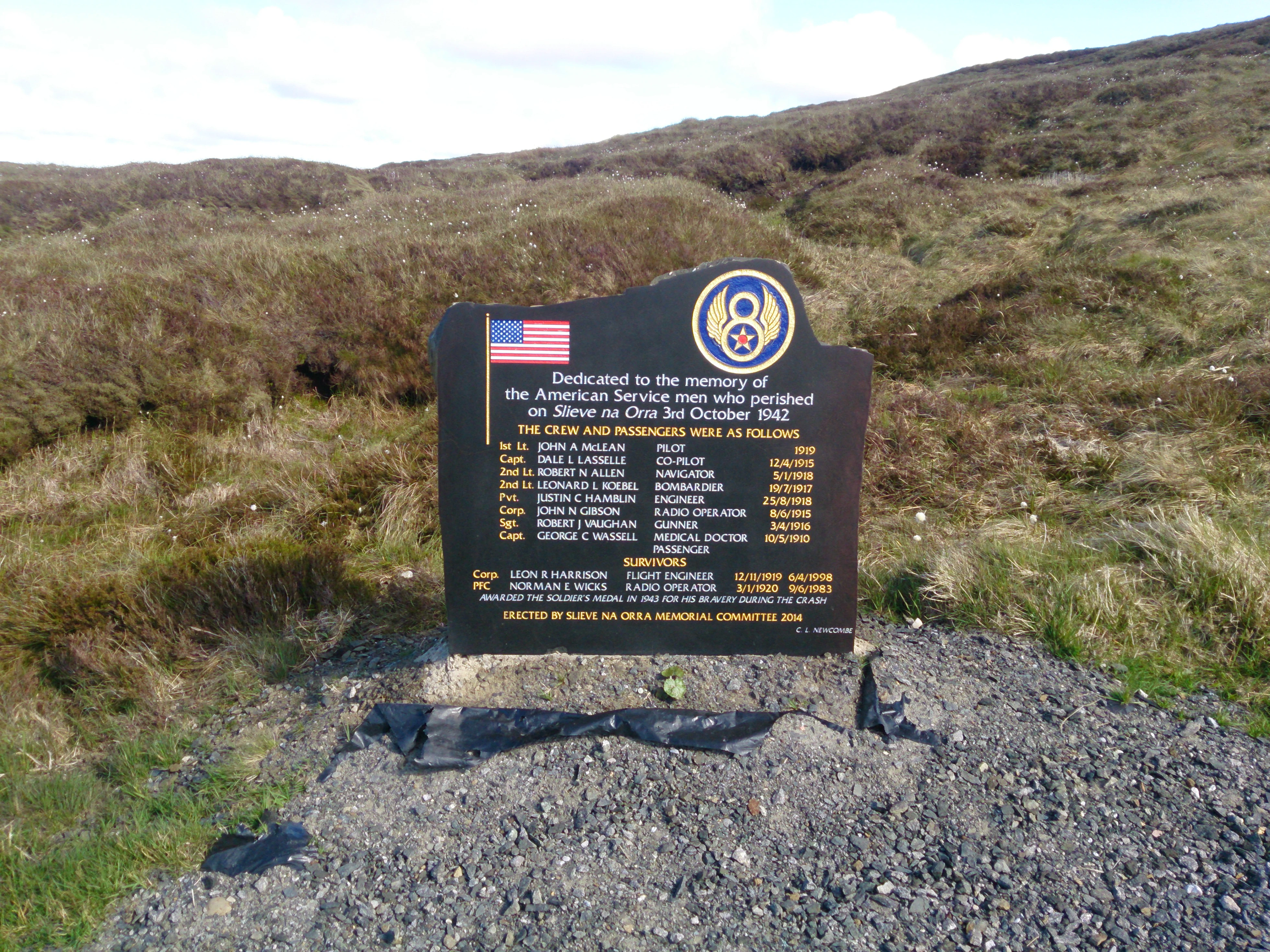
A black memorial plaque with an American flag and 8th Air Force emblem listing names of servicemen, set on a gravel base in a grassy, hilly landscape.
Memorial plaque dedicated to American servicemen who died in a 1942 plane crash on Slieveanorra Mountain.

Slieveanorra Forest history and protected-area timeline

Slieveanorra Forest takes its English name from the surrounding mountain Slieveanorra, derived from the Irish Sliabh an Earra, meaning 'mountain of the tail' or 'mountain of the ridge.' The wider upland around the forest carries deeper historical resonance, since the nearby mountain Slieve-na-Aura was the site of the Battle of Aura, an early medieval engagement fought in the surrounding terrain.

In the twentieth century, the forest became associated with a different kind of history. In October 1942, during the Second World War, a United States Air Force B17 Flying Fortress bomber crashed into a mountainside beside the woodland. The accident killed eight of the ten personnel on board, and a memorial board now marks the location as a quiet reminder of the wartime activity that once passed over these hills.

The forest itself developed as a working conifer plantation in the modern era, with management and access shaped by the surrounding road network and by the reservoirs at its edges. Its current character reflects both long-standing upland land use and more recent forestry and water-resource development.

Slieveanorra Forest landscape and geographic character

Slieveanorra Forest sits within a region of soft, rolling uplands typical of the northern Antrim interior. The terrain is shaped by glacial and post-glacial processes, leaving a landscape of rounded summits, broad valleys, peaty ground, and scattered rock exposures. Conifer plantations dominate much of the visible land cover, giving the slopes a dark, even texture that contrasts with lighter patches of bog, heather, and rough grazing land.

Slieveanorra Forest ecosystems, habitats, and plant life

Beneath its uniform conifer canopy, Slieveanorra Forest contains a varied pattern of habitats. Dense plantation woodland transitions into wetter margins along streams and reservoir edges, where boggy ground, open water, and marginal vegetation create conditions for more specialized species. The mix of upland forestry, water bodies, and surrounding rough ground gives the area a layered ecological structure, and part of the forest is formally recognized for its environmental value through an Area of Special Scientific Interest designation.

Slieveanorra Forest conservation status and protection priorities

Slieveanorra Forest carries formal ecological recognition through a designated Area of Special Scientific Interest within its boundary, indicating that part of the woodland and its associated habitats meet defined criteria for nature conservation. This designation underlines the value of the forest beyond its commercial forestry role, recognizing the importance of its upland habitat mosaic, vegetation patterns, and associated wildlife. The conservation status also connects to the broader protected-area network in Northern Ireland, within which the forest contributes to the retention of upland and woodland habitats in the Antrim interior.

Slieveanorra Forest cultural meaning and human context

The forest's name preserves an older layer of place-naming in the region, deriving from the Irish Sliabh an Earra and linking the modern plantation landscape to the underlying mountain identity of the Antrim uplands. The wider area around the forest also carries deeper cultural memory through the Battle of Aura on neighboring Slieve-na-Aura, an event that places the surrounding mountains in the early historical landscape of Ireland. In the twentieth century, the forest became a site of wartime memory as well, with a memorial to American airmen who died in the 1942 bomber crash nearby.

Top sights and standout views in Slieveanorra Forest

The most distinctive features of Slieveanorra Forest are the panoramic summit views from Orra Mountain, the wide expanse of conifer woodland that surrounds it, and the reservoirs along the forest edge, including Altnahinch Dam. The forest's mix of working plantation, designated ecological interest, and quiet historical sites gives it a layered identity within the Antrim uplands.

Best time to visit Slieveanorra Forest

Slieveanorra Forest is most rewarding in the warmer months, when the reservoirs around the forest edge attract visitors and the walking routes through the conifer plantations are at their most accessible. Clear, settled weather is especially valuable here, since the panoramic views from the summit of Orra Mountain, across to the Hebrides and the Mourne Mountains, depend on good visibility. Outside summer, the forest takes on a quieter, more muted character, with denser conifer shade and more subdued wildlife activity.
Monthly climate preview

Long-term representative temperature and precipitation averages for County Antrim

Slieveanorra Forest Climate Normals and Monthly Temperature Rhythm

Representative coordinates record measured multi-year temperature variations alongside steady monthly precipitation totals across Slieveanorra Forest. Complete twelve-month records provide granular context for studying annual climate patterns across the protected landscape.
Annual mean9 °C
5 °C14 °C
Jan
Feb
Mar
Apr
May10°
Jun13°
Jul14°
Aug14°
Sep13°
Oct10°
Nov
Dec
Warmest month
August

14.3 °C

Coolest month
January

5.1 °C

Wettest month
November

3.9 mm/day

Driest month
May

2.4 mm/day

Park location guide

Geography guide, regional context, and park location map for Slieveanorra Forest

Slieveanorra Forest park geography, regions, and map view in United Kingdom

Understand where Slieveanorra Forest sits in United Kingdom through a broader geographic reading of the surrounding landscape, nearby location context, and its mapped position within the national park landscape.

How Slieveanorra Forest fits into United Kingdom

The United Kingdom is a parliamentary constitutional monarchy located in northwestern Europe, consisting of four constituent countries: England, Scotland, Wales, and Northern Ireland. As a major global power with over 69 million residents, it maintains significant international influence in politics, economics, and culture.

Wider geography shaping Slieveanorra Forest in United Kingdom

The United Kingdom is an island nation located in northwestern Europe, surrounded by the Atlantic Ocean, North Sea, English Channel, Celtic Sea, and Irish Sea. It shares a land border with the Republic of Ireland to the west. The territory includes the island of Great Britain, the northeastern portion of Ireland, and most of the smaller British Isles islands.

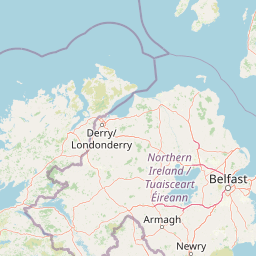
Map view of Slieveanorra Forest

Use this park location map to pinpoint Slieveanorra Forest in United Kingdom, understand its exact geographic position, and read its mapped placement within the surrounding landscape more clearly.

Pigeon | © OpenStreetMap contributors

Location context for Slieveanorra Forest

County AntrimNorthern Ireland

Visualizing the conifer plantations, upland terrain, and reservoir edges of County Antrim

Slieveanorra Forest Photos and Landscape Scenery Visual Exploration

Visual records capture the distinctive topography, working forest structure, and upland habitats that define Slieveanorra Forest. Examining these protected area scenes reveals the complex terrain, summit viewpoints, and glacial valley landscapes across Northern Ireland.

A black memorial plaque with an American flag and 8th Air Force emblem listing names of servicemen, set on a gravel base in a grassy, hilly landscape.

A wooden sign reading Slieveanorra stands in a heather-covered moorland with a dark conifer forest and misty hill visible in the background

Park atlas

Compare nearby upland landscapes, conifer forests, and regional nature reserves

Parks Near Slieveanorra Forest and Surrounding Protected Areas

Browse other parks and protected areas located near Slieveanorra Forest across the Antrim uplands. Comparing adjacent regional terrain helps trace wider patterns of forestry, glacial valleys, and reservoir landscapes.
Protected areaCounty Antrim
About 29 km away#1 closest

Northwest

Benbane Head Protected Area: Geographic Profile and Regional Landscape Mapping

Coastal terrain and protected boundaries in County Antrim

Examine the geographic characteristics of Benbane Head, a significant protected area located in County Antrim. This profile highlights the site's physical boundaries and its place within the regional landscape, providing essential mapping context for understanding Northern Ireland's diverse natural terrain and conservation geography.

Area
0.052 km²
Established
1953
Relief
Lowland
Climate
Temperate
Nature reserveNorthern Ireland
About 32 km away#2 closest

Southwest

Lough Beg Nature Reserve: Mapping the Wetlands and Floodplains of Northern Ireland

An essential protected landscape within the Lough Neagh basin.

Lough Beg provides a distinct geographic study of freshwater ecosystems and alluvial landscapes. As a designated nature reserve, it forms a crucial link in the Lower Bann catchment, characterized by its shallow waters and seasonal pasture flooding. The area serves as a primary hub for migratory bird species, while the historic Church Island offers a unique convergence of early Christian heritage and natural wetland terrain.

Relief
Lowland
Climate
Temperate
Access
Easy access
Scope
Terrestrial
Nature reserveNorthern Ireland
About 37 km away#3 closest

Southwest

Ballynahone Bog: Northern Ireland Lowland Raised Peatland and Wetland Geography

Intact active bog dome and protected wetland landscape

Examine the geography of Ballynahone Bog, one of the largest remaining lowland raised bogs in Northern Ireland. This protected landscape preserves an active peat-forming surface, intricate hummock and pool complexes, and marginal fen habitats, offering insight into the ecological history and hydrological patterns of the Lough Neagh lowland region.

Area
2.432 km²
Established
1995
Relief
Lowland
Climate
Temperate
Nature reserveCounty Londonderry
About 50 km away#4 closest

West

Roe Estuary Nature Reserve: Coastal Geography and Protected Estuarine Landscapes

Lough Foyle coastal terrain in County Londonderry

Explore the structured geography of Roe Estuary Nature Reserve, a primary coastal protected area in County Londonderry. This atlas entry details the reserve's intertidal mudflats, salt marshes, and riverine channels. Understand its unique position between the Binevenagh escarpment and the waters of Lough Foyle, highlighting its role as a vital corridor for migratory species and aquatic life within the Northern Ireland coastal landscape.

Relief
Lowland
Climate
Temperate
Access
Access unknown
Scope
Mixed
Nature reserveNorthern Ireland
About 62 km away#5 closest

South

Oxford Island National Nature Reserve: Protected Wetland Landscapes of Northern Ireland

Lakeshore habitats and woodland geography at Lough Neagh

Oxford Island is a prominent nature reserve where terrestrial woodland meets the expansive waters of Lough Neagh. The site showcases a transition of reed beds and meadows that serve as vital ecological assets within the regional geography of Northern Ireland, offering a dense, accessible look at lowland wetland environments.

Area
1.14 km²
Relief
Lowland
Climate
Temperate
Access
Easy access
A soft watercolor illustration featuring green rolling hills; pink foliage; and a calm bay under a pale sky.
Marine protected areaScotland
About 88 km away#6 closest

Northeast

Lamlash Marine Protected Area: Coastal Geography and Protected Waters in Scotland

Maritime terrain and conservation landscapes of the Firth of Clyde

Located along the eastern coast of the Isle of Arran, the Lamlash Marine Protected Area serves as a landmark for community-led conservation in Scotland. The site protects a vital marine ecosystem including maerl beds within a sheltered natural harbour, providing a distinct study of coastal boundaries and marine terrain facing Holy Isle across the Firth of Clyde.

Established
2008
Visitors
1.1K annual
Relief
Lowland
Climate
Temperate
Watercolor painting of soft, rolling green hills and dunes with purple mountain peaks in the distance against a white background.
Nature reserveCounty Down
About 93 km away#7 closest

South

Murlough Nature Reserve: Coastal Dune and Heathland Atlas of County Down

A historic protected peninsula along the shores of Dundrum Bay.

Located in County Down, Murlough Nature Reserve stands as the largest dune heathland in Ireland. This protected landscape encompasses a complex system of sand dunes and open heath, set against the backdrop of the Mourne Mountains. The reserve provides a unique vantage point for understanding coastal geomorphology, invertebrate-rich habitats, and the long-term interaction between shoreline dunes and upland mountainous geography.

Area
2.82 km²
Established
1967
Relief
Lowland
Climate
Temperate
Watercolor illustration of a mountainous landscape with a lake and forests
National parkCounty Donegal
About 107 km away#8 closest

West

Glenveagh National Park: A Protected Landscape in the Heart of County Donegal

Mapped geography and natural terrain for Ireland's national park.

Delve into the geographic specifics of Glenveagh National Park, a protected area situated in County Donegal. This section provides detailed information on its mapped boundaries and regional landscape context. Understand how this national park fits within the natural geography of Ulster, offering a structured atlas view for detailed exploration of its unique terrain and protected status.

Area
169.58 km²
Established
1986
IUCN
II
Relief
Mixed relief

Common questions about visiting, size, designation, and location context for Slieveanorra Forest

Slieveanorra Forest FAQs for park facts, access, geography, and protected area context

Find quick answers about Slieveanorra Forest, including protected-area facts, park geography, trail and visitor context, and how the park fits into its surrounding country and regional landscape.
MoriAtlas Explorer

Continue Your Protected Areas Search Across the Global Atlas

Deepen your exploration by continuing the structured search for national parks and protected areas worldwide. Utilize the comprehensive filtering capabilities to compare different conservation landscapes and refine your understanding of global park geography. Discover more about the distribution and characteristics of protected natural areas.

Global natural geography