Mori Atlas logo
Nature reserveStaunings Ø

Tracing the evolution of barrier spits and lagoon ecosystems along the eastern Zealand coast.

Staunings Ø Nature Reserve: Analyzing Coastal Sand Bar Geomorphology and Protected Wetland Habitats

Staunings Ø represents a significant coastal landform in the Køge Bugt region of eastern Denmark. This protected nature reserve encompasses a narrow, elongated sand bar that runs parallel to the shore, creating a sheltered lagoon environment. By examining the local terrain and dune formations, visitors can observe the natural succession of coastal habitats, from open strand and shifting sands to stable reedbeds and brackish wetlands integrated into the Solrød Kommune landscape.

coastal reservebarrier spitdune systemlagoonreedbedNatura 2000

Staunings Ø

Nature reserve

Park overview

Structured park overview, official facts, and landscape profile for Staunings Ø

Staunings Ø park facts, protected area profile, and essential visitor context

Review the core facts for Staunings Ø, including designation, size, terrain, visitor scale, habitats, and operating context in one park-focused overview.

About Staunings Ø

Staunings Ø is one of two large elongated sand formations that lie off the coast at Jersie Strand in Køge Bugt, on southern Zealand. Although often called a barrier island, it is more accurately a sand bar or offshore ridge that runs parallel to the mainland, separated from it by a shallow lagoon. The formation is roughly two kilometres long and consists of low dunes and sandy flats facing the open bay, with a more sheltered back slope on the lagoon side.

Geologically, Staunings Ø illustrates a classic coastal process: waves and currents transport sand along the shore of Køge Bugt, and where local conditions slow this drift, the sand accumulates offshore as a long, low ridge. Over time such bars can grow, become more stable, and gradually be colonised by dunes plants, scrub, and eventually reedbeds and wetland vegetation in the sheltered water behind them.

The protection of the area in 1999 was driven by a combination of geological, ecological, and landscape values: the landforms themselves are considered important to preserve, while the lagoon and surrounding sea provide habitats for waterbirds, fish, and other coastal wildlife. Its inclusion in the Natura 2000 network reflects both the value of its habitats and its place within a wider European framework of protected coastal and marine sites.

For visitors, the area offers a sense of open coastal landscape unusually close to suburban Zealand. Walking along the dunes or the gravel path between the lagoon and inland housing gives a compact cross-section of the site, with bridges crossing the lagoon at three points and the small Skensved Å stream exiting at the southern end of the reserve.

Quick facts and research context for Staunings Ø

Staunings Ø is a long sand spit roughly 2 km in length lying parallel to the coast of Køge Bugt, in Solrød Kommune, Zealand, Denmark. It is not an island in the strict sense, but a parallel bar or barrier formation composed of migrating marine sand that has accumulated offshore and is gradually becoming attached to the land.

The protected area, formally designated in 1999, covers up to about 60 hectares of land, including the spit itself, parts of Jersie Strand to the northwest, small offshore islets, and the Jersie Strandpark. Together with surrounding marine waters the broader Natura 2000 site extends to roughly 7–800 hectares in total and is also classified as a nature and wildlife reserve.

Protection and recognition

Documented conservation history, designation year, and management framework

Staunings Ø Protection Status and Designated Area Records

Staunings Ø features a mixed protection scope established in 1999, incorporating documented management frameworks and official designation timelines. Recorded data outlines the conservation history and administrative boundaries governing the protected landscape.

Protection details

Protection scope
Mixed
Designated year
1999
Transboundary protection
No
Park context

Deeper park guide and search-rich context for Staunings Ø

Staunings Ø history, landscape, wildlife, and travel context

Explore Staunings Ø through its history, landscape character, ecosystems, wildlife, conservation priorities, cultural context, and seasonal travel timing in a structured park guide built for atlas discovery and search intent.

Why Staunings Ø stands out

Staunings Ø is best known as a textbook example of a coastal sand bar, or revle, formed by longshore sand drift in Køge Bugt. The spit runs parallel to the mainland, creating a sheltered lagoon that is slowly being taken over by reedbeds and may eventually evolve into a lake and then a bog, a sequence already visible further north at the protected Karlstrup Mose. The reserve is also notable for the contrast between its natural dune and lagoon habitats and its immediate urban edge, with suburban housing and allotment-garden style districts lying only a short distance inland.

Staunings Ø history and protected-area timeline

The Staunings Ø area gained formal protection under Danish nature conservation law in 1999. The designation brought together the sand spit itself, parts of Jersie Strand to the north across the bay, a group of small islets offshore, and the adjacent Jersie Strandpark, into a single managed reserve of up to about 60 hectares.

Following this designation, the area became part of the broader Natura 2000 site Ølsemagle Strand og Staunings Ø. The same zone, including surrounding marine waters and totalling roughly seven to eight hundred hectares, is also recognised as both a nature reserve and a wildlife reserve, giving the coastal and marine habitats overlapping layers of protection.

Staunings Ø landscape and geographic character

The defining feature of Staunings Ø is its elongated, coast-parallel shape. Rather than forming a true island with deep water on both sides, the spit sits like a giant sand ridge in the shallow waters of Køge Bugt, separated from the mainland by a long, narrow lagoon.

The seaward side of the spit is an open sandy shoreline backed by low dunes. These dunes are built and reshaped by wind and carried sand, and although relatively modest in height they form a continuous chain along the length of the formation. Between the dunes and the lagoon the vegetation is denser, with reedbeds occupying the wetter margins.

Inland of the lagoon, the protected zone continues as a narrow strip of land, marked by a gravel path and surrounded by suburban housing and garden plots. Here the vegetation shifts to reedbeds mixed with patches of scrub, including roses and other shrubby species, as well as a number of introduced plants such as Japanese knotweed, reflecting the influence of the nearby settlements on the local flora.

Staunings Ø ecosystems, habitats, and plant life

Staunings Ø represents a compressed cross-section of southern Zealand's coastal habitats. The seaward dunes support typical strand and dune vegetation, while the sheltered lagoon supports reedbeds, and a narrow band of scrubby and partly invasive vegetation lines the landward edge.

Ecologically, the most important habitats are the open sandy shore, the dune system with its specialised dune plants, and especially the lagoon. The lagoon is slowly infilling with organic material and being colonised by reeds, a process that will, over long timescales, transform it first into a lake and then into a bog, mirroring the development already seen at the nearby Karlstrup Mose further north along Køge Bugt.

Staunings Ø wildlife and species highlights

The wildlife value of Staunings Ø is closely tied to its mosaic of open beach, dune, lagoon, reedbed, and shallow marine habitats. The combination of brackish lagoon waters, reedbeds, and surrounding shallow sea provides feeding and resting conditions for waterbirds, while the dune and scrub areas offer cover for smaller terrestrial species.

The marine zone between the spit and the shore, included in the broader reserve, extends these habitats offshore and is considered important for fish, seabirds, and other coastal marine life.

Staunings Ø conservation status and protection priorities

Staunings Ø has been a designated nature conservation area since 1999, covering the spit, parts of Jersie Strand, small offshore islets, and Jersie Strandpark. The land area protected through this designation amounts to up to about 60 hectares, while the broader sea and coastal zone, roughly 7–800 hectares in total, is additionally recognised as both a nature reserve and a wildlife reserve and forms part of the Natura 2000 network as site Ølsemagle Strand og Staunings Ø.

From a conservation perspective, the value of the site lies in the combination of an actively evolving sand-bar landform, a sheltered lagoon undergoing natural succession, and the surrounding shallow marine environment. The protected status is intended to maintain these natural processes, including sand movement, dune development, and the gradual transformation of the lagoon into reedbed, lake, and ultimately bog, rather than managing the area intensively.

Staunings Ø cultural meaning and human context

Although Staunings Ø is primarily valued as a natural area, its setting reflects the dense coastal settlement pattern of southern Zealand. The reserve directly borders suburban Solrød, with detached housing, gardens, and allotment-style plots reaching almost up to the edge of the protected land, and only a gravel path separating reedbed and scrub from private properties.

This proximity has shaped the character of the reserve: a small stream, Skensved Å, exits at the southern end of the protection zone, and several introduced plant species, including Japanese knotweed, are present along the inland margin, reflecting long interaction between the natural system and the surrounding inhabited landscape.

Top sights and standout views in Staunings Ø

A roughly two-kilometre sand bar lying parallel to the coast, Staunings Ø is a clear example of how offshore sand ridges accrete into stable coastal landforms in Køge Bugt. Its dunes, sheltered lagoon, and reedbeds offer a compact portrait of coastal succession within a single small reserve.

The site is also notable for its layered protection, combining Danish nature conservation status with Natura 2000 designation and overlapping nature and wildlife reserve classifications across land and sea. Its location, sandwiched between open bay and suburban Solrød, makes it an unusually accessible example of protected coastal landscape on Zealand.

Best time to visit Staunings Ø

Staunings Ø is an outdoor coastal site in a temperate climate, and visits will differ in character by season. Warmer months are typically the most comfortable time for walking the dunes and the gravel path along the lagoon, and for experiencing the dune vegetation in active growth. Cooler periods can offer a quieter atmosphere and may be more rewarding for observing waterbirds and other coastal wildlife using the lagoon and surrounding sea, though specific seasons are not detailed in available sources.
Monthly climate preview

Long-term representative measurements defining the annual weather rhythm of Staunings Ø

Staunings Ø Climate Normals, Average Temperature and Precipitation by Month

Staunings Ø records measured average temperatures spanning from below freezing to mild warmth alongside steady monthly precipitation patterns. Reviewing the complete twelve-month climatology dataset reveals deeper variations across the representative coordinate.
Annual mean9 °C
1 °C18 °C
Jan
Feb
Mar
Apr
May11°
Jun15°
Jul18°
Aug18°
Sep14°
Oct10°
Nov
Dec
Warmest month
August

17.7 °C

Coolest month
February

0.9 °C

Wettest month
August

2.4 mm/day

Driest month
April

1.3 mm/day

Park location guide

Geography guide, regional context, and park location map for Staunings Ø

Staunings Ø park geography, regions, and map view in Denmark

Understand where Staunings Ø sits in Denmark through a broader geographic reading of the surrounding landscape, nearby location context, and its mapped position within the national park landscape.

How Staunings Ø fits into Denmark

Denmark is a constitutional monarchy and Nordic country in Northern Europe. It is the southernmost of the Scandinavian countries, bordering Germany to the south, Norway to the north, and Sweden to the southwest. The country consists of the Jutland peninsula and an archipelago of islands, with Copenhagen as its capital and largest city. Denmark has a population of over 6 million and is characterized by flat, arable land, sandy coasts, and a temperate climate.

Wider geography shaping Staunings Ø in Denmark

Denmark occupies the Jutland peninsula and roughly 406 islands in Northern Europe. It is situated between the North Sea to the west and the Baltic Sea to the east. The country borders Germany to the south and is connected to Sweden via the Øresund Bridge. Denmark is predominantly flat terrain with low elevation, the highest point being Møllehøj at 170.86 meters.

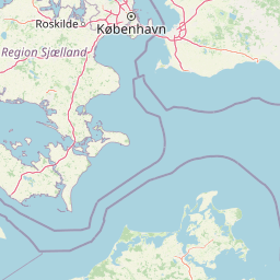
Map view of Staunings Ø

Use this park location map to pinpoint Staunings Ø in Denmark, understand its exact geographic position, and read its mapped placement within the surrounding landscape more clearly.

Pigeon | © OpenStreetMap contributors

Location context for Staunings Ø

Solrød Kommune
Park atlas

Compare adjacent protected landscapes and regional coastal geography across Zealand

Explore Other Parks Near Staunings Ø and Surrounding Coastal Reserves

Continue browsing protected areas near Staunings Ø to examine similar coastal sand spits, dunes, and wetland reserves throughout the region. Expanding the geographic comparison provides broader context on regional habitat succession and coastal landforms.
Nature reserveFaxe Municipality
About 19 km away#1 closest

Southwest

Bagholt Mose: Protected Peatland Mosaic and Fen Geography in Faxe Municipality, Denmark

A high-value Natura 2000 protected wetland and bog habitat.

Bagholt Mose is a significant nature reserve situated within the Munkeskov forest of southern Zealand. The landscape features a distinct combination of historical peat cuttings and raised bog remnants, which together form a rare mosaic of nutrient-poor and calcareous fen communities that support an exceptional diversity of lowland bog flora.

Area
0.17 km²
Established
1985
Relief
Lowland
Scope
Terrestrial
A horizontal watercolor painting depicting a soft, light-filled meadow landscape with scattered trees, low vegetation, and patches of water.
Nature reserveCopenhagen
About 27 km away#2 closest

Northeast

Amager Fælled Nature Reserve: Mapping Copenhagen's Distinctive Protected Landscape

Explore pioneer plant habitats and coastal meadow geography

Amager Fælled functions as a 223-hectare nature reserve that borders the urban development of Copenhagen. The landscape offers a study in contrasts, featuring thin drought-prone soils, historical military and landfill substrates, and protected coastal meadow strips. This site remains a vital geographical reference for understanding urban-edge conservation and the long-term layering of human land use.

Area
2.23 km²
Established
1992
Relief
Lowland
Climate
Temperate
A pale watercolor painting depicting a marshy landscape with rolling green hills, tall grasses in the foreground, and a calm body of water, rendered in soft pastel tones.
Protected areaDenmark
About 30 km away#3 closest

Northeast

Smør- og Fedtmosen: Glacial Tunnel Valley and Protected Mire Geography in Denmark

A key hydrological watershed site and managed meadow reserve

Examine the topographic features of Smør- og Fedtmosen, where groundwater-fed mires and dead-ice depressions create a distinct wetland system. This protected area showcases a transition from saturated reed beds to grazed meadows, illustrating the intersection of long-term conservation and the natural geography of a former tunnel valley.

Area
1.5 km²
Established
1943
Relief
Lowland
Scope
Terrestrial
Nature reserveGentofte Kommune
About 33 km away#4 closest

Northeast

Brobæk Mose Nature Reserve: Protected Wetland and Glacial Geography in Gentofte Kommune

Mapped wetland habitat and natural terrain analysis.

Brobæk Mose serves as a primary example of a spring-fed wetland within the glacial landscapes of Gentofte Kommune. The area preserves rich fens and developing natural forest, offering a clear view of post-glacial valley geography and protected ecological zones surrounded by the Copenhagen suburban environment.

Established
1988
Water
Major water bodies
A watercolor illustration of a soft rolling landscape with green forests, gentle hills in shades of yellow and pink, and a winding waterway.
Protected landscapeDenmark
About 34 km away#5 closest

North

Naturpark Mølleåen: A Protected Glacial Landscape and Tunnel Valley Map in Denmark

Glacial landforms and conserved nature corridors near Copenhagen

Naturpark Mølleåen spans fifty square kilometers of protected forests, lake districts, and ice-margin ridges in northern Zealand. This glacial terrain represents a nationally recognized geological area, offering a rare density of tunnel valleys and meltwater channels that serve as an essential ecological refuge within the broader Danish landscape.

Area
50 km²
Established
1942
Relief
Upland
Climate
Temperate
A watercolor illustration of a serene lakeside landscape with green hills, foliage, and calm water, painted in soft pastel colors.
Protected areaNorth Zealand
About 34 km away#6 closest

North

Furesø Protected Area: Mapping the Deepest Glacial Lake and Wetland Systems of North Zealand

Glacial tunnel valley landscapes and Natura 2000 protected waters.

Spanning deep basins and shallow shorelines, Furesø represents a significant protected freshwater body within the North Zealand region. The surrounding mosaic of peatlands and alder swamps highlights a legacy of glacial activity and ongoing conservation efforts. This area remains a focal point for understanding the interplay between metropolitan geography and preserved natural terrain.

Area
9.41 km²
Relief
Lowland
Climate
Temperate
Access
Easy access
Wildlife reserveDenmark
About 52 km away#7 closest

Southwest

Dybsø Fjord Wildlife Reserve: Coastal Geography and Protected Wetland Map in Denmark

A shallow fjord system on the southwestern coast of Zealand

Dybsø Fjord represents a primary protected landscape in Denmark, featuring a broad and exceptionally shallow lagoon environment. By tracing its boundaries and surrounding peninsulas, users can analyze a critical wetland habitat that supports international bird protection networks and reflects the unique coastal scenery of the Baltic region.

Area
17 km²
Established
1940
Relief
Lowland
Scope
Mixed
A horizontal watercolor painting showing a soft green shoreline in the foreground and rolling hills across the water in the distance.
Nature reserveNaestved Municipality
About 53 km away#8 closest

Southwest

Dybsø Nature Reserve: Protected Coastal Landscape in Naestved Municipality

Geographic atlas of a protected Danish barrier island

Dybsø is a distinct barrier island situated off the coast of Zealand. Its protected landscape consists of open grasslands, coastal reed beds, and freshwater ponds that shelter the shallow waters of the fjord system. As a designated nature reserve, the area represents a critical wildlife refuge, maintained through traditional grazing to preserve its unique maritime terrain and geological history.

Area
1.34 km²
Established
1978
Relief
Lowland
Climate
Temperate

Common questions about visiting, size, designation, and location context for Staunings Ø

Staunings Ø FAQs for park facts, access, geography, and protected area context

Find quick answers about Staunings Ø, including protected-area facts, park geography, trail and visitor context, and how the park fits into its surrounding country and regional landscape.
MoriAtlas Explorer

Continue Your Protected Areas Search Across the Global Atlas

Deepen your exploration by continuing the structured search for national parks and protected areas worldwide. Utilize the comprehensive filtering capabilities to compare different conservation landscapes and refine your understanding of global park geography. Discover more about the distribution and characteristics of protected natural areas.

Global natural geography