
Mori Atlas logo
Nature reserveSüdhang des Thüster Berges

Examining the steep limestone slopes and calcareous grasslands within the Weserbergland range

Südhang des Thüster Berges Nature Reserve: A Detailed Atlas of Protected Landscape and Terrain

Südhang des Thüster Berges serves as a vital protected enclave within Lower Saxony, characterized by sixty hectares of steep, southwest-facing slopes and rare limestone-derived soils. This nature reserve provides a critical study of calcareous semi-dry grassland and dry scrub ecosystems nestled among the broader forested ridges of the Weserbergland. By examining these mapped boundaries and terrain, users gain clear insight into the historical land-use patterns that maintain this open habitat against the backdrop of the surrounding German hill country.

calcareous grasslanddry scrublimestone slopeWeserberglandNaturpark Weserbergland Schaumburg-HamelnLower Saxony
A digital illustration showing a lush mountain valley with a tall waterfall cascading down a cliff face, surrounded by pine forests and a winding river.

Südhang des Thüster Berges

Nature reserve

Park overview

Structured park overview, official facts, and landscape profile for Südhang des Thüster Berges

Südhang des Thüster Berges park facts, protected area profile, and essential visitor context

Review the core facts for Südhang des Thüster Berges, including designation, size, terrain, visitor scale, habitats, and operating context in one park-focused overview.

About Südhang des Thüster Berges

Südhang des Thüster Berges is a compact nature reserve devoted to protecting a single, ecologically valuable hillside in the lower Saxon part of the Weserbergland. The protected site lies on the southern flank of the Thüster Berg, a forested ridge southeast of the town of Salzhemmendorf. Although the wider landscape is dominated by woodland, the reserve focuses on a steep, sun-facing slope where thin, stony soils over weathered limestone create conditions unsuitable for dense forest. In these marginal soils, a community of calcareous semi-dry grassland and dry scrub has established itself, representing a habitat type that has become rare across much of central Europe as traditional land use has changed.

Within the roughly 60-hectare reserve, the open grassland and scrub communities are the main conservation focus, complemented by areas of extensive grassland still in traditional use and patches of near-natural deciduous forest on more stable ground. Together they form a varied hillslope mosaic that supports specialized plants and invertebrates associated with warm, dry, calcareous conditions. The reserve forms part of the larger Naturpark Weserbergland Schaumburg-Hameln, placing it in a regional context of ridges, valleys, and small protected areas that together sustain the characteristic landscape of the Weser Uplands. Its IUCN management category is IV, designating it as a Habitat/Species Management Area.

Quick facts and research context for Südhang des Thüster Berges

Südhang des Thüster Berges is a nature reserve (Naturschutzgebiet) in Lower Saxony, Germany, identified nationally as NSG HA 140 and listed in the World Database on Protected Areas under WDPA ID 165782. It lies in the Hameln-Pyrmont district, southeast of Salzhemmendorf, and falls inside the Naturpark Weserbergland Schaumburg-Hameln. The reserve protects roughly 60 hectares of steep southwest-facing limestone slopes on the Thüster Berg, between approximately 179 and 337 meters above sea level.

Protection and recognition

Terrestrial protected area documentation and administrative recognition details

Südhang des Thüster Berges Protection Status and Designated Area Record

Südhang des Thüster Berges maintains a terrestrial protection framework with documented records in the World Database on Protected Areas. Administrative files consolidate management scope and formal designation data for conservation reference.

Protection details

Protection scope
Terrestrial
Transboundary protection
No
WDPA ID
165782
Park context

Deeper park guide and search-rich context for Südhang des Thüster Berges

Südhang des Thüster Berges history, landscape, wildlife, and travel context

Explore Südhang des Thüster Berges through its history, landscape character, ecosystems, wildlife, conservation priorities, cultural context, and seasonal travel timing in a structured park guide built for atlas discovery and search intent.

Why Südhang des Thüster Berges stands out

The reserve is especially notable for its calcareous semi-dry grasslands (Kalkhalbtrockenrasen) and dry scrub that survive on shallow, limestone-derived soils along a steep, sun-exposed slope. These habitats are relatively rare in the region and have been maintained by historical grazing and mowing practices, giving the protected area a strong open-habitat character uncommon in the surrounding wooded hills of the Weserbergland.
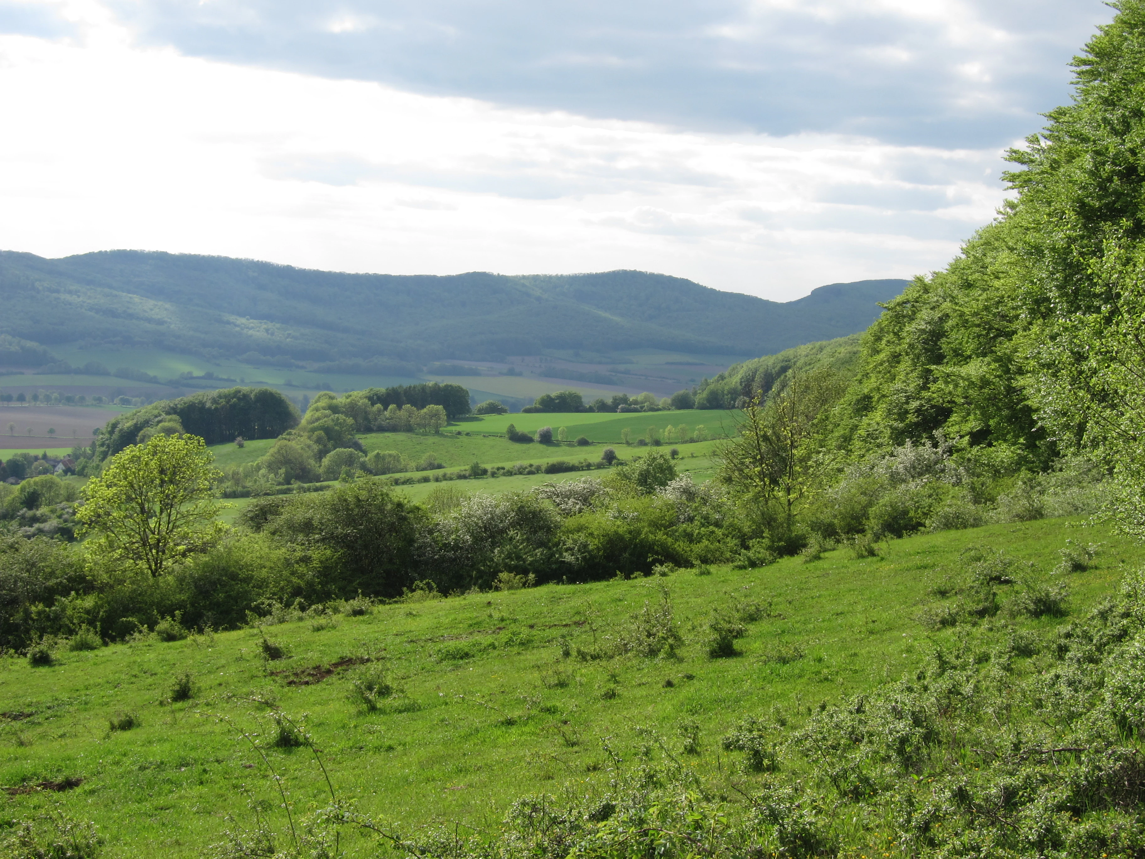
A wide landscape view of grassy hills and meadows in the foreground, with dense forests on the right and a rolling mountain ridge under a cloudy sky in the background.
View across the open meadows and rolling hills of the Thüster Berg nature reserve.

Südhang des Thüster Berges history and protected-area timeline

The Südhang des Thüster Berges was officially placed under nature protection on 10 August 1989, when it was designated as a Naturschutzgebiet with the code NSG HA 140. The designation recognized the scientific and conservation value of the site's calcareous grassland and dry scrub communities, which had developed through long-standing patterns of grazing and low-intensity land use on the steep limestone slope. Lower Saxony's state agency for water management, coastal protection and nature conservation (NLWKN) maintains the formal protection record, while the Landkreis Hameln-Pyrmont acts as the responsible lower nature protection authority for day-to-day oversight.

Südhang des Thüster Berges landscape and geographic character

The reserve occupies the southern slopes of the Thüster Berg, a ridge in the Weserbergland range characterized by alternating wooded hills and valleys. Within the protected area, the terrain is notably steep and southwest-facing, exposing the hillside to strong sunlight throughout the day. Elevations within the reserve range from roughly 179 meters at the lower edge to about 337 meters higher up the slope.

The defining feature of the landscape is the contrast between the steep, open, grassy hillside and the surrounding forested ridges of the Weserbergland. Shallow soils over weathered limestone bedrock restrict tree growth on the slope, producing an unusual open character amid otherwise wooded terrain. The neighboring Ith ridge is visible from the protected hillside, reinforcing the sense of a small natural enclave set within the broader ridgelines of the Weser Uplands.

Südhang des Thüster Berges ecosystems, habitats, and plant life

Ecologically, the site is defined by its calcareous semi-dry grassland (Kalkhalbtrockenrasen) and the dry scrub communities associated with them. These habitats grow on shallow soils derived from limestone weathering, conditions that strongly limit moisture availability and favor drought-adapted plant species. The presence of these grassland communities today is closely tied to historical land use, as they typically depend on grazing or mowing to prevent succession into closed woodland.

Alongside the dry grassland and scrub, the reserve contains extensively managed grassland in the gentler parts of the area and near-natural deciduous forest on more stable soils. This combination of open calcareous habitat, traditionally used grassland, and broadleaf woodland creates a small but ecologically diverse mosaic within a single hillside. The reserve's IUCN Category IV status, Habitat/Species Management Area, reflects an active approach to maintaining the grassland and scrub communities that would otherwise revert to forest.

Südhang des Thüster Berges wildlife and species highlights

While the reserve is small and primarily known for its habitat type rather than for charismatic fauna, the combination of dry, sun-warmed slopes, scrub patches, and nearby woodland supports typical Weserbergland species associated with warm open ground and forest edge. Such mosaics are particularly important for invertebrates adapted to calcareous grassland, including butterflies, bees, and other pollinators that depend on the specialized flora of the dry slopes. The surrounding deciduous forest and the broader Weserbergland landscape provide additional habitat context for typical woodland birds and small mammals of the region.

Südhang des Thüster Berges conservation status and protection priorities

The conservation significance of Südhang des Thüster Berges lies in the preservation of calcareous semi-dry grassland and dry scrub on a steep limestone slope; a habitat type that has become increasingly rare as traditional grazing and mowing have been abandoned across Europe. By protecting both the open habitat and the associated extensive grassland and near-natural deciduous forest, the reserve maintains the ecological processes and habitat mosaic that sustain these specialized communities. Designated under Lower Saxony's nature protection framework and classified as an IUCN Category IV Habitat/Species Management Area, the site reflects a deliberate management-oriented approach to keeping the open habitats open, ensuring that a small but ecologically valuable piece of the Weserbergland's natural heritage is preserved for the long term.

Südhang des Thüster Berges cultural meaning and human context

The reserve's open habitats are a direct cultural artifact, shaped by generations of grazing, mowing, and other low-intensity agricultural practices that prevented woodland from reclaiming the thin, stony soils. These traditional land uses are typical of the Weserbergland and the wider Weser Uplands, where centuries of interaction between rural communities and the hilly landscape have produced a distinctive pattern of forest, grassland, and small protected slopes. The continuation of extensive agricultural management within the reserve is part of preserving this living cultural landscape as well as its ecological value.

Top sights and standout views in Südhang des Thüster Berges

A protected 60-hectare southwest-facing limestone slope in the Weserbergland preserving calcareous semi-dry grassland and dry scrub, complemented by extensive grassland and near-natural deciduous forest, and managed as a Habitat/Species Management Area within the regional nature park landscape of Lower Saxony.

Best time to visit Südhang des Thüster Berges

Late spring through early autumn is generally the most rewarding period to experience the reserve, when the calcareous grasslands and scrub are in active growth and the specialized flora of the dry slopes is most visible. Summer brings warm, dry conditions that highlight why this steep, sun-exposed hillside supports such unusual habitat, while the surrounding forested ridges of the Weserbergland remain appealing for walking at any season. Visitors should keep in mind that this is a protected nature reserve, and any time spent there should focus on quiet observation along the existing paths rather than active recreation.

Monthly climate preview

Long-term representative point measurements for temperature and precipitation rhythms

Südhang des Thüster Berges Climate Normals and Annual Weather by Month

Representative coordinates record measured monthly temperature ranges and daily precipitation patterns across a standard thirty-year climatology period. Detailed twelve-month profiles provide comprehensive numerical records for broader regional climate comparisons.
Annual mean9 °C
0 °C18 °C
Jan
Feb
Mar
Apr
May12°
Jun16°
Jul18°
Aug18°
Sep14°
Oct
Nov
Dec
Warmest month
July

17.8 °C

Coolest month
January

0 °C

Wettest month
July

2.6 mm/day

Driest month
April

1.6 mm/day

Park location guide

Geography guide, regional context, and park location map for Südhang des Thüster Berges

Südhang des Thüster Berges park geography, regions, and map view in Germany

Understand where Südhang des Thüster Berges sits in Germany through a broader geographic reading of the surrounding landscape, nearby location context, and its mapped position within the national park landscape.

How Südhang des Thüster Berges fits into Germany

Germany is a federal republic in Western and Central Europe with a population of over 83 million across sixteen constituent states. It is Europe's largest economy by nominal GDP and a major global exporter and importer. The capital is Berlin, and the country borders Denmark, Poland, Czech Republic, Austria, Switzerland, France, Luxembourg, Belgium, and the Netherlands.

Wider geography shaping Südhang des Thüster Berges in Germany

Germany is located in Western and Central Europe, spanning 357,022 km². It borders Denmark to the north, Poland and the Czech Republic to the east, Austria and Switzerland to the south, and France, Luxembourg, Belgium, and the Netherlands to the west. The country has coastlines on the Baltic Sea and North Sea to the north, with the Alps located in the southern region.

Map view of Südhang des Thüster Berges

Use this park location map to pinpoint Südhang des Thüster Berges in Germany, understand its exact geographic position, and read its mapped placement within the surrounding landscape more clearly.

Pigeon | © OpenStreetMap contributors

Location context for Südhang des Thüster Berges

Lower Saxony

Explore detailed imagery of limestone slopes, open grasslands, and reserve terrain in the Weserbergland

Südhang des Thüster Berges Photos and Landscapes: Visualizing Protected Habitat Scenery

Visual documentation captures the steep southwest-facing limestone slopes, rare calcareous semi-dry grasslands, and dry scrub environments defining Südhang des Thüster Berges. Reviewing these protected area photographs reveals the distinct open-habitat character thriving amid the surrounding forested ridges of Lower Saxony.

A wide landscape view of grassy hills and meadows in the foreground, with dense forests on the right and a rolling mountain ridge under a cloudy sky in the background.

Park atlas

Compare regional limestone slopes and connected protected areas across the Weserbergland.

Exploring Parks Near Südhang des Thüster Berges and Surrounding Protected Landscapes

Browse other parks and protected areas situated near Südhang des Thüster Berges to examine contrasting limestone ridges and valley habitats. Regional park comparison reveals wider ecological patterns across the forested hills and open nature reserves of Lower Saxony.
Watercolor painting of a rolling, forested ridge landscape in shades of green, yellow, and soft pink.
Protected areaLower Saxony
About 2.9 km away#1 closest

West

Ith Protected Area: Mapped Limestone Ridge Geography and Geological Features

Continuous limestone cliff formations in the Lower Saxony uplands

The Ith stands as a major geological landmark in Lower Saxony, featuring a 22 kilometer spine of Upper Jurassic limestone. This protected area preserves a unique collection of cliff crags, dense beech forests, and limestone-dependent plant communities that span the districts of Hameln-Pyrmont and Holzminden.

Relief
Mountain
Climate
Temperate
Access
Access unknown
Scope
Terrestrial
Nature reserveLower Saxony
About 9.9 km away#2 closest

Southwest

Weserniederung am Heiligenberg: Geography and Protected Area Overview

A rare calcareous spring system in Lower Saxony

Weserniederung am Heiligenberg protects a critical mosaic of spring-fed mires, gallery forests, and riverine woodlands in the Weserbergland of Lower Saxony. This nature reserve serves as an important hub for specialized biodiversity, preserving a rare spring horizon and high-quality floodplain forest habitats that provide nesting grounds for eagle owls and black storks.

Area
0.07 km²
Established
2016
Relief
Upland
Climate
Temperate
Natural monumentRheinland-Pfalz
About 13 km away#3 closest

North

Steinbruch Holzmühle Natural Monument: Protected Limestone Landscapes and Geological Map

Mapping the geological strata and amphibian habitats of the Osterwald hills.

Investigate the geological significance and managed ecological profile of Steinbruch Holzmühle. This site features preserved Kimmeridgian limestone formations and restored habitats that provide a unique case study in post-industrial conservation within the local regional hill network.

Nature reserveLower Saxony
About 17 km away#4 closest

North

Zigeunerwäldchen Nature Reserve: A Detailed Geographic Atlas of the Haller River Floodplain

Protected riparian forest boundaries in Lower Saxony

Zigeunerwäldchen is a protected nature reserve in Lower Saxony that preserves a vital fragment of the Haller river floodplain. The landscape is defined by willow-dominated alluvial forest, marshy clearings, and thick stands of sedge. By maintaining these natural water-influenced terrains, the reserve provides a rare glimpse into the historical floodplain architecture of the Calenberger Land region.

Area
0.15 km²
Established
1986
Nature reserveHolzminden
About 20 km away#5 closest

Southwest

Südliche Burgberghänge, Weinberge bei Holenberg und Rühle Nature Reserve and Protected Lands

Geographic atlas and landscape overview in Holzminden

Situated in the Solling foothills, this nature reserve integrates calcareous beech forests and semi-dry grasslands into a singular protected entity. The site highlights complex geological gradients and supports specialized flora and fauna, including rare orchids and woodland birds, within a mosaic of limestone and sandstone terrain near the Bremke brook.

Area
1.77 km²
Established
2020
Relief
Upland
Climate
Temperate
A minimalist watercolor painting featuring soft green, yellow, and purple tones depicting a rolling hill landscape with trees and distant hills.
Nature reserveNiedersachsen
About 21 km away#6 closest

Northeast

Haseder Busch, Giesener Berge, Gallberg, Finkenberg Protected Landscape and Map Data

A diverse hill and floodplain ecosystem in Niedersachsen, Germany.

Trace the ecological boundaries and terrain of this expansive nature reserve. The site features a rare convergence of Triassic sedimentary landscapes, including the northernmost calcareous semi-dry grasslands and beech forests in the region, alongside historic floodplain meadows shaped by the Innerste river.

Area
7.42 km²
Established
2019
A soft watercolor illustration of a river winding through a green floodplain with rolling hills in the background.
Nature reserveRegion Hannover
About 26 km away#7 closest

Northeast

Leineaue zwischen Hannover und Ruthe: Protected Floodplain and River Geography

Nature reserve geography and alluvial habitat mapping.

Examine the topographic and hydrological features of the Leineaue zwischen Hannover und Ruthe nature reserve. This atlas entry provides insights into the site's dual-channel river structure, calcareous tufa springs, and fragmented alluvial woodlands that define this significant conservation area near Hannover.

Area
9.678 km²
Established
2007
Relief
Lowland
Scope
Terrestrial
Nature reserveLower Saxony
About 27 km away#8 closest

East

Steinberg bei Wesseln Nature Reserve: A Protected Limestone Slope in Lower Saxony

Geographic focus on calcareous grassland and ridge topography

Explore the geography of Steinberg bei Wesseln, a nature reserve in the Hildesheim district of Lower Saxony. This protected area features a steep, south-facing Muschelkalk ridge that supports a rich mosaic of semi-dry grassland and scrub. Its unique microclimate makes it a significant site for understanding habitat conservation within the broader landscape of the German hill country.

Area
0.16 km²
Established
2007
IUCN
IV

Common questions about visiting, size, designation, and location context for Südhang des Thüster Berges

Südhang des Thüster Berges FAQs for park facts, access, geography, and protected area context

Find quick answers about Südhang des Thüster Berges, including protected-area facts, park geography, trail and visitor context, and how the park fits into its surrounding country and regional landscape.
MoriAtlas Explorer

Continue Your Protected Areas Search Across the Global Atlas

Deepen your exploration by continuing the structured search for national parks and protected areas worldwide. Utilize the comprehensive filtering capabilities to compare different conservation landscapes and refine your understanding of global park geography. Discover more about the distribution and characteristics of protected natural areas.

Global natural geography