
Mori Atlas logo
Nature reserveSüdlicher Drömling

Understanding the wetland floodplain dynamics and seasonal meadow habitats in Lower Saxony

Südlicher Drömling Nature Reserve: Mapped Protected Landscapes and Alluvial Forest Geography

(Naturschutzgebiet Südlicher Drömling)

The Südlicher Drömling nature reserve encompasses a significant low-lying wetland mosaic along the Aller river in southeastern Lower Saxony. This protected area features a diverse landscape transition from mature alluvial hardwood forests, such as the Allerauenwald, to expansive wet meadows, sedge marshes, and reedbeds. Seasonal flooding processes define the terrain, creating vital habitats for migratory waterfowl and supporting specialized meadow bird communities across the Uhlenhorstwiesen and Kiefholzwiesen complexes.

wetland nature reservefloodplain forestwet meadowsalluvial forestmeadow birdsnature reserve Lower Saxony
A stylized digital illustration of a cascading waterfall flowing into a river surrounded by trees, including birch and green forest, with a soft, pastel-toned environment.

Südlicher Drömling

Nature reserve

Park overview

Structured park overview, official facts, and landscape profile for Südlicher Drömling

Südlicher Drömling park facts, protected area profile, and essential visitor context

Review the core facts for Südlicher Drömling, including designation, size, terrain, visitor scale, habitats, and operating context in one park-focused overview.

About Südlicher Drömling

Südlicher Drömling is a nature reserve in southeastern Lower Saxony, embedded within the broader Drömling lowland, a low-elevation, sparsely populated floodplain region that straddles the Lower Saxony and Saxony-Anhalt border. Although formally designated only in 2018, the reserve draws together landscape elements that have been the focus of conservation management in the region for more than a decade, including the earlier Allerauenwald im Drömling reserve and parts of the surrounding Drömling landscape protection area.

The landscape mosaic is one of the defining features of the site. The western part of the reserve is dominated by forest, ranging from wet alder-ash woodlands and alder swamp forest to hardwood floodplain forest and, on drier ground, luzulo beech woodland. The eastern part opens into broad expanses of species-rich grassland, including hay meadows, wet meadows, and damp tall herb communities, as well as localized reedbeds and sedge marshes. This gradient from forest to open wetland creates a transition zone with high habitat diversity within a relatively compact protected area.

Hydrology shapes the identity of the reserve. The straightened Aller river forms the northwestern boundary, while a network of ditches, many of them bordered by reed and sedge vegetation, drains the grasslands. Winter flooding is a regular occurrence, and its frequency and extent have increased since floodplain restoration measures reconnected portions of the Allerauenwald to the river's natural dynamics. These processes support both the structural richness of the floodplain forest and the seasonal importance of the area for waterbirds.

As part of the wider Drömling, the reserve sits within important Natura 2000 frameworks, including the FFH site "Drömling" and the Birds Directive site "Drömling." Approximately 479 hectares of the reserve fall within the FFH area, and roughly 560 hectares lie within the Birds Directive area, reflecting how strongly the local protection status feeds into broader European nature conservation infrastructure. The combination of meadow conservation, wetland restoration, and natural forest development reflects the layered approach to managing one of northern Germany's most significant inland wetland complexes.

Quick facts and research context for Südlicher Drömling

Südlicher Drömling is a protected nature reserve (Naturschutzgebiet) in the municipalities of Danndorf and Grafhorst in the Samtgemeinde Velpke, within the Landkreis Helmstedt of Lower Saxony, Germany. The reserve covers roughly 602 hectares and lies within the larger Drömling, a sparsely populated lowland wetland complex along the Aller river.

The site is part of the EU Habitats Directive (FFH) area "Drömling" and the EU Birds Directive site "Drömling," and a core section of the Allerauenwald has been designated as a Naturwaldreservat (natural forest reserve). Established on 25 July 2018, it represents one of the more recently formalized protection units within the historically cultivated Drömling landscape, where former drainage and agricultural use has been progressively reversed through extensive rewetting and floodplain restoration.

Protection and recognition

Examine the verified conservation framework and administrative designation history.

Südlicher Drömling Protection Status and International Recognition Data

Südlicher Drömling features documented protection metrics compiled from official global databases and verified registry records. Review the established conservation scope and international designation details for this protected natural landscape.

Protection details

WDPA ID
555690883
Park context

Deeper park guide and search-rich context for Südlicher Drömling

Südlicher Drömling history, landscape, wildlife, and travel context

Explore Südlicher Drömling through its history, landscape character, ecosystems, wildlife, conservation priorities, cultural context, and seasonal travel timing in a structured park guide built for atlas discovery and search intent.

Why Südlicher Drömling stands out

Südlicher Drömling is best known for its combination of wet meadow habitats and species-rich alluvial forest along the Aller river. The reserve contains the Allerauenwald, a floodplain forest in which pedunculate oak and European elm dominate, and which is managed as a natural forest reserve left to develop on its own. The site is also known for its strongly seasonal hydrology. Winter and early spring flooding transforms parts of the area into a major roosting and feeding habitat for migratory waterbirds, while the late spring and summer meadows, especially the Uhlenhorstwiesen and Kiefholzwiesen, support breeding populations of meadow birds that depend on late mowing schedules. Together with the connected FFH and Birds Directive sites of the greater Drömling, it forms one of the more important inland wetland bird regions of northern Germany.
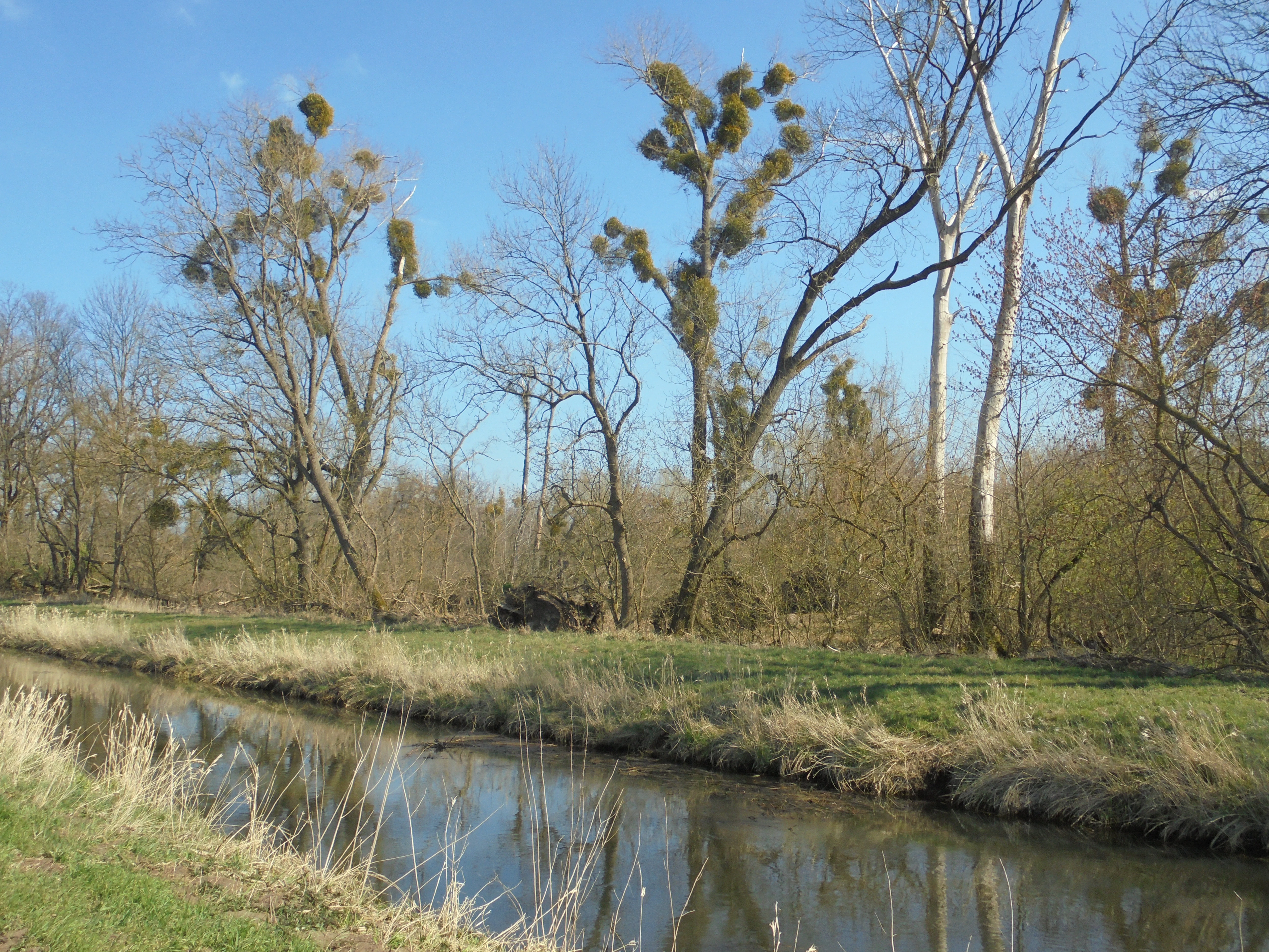
A calm stream flows through a grassy wetland with a riparian forest in the background, featuring bare-branched deciduous trees infested with mistletoe clusters under a clear blue sky.
Alluvial forest along a stream in the Südlicher Drömling nature reserve.

Südlicher Drömling history and protected-area timeline

The Südlicher Drömling was formally established as a nature reserve on 25 July 2018. Its history, however, extends well beyond this formal act of protection.

The Drömling itself has long been considered one of the largest contiguous lowland wetland areas in northern Germany. Like many such landscapes, it was historically drained and converted to agricultural use, with the Aller river straightened to free up land for farming and settlement. Throughout the twentieth century, drainage, peat cutting, and intensification of land use reduced both the area's ecological quality and its hydrological resilience.

From November 2002 to the end of October 2012, the federal-state "Naturschutzgroßprojekt Niedersächsischer Drömling" (large-scale conservation project of the Lower Saxon Drömling) was implemented to reverse these trends. The project focused on restoring and securing wet grasslands, reactivating floodplain dynamics along the Aller, and supporting the maintenance of habitats such as the Allerauenwald. In 2008, portions of the Aller river embankment were partially removed to reconnect the floodplain forest with the river.

In 2011, around 99 hectares of the Allerauenwald were designated as a Naturwaldreservat, a natural forest reserve left to develop without forestry intervention. When the Südlicher Drömling reserve was created in 2018, it absorbed both the earlier 94.7-hectare Allerauenwald im Drömling reserve and parts of the surrounding Drömling landscape protection area, consolidating these efforts into a single, larger protection unit managed by the Landkreis Helmstedt as the responsible lower nature conservation authority.

Südlicher Drömling landscape and geographic character

The Südlicher Drömling occupies part of a flat, low-lying wetland landscape at roughly 56 to 58 meters above sea level. The terrain is subtle, defined less by dramatic relief than by shifting transitions between forest, meadow, marsh, and open water. The reserve is bounded in the northwest by the straightened course of the Aller river, whose embankments and former dams have shaped the surrounding floodplain for generations.

In the western and southwestern portions of the reserve, woodland dominates. The floodplain character of these forests is unmistakable: alder-ash woodlands, alder swamp forests, and hardwood floodplain forests occupy the wetter ground closest to the Aller, while patches of oak-hornbeam forest appear on slightly higher, less waterlogged soils. On the driest sites, remnants of luzulo beech woodland persist. The Allerauenwald in the south of the reserve is the forest core, with a noticeable share of old trees and a well-developed shrub layer, and it has been deliberately left to develop without active forestry.

The eastern half of the reserve opens up into broad meadowland. Species-rich hay meadows occupy the drier grassland sites, while wet meadows, damp tall herb communities, sedge marshes, and reed stands are concentrated in the lowest-lying areas. The Uhlenhorstwiesen in the southwest and the Kiefholzwiesen in the northeast are especially notable grassland complexes, dissected by numerous ditches that retain water through much of the year and create valuable edge habitats for amphibians, invertebrates, and wetland birds.

Seasonal flooding is a defining landscape process. During the winter half-year, water levels rise across the meadows and along the Aller floodplain, periodically transforming much of the reserve into shallow open water and saturated grassland. These temporary inundations are central to the area's ecological value, particularly for migrating waterfowl and waders. Small remnants of arable land remain in the east, but the dominant impression is of a wetland landscape caught between active restoration and the older mosaic of forest, meadow, and floodplain.

Südlicher Drömling ecosystems, habitats, and plant life

The ecological profile of the Südlicher Drömling centers on a tight interplay between alluvial forest, wet grassland, marsh vegetation, and aquatic habitats.

The floodplain forests along the Aller are among the most ecologically distinctive elements of the reserve. They include hardwood floodplain forest rich in pedunculate oak and European elm, alongside softwood alluvial forests dominated by common alder and ash, with willow species along more dynamic waterside edges. Where ground conditions are wetter and less dynamic, alder swamp forest and sedge-dominated woodland take over. Oak-hornbeam woodland occupies intermediate, slightly higher elevation sites, while drier patches support acid-tolerant beech woodland communities. The Allerauenwald is notable both for its structure and for its management regime as a natural forest reserve.

The grasslands are similarly varied. Species-rich hay meadows, wet meadows, damp tall-herb fringes, sedge stands, and reedbeds each contribute different vegetation structures. These habitats are managed extensively, with late mowing dates applied to meadows such as the Uhlenhorstwiesen and Kiefholzwiesen specifically to protect ground-nesting meadow birds. Small remnants of arable land persist in the eastern part of the reserve, providing additional habitat heterogeneity.

A dense network of ditches runs through the meadows, supporting aquatic and semi-aquatic vegetation and serving as important habitat for amphibians, dragonflies, and fish. The Aller river itself and its connected waters harbor fish species such as the European weatherfish and the bitterling, along with populations of large mussels. Amphibians are well represented in the wetter habitats and ditches, including species such as the northern crested newt, European tree frog, moor frog, natterjack toad, and garlic toad.

Together, these habitats form a transitional mosaic that supports both resident and migratory wildlife and reflects the active rewetting and floodplain restoration that has shaped the reserve over the past two decades.

Südlicher Drömling wildlife and species highlights

The Südlicher Drömling hosts a particularly rich bird community, owing to the combination of mature floodplain forest, open wet grassland, and seasonally inundated meadows. The reserve is home to species such as the black stork, common crane, black kite, red kite, marsh harrier, honey buzzard, hobby, and corncrake. Among ground-nesting meadow birds, the Eurasian curlew, common snipe, northern lapwing, and Eurasian woodcock are notable, alongside wet grassland specialists like the spotted crake, water rail, garganey, and various duck species.

Woodland birds are well represented in the floodplain and oak-hornbeam forests. Black, grey, and middle spotted woodpeckers find suitable habitat in the older trees of the Allerauenwald, while species such as the Eurasian hobby, common quail, red-backed shrike, Eurasian golden oriole, common nightingale, whinchat, common redstart, sedge warbler, and Savi's warbler occur across the various habitat transitions.

The area is also important for waterbirds during migration and winter. Seasonal flooding expands the available aquatic and wet habitat, attracting flocks of ducks, geese, and waders that use the flooded meadows as roosting and feeding grounds. White storks regularly forage in the open grasslands during the breeding season.

Mammals include the Eurasian otter and the European beaver, both of which are linked to the wetter aquatic habitats and ditches of the Drömling. Amphibians are well represented, particularly in the ditch network and wet meadows, with breeding populations of northern crested newt, European tree frog, moor frog, natterjack toad, and garlic toad. Fish fauna of the Aller and its connected watercourses includes species such as the European weatherfish and bitterling, while populations of large freshwater mussels contribute to the broader aquatic biodiversity of the area.

Südlicher Drömling conservation status and protection priorities

Südlicher Drömling is one of the most important inland wetland conservation units in southeastern Lower Saxony and forms a critical component of the larger Drömling protected area network that spans the Lower Saxony and Saxony-Anhalt border. Almost the entire reserve lies within both the FFH site "Drömling" (roughly 479 hectares) and the EU Birds Directive site "Drömling" (roughly 560 hectares), linking it directly to the European Natura 2000 network.

The conservation significance of the area is rooted in the active restoration of natural floodplain processes. Through the Naturschutzgroßprojekt Niedersächsischer Drömling, substantial portions of the historic agricultural landscape of the Drömling were rewetted, and segments of the Aller river embankment were removed in 2008 to reconnect the Allerauenwald to the river's natural dynamics. These interventions allow seasonal flooding to spread across the floodplain once again, supporting both the structural development of alluvial forest and the seasonal habitat availability for waterbirds.

A further layer of conservation value lies in the legal protection of the Allerauenwald as a natural forest reserve. By setting aside almost 100 hectares of floodplain forest from active forestry, the reserve allows natural successional processes, deadwood accumulation, and the development of older age-class structures that are rare in heavily managed lowland forests. The reserve's role for meadow-breeding birds is reinforced through targeted mowing restrictions on the Uhlenhorstwiesen and Kiefholzwiesen, which delay mowing until after 1 June to avoid the core breeding season of vulnerable ground-nesting species.

Südlicher Drömling cultural meaning and human context

The Drömling has a long cultural history as a wetland frontier between settlements. For centuries, communities around the Drömling wrestled with its persistent water, gradually draining and converting parts of the marshland for agriculture, peat cutting, and settlement. The straightening of the Aller and the construction of drainage channels transformed both the landscape and the local economy, although the area has remained relatively sparsely populated compared to surrounding regions of Lower Saxony.

In the early twenty-first century, this long history of drainage was deliberately partly reversed through large-scale conservation investment. The shift from cultivation to wetland restoration reflects a broader re-evaluation of the Drömling's role, from a landscape to be tamed into productive farmland to one valued primarily for its ecological functions, biodiversity, and natural flood dynamics.

The reserve itself straddles this transition. Land use in the area remains a blend of extensive grassland management, protected forest development, and small remnants of arable farming, supporting a landscape where traditional rural land use patterns coexist with contemporary conservation priorities. The bordering districts of Wolfsburg and the Landkreis Helmstedt, as well as the nearby communities of Danndorf, Grafhorst, and Rühen, form the immediate human backdrop against which the reserve is situated.

Top sights and standout views in Südlicher Drömling

The reserve's principal highlight is the Allerauenwald, a mature alluvial forest along the Aller river that includes a designated natural forest reserve where natural processes, including seasonal flooding and old-growth development, are allowed to unfold without forestry intervention.

A second standout feature is the reserve's seasonal hydrology: during the winter half-year, regular flooding converts substantial portions of the grassland and floodplain into open water, transforming the area into a regionally important staging and wintering site for waterfowl and waders.

The mosaic of species-rich wet meadows, sedge marshes, reedbeds, and ditches across the eastern grasslands provides one of the most important meadow-breeding bird habitats in the region. The late mowing regime on the Uhlenhorstwiesen and Kiefholzwiesen directly supports species such as the Eurasian curlew, northern lapwing, common snipe, and corncrake.

Best time to visit Südlicher Drömling

Late spring and early summer offer the most balanced experience of the reserve, when water levels are typically lower, the meadows are green and rich in flowering plants, and both forest and meadow birds are actively breeding. The late-mown Uhlenhorstwiesen and Kiefholzwiesen retain their meadow character into midsummer, supporting both breeding birds and a rich invertebrate community.

Autumn brings its own character, with quieter conditions, seasonal bird migration, and the gradual return of wetter conditions. Winter is when the reserve undergoes its most dramatic transformation, as regular flooding across the meadows and floodplain attracts large numbers of waterfowl and waders. Visiting during this season offers an exceptionally vivid wetland experience, although access may be restricted by high water levels.

Monthly climate preview

Long-term representative averages of monthly temperature and precipitation rhythm

Südlicher Drömling Climate Normals and Annual Temperature Patterns

Südlicher Drömling exhibits measured monthly temperature variations alongside stable precipitation averages across a representative coordinate elevation of 80.44 meters. Examining the complete twelve-month climate profile reveals comprehensive long-term data for regional analysis.
Annual mean9 °C
0 °C19 °C
Jan
Feb
Mar
Apr
May13°
Jun17°
Jul19°
Aug18°
Sep14°
Oct
Nov
Dec
Warmest month
July

18.6 °C

Coolest month
January

0.2 °C

Wettest month
July

2.6 mm/day

Driest month
April

1.4 mm/day

Park location guide

Geography guide, regional context, and park location map for Südlicher Drömling

Südlicher Drömling park geography, regions, and map view in Germany

Understand where Südlicher Drömling sits in Germany through a broader geographic reading of the surrounding landscape, nearby location context, and its mapped position within the national park landscape.

How Südlicher Drömling fits into Germany

Germany is a federal republic in Western and Central Europe with a population of over 83 million across sixteen constituent states. It is Europe's largest economy by nominal GDP and a major global exporter and importer. The capital is Berlin, and the country borders Denmark, Poland, Czech Republic, Austria, Switzerland, France, Luxembourg, Belgium, and the Netherlands.

Wider geography shaping Südlicher Drömling in Germany

Germany is located in Western and Central Europe, spanning 357,022 km². It borders Denmark to the north, Poland and the Czech Republic to the east, Austria and Switzerland to the south, and France, Luxembourg, Belgium, and the Netherlands to the west. The country has coastlines on the Baltic Sea and North Sea to the north, with the Alps located in the southern region.

Map view of Südlicher Drömling

Use this park location map to pinpoint Südlicher Drömling in Germany, understand its exact geographic position, and read its mapped placement within the surrounding landscape more clearly.

Pigeon | © OpenStreetMap contributors

Location context for Südlicher Drömling

Landkreis HelmstedtNiedersachsen

Explore protected area views, alluvial forests, and seasonal floodplain habitats.

Visualizing Südlicher Drömling: Landscape Photography and Wetland Scenery

Photographic documentation of Südlicher Drömling reveals the subtle terrain, wet meadows, and mature alluvial forests that define the Aller river basin. Examining these protected habitats clarifies the complex hydrology and environmental character of the lowland nature reserve.

A calm stream flows through a grassy wetland with a riparian forest in the background, featuring bare-branched deciduous trees infested with mistletoe clusters under a clear blue sky.

Park atlas

Compare surrounding wetland reserves, floodplain forests, and regional conservation areas.

Parks Near Südlicher Drömling and Other Protected Landscapes to Explore Next

Continue exploring other protected areas and wetland reserves located near Südlicher Drömling. Examining these adjacent lowland ecosystems and river floodplains provides broader regional context for northern German conservation landscapes.
Nature reserveNiedersachsen
About 3.4 km away#1 closest

West

Wendschotter und Vorsfelder Drömling mit Kötherwiesen: Protected Peatlands and Floodplains

Niedersachsen lowland geography and wetland habitat mapping

Spanning over 700 hectares in Wolfsburg, this nature reserve protects a complex network of marshes, reedbeds, and alluvial meadows. This atlas-focused overview examines the reserve's historic ditch systems, river corridors, and its role as a core component of the regional Drömling ecological network.

Area
7.22 km²
Established
2020
Relief
Lowland
Climate
Temperate
Nature reserveLower Saxony
About 13 km away#2 closest

Northwest

Vogelmoor Nature Reserve: Geographic Map and Protected Wetland Landscape in Lower Saxony

Birch bog forests, peat ponds, and rare mire habitats

Vogelmoor offers a deep look into the glacial topography of northern Germany. As a core protected area within the Gifhorn district, this site features a diverse assembly of sphagnum-rich forest, floating mats, and open heath. The reserve stands as a critical example of landscape restoration within a heavily agricultural region, providing essential refuge for wetland bird species and specialized bog vegetation.

Area
1.335 km²
Established
1974
IUCN
IV
Watercolor illustration of a peaceful landscape featuring distant rolling hills, clusters of trees on the right, and a river or stream winding through a grassy plain against a pale background.
Protected landscapeLower Saxony
About 19 km away#3 closest

South

Dorm Protected Landscape: Geological Ridge and Forested Geography in Lower Saxony

Mapping the natural terrain and forest ecosystems of the East Brunswick hill country

Defined by its narrow anticline structure and diverse woodland mosaics, the Dorm stands as a vital protected area in Lower Saxony. This overview examines the ridge's geological composition, including its Triassic sandstone formations, saline habitats, and significant doline pools that characterize this prominent East Brunswick landmark.

Area
6.89 km²
Established
2020
Relief
Upland
Climate
Temperate
Protected landscapeLower Saxony
About 29 km away#4 closest

Southwest

Weddeler Teich Protected Landscape: Wetland Geography and Regional Map Context

A mapped nature reserve in the Lower Saxony lowlands

Weddeler Teich is a protected landscape in Lower Saxony characterized by its shallow, nutrient-rich basin and extensive reed vegetation. This wetland reserve acts as a critical refuge for bird species, standing out as a verdant marshy pocket within the wider cultivated agricultural plains east of Braunschweig.

Area
0.2 km²
Established
1981
Relief
Lowland
Climate
Temperate
Nature reserveLower Saxony
About 31 km away#5 closest

West

Viehmoor Nature Reserve: A Detailed Atlas of Wetland and Dune Landscapes in Lower Saxony

Protected lowlands, inland dunes, and riparian habitats

Viehmoor is a distinct 302-hectare protected area in Lower Saxony defined by its glacial history and diverse habitat transitions. The site features an inland dune ridge encircling a groundwater-fed lowland mire, alongside varied aquatic environments including reed-fringed fishponds and peat-cutting pools that provide vital breeding grounds for regional bird populations.

Area
3.02 km²
Established
1979
IUCN
IV
Nature reserveLower Saxony
About 44 km away#6 closest

North

Zwergbirkenmoor bei Schafwedel: Protected Bog and Birch Woodland Geography

A rare peatland remnant in the Lower Saxony moorland network.

Zwergbirkenmoor bei Schafwedel is a designated nature reserve that safeguards a small but ecologically significant raised bog remnant. Set amidst the unique salt-dome subsidence landscape of the Lüneburg Heath, the reserve serves as a critical site for studying rare northern birch bog communities and the interaction between groundwater systems and post-salt-dome terrain.

Area
0.027 km²
Established
1950
IUCN
IV
Relief
Lowland
Nature reserveLower Saxony
About 48 km away#7 closest

West

Wendesser Moor Nature Reserve: Mapped Wetland Geography and Protected Landscape Context in Lower Saxony

Exploring the peatland mosaic and marsh bird habitats of the Peine district

Wendesser Moor is a significant 63-hectare nature reserve in Lower Saxony, defined by its rare concentration of fen habitats, alder carr, and open peat pools. As a core component of a wider landscape protection zone, it provides essential refuge for threatened bird species. The reserve functions as a critical node in the local watershed, illustrating how small-scale protected peatlands maintain biodiversity in agricultural lowlands.

Area
0.632 km²
Established
1973
IUCN
IV
Relief
Lowland
Nature reserveSalzgitter
About 56 km away#8 closest

Southwest

Tagebau Haverlahwiese Nature Reserve: Geography and Protected Area Mapping in Salzgitter

Mapping restored post-industrial landscapes and habitat mosaics.

This protected area in Salzgitter showcases the natural recovery of former ironstone mining lands. Users can examine the spatial arrangement of the 15-hectare mining lake, extensive reedbeds, and dry calcareous grassland slopes. The site remains a vital example of landscape conservation, illustrating how engineered topography provides new niches for amphibians and salt-tolerant plant communities across the Lichtenberge ridge.

Area
2.06 km²
Established
2016
Relief
Upland
Climate
Temperate

Common questions about visiting, size, designation, and location context for Südlicher Drömling

Südlicher Drömling FAQs for park facts, access, geography, and protected area context

Find quick answers about Südlicher Drömling, including protected-area facts, park geography, trail and visitor context, and how the park fits into its surrounding country and regional landscape.
MoriAtlas Explorer

Continue Your Protected Areas Search Across the Global Atlas

Deepen your exploration by continuing the structured search for national parks and protected areas worldwide. Utilize the comprehensive filtering capabilities to compare different conservation landscapes and refine your understanding of global park geography. Discover more about the distribution and characteristics of protected natural areas.

Global natural geography