Mori Atlas logo
Wildlife reserveSurinsar-Mansar Lakes

A paired wetland complex and forested foothill habitat located in the Jammu region of India.

Surinsar-Mansar Lakes Wildlife Reserve: Mapped Protected Landscapes and Regional Geography

Surinsar-Mansar Lakes represent a significant wetland complex situated within the forested foothills of India. This wildlife reserve serves as a critical habitat for migratory waterfowl and native freshwater turtles, while its geography encompasses a mosaic of scrub woodland, pine-fringed basins, and ancient cultural sites. The area offers a distinct look into the transitional terrain between the northern plains and the sub-Himalayan zone.

wetlandRamsar sitelakesmigratory birdsfreshwater turtlesHindu pilgrimage

Surinsar-Mansar Lakes

Wildlife reserve

Park overview

Structured park overview, official facts, and landscape profile for Surinsar-Mansar Lakes

Surinsar-Mansar Lakes park facts, protected area profile, and essential visitor context

Review the core facts for Surinsar-Mansar Lakes, including designation, size, terrain, visitor scale, habitats, and operating context in one park-focused overview.

About Surinsar-Mansar Lakes

Surinsar-Mansar Lakes is a paired wetland system situated on the lower foothills near Jammu, in the Samba district of the union territory of Jammu and Kashmir. The two lakes, separated by some distance but joined in name, geography, and legend, occupy a transitional zone between the flat agricultural plains approaching the Punjab and the forested, scrub-covered hills that climb toward the middle Himalayas. Together they form one of the more recognizable natural and cultural landmarks of the Jammu region.

The larger of the two, Mansar Lake, stretches over roughly a mile in length and is fringed by forested ridges of pine, peepal, acacia, and scrub growth. Its dark-green waters, set against the gentle wooded hills, give the lake a quiet, enclosed character that has supported centuries of religious activity. Surinsar, the smaller of the two water bodies, lies closer to Jammu along a bypass route and complements Mansar hydrologically and ecologically. The lakes are fed largely by surface runoff and rainwater percolating through paddy fields, with a partial mineralized inflow that shapes their chemical character and underpins their productivity as habitat.

Beyond their scenic setting, the lakes have gained international standing through their designation as a Ramsar Wetland in November 2005. They function as breeding grounds, nurseries, and wintering sites for migratory waterfowl such as coots, moorhens, black-necked grebes, tufted ducks, and several Anas species. The nutrient-rich bed of the lake supports rich invertebrate life, including the microcrustacean Mansariella lacustris, and sustains native freshwater turtles such as Lissemys punctuata and Aspideretes gangeticus, both recognized under IUCN and CITES as species of conservation concern. The surrounding forests and a nearby wildlife sanctuary extend the protected landscape, offering refuge to spotted deer, nilgai, cranes, and a variety of resident and migratory birdlife. As a result, Surinsar-Mansar Lakes combines ecological significance, scenic beauty, religious heritage, and accessible regional tourism in a single, compact setting just a short drive from Jammu city.

Quick facts and research context for Surinsar-Mansar Lakes

Surinsar-Mansar Lakes is a paired wetland system in the Samba district of Jammu and Kashmir, set among low forested hills on the edge of the Jammu plains. Mansar Lake, the larger of the two, is about 62 km from Jammu city and roughly 19 km from Samba, while the smaller Surinsar Lake lies nearer to Jammu along a bypass route. The two lakes together were designated as a Ramsar Wetland of International Importance in November 2005.

The surrounding forests host a mix of scrub, pine, peepal, and acacia, and the lakes themselves are an important wintering and breeding ground for migratory waterfowl including coots, moorhens, grebes, and several duck species. The nutrient-rich waters support freshwater turtles noted on the IUCN Red List, and the broader area includes a wildlife sanctuary that harbors spotted deer, nilgai, cranes, and other native fauna.

Protection and recognition

Documented designation history and official international wetland recognition records

Surinsar-Mansar Lakes Protection Status and International Ramsar Recognition

Surinsar-Mansar Lakes holds documented protection status stemming from its 2005 designation as a recognized wetland of international importance. Official records outline the governing designation history and international recognition sources for this protected landscape.

International recognition

Protection details

Designated year
2005
Park context

Deeper park guide and search-rich context for Surinsar-Mansar Lakes

Surinsar-Mansar Lakes history, landscape, wildlife, and travel context

Explore Surinsar-Mansar Lakes through its history, landscape character, ecosystems, wildlife, conservation priorities, cultural context, and seasonal travel timing in a structured park guide built for atlas discovery and search intent.

Why Surinsar-Mansar Lakes stands out

Surinsar-Mansar Lakes is best known as a paired sacred wetland complex on the fringe of the Jammu lowlands, recognized internationally for its importance to migratory waterfowl and freshwater turtle species. The two lakes, framed by forested hills, also carry strong Hindu religious associations and are linked by a legendary Mahabharata-era narrative involving Arjuna and Babruvahana. The lakes stand out because their ecological and cultural layers intersect. They serve as breeding and nursery habitat for migratory ducks and coots while also functioning as a pilgrimage site where devotees perform ritual circumambulations. The combination of Ramsar recognition, reptile-specific conservation value, and enduring sacred traditions gives the site a distinctive identity among India's protected wetlands.
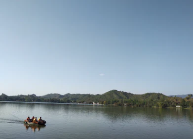
A small boat with passengers moving across the surface of a large lake with rolling green hills in the background under a clear sky.
Visitors enjoying a boat ride on the calm waters of Mansar Lake.

Surinsar-Mansar Lakes history and protected-area timeline

The cultural and legendary history of Surinsar-Mansar Lakes is closely tied to the Mahabharata. Local tradition holds that Babruvahana, son of Arjuna and the serpent-queen Ulupi, ruled this territory. After the great war, Arjuna conducted the ashvamedha yajna to reassert his authority; when the ceremonial horse was intercepted near present-day Udhampur, the conflict led to Arjuna's death at Babruvahana's hands. The narrative continues with Babruvahana's quest to revive his father through a jewel from Shesha, the serpent deity, after which the lakes emerged as part of this mythic landscape. Surinsar's name, drawn from "Surangsar," refers to the legendary subterranean passage that Babruvahana is said to have created.

In the modern era, the defining institutional moment in the lakes' history came on 8 November 2005, when Surinsar-Mansar Lakes were formally designated as a Ramsar Wetland of International Importance. This recognition elevated the site's profile beyond its regional pilgrimage and ecological identity, placing the lakes among India's recognized international wetlands and anchoring their importance for migratory waterfowl and freshwater biodiversity in formal conservation policy.

Surinsar-Mansar Lakes landscape and geographic character

The landscape of Surinsar-Mansar Lakes reflects the transitional geography between the northern Indian plains and the sub-Himalayan foothill zone. Mansar Lake sits in a shallow basin surrounded by low, forest-covered hills, with pine trees lining parts of its shoreline alongside mixed deciduous growth such as peepal and acacia. The encircling woodland creates a green amphitheatre around the water, giving the lake a calm, sheltered feel that contrasts with the broader open agricultural lowlands beyond the hills.

Surinsar, the smaller companion lake, shares this hill-fringed character on a more compact scale and lies closer to Jammu. Together, the two lakes sit within a mosaic of scrub woodland, patches of denser pine forest, terraced agriculture, and seasonal paddy fields whose runoff contributes to the lakes' hydrology. The terrain rolls gently rather than rising sharply, with the highest visual drama coming from the contrast between the dark water surface and the layered green of the surrounding ridges. The setting is scenic without being rugged, an accessible lowland-to-foothill landscape typical of this part of Jammu.
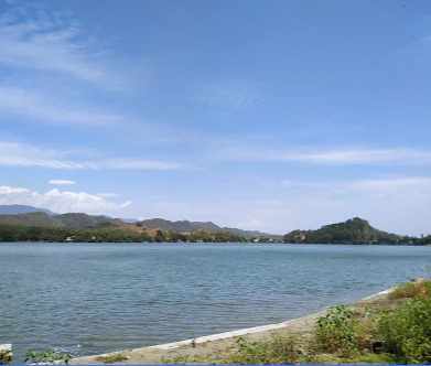
A wide, eye-level shot of a large lake with calm blue water, surrounded by rolling hills under a bright blue sky with scattered clouds.
A scenic afternoon view of Mansar Lake.

Surinsar-Mansar Lakes ecosystems, habitats, and plant life

Ecologically, Surinsar-Mansar Lakes represents a nutrient-rich lowland freshwater system embedded in a forest mosaic. The lake floors hold high concentrations of micronutrients derived from organic input and mineralized inflow from surrounding paddy fields, creating conditions that are unusually productive for plankton, invertebrates, fish, and reptiles. This biological richness is what underpins the lakes' value as avian habitat and as a refuge for native freshwater biodiversity.

The catchment forests around the lakes include scrub vegetation, mixed deciduous trees, and pine stands, producing a layered habitat that supports both aquatic and terrestrial species. The water body, the shoreline vegetation, and the wooded slopes together function as a connected ecological unit, with the lake providing food and shelter for resident and migratory species, while the surrounding woodlands offer cover, nesting habitat, and safe browsing for mammals such as spotted deer and nilgai. This kind of land-water-forest linkage is a defining feature of the site's natural character.
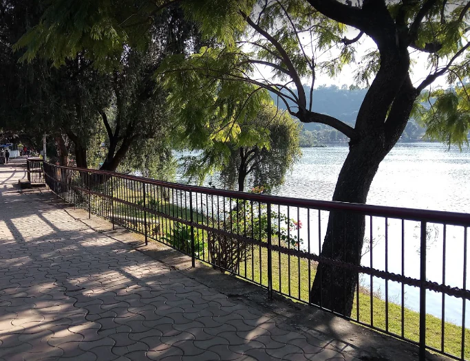
A paved walkway with a metal railing along the edge of a lake, shadowed by trees on a bright day.
A paved footpath bordering the shoreline of Mansar Lake.

Surinsar-Mansar Lakes conservation status and protection priorities

Surinsar-Mansar Lakes received formal recognition under the Ramsar Convention in November 2005, acknowledging their international significance as a wetland of conservation value. This designation reflects the lakes' role in supporting migratory waterfowl species, including coots, moorhens, grebes, and various ducks, and their function as breeding, nursery, and resting habitat.

The wetland also carries important value for freshwater biodiversity. It supports reptile species such as Lissemys punctuata and Aspideretes gangeticus, turtles that appear on the IUCN Red List and are listed in CITES appendices, alongside the microcrustacean Mansariella lacustris. The muddy lake floor is rich in micronutrients, which sustains the food web that these migratory and resident species depend on. Surrounding forest cover and a nearby wildlife sanctuary further extend the conservation landscape, providing refuge for deer, nilgai, and a range of birds and reptiles.

Surinsar-Mansar Lakes cultural meaning and human context

The lakes are deeply woven into local Hindu religious life and legend. Mansar shares its sanctity and folklore with the far more famous Lake Manasarovar in Tibet, and devotees come to its shores for ritual bathing, especially during festivals. A prominent shrine to Shesha, the serpent mount of Vishnu, stands on the eastern bank; iron chains placed on a boulder near the shrine are interpreted as symbolic representations of attendant serpents.

Ancient temples dedicated to Shiva, Narasimha, and Durga sit close to the lakeshore, drawing regular pilgrim traffic. Newlyweds traditionally perform three circumambulations parikrama of the lake to seek the serpent lord's blessings, and certain Hindu communities carry out the mundana, the first haircut ceremony for male children, at this site. A local tradition, rooted in the Mahabharata, ties the lakes directly to the story of Arjuna, Babruvahana, and Ulupi, adding a mythological layer that links Surinsar and Mansar through the legendary "Surangsar" passage.

Top sights and standout views in Surinsar-Mansar Lakes

The most striking highlights of Surinsar-Mansar Lakes include the forested, hill-fringed setting of the two water bodies, the presence of ancient Shiva, Narasimha, and Durga temples on the shores, and the shrine to Shesha on the eastern bank of Mansar. The Ramsar designation itself is a key marker of the site's environmental significance, while the surrounding wildlife sanctuary adds an extra layer of natural interest.

The lakes also stand out for the unusual combination of sacred geography and ecological value they represent. Devotees performing ritual circumambulations share the shoreline with migratory waterfowl and native turtles, and the broader region around Mansar offers boating, forest walks, and connection to the Jammu-Pathankot-Udhampur road network, making the lakes both a cultural landmark and an accessible natural retreat.

Best time to visit Surinsar-Mansar Lakes

Winter is widely considered the most rewarding season to experience the lakes, when migratory waterfowl such as coots, moorhens, grebes, and several duck species arrive to use the water body as a wintering and resting ground. Cooler conditions also make walks along the lake shores and visits to the lakeside temples more comfortable.

Spring and early summer bring greener surroundings as the forested hills revive, though the waterbird spectacle diminishes as migrants begin to depart. Heavy monsoon months can make the area lush but also humidity-heavy, and the broader region experiences cool winters and warm to hot summers overall. Travelers interested in both the birdlife and the lake-side pilgrimage atmosphere will generally find the cooler months the most rewarding window.

Monthly climate preview

Long-term representative temperature and precipitation patterns across twelve months

Surinsar-Mansar Lakes Climate Normals and Annual Weather Rhythm

Representative coordinates record mean monthly temperatures spanning from 12.46 degrees Celsius to 34.41 degrees Celsius alongside daily precipitation rates peaking during mid-year months. Examining the complete monthly climate profile provides detailed historical baseline data for this protected area.
Annual mean24 °C
12 °C34 °C
Jan12°
Feb15°
Mar20°
Apr26°
May32°
Jun34°
Jul32°
Aug30°
Sep28°
Oct24°
Nov19°
Dec15°
Warmest month
June

34.4 °C

Coolest month
January

12.5 °C

Wettest month
July

7 mm/day

Driest month
November

0.4 mm/day

Park location guide

Geography guide, regional context, and park location map for Surinsar-Mansar Lakes

Surinsar-Mansar Lakes park geography, regions, and map view in India

Understand where Surinsar-Mansar Lakes sits in India through a broader geographic reading of the surrounding landscape, nearby location context, and its mapped position within the national park landscape.

How Surinsar-Mansar Lakes fits into India

India is a South Asian country bordered by the Indian Ocean, Arabian Sea, and Bay of Bengal. It shares land borders with Pakistan, China, Nepal, Bhutan, Bangladesh, and Myanmar. The country has a population of over 1.4 billion people and operates as a federal parliamentary republic with its capital in New Delhi.

Wider geography shaping Surinsar-Mansar Lakes in India

India occupies the Indian subcontinent in South Asia, bordered by the Arabian Sea to the southwest, the Bay of Bengal to the southeast, and the Indian Ocean to the south. It shares land borders with Pakistan to the west, China, Nepal, and Bhutan to the north, and Bangladesh and Myanmar to the east. The territory also includes the Andaman and Nicobar Islands in the Indian Ocean.

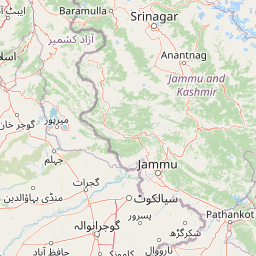
Map view of Surinsar-Mansar Lakes

Use this park location map to pinpoint Surinsar-Mansar Lakes in India, understand its exact geographic position, and read its mapped placement within the surrounding landscape more clearly.

Pigeon | © OpenStreetMap contributors

Visual reference for the paired wetland landscape, foothill terrain, and wildlife habitats.

Surinsar-Mansar Lakes Photos and Protected Area Scenery

Examine detailed imagery of Surinsar-Mansar Lakes to understand the forested hill topography, wetland habitats, and protected environmental character of the region. Visual records reveal the distinct transition zones between the northern plains and the sub-Himalayan ridges.

A small boat with passengers moving across the surface of a large lake with rolling green hills in the background under a clear sky.

A flock of white geese standing and grazing on the grassy bank near the edge of a calm lake, with forested hills in the background.

A wide, eye-level shot of a large lake with calm blue water, surrounded by rolling hills under a bright blue sky with scattered clouds.

A paved walkway with a metal railing along the edge of a lake, shadowed by trees on a bright day.

A dense group of fish swimming near the surface of the water in Mansar Lake.

Park atlas

Compare adjacent wetland reserves, forested foothills, and regional protected landscapes

Other Parks Near Surinsar-Mansar Lakes and Related Protected Areas to Explore

Visitors exploring the paired wetland habitats and forested hills around Surinsar-Mansar Lakes can continue browsing nearby protected areas across the region. Examining adjacent natural reserves provides deeper context on sub-Himalayan foothill ecosystems and regional wildlife corridors.
Wildlife reserveSialkot District
About 56 km away#1 closest

West

Bajwat Wildlife Sanctuary: Protected Riverine Terrain in the Sialkot District of Pakistan

Mapping riparian ecosystems along the Chenab River

Spanning approximately 5,400 hectares, Bajwat Wildlife Sanctuary provides a critical refuge for waterfowl and mammals within the densely populated Sialkot District. This protected area features a unique riverine mosaic of mudflats, open water, and floodplain forests that shift with the seasonal flows of the Chenab River and its tributaries, offering a distinct study in riparian conservation.

Area
54 km²
Relief
Lowland
Access
Access unknown
Scope
Terrestrial
National parkPakistan
About 77 km away#2 closest

West

Deva Vatala National Park: Pakistan's Protected Tropical Thorn Forest Landscape

Explore mapped boundaries and regional geography within the Lower Himalayan foothills.

Deva Vatala National Park is a significant protected area located in Pakistan's Lower Himalayan Range, notable for its unique tropical thorn forest ecosystem. Occupying hilly terrain with elevations up to 1,101 meters, the park's landscape is defined by semiarid conditions and acacia-dominated vegetation, creating an unusual ecological interface. Its mapped boundaries encompass lake systems and diverse habitats, making it a critical conservation site within South Asia, distinct from typical Himalayan protected areas.

Area
70 km²
Established
1998
IUCN
II
Relief
Mountain
Wildlife reservePunjab
About 79 km away#3 closest

South

Beas Conservation Reserve: Geographic Atlas of a Punjab Protected Wildlife Landscape

Braided River Systems and Freshwater Biodiversity

Located in northwestern India, the Beas Conservation Reserve protects a vital 185 km river corridor. The reserve is characterized by a complex, shifting mosaic of sand bars and islands that support rare freshwater species. This entry provides detailed insight into the protected boundaries, hydrological features, and regional geography of this unique wetland conservation area in Punjab.

Established
2017
Relief
Lowland
Scope
Terrestrial
Water
Water-dominated
A watercolor painting showing soft rolling hills and green pine trees against a light sky.
Protected areaHimachal Pradesh
About 116 km away#4 closest

Southeast

Pong Dam Lake Protected Area: Geography, Mapped Terrain, and Himachal Pradesh Wetlands

A vast reservoir bordering the Dhauladhar range

Pong Dam Lake is a sprawling reservoir in Himachal Pradesh that serves as a vital protected area for waterfowl and regional ecosystems. Its geography combines high-altitude dam engineering with the natural relief of the Siwalik foothills, offering a distinct landscape of seasonally shifting shorelines, forested ridges, and deep-water habitats that anchor the local environment.

Area
240 km²
Established
1975
Visitors
5K annual
Relief
Upland
National parkAzad Jammu and Kashmir
About 120 km away#5 closest

Northwest

Pir Lasura National Park: Pakistan National Park with Subtropical Pine Forest Landscape

Explore the mapped boundaries and geography of this unique Azad Jammu and Kashmir protected area.

Pir Lasura National Park in Azad Jammu and Kashmir, Pakistan, is a critical national park encompassing approximately 15.8 square kilometers of subtropical chir pine forest and scrub vegetation. Located in the Pir Lasura mountain range, it features a varied terrain with elevations ranging from 1,000 to 2,000 meters, contributing to its unique ecosystem at the transitional zone between major geographic regions. This page offers a detailed atlas-style exploration of the park's mapped features, its importance as a protected landscape, and its role in supporting diverse wildlife including significant vulture roosting sites and common leopard habitats.

Area
15.8 km²
Established
2005
IUCN
II
Relief
Mountain
National parkPunjab
About 121 km away#6 closest

West

Pabbi and Rasul Reserve Forest National Park: Punjab's Protected Landscape and Regional Geography

Subtropical thorn scrub, undulating hills, and wetland habitats.

Pabbi and Rasul Reserve Forest National Park, situated in Punjab, Pakistan, is a significant protected area renowned for its subtropical thorn scrub vegetation and its role in conserving the Pothohar Plateau's biodiversity. The park's landscape features a diverse mosaic of undulating hills, scrub-covered ridges, grasslands, and wetlands, situated within the dry tropical environments characteristic of northern Punjab. Its recent designation as a national park highlights its importance for regional conservation efforts, offering a unique glimpse into the mapped geography and protected natural landscapes of the region.

Area
147.2 km²
Established
2023
IUCN
II
Relief
Upland
National parkKishtwar district
About 128 km away#7 closest

Northeast

Kishtwar National Park: Discover Protected Himalayan Wilderness & Geography

Mapped terrain and protected area context in India's Kishtwar district.

Kishtwar National Park is a significant protected landscape situated in the Kishtwar district, India, offering a detailed view of high-altitude Himalayan wilderness. Its dramatic mountainous terrain, from temperate forests to alpine meadows, defines its unique geographic character. Explore the park's mapped boundaries and understand its place within the broader regional geography for comprehensive atlas discovery.

Area
2,190.5 km²
Established
1981
IUCN
II
Relief
Mountain
Wildlife reservePunjab
About 143 km away#8 closest

South

Kanjli Wetland Wildlife Reserve: Punjab Regional Geography and Protected Area Atlas

Hydrological boundaries and wetland ecosystems of central Punjab

Kanjli Wetland functions as a critical freshwater habitat and irrigation reservoir within the Punjab river basin. This protected area supports a diverse array of aquatic and terrestrial life, offering a unique window into the intersection of historical royal infrastructure and modern conservation efforts. Use this detailed geographic profile to understand the wetland's physical landscape, its role within the Beas basin, and its status as a key component of the regional protected network.

Area
4.9 km²
Established
1870
Relief
Lowland
Climate
Subtropical

Common questions about visiting, size, designation, and location context for Surinsar-Mansar Lakes

Surinsar-Mansar Lakes FAQs for park facts, access, geography, and protected area context

Find quick answers about Surinsar-Mansar Lakes, including protected-area facts, park geography, trail and visitor context, and how the park fits into its surrounding country and regional landscape.
MoriAtlas Explorer

Continue Your Protected Areas Search Across the Global Atlas

Deepen your exploration by continuing the structured search for national parks and protected areas worldwide. Utilize the comprehensive filtering capabilities to compare different conservation landscapes and refine your understanding of global park geography. Discover more about the distribution and characteristics of protected natural areas.

Global natural geography