Mori Atlas logo
Wildlife reserveTaatsiin Tsagaan Lake

Explore the arid saline landscape and critical migratory bird habitats within the Valley of the Lakes region.

Taatsiin Tsagaan Lake Wildlife Reserve: Mapping the Protected Wetlands of Mongolia's Gobi Desert

Taatsiin Tsagaan Lake stands as a primary inland water body within the arid expanse of the southern Gobi Desert in Övörkhangai Province. This wildlife reserve serves as a vital wetland complex for migratory waterfowl, functioning as a key node within the internationally recognized Valley of the Lakes system. Through its unique saline environment and desert basin setting, the reserve provides essential avian habitat that supports regional biodiversity across the central Asian plateau.

saline lakeGobi DesertÖvörkhangai ProvinceRamsar wetlandmigratory waterfowlImportant Bird Area

Taatsiin Tsagaan Lake

Wildlife reserve

Park overview

Structured park overview, official facts, and landscape profile for Taatsiin Tsagaan Lake

Taatsiin Tsagaan Lake park facts, protected area profile, and essential visitor context

Review the core facts for Taatsiin Tsagaan Lake, including designation, size, terrain, visitor scale, habitats, and operating context in one park-focused overview.

About Taatsiin Tsagaan Lake

Taatsiin Tsagaan Lake occupies a distinctive position in Mongolia's protected natural area network as one of the country's most ecologically significant saline lake systems. Situated in Övörkhangai Province in the southern Gobi Desert, the lake sits in a remote and arid landscape that contrasts sharply with the more forested and mountainous national parks typically associated with Mongolia. Its presence in such a dry environment gives it particular importance as a reliable water source and habitat island for waterbirds traversing or residing in an otherwise water-scarce region.

The lake is part of the broader Valley of the Lakes system, a grouping of saline lakes that collectively have been recognized under the Ramsar Convention as a wetland of international importance. This complex includes not only Taatsiin Tsagaan but also Böön Tsagaan, Adgiin Tsagaan, and Orog Lake, all of which share a similar saline character and ecological function. The grouping under a single Ramsar designation reflects the recognition that these lakes function as an interconnected ecological system rather than isolated water bodies.

From a conservation perspective, Taatsiin Tsagaan Lake stands out as a transitional and staging habitat for migratory waterfowl moving across Central Asia. The lake and its neighbors attract large numbers of waterbirds at key points in their annual cycles, and the surrounding desert landscape offers relative isolation from human disturbance. BirdLife International's separate designation of Taatsiin Tsagaan as an Important Bird Area further reinforces its standing in global avian conservation. While the lake does not have the dramatic scenery of forested national parks, its ecological role within the Gobi ecosystem makes it a genuinely significant area for biodiversity conservation in Mongolia.

Quick facts and research context for Taatsiin Tsagaan Lake

Taatsiin Tsagaan Lake is a large saline lake in Övörkhangai Province, southern Mongolia, lying within the Gobi Desert region. The lake reaches a maximum length of about 24 kilometers and a maximum width of around 11 kilometers, with an average depth near 9 meters and a maximum depth of about 16 meters. Its surface sits at roughly 1,312 meters above sea level.

The lake was officially designated as a Ramsar Wetland of International Importance on 6 July 1998 under the name Taatsiin Tsagaan Nuur, and forms part of the larger Valley of the Lakes complex that includes several neighboring saline lakes. BirdLife International has separately recognized it as an Important Bird Area, highlighting its value for migratory and breeding waterbird populations.

Protection and recognition

Documented terrestrial protected area designation and history established in 1998

Taatsiin Tsagaan Lake Protection Status and Conservation History

Taatsiin Tsagaan Lake holds a documented terrestrial protection status established in the year 1998. Review comprehensive records detailing the protected area designation and management scope for this conservation landscape.

Protection details

Protection scope
Terrestrial
Designated year
1998
Transboundary protection
No
Park context

Deeper park guide and search-rich context for Taatsiin Tsagaan Lake

Taatsiin Tsagaan Lake history, landscape, wildlife, and travel context

Explore Taatsiin Tsagaan Lake through its history, landscape character, ecosystems, wildlife, conservation priorities, cultural context, and seasonal travel timing in a structured park guide built for atlas discovery and search intent.

Why Taatsiin Tsagaan Lake stands out

Taatsiin Tsagaan Lake is best known as a critical staging and potential breeding area for migratory waterfowl in the arid heart of the Gobi Desert. Its designation as part of the Valley of the Lakes Ramsar site places it within a network of internationally recognized wetlands that support large congregations of waterbirds during migration. The lake has also drawn attention for its possible role as a breeding ground for the Relict Gull, a globally rare species whose nesting habits remain incompletely understood. The saline character of the lake is central to its identity. Unlike freshwater wetlands, Taatsiin Tsagaan's hypersaline conditions shape both its ecology and its appeal to specialized bird species adapted to harsh desert lake environments.
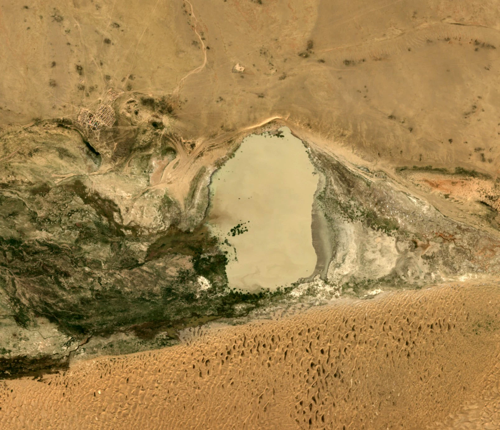
Satellite imagery of a central saline lake surrounded by arid desert, scrubland, and rocky textures in southern Mongolia.
Satellite view of Taatsiin Tsagaan Lake in Mongolia, highlighting its saline basin and surrounding arid terrain.

Taatsiin Tsagaan Lake landscape and geographic character

Taatsiin Tsagaan Lake sits within the southern Gobi Desert, one of the most extensive and arid landscapes in Central Asia. The surrounding terrain is defined by desert and semi-desert conditions, with sparse vegetation, broad open vistas, and a climate characterized by significant temperature variation and limited precipitation. The lake itself, with a surface elevation of approximately 1,312 meters, occupies a relatively flat basin surrounded by these dry landscapes.

The lake's saline character shapes its visual and physical profile. Reaching roughly 24 kilometers in length and 11 kilometers in width, Taatsiin Tsagaan is substantial in scale, yet its waters differ fundamentally from freshwater lakes in feel and ecosystem. In the surrounding desert context, the lake's open water surfaces create a striking contrast with the dry land around it, though the scene is generally one of muted tones and broad horizons rather than lush shoreline vegetation.

Taatsiin Tsagaan Lake ecosystems, habitats, and plant life

The ecological character of Taatsiin Tsagaan Lake is defined by its saline waters and the broader desert wetland context of the Valley of the Lakes. Together with its neighboring lakes, it functions as a key wetland node within a vast arid landscape where surface water is otherwise scarce. The lake's ecosystem supports specialized aquatic and shoreline communities adapted to high salinity and seasonal variation in water levels.

These conditions create habitat patterns that differ markedly from typical freshwater wetlands. Saline lakes in the Gobi region tend to support distinct microbial, invertebrate, and plant communities, and their value to waterbirds stems in part from the food resources these specialized communities provide. The clustering of several saline lakes within a relatively small geographic area amplifies their collective ecological role.

Taatsiin Tsagaan Lake wildlife and species highlights

Taatsiin Tsagaan Lake's wildlife profile is dominated by its significance for waterbirds, particularly migratory waterfowl that use the lake as a staging area during their annual movements. The combination of open water, saline habitat characteristics, and relative isolation within the Gobi Desert makes it attractive to a range of waterbird species.

The lake has drawn particular attention for its possible role as a breeding area for the Relict Gull, a globally rare species whose breeding distribution remains incompletely documented. This connection has added to the conservation interest surrounding the lake and the broader Valley of the Lakes complex. The recognition of Taatsiin Tsagaan as an Important Bird Area by BirdLife International is grounded in these waterbird values, which form the core of the lake's wildlife significance.

Taatsiin Tsagaan Lake conservation status and protection priorities

Taatsiin Tsagaan Lake holds significant international conservation standing through multiple overlapping designations. It was designated under the Ramsar Convention as a wetland of international importance on 6 July 1998 under the official name Taatsiin Tsagaan Nuur, and along with the neighboring Böön Tsagaan, Adgiin Tsagaan, and Orog Lakes, it forms part of the Valley of the Lakes Ramsar site. This recognition places it within a global framework of wetlands identified as critical for waterbird conservation and ecological function.

In addition to its Ramsar status, Taatsiin Tsagaan has been recognized by BirdLife International as an Important Bird Area, a separate designation that reflects its specific value for bird populations. The lake's conservation importance lies in the way it functions as a reliable habitat node within an otherwise arid landscape, supporting migratory waterfowl and potentially rare breeding species such as the Relict Gull. These overlapping conservation designations underscore the lake's role as one of the more ecologically meaningful water bodies in the Mongolian Gobi.

Top sights and standout views in Taatsiin Tsagaan Lake

Taatsiin Tsagaan Lake stands out as one of the few substantial inland water bodies in the southern Gobi Desert, giving it disproportionate ecological value within a vast arid landscape. Its inclusion in the Valley of the Lakes Ramsar designation places it among the internationally recognized wetland complexes of Central Asia.

The lake's recognition by BirdLife International as an Important Bird Area highlights its specific role in supporting migratory waterfowl and its potential significance for rare species such as the Relict Gull. Together, these designations reflect a conservation profile that is broad-based in wetland importance and specific in avian value.
Monthly climate preview

Long term temperature ranges and monthly precipitation data for Taatsiin Tsagaan Lake

Taatsiin Tsagaan Lake Climate Normals and Measured Monthly Weather Patterns

Representative coordinate measurements record substantial shifts in monthly temperature and precipitation across the year at Taatsiin Tsagaan Lake. Detailed climate normals provide a complete twelve month breakdown of average highs, lows, and precipitation rates.
Annual mean3 °C
-16 °C20 °C
Jan-16°
Feb-12°
Mar-4°
Apr
May12°
Jun18°
Jul20°
Aug18°
Sep11°
Oct
Nov-6°
Dec-14°
Warmest month
July

20.5 °C

Coolest month
January

-16 °C

Wettest month
July

1.3 mm/day

Driest month
January

0.1 mm/day

Park location guide

Geography guide, regional context, and park location map for Taatsiin Tsagaan Lake

Taatsiin Tsagaan Lake park geography, regions, and map view in Mongolia

Understand where Taatsiin Tsagaan Lake sits in Mongolia through a broader geographic reading of the surrounding landscape, nearby location context, and its mapped position within the national park landscape.

How Taatsiin Tsagaan Lake fits into Mongolia

Mongolia is a landlocked sovereign state in East Asia, known for its vast steppe landscapes, nomadic culture, and historical significance as the heartland of the Mongol Empire founded by Genghis Khan in 1206. The country has a population of approximately 3.5 million people and is the world's most sparsely populated sovereign state. Ulaanbaatar is the capital and largest city, home to roughly half the population.

Wider geography shaping Taatsiin Tsagaan Lake in Mongolia

Mongolia is located in East Asia, landlocked between Russia to the north and China to the south. The country occupies the Mongolian Plateau and features diverse terrain including grassy steppe, mountains in the north and west, and the Gobi Desert in the south. It covers 1,564,116 km2, making it the second largest landlocked country in the world.

Map view of Taatsiin Tsagaan Lake

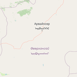
Use this park location map to pinpoint Taatsiin Tsagaan Lake in Mongolia, understand its exact geographic position, and read its mapped placement within the surrounding landscape more clearly.

Pigeon | © OpenStreetMap contributors

Location context for Taatsiin Tsagaan Lake

Övörkhangai Province

Visualizing the saline lake terrain, desert habitats, and wetland geography of Mongolia

Taatsiin Tsagaan Lake Photos and Landscape Scenery in the Gobi Desert

Visual documentation captures the expansive desert terrain, saline shorelines, and wetland habitats defining Taatsiin Tsagaan Lake. Studying photographic records reveals the stark environmental contrasts and avian habitats characterizing this protected desert basin.

Satellite imagery of a central saline lake surrounded by arid desert, scrubland, and rocky textures in southern Mongolia.

Park atlas

Compare adjacent desert wetlands and regional protected landscapes across the arid basin.

Exploring Parks Near Taatsiin Tsagaan Lake and Protected Areas Across the Region

Browsing other protected areas near Taatsiin Tsagaan Lake reveals the broader network of saline wetlands spanning the southern Gobi Desert. Comparing similar regional reserves provides valuable context for understanding arid zone conservation and avian habitats.
National parkMongolia
About 94 km away#1 closest

West

Ikh Bogd Uul National Park: Explore Mongolia's Protected Landscape and Geography

Discover mapped terrain and protected area context.

Ikh Bogd Uul National Park offers a unique window into Mongolia's protected landscapes. This page delves into the park's specific geographic setting, its mapped boundaries, and its character as a national park. Users can explore the foundational data for understanding its natural terrain and its role within the country's conservation atlas, providing a concrete basis for geographic discovery and appreciating the scope of protected areas in the region.

Area
2,629 km²
Established
2008
IUCN
II
Relief
Mountain
Protected areaBayankhongor Province
About 119 km away#2 closest

West

Valley of the Lakes: Protected Intermontane Basin and Wetland Geography in Mongolia

A vast depression defined by saline lake chains and arid steppe ecosystems.

Stretching between the Khangai and Gobi-Altai mountain systems, the Valley of the Lakes features a complex mosaic of solonchak soils, takir flats, and barchan sand dunes. This protected area is recognized for its internationally significant wetland habitats and its role as a key geographic link in the Central Asian migratory flyway.

Area
456 km²
Established
1998
Relief
Upland
Scope
Terrestrial
National parkÖmnögovi Province
About 151 km away#3 closest

South

Gobi Gurvansaikhan National Park: National Park Protected Landscape and Geographic Atlas

Mapped terrain and regional geography of this Mongolian protected area.

Navigate the atlas-focused details of Gobi Gurvansaikhan National Park, a key protected area situated in Ömnögovi Province. This entry provides essential geographic context, detailing the park's mapped boundaries and its role within the regional landscape. Understand the distinct terrain and environmental geography that define this Mongolian national park, offering a structured foundation for atlas-based discovery and learning about conservation landscapes.

Area
27,000 km²
Established
1993
IUCN
II
Relief
Mountain
National parkMongolia
About 227 km away#4 closest

North

Khangai Nuruu National Park: Discover Mongolia's Protected Mountain Landscape and Atlas Context

Explore mapped boundaries and diverse ecosystems across its terrain.

Khangai Nuruu National Park stands as a vast national park in central Mongolia, characterized by its diverse protected landscapes and significant geographic scope. Spanning the Khangai Mountains, it presents a remarkable ecological transition from alpine meadows and taiga forests to steppe and riparian environments. This park offers a rich atlas exploration opportunity, highlighting its mapped boundaries and the unique regional geography that defines its protected status, making it a key point of discovery for understanding Mongolian conservation areas.

Area
8,885 km²
Established
1996
IUCN
II
Relief
Mountain
Nature reserveÖmnögovi Province
About 240 km away#5 closest

South

Tost Tosonbumba Nature Reserve: Mapping the Protected Mountain Landscapes of the South Gobi

A rugged desert-mountain ecosystem within Ömnögovi Province

Tost Tosonbumba Nature Reserve provides a critical protected corridor of steep ravines, rocky spurs, and cliff faces set against the vast gravel plains of the South Gobi Desert. This atlas entry examines the physical boundaries and ecological terrain that define this protected landscape, illustrating its distinct position within the regional geography of Ömnögovi Province in southern Mongolia.

Area
7,284 km²
Established
2016
Relief
Mixed relief
Water
Minor water
National parkMongolia
About 306 km away#6 closest

Northeast

Khogno Khan National Park: A National Park with Distinct Mongolian Landscape Identity

Explore its mapped terrain and regional geographic context.

Khogno Khan National Park is a designated national park offering a specific focus for protected landscape discovery. Users can explore its geographic placement within Mongolia and understand its role as a mapped natural area. The park's identity as a protected territory provides critical context for those interested in the atlas of East Asian landscapes and regional geography, highlighting a distinct area for geographic study.

Area
841 km²
Established
2003
IUCN
II
Relief
Mountain
A horizontal watercolor illustration depicting a soft, green landscape with distant rolling hills, foreground meadows, and flowering bushes under a pale sky.
Protected areaArkhangai Province
About 307 km away#7 closest

North

Ögii Lake Protected Area: A Comprehensive Geographic Overview of the Mongolian Steppe

Freshwater basin and wetland geography in Arkhangai Province

Ögii Lake represents a pivotal protected landscape in central Mongolia, defined by its 25 square kilometer surface area and gentle, shallow underwater topography. This site functions as an ecological nexus for migratory waterbirds and is essential for understanding the transition between open grassland and the mountainous terrain of the Khangai region.

Area
25.7 km²
Established
2006
Relief
Lowland
Access
Access unknown
A minimalist watercolor painting showing a soft, hazy landscape of green rolling hills and distant mountains bordering a light-colored lake.
National parkArkhangai Province
About 361 km away#8 closest

North

Khorgo-Terkhiin Tsagaan Nuur National Park: Volcanic Terrain and Lake Geography

A protected highland landscape in Arkhangai Province

Explore the distinct physical geography of Khorgo-Terkhiin Tsagaan Nuur National Park, where the extinct Khorgo volcano borders a vast freshwater lake. This protected area offers a look at the mosaic of birch forest and alpine slopes within the Khangai range. The mapping of this central Mongolian site reveals how volcanic activity and mountain hydrology converge to shape its unique natural horizon.

Relief
Mountain
Climate
Alpine
Scope
Terrestrial
Water
Water-dominated

Common questions about visiting, size, designation, and location context for Taatsiin Tsagaan Lake

Taatsiin Tsagaan Lake FAQs for park facts, access, geography, and protected area context

Find quick answers about Taatsiin Tsagaan Lake, including protected-area facts, park geography, trail and visitor context, and how the park fits into its surrounding country and regional landscape.
MoriAtlas Explorer

Continue Your Protected Areas Search Across the Global Atlas

Deepen your exploration by continuing the structured search for national parks and protected areas worldwide. Utilize the comprehensive filtering capabilities to compare different conservation landscapes and refine your understanding of global park geography. Discover more about the distribution and characteristics of protected natural areas.

Global natural geography