

Mori Atlas logo
Protected landscapeTalaytay Protected Landscape

Mapping the continuous dipterocarp forest corridors from the Sierra Madre highlands to the coast

Talaytay Protected Landscape: A Deep Dive into Sierra Madre Watershed Geography and Terrain

Talaytay Protected Landscape encompasses a vital watershed corridor within the rugged Sierra Madre mountain range in Aurora, Philippines. This protected area traces the Talaytay River from steep inland ridges down through lowland slopes to the coastal edge of Dinalungan. The region serves as a critical biological bridge, featuring dense dipterocarp forest cover that provides essential habitat for native wildlife while safeguarding water resources across Central Luzon.

protected landscapewatersheddipterocarp forestSierra Madrelowland forestriver system

Talaytay Protected Landscape

Protected landscape

Park overview

Structured park overview, official facts, and landscape profile for Talaytay Protected Landscape

Talaytay Protected Landscape park facts, protected area profile, and essential visitor context

Review the core facts for Talaytay Protected Landscape, including designation, size, terrain, visitor scale, habitats, and operating context in one park-focused overview.

About Talaytay Protected Landscape

Talaytay Protected Landscape occupies a stretch of the Sierra Madre in northern Aurora province, a region that forms part of the longest mountain range in the Philippines. The Sierra Madre in this area is heavily forested, and the protected landscape centers on the full course of the Talaytay River, from its headwaters in the interior mountains to its lower reaches near the Pacific coast. This continuity from ridge top to coast gives the reserve an unusually complete profile of slope environments, ranging from steep interior terrain to gentler lowland settings around Dinalungan.

The reason the area was first placed under protection was less its scenery than its function as a watershed. Water originating in the forested Sierra Madre slopes supplies communities downstream, and protecting the forest cover was seen as essential to maintaining that supply. As a result, even though the protected landscape is also biologically rich, its identity is closely tied to the idea of an intact, working watershed anchored in native dipterocarp forest.

Ecologically, the reserve is significant because it preserves a representative stand of lowland and lower montane dipterocarp forest, a forest type that has been heavily reduced elsewhere in the Philippines. Within this setting, the park supports populations of Philippine deer, Philippine long-tailed macaques, and various bird species that rely on the closed-canopy forest environment of the Sierra Madre.

Quick facts and research context for Talaytay Protected Landscape

Talaytay Protected Landscape is a 3,526.29-hectare reserve in northern Aurora, Philippines, on the western flank of the Sierra Madre. It covers the headwaters and course of the Talaytay River from the interior mountains down to the coast at Dinalungan. First proclaimed a watershed forest reserve in 1990 and reclassified as a protected landscape in 2000, the area is administered by the Department of Environment and Natural Resources.

Protection and recognition

Documented terrestrial protection scope and official recognition details

Talaytay Protected Landscape Protection Status and International Recognition

Talaytay Protected Landscape maintains a documented terrestrial protection scope within the global conservation network. Official records outline baseline designation parameters and management classifications for the protected area.

Protection details

Protection scope
Terrestrial
Transboundary protection
No
Park context

Deeper park guide and search-rich context for Talaytay Protected Landscape

Talaytay Protected Landscape history, landscape, wildlife, and travel context

Explore Talaytay Protected Landscape through its history, landscape character, ecosystems, wildlife, conservation priorities, cultural context, and seasonal travel timing in a structured park guide built for atlas discovery and search intent.

Why Talaytay Protected Landscape stands out

Talaytay Protected Landscape is best known for protecting the Talaytay River watershed within the Sierra Madre mountain range. The reserve is valued both for its dipterocarp forest cover, which harbors commercially and ecologically important tree species, and for the conservation of native Philippine wildlife that depends on continuous upland forest habitat.

Talaytay Protected Landscape history and protected-area timeline

Talaytay was first placed under government protection in 1990, when President Corazon Aquino signed Proclamation No. 670, designating the area as a watershed forest reserve. This initial designation reflected the importance of the Talaytay River basin for water supply and forest conservation in Aurora.

In 2000, the reserve's status was elevated when President Joseph Estrada signed Proclamation No. 283, reclassifying the area from a watershed forest reserve to a protected landscape. The change broadened the area's conservation objectives while preserving its core watershed function. Today, the protected area is administered by the Department of Environment and Natural Resources, which manages it alongside other protected areas in the Sierra Madre corridor.

Talaytay Protected Landscape landscape and geographic character

The landscape of Talaytay Protected Landscape follows the full length of the Talaytay River as it descends from the Sierra Madre interior to the coast. The upstream portion of the protected area is characterized by rugged interior terrain, with steep ridges and forested slopes that form the headwaters of the river. These higher sections are part of the broader Sierra Madre range, the longest mountain chain in the Philippines, which runs along eastern Luzon.

As the Talaytay River moves downstream, the terrain eases into lower slopes and eventually lowland areas that reach the municipality of Dinalungan, where the river meets the coast. This continuous gradient from mountain interior to coastal lowland produces a varied physical setting within the reserve, although the dominant visual impression remains one of forested Sierra Madre slopes rising above the river corridor.

Talaytay Protected Landscape ecosystems, habitats, and plant life

The natural character of Talaytay Protected Landscape is defined by dipterocarp forest, the broad family of tall hardwood trees that historically dominated the lowland and lower montane forests of the Philippines. The reserve is known to harbor several important dipterocarp species, including apitong, tanguile, mayapis, white lauan, red lauan, bagtikan, and mangasinoro, many of which are valued both ecologically and for their timber.

The combination of steep forested slopes and continuous canopy cover supports a forest ecosystem that retains much of its original character, in contrast to many formerly forested lowland areas of Luzon that have been converted to agriculture or settlement. This intact forest environment also provides the habitat conditions needed by the park's mammal and bird populations.

Talaytay Protected Landscape wildlife and species highlights

Talaytay Protected Landscape supports a community of native Philippine wildlife that depends on the closed-canopy forest environment of the Sierra Madre slopes. Among the mammal species recorded in the area is the Philippine deer, a native ungulate that has become restricted to remaining forest strongholds across the country, and the Philippine long-tailed macaque, which inhabits the forested slopes along the river system.

The reserve also provides habitat for a range of avifauna, reflecting the general importance of the Sierra Madre as one of the most important remaining forest blocks for forest-dependent birds in Luzon. The presence of these species underscores the role of protected areas like Talaytay in maintaining viable populations outside of the more heavily populated and deforested parts of the island.

Talaytay Protected Landscape conservation status and protection priorities

From a conservation perspective, Talaytay Protected Landscape serves a dual role. It protects a functioning watershed that supplies water to surrounding communities in Aurora, and it preserves a contiguous block of dipterocarp forest that supports native wildlife. Together, these functions make the reserve an important component of the larger system of protected areas in the Sierra Madre, a mountain range widely regarded as a critical refuge for biodiversity in the Philippines.

The 1990 designation as a watershed forest reserve recognized the area's hydrological importance, while the 2000 reclassification as a protected landscape signaled a broader commitment to maintaining the area's ecological and landscape values. Continued protection of the forest cover is central to sustaining both the watershed function and the habitat value of the area.

Top sights and standout views in Talaytay Protected Landscape

Talaytay Protected Landscape stands out for the way it links a forested Sierra Madre watershed to the coast of Aurora within a single protected area. The reserve's combination of dipterocarp forest cover, native wildlife, and its history as a long-standing watershed protection site in the Sierra Madre gives it a distinctive place among the protected areas of Central Luzon.

Best time to visit Talaytay Protected Landscape

The climate of northern Aurora is shaped by its position on the eastern flank of Luzon, where the Sierra Madre intercepts moisture from the Pacific. Conditions are generally wetter for much of the year, while drier periods tend to offer more comfortable access to forest trails and clearer views. Because the protected landscape centers on a forested watershed, any visit benefits from favoring periods of stable weather that allow exploration of the river system without elevated flood or landslide risk in the steep interior terrain.

Monthly climate preview

Long-term temperature ranges and monthly precipitation averages for Aurora

Talaytay Protected Landscape Climate Normals and Annual Weather Patterns

Representative coordinate records show measured monthly temperature variations alongside shifting precipitation averages across the year at Talaytay Protected Landscape. Reviewing the complete twelve-month climate profile reveals long-term atmospheric rhythms and detailed meteorological baselines.
Annual mean26 °C
24 °C28 °C
Jan24°
Feb24°
Mar25°
Apr26°
May28°
Jun28°
Jul27°
Aug27°
Sep27°
Oct27°
Nov26°
Dec25°
Warmest month
June

27.7 °C

Coolest month
January

24.1 °C

Wettest month
October

10.7 mm/day

Driest month
February

3.4 mm/day

Park location guide

Geography guide, regional context, and park location map for Talaytay Protected Landscape

Talaytay Protected Landscape park geography, regions, and map view in Philippines

Understand where Talaytay Protected Landscape sits in Philippines through a broader geographic reading of the surrounding landscape, nearby location context, and its mapped position within the national park landscape.

How Talaytay Protected Landscape fits into Philippines

The Philippines, officially the Republic of the Philippines, is an archipelagic nation in Southeast Asia comprising approximately 7,641 islands categorized into three main geographical divisions: Luzon, Visayas, and Mindanao. Located in the western Pacific Ocean, it shares maritime borders with Taiwan, Japan, Palau, Indonesia, Malaysia, Vietnam, and China. Manila serves as the capital city, while Quezon City is the most populated city, both within Metro Manila.

Wider geography shaping Talaytay Protected Landscape in Philippines

The Philippines is an archipelagic nation in Southeast Asia, positioned in the western Pacific Ocean. Its islands are bounded by the South China Sea to the west, Philippine Sea to the east, and Celebes Sea to the south. The country shares maritime borders with Taiwan to the north, Japan to the northeast, Palau to the east and southeast, Indonesia to the south, Malaysia to the southwest, Vietnam to the west, and China to the northwest.

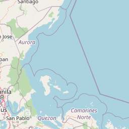
Map view of Talaytay Protected Landscape

Use this park location map to pinpoint Talaytay Protected Landscape in Philippines, understand its exact geographic position, and read its mapped placement within the surrounding landscape more clearly.

Pigeon | © OpenStreetMap contributors

Location context for Talaytay Protected Landscape

Aurora
Park atlas

Compare adjacent mountain and coastal protected landscapes across the region

Parks Near Talaytay Protected Landscape and Surrounding Regional Reserves

Browse other parks near Talaytay Protected Landscape to examine connected watershed systems and forested mountain corridors. Expanding the geographic comparison reveals broader regional conservation networks across the surrounding Sierra Madre terrain.
Protected landscapeAurora
About 6.1 km away#1 closest

Southwest

Simbahan-Talagas Protected Landscape: Geographic Profile and Sierra Madre Forest Mapping

An essential watershed and dipterocarp habitat in Aurora province.

Analyze the protected boundaries and hydrological features of the Simbahan-Talagas Protected Landscape. This region features a dense network of river systems and continuous dipterocarp forest cover that extends across the eastern foothills of the Sierra Madre mountain range in Luzon.

Area
22.66 km²
Established
2000
IUCN
V
Relief
Mountain
Protected landscapeQuirino
About 27 km away#2 closest

Northwest

Quirino Protected Landscape: Exploring the Sierra Madre and Cagayan River Watershed

Mountainous forest geography in the province of Quirino

Spanning roughly two thirds of the province of Quirino, this protected landscape is a strategic natural feature of northern Luzon. Defined by the confluence of the Sierra Madre and Caraballo mountain ranges, it serves as a massive reservoir for the Upper Cagayan River. The terrain consists of dense rainforest ridges, deep river valleys, and isolated peaks, playing a central role in regional biodiversity and watershed conservation.

Area
1,759.44 km²
Established
2004
IUCN
V
Relief
Mountain
National parkNueva Vizcaya
About 70 km away#3 closest

Northwest

Bangan Hill National Park: A Protected Landscape within Nueva Vizcaya's Geography

Explore its mapped terrain and cultural significance.

Bangan Hill National Park is a crucial protected area nestled in Nueva Vizcaya, Philippines. This page details its specific geography, including its role as a distinct hill within the broader Cagayan Valley landscape. Users can explore the park's mapped boundaries, understand its role as a national park, and discover the surrounding mountain context of the Caraballo and Cordillera Central ranges. It offers a unique perspective on the region's natural and historical significance, serving as a focal point for protected landscape exploration.

Area
0.139 km²
Established
1995
IUCN
II
Relief
Mixed relief
Wildlife reserveNueva Ecija
About 88 km away#4 closest

Southwest

Pantabangan, Carranglan Watershed Forest Reserve: Geography and Protected Area Context

Mountainous watershed landscapes in Northern Nueva Ecija

Spanning the meeting point of the Sierra Madre and Caraballo mountains, this protected wildlife reserve encompasses the massive Pantabangan Lake reservoir. The region provides a complex look at how natural forest ecosystems and large-scale water management infrastructure integrate within the Philippine landscape, offering a unique perspective on regional hydrology and botanical biodiversity.

Area
845 km²
Established
1969
IUCN
VI
Relief
Mountain
National parkPhilippines
About 95 km away#5 closest

Southwest

Aurora Memorial National Park: A Protected Landscape in the Philippines' Sierra Madre

Explore mapped boundaries and endemic avian habitat.

Aurora Memorial National Park represents a critical conservation area situated within the Philippines' Sierra Madre mountain range. Spanning a significant stretch along the eastern mountain slopes, this national park is characterized by its lowland dipterocarp forest ecosystem, recognized for supporting diverse flora and fauna. It is particularly noted as an Important Bird Area, crucial for endemic species like the Philippine eagle and various other avian populations, highlighting its ecological significance within the archipelago's geography.

Area
56.76 km²
Established
1937
IUCN
V
Relief
Mountain
National parkPhilippines
About 99 km away#6 closest

North

Fuyot Springs National Park: Philippines Protected Area with Springs, Caves & Waterfalls

Explore Sierra Madre mountain terrain and natural landscape features.

Fuyot Springs National Park offers a detailed look at a unique protected landscape within the Philippines' Sierra Madre mountain range. This atlas perspective focuses on the park's defining natural springs, its exploration-ready cave systems such as Main Cave and Altar Cave, and scenic features like Pinzal Falls. Understand the geographic context of this protected area and its mountainous terrain for landscape discovery.

Area
8.19 km²
Established
1938
IUCN
V
Relief
Mountain
Protected landscapePhilippines
About 125 km away#7 closest

West

Lower Agno Watershed Forest Reserve: Watershed Geography and Mountain Terrain in the Philippines

A vital river corridor and pine forest protected landscape

Explore the structured geography of the Lower Agno Watershed Forest Reserve, defined by its 34.59 kilometer river corridor and dense network of tributaries. From the Benguet pine forests of the Cordillera Central to the industrial landscape surrounding the San Roque Dam, this reserve serves as a complex model of water management, rugged mountain topography, and long term mining heritage in the Philippine highlands.

Area
393.04 km²
Established
1983
IUCN
V
Relief
Mountain
Illustration of a river with bamboo boats, people rowing, limestone cliffs, and trees
National parkNueva Ecija
About 129 km away#8 closest

Southwest

Minalungao National Park: Protected Landscape and Geographic Context in Nueva Ecija

Explore the mapped boundaries of this Philippines national park.

Delve into the specifics of Minalungao National Park, a protected natural area identified as a national park in the Philippines. This exploration focuses on its distinct geographic identity within Nueva Ecija, highlighting the importance of its mapped boundaries and regional landscape. Understand the park's role as a protected land entity for atlas-based discovery.

Area
20.18 km²
Established
1967
IUCN
V
Relief
Upland

Common questions about visiting, size, designation, and location context for Talaytay Protected Landscape

Talaytay Protected Landscape FAQs for park facts, access, geography, and protected area context

Find quick answers about Talaytay Protected Landscape, including protected-area facts, park geography, trail and visitor context, and how the park fits into its surrounding country and regional landscape.
MoriAtlas Explorer

Continue Your Protected Areas Search Across the Global Atlas

Deepen your exploration by continuing the structured search for national parks and protected areas worldwide. Utilize the comprehensive filtering capabilities to compare different conservation landscapes and refine your understanding of global park geography. Discover more about the distribution and characteristics of protected natural areas.

Global natural geography