

Mori Atlas logo
National parkTarangire National Park

Discover a vital national park within Tanzania's Manyara Region

Tarangire National Park: Mapped Boundaries and Protected Landscape Geography

(Hifadhi ya Taifa ya Tarangire)

Tarangire National Park represents a significant protected area within the Manyara Region of Tanzania, offering a unique geographic focus for atlas exploration. This page details the park's specific boundaries and its place within the natural landscape context of northern Tanzania. Users can explore the park's geographic identity, understanding its mapped terrain and its role as a key component of the region's protected lands.

Elephant ViewingBaobab LandscapeSavanna WildernessDry Season MigrationAfrican SafariBig Five Habitat

Tarangire National Park

National park

Park overview

Structured park overview, official facts, and landscape profile for Tarangire National Park

Tarangire National Park park facts, protected area profile, and essential visitor context
Review the core facts for Tarangire National Park, including designation, size, terrain, visitor scale, habitats, and operating context in one park-focused overview.

About Tarangire National Park

Tarangire National Park occupies a significant portion of the Tarangire Ecosystem in northern Tanzania, a region defined by its dramatic seasonal rhythms and the large-scale migrations of grazers that move through the area. The park's central feature is the Tarangire River, which flows through the protected area and provides the critical water source that sustains massive concentrations of wildlife during the long dry season from May through November. When the rains cease and the surrounding plains become arid, animals from the broader ecosystem converge on the park's permanent water sources, creating extraordinary wildlife densities that rival the more famous Serengeti migrations. The landscape varies from open grasslands dotted with ancient baobabs to dense woodland and papyrus swamps, offering diverse habitats within a relatively compact area. This heterogeneity supports a remarkable range of species and makes Tarangire a particularly rewarding destination for wildlife viewing throughout the year.

Quick facts and research context for Tarangire National Park

Tarangire National Park lies in the Manyara Region of northern Tanzania, with Arusha as the nearest major city located roughly two hours drive to the north. The park was established in 1970 and is administered by the Tanzania National Parks Authority. It occupies roughly 2,850 square kilometers of terrain characterized by granitic ridges, river valleys, and extensive swamp systems. The park supports over 550 bird species and is particularly famous for its dense elephant population, which represents one of the largest remaining herds in East Africa. The landscape is dominated by Acacia and Combretum woodlands, interspersed with seasonally flooded grasslands and iconic baobab trees.

Park context

Deeper park guide and search-rich context for Tarangire National Park

Tarangire National Park history, landscape, wildlife, and travel context
Explore Tarangire National Park through its history, landscape character, ecosystems, wildlife, conservation priorities, cultural context, and seasonal travel timing in a structured park guide built for atlas discovery and search intent.

Why Tarangire National Park stands out

Tarangire is most renowned for its extraordinary elephant populations, which reach spectacular densities during the dry season months. The park is also famous for its ancient baobab trees, some of which are estimated to be over a thousand years old and form an iconic part of the park's silhouette. The seasonal congregation of thousands of zebras, wildebeest, and cape buffalo around the Tarangire River and permanent swamps creates one of the most impressive wildlife spectacles in Tanzania. Additionally, the park's distinctive termite mounds, some abandoned and colonized by dwarf mongooses, add to the unique character of the landscape.

Tarangire National Park history and protected-area timeline

Tarangire National Park was officially established in 1970, becoming part of Tanzania's growing network of protected areas managed by the Tanzania National Parks Authority. Prior to its designation as a national park, the area existed as a game reserve and had long been recognized for its rich wildlife populations and ecological significance within the broader northern Tanzania circuit. The establishment of the park provided formal legal protection for the Tarangire Ecosystem and its remarkable wildlife populations, particularly the large herds of elephants that had historically used the area as a dry-season refuge. In recent decades, the park has gained prominence as a focus for wildlife research, particularly studies on African bush elephant behavior and Masai giraffe populations. The park remains an integral component of Tanzania's northern safari circuit, complementing the more famous Serengeti and Ngorongoro Conservation Area.

Tarangire National Park landscape and geographic character

The physical landscape of Tarangire National Park presents a distinctive blend of geological formations and vegetation communities that define the park's visual character. The terrain is punctuated by ancient granitic ridges that rise above the surrounding plains, creating rocky outcrops and inselbergs that add vertical relief to the generally flat savanna. The Tarangire River carves a valley through the park, bordered by permanent swamps and seasonal floodplains that retain moisture even during the driest months. These wetlands are surrounded by expanses of seasonally flooded grassland that transform dramatically between wet and dry seasons. The park's most iconic visual element is the massive baobab trees, whose massive swollen trunks and distinctive silhouettes have become synonymous with the African savanna. Between the river and the rocky ridges, the landscape transitions through Acacia woodland dominated by various Acacia species, mixed Combretum woodland, and more open grassland areas.

Tarangire National Park ecosystems, habitats, and plant life

The ecological character of Tarangire is shaped by the pronounced seasonality of the East African climate and the park's position within the larger Tarangire Ecosystem. The vegetation reflects this seasonal pattern, with Acacia woodlands dominating the higher ground while Combretum species characterize the lower slopes and valley floors. Seasonally flooded grasslands expand dramatically during the wet season and shrink to scattered patches as the dry season progresses, concentrating wildlife around the remaining water sources. The permanent swamps along the Tarangire River serve as critical refuges, maintaining green vegetation and providing water even when the surrounding plains have turned brown and dusty. This ecological dynamism, where vast areas transform from lush green to golden brown and wildlife populations shift accordingly, defines the park's natural character and makes it a living demonstration of the African savanna cycle.

Tarangire National Park wildlife and species highlights

Tarangire supports one of the highest concentrations of wildlife in Tanzania, with the dry season bringing extraordinary gatherings of large mammals around the river and swamps. The park is particularly famous for its elephants, which reach densities unmatched in most other protected areas, and researchers have documented unique behaviors including births of twin elephants, a rare occurrence across Africa. During the peak dry season from June through November, massive herds of zebra and wildebeest migrate into the park from surrounding areas, joined by large groups of cape buffalo. The resident antelope community includes waterbuck, giraffe, impala, eland, Grant's gazelle, and the small dik dik. Predators maintain a strong presence with lion, leopard, cheetah, and occasionally African wild dogs and caracals hunting the abundant prey populations. Over 550 bird species have been recorded, making Tarangire a significant destination for birdwatchers, while the ubiquitous termite mounds provide shelter for dwarf mongooses and form an interesting ecological feature of the landscape.

Tarangire National Park conservation status and protection priorities

Tarangire National Park plays a crucial role in the conservation of Tanzania's northern savanna ecosystems and was designated as a Lion Conservation Unit in 2005, recognizing its importance for maintaining viable populations of this apex predator. The park forms the core of the larger Tarangire Ecosystem, which encompasses surrounding dispersal areas and calving grounds used by migratory species during the wet season. Protecting this ecosystem is essential for maintaining the traditional migration routes that allow wildebeest and zebra populations to follow seasonal rainfall patterns. The park's elephant populations represent some of the most significant remaining herds in East Africa, and research programs focused on elephant behavior and Masai giraffe ecology contribute to broader conservation understanding. The Tanzania National Parks Authority manages the protected area, working to balance wildlife protection with sustainable tourism that provides economic benefits to surrounding communities.

Tarangire National Park cultural meaning and human context

While Tarangire National Park is primarily valued for its wildlife and ecosystem significance, the park exists within a region inhabited by pastoralist communities whose traditional land use practices shaped the landscape long before formal protection was established. The Maasai people and other local communities have historically moved their livestock through areas adjacent to the park, and these traditional practices influenced the ecological character of the surrounding landscape. The park's name derives from the local language, with Tarangire referring to the river that provides life to the ecosystem. Understanding this human context helps frame the park within the broader regional landscape where wildlife and human communities have coexisted, often contentiously, over generations.

Top sights and standout views in Tarangire National Park

The most compelling highlights of Tarangire National Park center on its extraordinary wildlife concentrations and the dramatic seasonal transformation that brings the savanna to life. The elephants of Tarangire, with their large herds and impressive tuskers, represent one of Africa's most reliable elephant viewing experiences. The annual dry-season gathering of thousands of zebras and wildebeest along the river creates a spectacle that rivals the famous Serengeti migration. The ancient baobab trees, some of which have stood for centuries, provide an iconic backdrop for wildlife photography and embody the timeless character of the African bush. The park also offers excellent predator viewing opportunities, with lions and leopards frequently encountered, while the bird life adds another dimension for visitors interested in avian diversity.

Best time to visit Tarangire National Park

The optimal time to visit Tarangire National Park aligns with the dry season from June through November, when wildlife viewing reaches its peak as animals concentrate around the Tarangire River and permanent swamps. During these months, the vegetation thins and animals become easier to spot as they gather at water sources, creating exceptional opportunities for observing large herds and predator interactions. The dry season also offers more comfortable temperatures and easier road conditions within the park. The wet season from December through May brings green landscapes and newborn animals but animals disperse more widely across the ecosystem, making wildlife viewing less predictable. The shoulder months of May and November offer a good balance between conditions and wildlife concentrations.

Park location guide

Geography guide, regional context, and park location map for Tarangire National Park

Tarangire National Park park geography, regions, and map view in Tanzania
Understand where Tarangire National Park sits in Tanzania through a broader geographic reading of the surrounding landscape, nearby location context, and its mapped position within the national park landscape.

How Tarangire National Park fits into Tanzania

Tanzania, officially the United Republic of Tanzania, is a presidential republic in East Africa within the African Great Lakes region. It was formed in 1964 through the unification of Tanganyika and Zanzibar. The country is known for its diverse wildlife, national parks including Serengeti and Ngorongoro, and significant archaeological sites with important hominid fossils.

Wider geography shaping Tarangire National Park in Tanzania

Tanzania is located in East Africa within the African Great Lakes region. It is bordered by Uganda to the northwest, Kenya to the northeast, the Indian Ocean to the east, Mozambique and Malawi to the south, Zambia to the southwest, and Rwanda, Burundi, and the Democratic Republic of the Congo to the west. The country includes the mainland and the Zanzibar Archipelago.

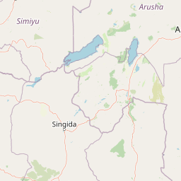
Map view of Tarangire National Park

Use this park location map to pinpoint Tarangire National Park in Tanzania, understand its exact geographic position, and read its mapped placement within the surrounding landscape more clearly.

Pigeon | © OpenStreetMap contributors

Location context for Tarangire National Park

Manyara Region
Park atlas

From Tarangire National Park, trace the geographic spread of nearby national parks, protected areas, and surrounding conservation landscapes in Tanzania.

Discover Nearby National Parks and Protected Areas, Expanding From Tarangire National Park
After exploring Tarangire National Park, continue your discovery by browsing other national parks and protected areas within Tanzania, encompassing adjacent landscapes and the broader Tarangire Ecosystem. Compare their geographic distribution, trace varied conservation zones, and understand their unique contributions to East Africa's extensive network of protected natural areas.
National parkArusha Region

Lake Manyara National Park: Protected Landscape & Rift Valley Geography in Arusha Region

Unique habitats from groundwater forests to alkaline lake shores.

Lake Manyara National Park is a distinct protected landscape situated within the Great Rift Valley of Tanzania's Arusha Region. The park's geography is shaped by the imposing escarpment wall and the alkaline Lake Manyara, creating a mosaic of habitats including rare groundwater forests, acacia woodlands, and saline grasslands. Its unique environment supports diverse wildlife and offers a prime example of regional landscape context and protected area dynamics.

Area
648 km²
Established
1960
IUCN
II
Visitors
178.5K annual
National parkArusha Region

Arusha National Park: A Protected Landscape in Tanzania's Arusha Region

Explore its mapped boundaries and regional geography.

Arusha National Park represents a significant protected landscape within the Arusha Region of Tanzania, offering specific geographic details for atlas-based exploration. This national park's identity is tied to its mapped natural terrain and its position within the broader regional context. Users can delve into the park's protected status and geographic features, making it a valuable entity for understanding the landscape of northern Tanzania.

Area
137 km²
Established
1960
IUCN
II
Visitors
66.8K annual
National parkKilimanjaro Region

Kilimanjaro National Park: Protected Landscape Geography and Atlas Exploration

Explore its mapped boundaries and regional context.

Delve into Kilimanjaro National Park, a protected national park situated in the Kilimanjaro Region. This detail page offers an atlas-driven view of the park's geographic scope, focusing on its mapped boundaries and the surrounding natural landscape. Understand the unique terrain and regional context that make this protected area a significant feature within Tanzania's geography.

Area
1,688 km²
Established
1973
IUCN
II
Visitors
52K annual
National parkKenya

Amboseli National Park: Kenya National Park Protected Landscape Atlas

Mapped geographic context and protected area boundaries.

Amboseli National Park is a protected national park in Kenya, offering a distinct geographic entity for exploration. This atlas-focused view details the park's mapped boundaries and regional landscape context. Understand its role as a national park and a significant protected area within the broader geography of Kenya for structured discovery.

Area
392 km²
Established
1974
IUCN
II
Visitors
120K annual
National parkTaita-Taveta County

Tsavo West National Park: Kenya's Protected National Park and Regional Geography

Explore mapped boundaries and natural landscapes in Taita-Taveta County.

Tsavo West National Park offers a focused exploration of protected landscape and regional geography within Kenya. Discover the mapped extent of this national park, understanding its role as a conservation area in Taita-Taveta County. This entry provides key geographic context and atlas-style information, highlighting the natural terrain and protected boundaries for detailed discovery.

Area
9,065 km²
Established
1948
IUCN
II
Relief
Mixed relief
National parkMara Region

Serengeti National Park: National Park Atlas and Protected Landscape Discovery

Explore savanna grasslands, regional geography, and mapped park boundaries.

Serengeti National Park, a significant national park within Tanzania's Mara Region, offers an unparalleled view into a vast protected landscape. This page provides access to the park's geographic identity, its defining savanna ecosystem, and its role as a critical component of the regional atlas. Understand the mapped extent of its protected boundaries and the unique natural context that supports its renowned wildlife.

Area
14,763 km²
Established
1940
IUCN
II
Visitors
350K annual
National parkTanzania

Mkomazi National Park: Tanzania's Vast Protected Savanna Landscape and Wildlife Geography

Explore its mapped terrain and conservation significance within East Africa.

Mkomazi National Park is a critical protected landscape in Tanzania, spanning over 3,200 square kilometers of classic East African semi-arid savanna woodland. This national park offers a unique atlas-style view into conservation success, particularly for its black rhinoceros sanctuary and African wild dog programs. Its landscape is characterized by rolling terrain and Acacia-Commiphora vegetation, forming a vital transboundary conservation area with Kenya that supports significant wildlife migration corridors and provides a distinct geographic context within the broader regional atlas.

Area
3,234 km²
Established
2006
IUCN
II
Visitors
1.6K annual
National parkKenya

Nairobi National Park: Detailed Geographic Overview and Protected Landscape Atlas

Explore the mapped boundaries and regional context of this Kenyan national park.

Nairobi National Park represents a significant protected national park entity within Kenya. This MoriAtlas entry provides detailed insight into its geographic placement and mapped landscape characteristics. Users can delve into the park's specific location, its protected boundaries, and its contribution to the regional geography of East Africa, facilitating structured map-based exploration and understanding of this vital conservation area.

Area
117 km²
Established
1946
IUCN
II
Relief
Mixed relief

Common questions about visiting, size, designation, and location context for Tarangire National Park

Tarangire National Park FAQs for park facts, access, geography, and protected area context
Find quick answers about Tarangire National Park, including protected-area facts, park geography, trail and visitor context, and how the park fits into its surrounding country and regional landscape.
MoriAtlas Explorer

Continue Your Protected Areas Search Across the Global Atlas

Deepen your exploration by continuing the structured search for national parks and protected areas worldwide. Utilize the comprehensive filtering capabilities to compare different conservation landscapes and refine your understanding of global park geography. Discover more about the distribution and characteristics of protected natural areas.

Global natural geography