
Mori Atlas logo
Nature reserveTeufelsseemoor Köpenick

Examining the ecological transitions and glacial topography of this unique urban wetland sanctuary

Teufelsseemoor Köpenick: A Glacial Kettle Bog and Protected Nature Reserve in Berlin, Germany

Teufelsseemoor Köpenick serves as a distinct nature reserve situated within the Köpenick district of Berlin. This protected site centers on a deep kettle bog formed during the Weichselian glaciation, creating a mosaic of open water, sedge moor, and alder swamp forest. As a Natura 2000 location, the area preserves specialized peatland habitats and serves as a critical refuge for rare bog flora and amphibians within the city boundaries.

kettle bogpeatlandmoorNatura 2000urban nature reserveglacial landscape
A flat vector-style illustration of a nature scene featuring a tall waterfall cascading down a cliff into a calm lake, surrounded by a coniferous forest, mountains in the distance, and birch trees in the foreground.

Teufelsseemoor Köpenick

Nature reserve

Park overview

Structured park overview, official facts, and landscape profile for Teufelsseemoor Köpenick

Teufelsseemoor Köpenick park facts, protected area profile, and essential visitor context

Review the core facts for Teufelsseemoor Köpenick, including designation, size, terrain, visitor scale, habitats, and operating context in one park-focused overview.

About Teufelsseemoor Köpenick

Teufelsseemoor Köpenick occupies a remarkable ecological niche inside Berlin. Tucked into the southwestern part of the Köpenick district, it sits in a landscape shaped by the last glaciation, where ice once pressed, stacked, and ultimately melted away to leave behind a deep kettle hole. Over centuries, this basin filled with meltwater, accumulated peat, and developed into a kettle bog with no natural surface outflow: an unusual hydrological setting that has produced a distinctive sequence of peatland habitats.

The reserve follows a clear ecological gradient. In its southwestern portion sits the Teufelssee itself, the cool, clear lake that fills the original dead-ice basin. From there, vegetation grades outward into a zone of reed and emergent marsh plants, then into small-sedge and peat-moss communities typical of intermediate bogs, and eventually into alder swamp forest along the margins where groundwater once supported wetter conditions. The combination of open water, peatland vegetation, and swamp woodland within such a small area gives the site a disproportionately rich habitat profile.

Although the reserve is now formally protected, its history has not been entirely natural. After the Second World War, workers dumped roughly 8,000 tons of construction debris, slag, and tar into parts of the bog in an effort to extend a local sledding run toward the Teufelssee. That contamination was removed in 2003, restoring more natural hydrological and substrate conditions. The area was then formally protected as a nature reserve under Berlin law in September 2016, and it is simultaneously part of the European Natura 2000 network (site DE3547302) for its habitat and species values.

Today, the landscape is shaped as much by management as by geology. Falling groundwater levels have encouraged greater colonization by pines and birches, which can accelerate the drying and eventual overgrowth of the bog surface. To counter this, the Berlin Forestry Office has carried out woodland removal programs, including a notable thinning effort in the winter of 2014/15, designed to slow succession and increase light availability for specialized bog species such as sundews. A roughly 300-meter wooden boardwalk now allows visitors to cross the bog without disturbing sensitive peat layers, complementing a nature trail and the nearby Teufelssee forest education building operated by the Berlin Forestry Office.

Quick facts and research context for Teufelsseemoor Köpenick

Teufelsseemoor Köpenick is a 6.45-hectare nature reserve and Natura 2000 site in the Köpenick locality of Berlin, in the borough of Treptow-Köpenick. It lies at the northern foot of the Müggelberge, just south of the Müggelheimer Damm, and wraps around the Teufelssee, an oligotrophic, spring-fed lake formed in a glacial kettle hole.

The reserve was designated on 12 September 2016 and is administered through the Berliner Wasserbetriebe in coordination with Berlin's forestry authorities. It is classified as IUCN Category IV, reflecting its role as a habitat and species management area. Peat layers in the basin reach thicknesses of around ten meters in places, and the surrounding vegetation includes reedbeds, sedge mats, peat moss communities, and alder swamp forest, making it one of the rarer surviving examples of a kettle-bog landscape within the city limits of Berlin.

Protection and recognition

Examine official Natura 2000 designations and documented protected area records.

Teufelsseemoor Köpenick Protection Status and International Recognition

Teufelsseemoor Köpenick brings together verified protection status data and international recognition sources for structured geographical analysis. Official Natura 2000 records outline the documented framework supporting conservation tracking across the protected area.
Park context

Deeper park guide and search-rich context for Teufelsseemoor Köpenick

Teufelsseemoor Köpenick history, landscape, wildlife, and travel context

Explore Teufelsseemoor Köpenick through its history, landscape character, ecosystems, wildlife, conservation priorities, cultural context, and seasonal travel timing in a structured park guide built for atlas discovery and search intent.

Why Teufelsseemoor Köpenick stands out

Teufelsseemoor Köpenick is best known for being a true kettle bog, a peatland landscape that developed inside a dead-ice depression left behind at the end of the last ice age. Its centerpiece is the Teufelssee, a cold, nutrient-poor water body that has accumulated thick peat deposits over thousands of years and now supports a rare, peatland-specific habitat mosaic within an urban setting. The reserve is also recognized for the transition from open water through reedbeds into sedge moors and eventually older alder swamp forest, a habitat gradient that fits into a compact spatial footprint. Because kettle bogs of this character are uncommon in Berlin and across much of the surrounding lowlands, the site carries ecological significance well beyond its modest area, both as a Natura 2000 site and as a refugium for bog-adapted plants and animals.
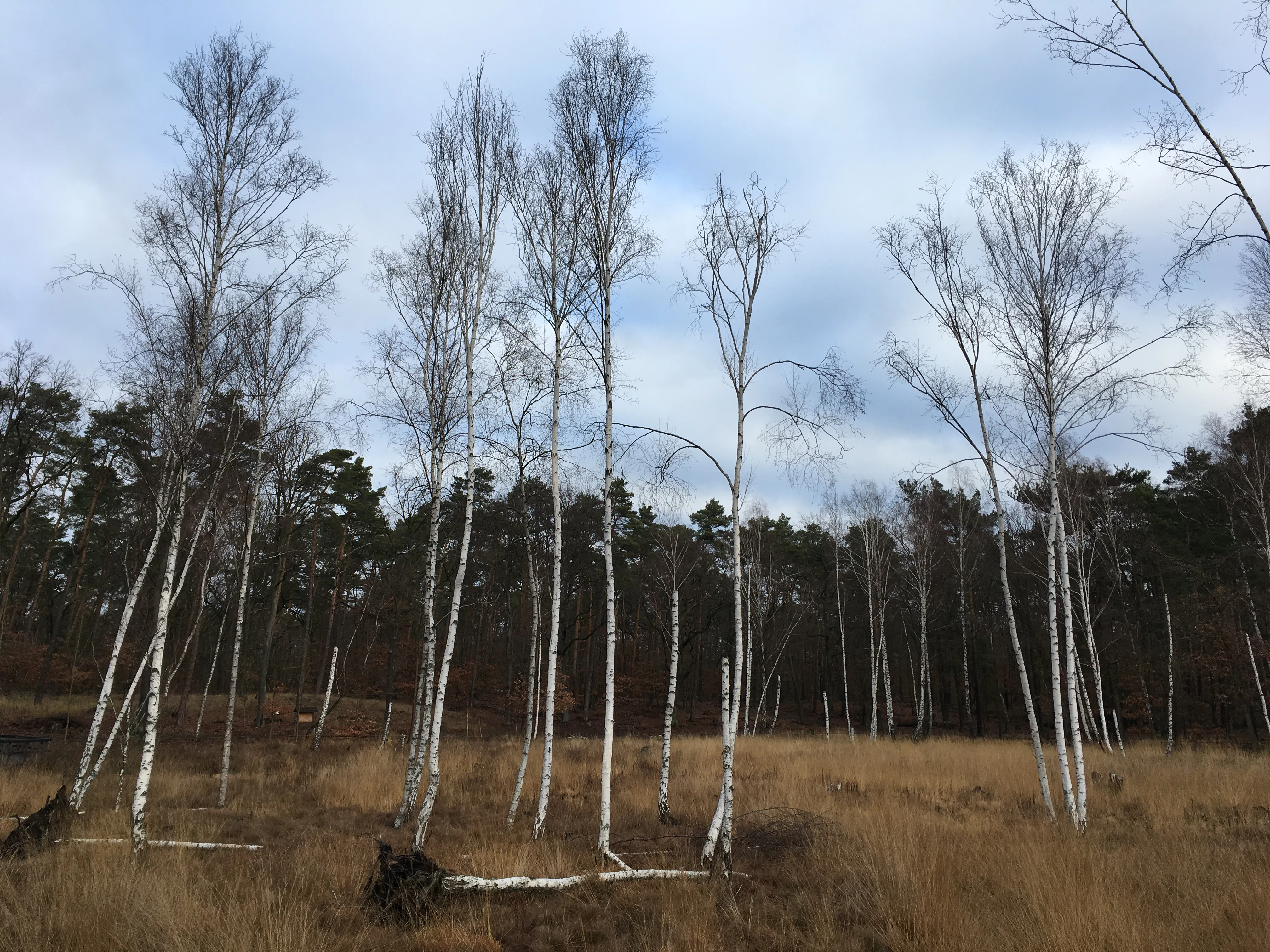
A group of slender, white-barked birch trees standing in a grassy, boggy field with a dense pine forest in the background under an overcast sky.
A view of the kettle bog landscape in Teufelsseemoor Köpenick, characterized by scattered birch trees.

Teufelsseemoor Köpenick history and protected-area timeline

The geological history of Teufelsseemoor Köpenick reaches back to the Weichselian glaciation, when advancing ice sheets reshaped the terrain south of present-day Berlin. Pressure from the ice created push moraines that today form the Müggelberge ridge to the south, while a block of ice buried in the landscape later melted in place to leave a deep kettle hole. Over time, this depression filled with meltwater and gradually shifted from a water-filled basin into a fen, then an intermediate bog, and eventually a peat-forming system with peat layers reaching up to roughly 13 meters thick in places.

The more recent, human history of the site is largely a story of damage and subsequent restoration. After the Second World War, approximately 8,000 tons of construction rubble, slag, and tar were deposited in parts of the moor to extend the local toboggan run toward the Teufelssee. These pollutants remained for decades before being removed in 2003 at a cost of about 371,000 euros, marking a major turning point in the site's recovery.

Formal protection followed more than a decade later. On 12 September 2016, the area was designated as a nature reserve under Berlin law ("Verordnung über das Naturschutzgebiet Teufelsseemoor Köpenick") and recognized as part of the European Natura 2000 network. Since then, it has been managed as both a protected landscape and an educational site, including the reconstruction of a boardwalk that had existed for around 25 years before being replaced in 2015. The new boardwalk rests on 240 larch piles driven up to eight meters into the ground and represents a significant investment in making the fragile peatland accessible without compromising its conservation.

Teufelsseemoor Köpenick landscape and geographic character

The landscape of Teufelsseemoor Köpenick is defined by the contrast between the bog basin and the surrounding glacially shaped terrain. To the south rise the Müggelberge, a low but clearly visible ridge of push moraines formed during the Weichselian glaciation, with the Kleiner Müggelberg on the western side and the Großer Müggelberg on the eastern side. The reserve itself lies along the northern foot of this ridge, framed between the wooded slopes above and the Müggelheimer Damm, a major local road that runs southeast toward the Müggelsee, to the north.

Within this small area, topography shifts from the cool, still waters of the Teufelssee in the southwest to a gently sloping fringe of reedbeds, sedge mats, and peat moss hummocks. These transitions reflect the slow infilling of the original ice kettle by organic matter, producing a layered landscape where open water, emergent vegetation, and older swamp forest stand in close proximity. Despite the urban setting, the visual impression within the reserve is one of a compact, naturalistic wetland scene, with the smooth lake surface, soft peatland edges, and the forested Müggelberge forming a quiet backdrop.
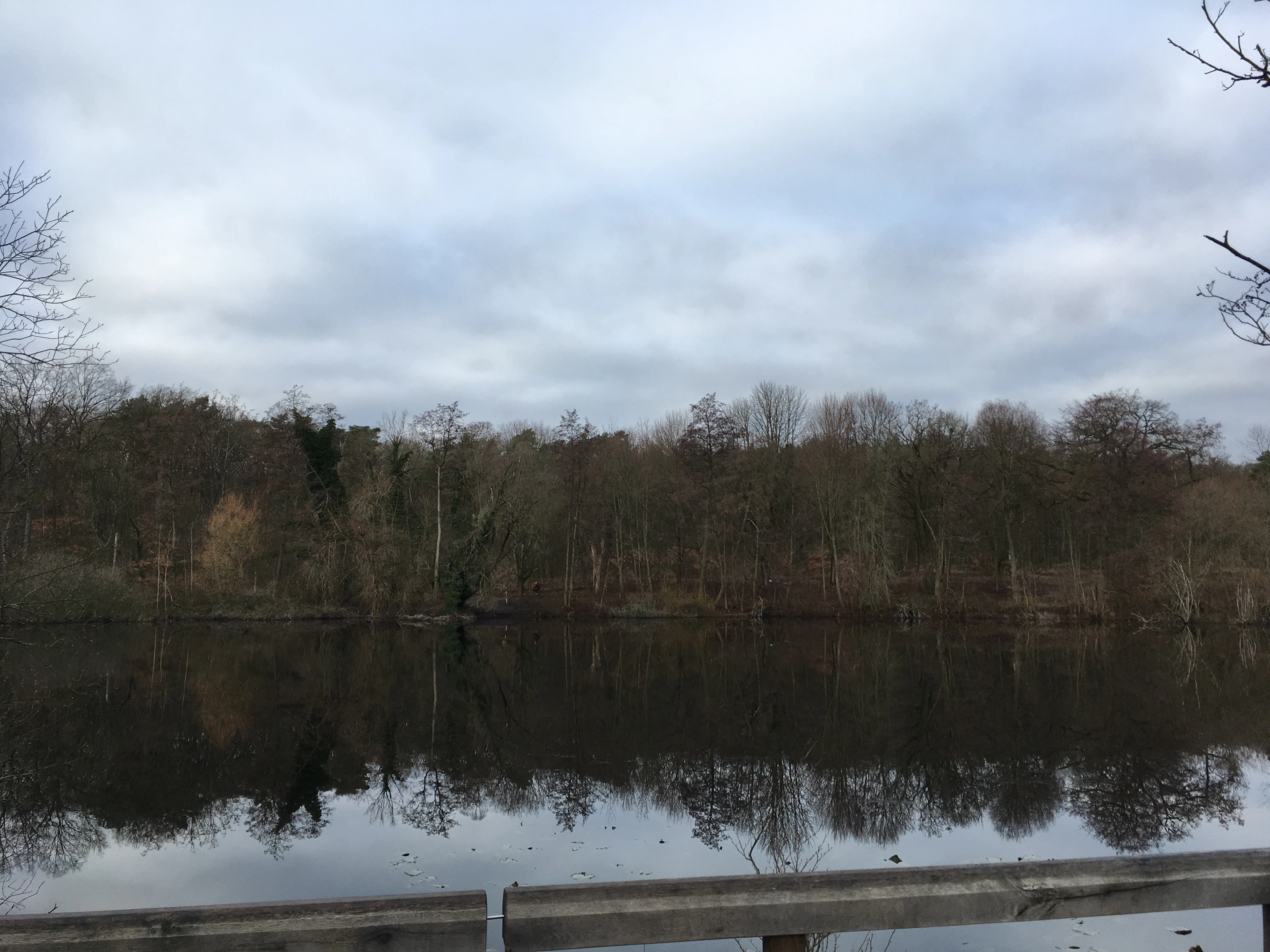
A calm lake reflects the surrounding forest under an overcast sky, viewed from a wooden boardwalk in the foreground.
A view across the Teufelssee, seen from the wooden boardwalk in Teufelsseemoor Köpenick.

Teufelsseemoor Köpenick ecosystems, habitats, and plant life

Ecologically, Teufelsseemoor Köpenick is a textbook example of a kettle-bog succession in a glacial landscape. The system lacks a natural surface outflow, and its water chemistry has shifted over time from groundwater-fed conditions to a more rain-fed, nutrient-poor, oligotrophic state, supporting the growth of peat mosses and small sedges characteristic of intermediate bog environments. Peat moss cushions and small-sedge communities dominate the open central areas, while peripheral zones host reedbeds, alder swamp forest fragments, and, where groundwater once reached higher, patches of wet woodland.

The combined presence of open water, reedbeds, peat-forming mats, and swamp forest within roughly six hectares gives the reserve an unusually high habitat density for its size. The bog surface is also a habitat for moisture- and light-dependent species such as sundews, and the surrounding transitional zones provide conditions suited to amphibians and dragonflies that depend on cool, fish-poor or carefully balanced waters. Management actions, particularly the thinning of successional trees and shrubs, are explicitly aimed at maintaining open bog conditions and at keeping these specialized habitats from closing over.

Teufelsseemoor Köpenick wildlife and species highlights

The wildlife of Teufelsseemoor Köpenick is shaped strongly by the bog's cold, nutrient-poor water and its mosaic of aquatic, wetland, and swamp forest habitats. The Teufelssee itself supports a population of bitterling, a small freshwater fish typically associated with clean, well-vegetated waters, while the shoreline reedbeds and shallow marsh areas provide breeding habitat for amphibians such as the northern crested newt, the moor frog, and the garlic toad.

Insect life is also a notable feature of the reserve. The large white-faced dragonfly, a dragonfly species closely tied to peatland and bog pool environments, has been recorded in the area, alongside other bog-associated invertebrate communities. Reptiles such as the grass snake are protected within the site, as are ground beetles that depend on the particular microhabitats created by the bog's surface structure. Together, these species illustrate how a small, well-protected kettle bog can function as an important refugium for moisture-loving wildlife even within a densely populated metropolitan region.

Teufelsseemoor Köpenick conservation status and protection priorities

The conservation significance of Teufelsseemoor Köpenick lies in the fact that it preserves an almost complete kettle-bog habitat sequence inside the city of Berlin, a setting where such landscapes are extremely scarce. Its dual designation as a Berlin nature reserve (Naturschutzgebiet) and as a Natura 2000 site (DE3547302) recognizes the European-scale value of its habitats, particularly the peat-forming communities, the oligotrophic bog vegetation, and the wildlife they support.

The site also embodies an active conservation case study. The earlier dumping of construction waste into the bog, and its subsequent removal in 2003, demonstrated the seriousness of contamination threats to urban wetlands and helped justify the formal protection that followed. Today, management focuses on resisting succession: maintaining water tables, removing encroaching trees and shrubs to slow forest overgrowth, and preserving the open conditions that bog-dependent species like sundews, moor frogs, and dragonflies require. In this sense, Teufelsseemoor Köpenick functions both as a surviving natural relic of the last ice age and as a working example of small-scale urban peatland restoration.

Teufelsseemoor Köpenick cultural meaning and human context

Although Teufelsseemoor Köpenick is primarily valued for its natural character, it also reflects a distinctive relationship between Berlin residents and the surrounding glacial landscape. The name "Teufelssee," meaning "Devil's Lake," and the broader presence of "devil" place names in the Müggelberge area hint at an older folk tradition of naming unusual, dark, or mysterious local waters and bogs. The postwar use of the bog as informal dumping ground, followed by modern cleanup, conservation, and the construction of an educational trail and forest education cabin, also illustrates how this landscape has shifted, over the span of a single lifetime, from a neglected urban backwater into a recognized piece of protected natural heritage.

Top sights and standout views in Teufelsseemoor Köpenick

Among the most distinctive features of Teufelsseemoor Köpenick are its glacial origins, visible in the kettle hole that became the Teufelssee and in the push-moraine ridge of the Müggelberge rising immediately to the south. Within the reserve, the transition from open water through reedbeds into sedge and peat-moss communities, and then into alder swamp forest, provides an unusually compact cross-section of peatland habitats. The presence of specialist species such as sundews, moor frogs, northern crested newts, and the large white-faced dragonfly gives the site a wildlife profile well beyond what its size might suggest.

Equally notable is the active conservation story: the removal of wartime debris in 2003, the formal nature reserve designation in 2016, and the ongoing forestry work to keep the bog open and wet. Visitors can experience this landscape directly via a roughly 300-meter boardwalk and the surrounding nature trail maintained by the Berlin Forestry Office, making the reserve an accessible example of urban peatland protection.

Best time to visit Teufelsseemoor Köpenick

Teufelsseemoor Köpenick can be visited across much of the year, with each season offering a slightly different experience. Spring and early summer bring active amphibian breeding in and around the Teufelssee and growing reed vegetation, while warm summer days offer the fullest sense of the bog's lush green character and the best chance to observe dragonflies and other wetland insects. Autumn can be a quieter, atmospherically rich time to walk the boardwalk, when sedges and bog vegetation take on warmer tones. In winter, frozen sections of the bog and bare deciduous vegetation offer clearer views of the underlying landforms, though visitors should expect cold conditions in an exposed wetland setting.

Monthly climate preview

Long-term representative measurements of monthly temperature and precipitation patterns

Teufelsseemoor Köpenick Climate Normals and Annual Temperature Rhythm

Representative coordinate records show average monthly temperatures shifting from sub-zero winter minimums to warm summer maximums alongside steady daily precipitation rates. Analyzing these long-term climate normals provides a clear baseline of the annual meteorological rhythm recorded across the protected landscape.
Annual mean9 °C
-1 °C20 °C
Jan-1°
Feb
Mar
Apr
May14°
Jun18°
Jul20°
Aug20°
Sep15°
Oct
Nov
Dec
Warmest month
July

20.3 °C

Coolest month
January

-0.9 °C

Wettest month
July

2.4 mm/day

Driest month
April

1.1 mm/day

Park location guide

Geography guide, regional context, and park location map for Teufelsseemoor Köpenick

Teufelsseemoor Köpenick park geography, regions, and map view in Germany

Understand where Teufelsseemoor Köpenick sits in Germany through a broader geographic reading of the surrounding landscape, nearby location context, and its mapped position within the national park landscape.

How Teufelsseemoor Köpenick fits into Germany

Germany is a federal republic in Western and Central Europe with a population of over 83 million across sixteen constituent states. It is Europe's largest economy by nominal GDP and a major global exporter and importer. The capital is Berlin, and the country borders Denmark, Poland, Czech Republic, Austria, Switzerland, France, Luxembourg, Belgium, and the Netherlands.

Wider geography shaping Teufelsseemoor Köpenick in Germany

Germany is located in Western and Central Europe, spanning 357,022 km². It borders Denmark to the north, Poland and the Czech Republic to the east, Austria and Switzerland to the south, and France, Luxembourg, Belgium, and the Netherlands to the west. The country has coastlines on the Baltic Sea and North Sea to the north, with the Alps located in the southern region.

Map view of Teufelsseemoor Köpenick

Use this park location map to pinpoint Teufelsseemoor Köpenick in Germany, understand its exact geographic position, and read its mapped placement within the surrounding landscape more clearly.

Pigeon | © OpenStreetMap contributors

Location context for Teufelsseemoor Köpenick

Berlin

Visual reference guide to glacial kettle bogs, peatland habitats, and wetland terrain

Teufelsseemoor Köpenick Photos, Scenery, and Protected Landscape Views

Visual records capture the distinctive kettle-bog topography, open water features, and peatland vegetation mosaics preserved within the Köpenick district. Photographic documentation reveals how glacial landforms and swamp forest environments shape the protected character of the reserve.

A group of slender, white-barked birch trees standing in a grassy, boggy field with a dense pine forest in the background under an overcast sky.

A wooden boardwalk with railings winds through a marshy landscape filled with thin trees and tall, dry grasses under a cloudy sky.

A calm lake reflects the surrounding forest under an overcast sky, viewed from a wooden boardwalk in the foreground.

Park atlas

Compare adjacent wetland reserves and regional glacial landscapes

Parks Near Teufelsseemoor Köpenick and Surrounding Protected Natural Areas

Continue browsing other parks near Teufelsseemoor Köpenick to examine similar kettle bogs and wetland reserves across the surrounding region. Comparing adjacent protected areas reveals broader patterns in glacial geology and urban conservation landscapes.
A watercolor painting showing a soft, abstract landscape with rolling hills, a central body of water, and a tree-lined shoreline.
Nature reserveBerlin
2 km away#1 closest

Southwest

Krumme Lake Nature Reserve: Geographic Overview and Protected Wetland Boundaries in Berlin

A preserved mosaic of alder swamp forest and Dahme floodplain habitat

Krumme Lake preserves a dense network of wetland habitats within the pine-dominated forests of Berlin's Treptow-Köpenick borough. This protected nature reserve integrates groundwater-influenced ecosystems and riparian forest remnants, providing a sanctuary for diverse amphibians and invertebrates that have become increasingly rare in surrounding urbanized landscapes.

Area
0.452 km²
Established
2004
IUCN
IV
Relief
Lowland
A horizontal watercolor painting of a calm river or wetland area with trees, shoreline grasses, and rolling hills in the background, executed in a soft, muted style.
Nature reserveBerlin
About 5 km away#2 closest

East

EU-Vogelschutzgebiet Müggelspree: Protected Nature Reserve and Spree Valley Geography

Bird sanctuary and wetland landscape in southeastern Berlin

As a protected bird sanctuary within the European Natura 2000 network, the EU-Vogelschutzgebiet Müggelspree features an intricate mix of river corridors, fens, and pine forests. This reserve maintains significant ecological connectivity through the Spree lowlands, providing stable breeding and passage environments for numerous avian species. Its unique landscape architecture offers a clear view into the intersection of glacial sand formations and active floodplain ecosystems on the outskirts of Berlin.

Area
8.002 km²
Established
1997
A wide watercolor illustration showing a calm lake with small tree-covered islands, bordered by green forests and distant hills under a pale sky.
Protected areaBrandenburg
6.1 km away#3 closest

Southeast

Wernsdorfer See Protected Area: Geographic Mapping and Landscape Context in Brandenburg

Glacial wetland mosaic featuring dunes and reedbeds

Wernsdorfer See is an essential nature reserve in Brandenburg that showcases a rare mix of habitats, from open sandy dunes and grasslands to shallow marshland and reedbeds. Managed as part of the Natura 2000 network, the site serves as a vital refuge for bird species and rare wetland flora. This overview traces the geography and terrain of the Spree valley lowland, offering a structured perspective on its conservation landscape.

Area
1.387 km²
Established
1967
Relief
Lowland
Climate
Temperate
A soft watercolor illustration of a lowland wetland landscape with a small pool of water, grasses, and scattered trees under a light sky.
Nature reserveBrandenburg
About 8.6 km away#4 closest

Southwest

Flutgrabenaue Waltersdorf Nature Reserve: Protected Wetland Geography and Regional Atlas

A significant floodplain sanctuary in the Brandenburg lowlands.

Flutgrabenaue Waltersdorf represents an ecologically rich lowland floodplain featuring sinuous watercourses, alder swamps, and traditional meadow habitats. Located south of Berlin, this reserve provides a vital geographic contrast to the urbanized infrastructure of the Brandenburg region. Use this overview to study the boundary, terrain characteristics, and regional importance of this protected marshland landscape.

Area
2.88 km²
Established
1998
IUCN
IV
Relief
Lowland
Watercolor painting of a rolling landscape with green grass, bushes, and soft-colored hills in the background.
Protected landscapeBerlin
About 8.8 km away#5 closest

North

Kaulsdorfer Seen: A Protected Landscape in Berlin with Glacial and Industrial History

Exploring the groundwater protection zones and post-mining lakes of eastern Berlin

The Kaulsdorfer Seen area represents a distinct protected landscape located in Berlin. It showcases the transition between ice-age glacial regions, featuring two prominent lakes that evolved from sand and gravel pits into a mature ecosystem of willow thickets, woodland, and reeds. This site functions as an important drinking-water protection zone, offering a structured look at the complex interplay between urban development and natural resource conservation.

Area
0.937 km²
Water
Major water bodies
A pale, minimalist watercolor painting depicting an open field with a winding stream, scattered trees, and distant rolling hills on a white background.
Nature reserveBerlin
About 9.4 km away#6 closest

Northwest

Biesenhorster Sand Nature Reserve: Protected Glacial Landscape in Berlin

Urban nature reserve featuring dry grassland and rare species habitats.

Located in eastern Berlin, Biesenhorster Sand preserves a significant glacial outwash plain that supports an extraordinary concentration of rare species. This nature reserve serves as a vital ecological corridor, protecting a mosaic of dry grassland and open sand terrain that contrasts with the surrounding urban fabric of Germany's capital.

Area
0.429 km²
Established
2021
Relief
Lowland
Scope
Terrestrial
Nature reserveBerlin
About 9.6 km away#7 closest

West

Wasserwerk Johannisthal Nature Reserve: Mapping Berlin's Industrial and Hydrological Landscape

A protected urban groundwater zone in Treptow-Köpenick.

Explore the unique geography of Wasserwerk Johannisthal, a nature reserve in Berlin that balances industrial heritage with modern environmental management. This thirty-five-hectare site offers insights into urban protected areas, showing how historic water infrastructure is now secured for groundwater monitoring and remediation, set against the backdrop of the city's complex transport and green-space network.

Area
0.35 km²
Established
2007
IUCN
IV
Relief
Lowland
Protected landscapeBerlin
About 11 km away#8 closest

West

Vogelschutzgebiet am Wildmeisterdamm in Rudow: Berlin Urban Protected Woodland Map

Historical bird sanctuary and broadleaf landscape in Neukölln

Spanning roughly 3.75 hectares in the Gropiusstadt district, this site functions as an important refuge for urban birdlife amidst dense residential development. The woodland features a mix of oak, birch, and elm trees, preserved for their ecological continuity since the site first gained official protection in the early twentieth century.

Area
0.038 km²
Established
1934
IUCN
V
Relief
Lowland

Common questions about visiting, size, designation, and location context for Teufelsseemoor Köpenick

Teufelsseemoor Köpenick FAQs for park facts, access, geography, and protected area context

Find quick answers about Teufelsseemoor Köpenick, including protected-area facts, park geography, trail and visitor context, and how the park fits into its surrounding country and regional landscape.
MoriAtlas Explorer

Continue Your Protected Areas Search Across the Global Atlas

Deepen your exploration by continuing the structured search for national parks and protected areas worldwide. Utilize the comprehensive filtering capabilities to compare different conservation landscapes and refine your understanding of global park geography. Discover more about the distribution and characteristics of protected natural areas.

Global natural geography