

Mori Atlas logo
National parkTham Pla–Namtok Pha Suea National Park

Understand the mapped boundaries and regional geography of this protected Thai landscape.

Tham Pla–Namtok Pha Suea National Park: Protected National Park in Mae Hong Son Province

Tham Pla–Namtok Pha Suea National Park represents a distinct protected area within the mountainous geography of Mae Hong Son Province, Thailand. As a national park, it offers a focal point for understanding the mapped distribution of conservation lands and the natural terrain of the Shan Hills region. This page provides detailed geographic context, helping to situate this significant protected landscape within its broader regional atlas framework.

mountain parkscave systemswaterfallsnorthern Thailandborder parksmixed forests

Tham Pla–Namtok Pha Suea National Park

National park

Park overview

Structured park overview, official facts, and landscape profile for Tham Pla, Namtok Pha Suea National Park

Tham Pla, Namtok Pha Suea National Park park facts, protected area profile, and essential visitor context
Review the core facts for Tham Pla, Namtok Pha Suea National Park, including designation, size, terrain, visitor scale, habitats, and operating context in one park-focused overview.

About Tham Pla, Namtok Pha Suea National Park

Tham Pla–Namtok Pha Suea National Park represents one of Thailand's more recent additions to its national park system, protecting a diverse landscape of mountainous terrain, forest ecosystems, and significant geological features in the country's northwest. The park spans portions of Mueang Mae Hong Son and Pang Mapha Districts, encompassing approximately 630 square kilometers of protected land that forms part of the larger Daen Lao Range, which extends along the border between Thailand and Burma. The landscape is defined by steep ridgelines, deep valleys, and elevated plateaus that create a dramatic and varied topography. The park's location along the international boundary places it at an important ecological transition zone, with the northern and western borders adjoining Burma's Shan and Kayah States respectively. The name Tham Pla–Namtok Pha Suea combines two distinct attractions: Tham Pla, meaning Fish Cave, references the remarkable underground cavern where large schools of fish inhabit a natural pool fed by springs emerging from beneath the mountain. The second component, Namtok Pha Suea, refers to the waterfall that draws visitors seeking the sight of water cascading over a rocky cliff face. The park was officially designated on December 23, 2010, making it the 116th national park in Thailand's protected areas network. This relatively recent establishment reflects a growing recognition of the region's ecological importance and the need to preserve its unique combination of forest habitats, wildlife populations, and geological features.

Quick facts and research context for Tham Pla, Namtok Pha Suea National Park

Tham Pla–Namtok Pha Suea National Park is located in Mae Hong Son Province, approximately 18 kilometers northwest of the provincial capital city of Mae Hong Son. The park covers roughly 630 square kilometers and was established on December 23, 2010 as Thailand's 116th national park. The terrain is characterized by steep mountain ridges, deep valleys, and cascading waterways, with Doi Lan being the highest peak at 1,918 meters. The park features forest types including mixed deciduous, deciduous dipterocarp, pine, and evergreen forests. Notable wildlife includes goral, gaur, barking deer, and wild boar. The area receives approximately 89,000 visitors annually, drawn primarily to the Fish Cave and Pha Suea Waterfall attractions.

Park context

Deeper park guide and search-rich context for Tham Pla, Namtok Pha Suea National Park

Tham Pla, Namtok Pha Suea National Park history, landscape, wildlife, and travel context
Explore Tham Pla, Namtok Pha Suea National Park through its history, landscape character, ecosystems, wildlife, conservation priorities, cultural context, and seasonal travel timing in a structured park guide built for atlas discovery and search intent.

Why Tham Pla, Namtok Pha Suea National Park stands out

The park is best known for Tham Pla, or Fish Cave, a water-filled cavern housing hundreds of mahseer barb fish (Neolissochilus stracheyi) that are revered by local communities. A Hindu statue within the cave is believed to protect the fish, creating a unique blend of natural wonder and cultural significance. The Pha Suea Waterfall, standing 15 meters high, provides another major attraction, with its name translating to "mat waterfall" referring to the cascading water's resemblance to a woven mat during the rainy season. The park also contains Tham Pha Daeng, a limestone cave approximately one kilometer in depth, and the Mae Sa-nga Klang waterfall, which sits above a 37-meter hydroelectric dam.

Tham Pla, Namtok Pha Suea National Park history and protected-area timeline

Tham Pla–Namtok Pha Suea National Park was established on December 23, 2010, becoming Thailand's 116th national park. The creation of this protected area reflected the Thai government's efforts to expand the national park network into previously unprotected regions of the country, particularly in remote border areas with significant ecological value. Prior to national park designation, the area contained various forest reserves and was known locally for its natural attractions, particularly the Fish Cave with its sacred fish populations. The establishment process involved surveying the boundaries, assessing the natural resources, and coordinating with local communities in Mae Hong Son Province. The park's creation was part of a broader initiative to protect Thailand's northern mountain forests, which serve as important watersheds and habitat corridors. The selection of the area for national park status also acknowledged the cultural significance of the Fish Cave, where local belief systems have traditionally protected the fish populations for generations.

Tham Pla, Namtok Pha Suea National Park landscape and geographic character

The park's landscape is characterized by a complex mountainous terrain forming part of the Daen Lao Range, which extends northward into Burma. The highest peak within the park is Doi Lan at 1,918 meters above sea level, while the surrounding terrain ranges from approximately 300 to 1,900 meters in elevation, with an average elevation around 500 meters. The topography consists of steep ridges, deep valleys, and cascading stream systems that drain into major watersheds including the Pai River basin, Mae Kuang River, Mae Sa-nga River, and Mae Sa-ngi River. The landscape features dramatic limestone outcrops and cave systems, with Tham Pla (Fish Cave) being the most significant, containing a large natural pool where underground springs emerge. The Pha Suea Waterfall drops approximately 15 meters over a cliff face, with its flow varying significantly between the wet season, when water cascades across the full width of the cliff creating a mat-like appearance, and the dry season, when reduced flow reveals the rock formations beneath. The park's terrain creates a visually striking environment of forested slopes, rocky outcrops, and water features that define the character of this northern Thai wilderness.

Tham Pla, Namtok Pha Suea National Park ecosystems, habitats, and plant life

The park preserves an important mosaic of forest types that reflect the varied elevation and climate conditions within its boundaries. Mixed deciduous forest covers approximately 30 percent of the park area, typically found on lower slopes and valley floors, characterized by trees that lose their leaves during the dry season. Tropical evergreen forest, including both lowland and hill evergreen types, dominates roughly 35 percent of the area, occupying the wettest and most humid locations with deep, moisture-retaining soils. Dry dipterocarp forest accounts for about 15 percent of the park, occurring on ridges and steeper slopes at elevations between 300 and 900 meters, where shallower soils and more pronounced dry seasons create distinct ecological conditions. Pine forest covers approximately 5 percent of the park area at elevations between 200 and 1,800 meters, often occurring in association with dry dipterocarp forest. The remaining areas include forest plantations and degraded forest zones in various stages of recovery. Tree species within these forests include valuable timber species such as teak, as well as numerous dipterocarp species, and various members of the legume and burst families.

Tham Pla, Namtok Pha Suea National Park wildlife and species highlights

The park supports populations of several notable mammal species that inhabit its diverse forest environments. The goral, a type of mountain goat-antelope, inhabits the rocky ridgelines and steep terrain, while the gaur, the largest species of wild cattle in the world, moves through the forested areas. Barking deer, also known as muntjac, are present throughout the park's woodlands, along with wild boar which inhabit various forest types. According to broader surveys of the area's biodiversity, the park region supports approximately 30 mammal species, 123 bird species, 30 reptile species, 5 amphibian species, and 20 freshwater fish species. The fish cave system contains particularly significant populations of mahseer barb, a species that has achieved cultural reverence among local communities who have protected these fish for generations through traditional belief systems.

Tham Pla, Namtok Pha Suea National Park conservation status and protection priorities

The establishment of Tham Pla–Namtok Pha Suea National Park represents an important conservation outcome for Thailand's northern border regions, protecting a landscape that connects with adjacent protected areas in Burma to form a larger transnational ecological corridor. The park preserves significant watershed areas that feed major river systems serving both wildlife and human communities in Mae Hong Son Province. The protection of diverse forest types, from lowland evergreen to montane pine forests, ensures the preservation of habitat for numerous species, including those of conservation concern such as gaur and goral. The Fish Cave represents a unique conservation scenario where cultural practices have contributed to the protection of a significant fish population, demonstrating how traditional beliefs can support biodiversity conservation. The park's management under the Department of National Parks, Wildlife and Plant Conservation involves balancing visitor access to attractions like the cave and waterfall with the need to protect the underlying ecological systems that make the area significant.

Tham Pla, Namtok Pha Suea National Park cultural meaning and human context

The Tham Pla (Fish Cave) holds particular cultural significance for local communities, as hundreds of mahseer barb fish inhabit the cave's pool and are considered sacred. A Hindu statue located near the cave is believed to protect these fish, and local belief holds that harm to the fish would result in misfortune for those who take them. This traditional protection has contributed to the remarkable abundance of fish in what is a relatively accessible cave system. The area has been known to local communities for generations as a place of both natural wonder and spiritual significance. The park lies within the traditional homeland of various ethnic communities who have inhabited the northern Thai highlands long before the establishment of the national park, and the protection framework continues to operate alongside these established community relationships with the landscape.

Top sights and standout views in Tham Pla, Namtok Pha Suea National Park

The park offers visitors the opportunity to explore a cave system where sacred fish swim in crystal-clear underground pools, surrounded by forest-covered mountains that rise dramatically from the valley floors. The Pha Suea Waterfall provides a scenic cascade that changes dramatically between seasons, while the network of trails and viewpoints allows exploration of the diverse forest environments. The park's location in Mae Hong Son Province places it within one of Thailand's most scenic northern regions, where the combination of steep terrain, traditional villages, and protected wilderness creates a distinctive visitor experience. The international border setting adds another dimension, with the mountain ridges forming a natural boundary with Burma's Shan and Kayah States.

Best time to visit Tham Pla, Namtok Pha Suea National Park

The park can be visited throughout the year, though the experience varies significantly between seasons. The wet season from May through October brings abundant water flow to the waterfalls and fills the cave pools, though trail conditions may be more challenging. The cool dry season from November through February offers comfortable temperatures for hiking and clearer visibility on mountain trails. The hot season from March through May brings higher temperatures but easier trail conditions. The Pha Suea Waterfall is most impressive during the rainy season when water volume is highest, while the Fish Cave can be visited year-round. The period from July to September is generally considered optimal for viewing the waterfall at its most spectacular, though visitor numbers increase during this peak season.
Park location guide

Geography guide, regional context, and park location map for Tham Pla, Namtok Pha Suea National Park

Tham Pla, Namtok Pha Suea National Park park geography, regions, and map view in Thailand
Understand where Tham Pla, Namtok Pha Suea National Park sits in Thailand through a broader geographic reading of the surrounding landscape, nearby location context, and its mapped position within the national park landscape.

How Tham Pla, Namtok Pha Suea National Park fits into Thailand

Thailand is a Southeast Asian nation formerly called Siam, located in mainland Southeast Asia. It operates as a unitary parliamentary constitutional monarchy under King Vajiralongkorn. The country borders Myanmar, Laos, Cambodia, and Malaysia, with maritime boundaries involving Vietnam, Indonesia, and India. Thailand has a population of nearly 66 million and covers approximately 513,120 km². Historically, the Sukhothai Kingdom marks the beginning of Thai history, followed by the powerful Ayutthaya Kingdom.

Wider geography shaping Tham Pla, Namtok Pha Suea National Park in Thailand

Thailand occupies mainland Southeast Asia with borders to Myanmar (west/northwest), Laos (east/northeast), Cambodia (southeast), and Malaysia (south). The country has coastline along the Gulf of Thailand to the southeast and the Andaman Sea to the southwest. The territory covers approximately 513,120 km².

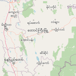
Map view of Tham Pla, Namtok Pha Suea National Park

Use this park location map to pinpoint Tham Pla, Namtok Pha Suea National Park in Thailand, understand its exact geographic position, and read its mapped placement within the surrounding landscape more clearly.

Pigeon | © OpenStreetMap contributors

Location context for Tham Pla, Namtok Pha Suea National Park

Mae Hong Son Province
Park atlas

Discover regional park geography, surrounding protected landscapes, and diverse conservation areas in northern Thailand and the Daen Lao Range.

Explore Nearby Protected Areas and National Parks Beyond Tham Pla–Namtok Pha Suea National Park
Explore additional national parks and protected areas in northern Thailand, extending your geographic discovery beyond Tham Pla–Namtok Pha Suea National Park. Compare diverse mountain parks, unique cave systems, and cascading waterfalls across the Daen Lao Range and its adjacent border regions for comprehensive atlas-style context.
National parkMae Hong Son Province

Namtok Mae Surin National Park: Protected Landscape Atlas Explorer

Mapped Boundaries and Regional Geographic Context

Access detailed information about Namtok Mae Surin National Park, a key protected area within the geographically diverse Mae Hong Son Province of Thailand. This entry focuses on the park's physical characteristics, mapped landscape, and its significance within the regional geography. Discover the protected boundaries and natural terrain that define this national park, offering a structured viewpoint for geographic exploration and atlas-based research.

Area
397 km²
Established
1981
IUCN
II
Visitors
5.5K annual
National parkChiang Mai Province

Khun Khan National Park: A Mapped Protected Landscape in Northern Thailand's Highlands

Explore its geographic boundaries and regional park context.

Khun Khan National Park is a designated national park located in the mountainous region of Chiang Mai Province, Thailand. This page provides an atlas-driven perspective, highlighting the park's mapped boundaries and its position within the broader geography of the northern Thai highlands. Users can delve into the specific protected landscape characteristics and understand its role in the regional natural terrain, offering a structured geographic discovery of this important conservation area.

Area
208 km²
Established
2012
IUCN
II
Visitors
18.1K annual
National parkChiang Mai Province

Pha Daeng National Park: National Park in Chiang Mai Province's Mountainous Geography

Mapped protected area in the Thai highlands.

Pha Daeng National Park represents a significant protected natural area within the expansive geography of Chiang Mai Province. This national park provides a clear example of mapped conservation landscapes in Northern Thailand, contributing to the region's broader geographic identity. Users can explore the park's defined boundaries and understand its role within the mountainous terrain, offering essential context for atlas-based landscape discovery.

Area
1,123 km²
Established
2000
IUCN
II
Visitors
39.5K annual
National parkMae Hong Son Province

Huai Nam Dang National Park: Northern Thailand's Mountainous Protected Landscape

Explore mapped terrain and protected area boundaries in Mae Hong Son Province.

Huai Nam Dang National Park offers a detailed look into Thailand's mountainous north, featuring rugged terrain characterized by steep slopes and deep valleys. This protected area, a key national park within Mae Hong Son Province, provides a valuable case study for understanding regional geography and landscape context. Its elevation ranges from low-lying valleys to the Doi Chang summit, contributing to its significance as a watershed and natural wilderness.

Area
1,252 km²
Established
1995
IUCN
II
Visitors
121.1K annual
National parkChom Thong District

Doi Inthanon National Park: Thailand's Highest National Park and Montane Landscape Explorer

Mapped geography and protected land context in Chom Thong District.

Doi Inthanon National Park, the crown jewel of Thailand's northern highlands, represents an unparalleled opportunity for geographic discovery. As the nation's highest mountain national park, it showcases exceptional vertical zonation of ecosystems, from tropical deciduous forests to rare cloud forests and sphagnum peat bogs. This protected landscape in Chom Thong District is vital for watershed protection and offers critical insights into Thailand's montane biodiversity, making its mapped boundaries and terrain essential for atlas-based exploration.

Area
482 km²
Established
1972
IUCN
II
Visitors
853.9K annual
National parkChiang Mai Province

Si Lanna National Park: A Protected Landscape within Chiang Mai Province

Discover its geographic context and mapped protected area identity.

Si Lanna National Park is a designated national park located in the northern Thai highlands of Chiang Mai Province. This entry provides essential geographic context, detailing the park's mapped boundaries and its place within the regional atlas. Users can explore the protected landscape's characteristics and understand its role in the diverse geography of northern Thailand, serving as a key point for atlas-driven discovery of natural areas.

Area
1,405 km²
Established
1989
IUCN
II
Visitors
89.4K annual
National parkChiang Mai Province

Op Khan National Park: A National Park in Chiang Mai Province's Mountainous Terrain

Explore protected area geography and mapped landscape context.

Op Khan National Park is situated in the diverse geography of Chiang Mai Province, a region characterized by its prominent highlands and mountainous landscapes. This page serves as a focused entry point for understanding the park's identity as a protected national park, detailing its mapped boundaries and its contribution to the regional natural landscape. Discover the geographic features and the protected-area context that define Op Khan National Park within Thailand's atlas.

Area
227 km²
Established
1992
IUCN
II
Visitors
99K annual
National parkThailand

Doi Suthep, Pui National Park: An Atlas View of Thailand's Protected National Landscape

Explore mapped boundaries and regional geographic context.

This entry focuses on Doi Suthep, Pui National Park, detailing its role as a protected national landscape within Thailand. Users can examine its mapped territory and understand its geographic placement and regional significance, offering a focused perspective for atlas exploration and a deeper appreciation of its protected status.

Area
257 km²
Established
1981
IUCN
II
Visitors
328.7K annual

Common questions about visiting, size, designation, and location context for Tham Pla, Namtok Pha Suea National Park

Tham Pla, Namtok Pha Suea National Park FAQs for park facts, access, geography, and protected area context
Find quick answers about Tham Pla, Namtok Pha Suea National Park, including protected-area facts, park geography, trail and visitor context, and how the park fits into its surrounding country and regional landscape.
MoriAtlas Explorer

Continue Your Protected Areas Search Across the Global Atlas

Deepen your exploration by continuing the structured search for national parks and protected areas worldwide. Utilize the comprehensive filtering capabilities to compare different conservation landscapes and refine your understanding of global park geography. Discover more about the distribution and characteristics of protected natural areas.

Global natural geography