
Mori Atlas logo
Nature reserveTiergarten

A historic royal hunting ground evolved into a diverse network of oak woodlands, reed beds, and riparian river corridors.

Tiergarten Nature Reserve: Mapping the Protected Landscapes and Ancient Forest Mosaic of Brandenburg

(Naturschutzgebiet Tiergarten)

The Tiergarten nature reserve stands as a significant protected area within the Dahme-Spreewald district of Brandenburg. This landscape encompasses a complex ecological mosaic, featuring ancient oak forests dating back over 270 years, wet meadows, and aquatic habitats connected by the Staabe river, the Krimnicksee, and the Krüpelsee. Originally established as a royal hunting forest, the site now serves as a protected sanctuary that blends centuries of cultural history with high-value conservation habitats, including rare alder swamps and expansive reed beds near the outskirts of Berlin.

oak forestwetland reserveNatura 2000 siteFFH siteriparian habitatwet meadows
An illustration of a natural valley featuring a tall waterfall dropping off a cliff, surrounded by a forest and a paved brick walking path in the foreground.

Tiergarten

Nature reserve

Park overview

Structured park overview, official facts, and landscape profile for Tiergarten

Tiergarten park facts, protected area profile, and essential visitor context

Review the core facts for Tiergarten, including designation, size, terrain, visitor scale, habitats, and operating context in one park-focused overview.

About Tiergarten

Tiergarten is a compact nature reserve and recreation area in the Dahme-Spreewald district of Brandenburg, Germany. It lies within the town of Königs Wusterhausen, south of Berlin and just east of the historic Wusterhausen hunting palace. The reserve wraps around the woodland core around the hamlet of Neue Mühle and stretches between the Staabe river (a branch of the Dahme) and the lake known as Krimnicksee, which connects eastwards to the Krüpelsee.

The protected area is significant because it preserves a layered landscape: an old oak-dominated forest growing on soils shaped by centuries of historical forest use, surrounded by a network of streams, lakes, wet meadows, reed beds, and alder swamp woodland. This combination of terrestrial and aquatic habitats occurs within a relatively small surface area of roughly 158 hectares, producing a habitat diversity that supports both rare woodland species and animals dependent on wetland environments.

Visitors encounter the reserve through a compact network of trails, including an approximately 1.5-kilometer forest nature trail near the meadow orchard and a longer sculpture path with wooden artworks on local legends and historical figures. Despite its proximity to the greater Berlin region, the Tiergarten functions as both an ecological refuge and a recreational green space for nearby communities, illustrating how cultural history, forest ecology, and water-based habitats can coexist in one protected landscape.

Quick facts and research context for Tiergarten

The Tiergarten is a designated nature reserve (Naturschutzgebiet) located in Königs Wusterhausen within the Dahme-Spreewald district of Brandenburg, Germany. It was formally designated as a nature reserve on 10 October 1995, with the Landesumweltamt Brandenburg (now the Landesamt für Umwelt) responsible for administration. The protected area also forms part of the European Natura 2000 network as an FFH (Flora-Fauna-Habitat) site, reflecting its broader EU-level ecological significance. Its IUCN management category is IV, indicating a habitat and species management area.

The reserve originated as a 900-hectare hunting enclosure laid out by King Friedrich Wilhelm I in 1725 east of his hunting palace at Königs Wusterhausen. The surviving core of around 100 to 158 hectares includes some of the oldest oak trees in the region, many more than two centuries old, together with alder swamps, wet meadows, and stretches of the Staabe river and the Krimnicksee lake.

Protection and recognition

Documented conservation designations and official recognition data for Tiergarten

Tiergarten Protection Status and Natura 2000 Recognition Records

Exploration of Tiergarten brings together official Natura 2000 network data and documented protection records from global conservation databases. Verified administrative sources provide structured insight into international recognition frameworks without assuming management outcomes.
Park context

Deeper park guide and search-rich context for Tiergarten

Tiergarten history, landscape, wildlife, and travel context

Explore Tiergarten through its history, landscape character, ecosystems, wildlife, conservation priorities, cultural context, and seasonal travel timing in a structured park guide built for atlas discovery and search intent.

Why Tiergarten stands out

Tiergarten is best known for its ancient oak forest, which developed from a 300-year-old royal hunting enclosure and still contains oaks over 270 years old. The reserve is also recognized for the dense ecological mosaic that surrounds this forest core: alder and ash floodplain woods, oak-hornbeam woodlands, reed beds, wet meadows, and the slow-moving waters of the Staabe river and Krimnicksee lake. These contrasting habitats, packed into a relatively small area, make it one of the more notable protected forest-wetland complexes in southern Brandenburg. Equally distinctive is the cultural overlay of the place. The Tiergarten still carries traces of its use as a royal hunting ground: pheasant and partridge enclosures, the so-called Ghost Bridge (Spukbrücke) over the historic Fanggraben, and a sculpture path with wooden figures telling the forest's legends. The combination of biological richness and inherited historical landscape is what makes the Tiergarten stand out among the small nature reserves around Berlin.
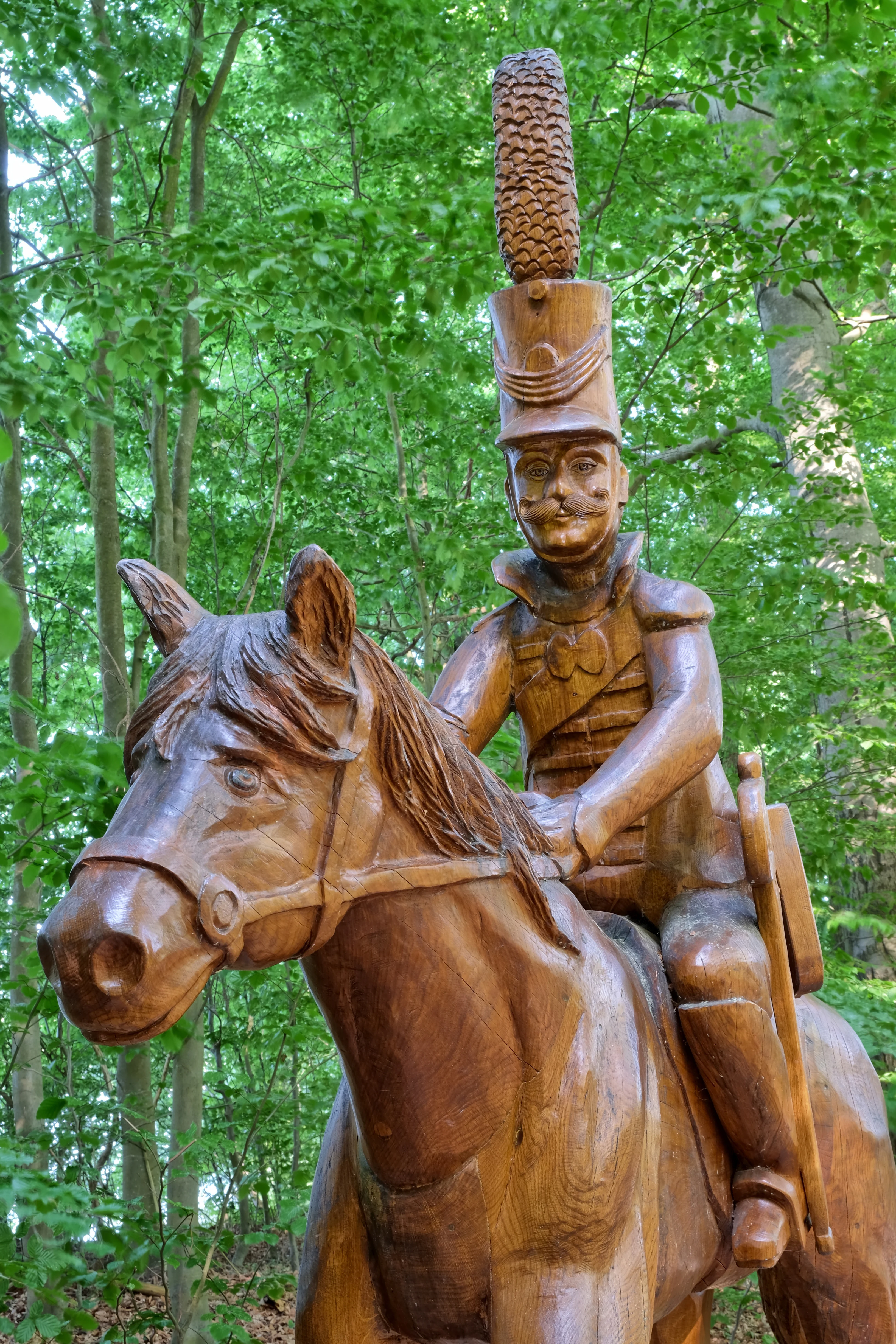
A close up view of a carved wooden statue of a hussar in a tall shako hat riding a horse, set against a background of lush green deciduous forest trees.
A wooden sculpture of a Prussian hussar on horseback located within the forest of Tiergarten.

Tiergarten history and protected-area timeline

The landscape of the Tiergarten was forged by its role as a royal hunting ground. In 1725, King Friedrich Wilhelm I of Prussia, known as the "Soldier King," established a Tiergarten of about 900 hectares east of his hunting palace at Wusterhausen. The forest was enclosed by game fences and used to keep red deer, fallow deer, and wild boar for courtly hunts. In 1749, further enclosures were added for partridges and pheasants, whose meat was intended for the king's own table during his celebrated Tabakskollegien at the palace. Until around 1800, the Tiergarten still merged directly into the palace park.

After the final enclosures were dismantled in 1918, the forest became a popular excursion destination for Berliners. In 1930, the area with its oaks, some already more than two hundred years old, was placed under nature protection for the first time, marking the beginning of a more formal conservation era. By the time the modern nature reserve was created on 10 October 1995, the surviving core of the old hunting forest had been consolidated into a coherent protected area that also absorbed surrounding meadows, lakes, and streams.

The reserve also preserves built heritage from the same period: the so-called Ghost Bridge or Devil's Bridge over the Fanggraben, an eighteenth-century crossing widened during road construction in 1889 and used as a toll bridge until 1907, is still part of the trail network. Since 2016, a sculpture path with wooden figures depicting figures and legends from the Tiergarten's past has been built up along the circular walking route, eventually reaching eleven sculptures. Together, the royal hunting origins, early twentieth-century nature-protection recognition, and modern Natura 2000 protection trace a continuous story of woodland stewardship in southern Brandenburg.

Tiergarten landscape and geographic character

The landscape of the Tiergarten is shaped by the interplay between old forest and water. Its heart is an oak-dominated woodland, where ancient pedunculate oaks, some more than 270 years old, stand over soils and microtopography shaped by centuries of forest use. The woodland ridge lies on the southern shore of the Staabe and along the western shore of the Krimnicksee, and descends eastwards through the Staabe-Dahme confluence into the marshy edges of the Krüpelsee.

Water defines the character of much of the reserve. The Staabe, a branch of the Dahme river, winds along the northern edge of the forest, while quieter stretches of the Krimnicksee and Krüpelsee open the area to the east. Smaller elements add further variety: the Krebssee and the Fanggraben, a drainage channel that once linked the Zeesener See through the Senziger Luch down to the Dahme, create networks of ponds, reed beds, and damp ditches. Streuobstwiesen, traditional orchard meadows, occupy some of the open ground in the western part of the area.

Within this compact setting, the relief shifts gently between dry oak-covered slopes, soft wet meadows, low alder carrs, and open water surfaces. Walking trails, including an Uferweg along the shore of the Staabe, the circular sculpture trail, and the shorter forest nature trail, expose visitors to this sequence of forest and wetland landscapes within a few kilometers of walking.
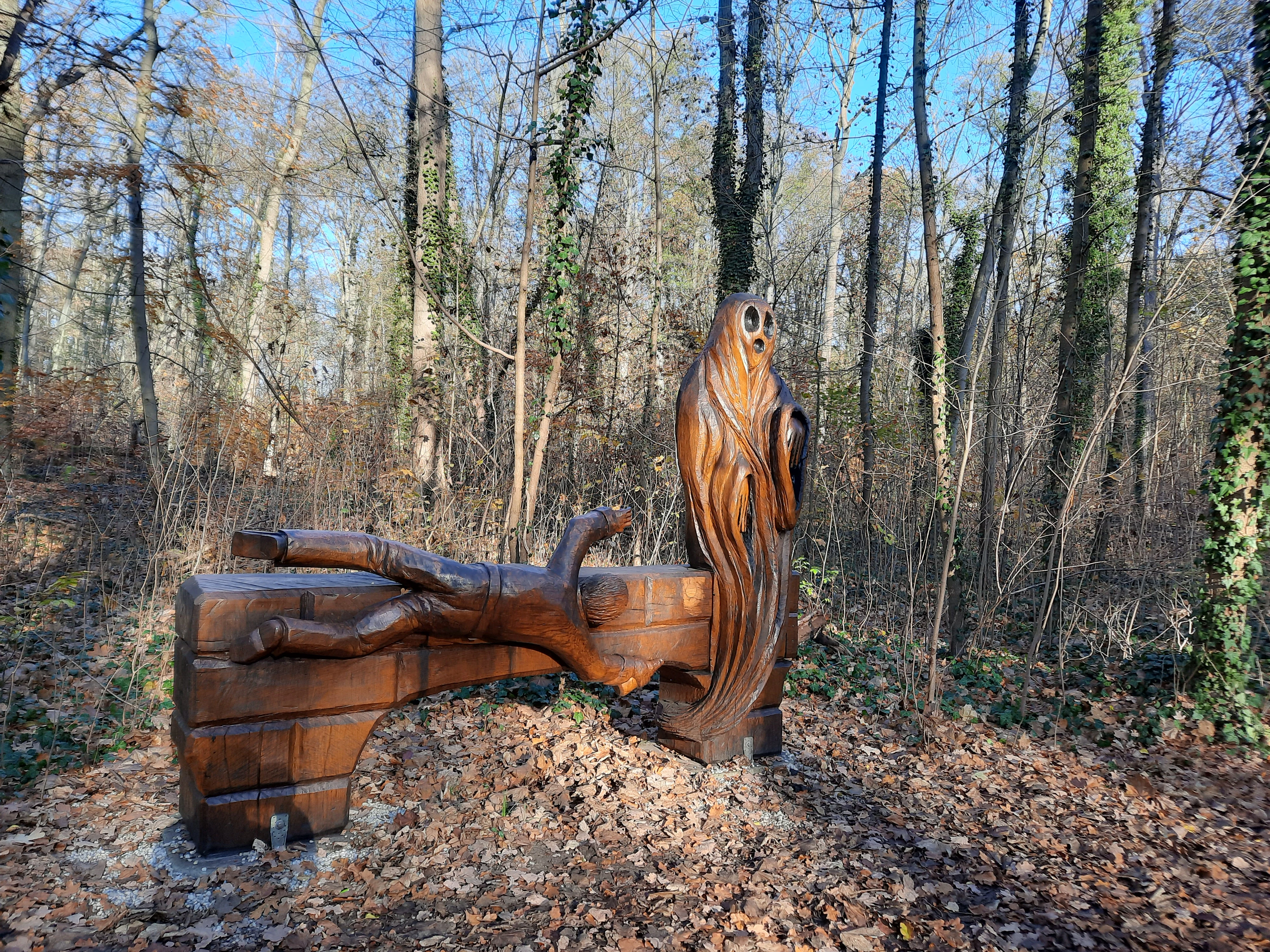
A brown wooden sculpture resembling a draped ghost or figure carved into a block, set in a wooded area with many bare trees and dry leaves on the ground.
A wooden sculpture carved into the form of a ghost, located along a path in the Tiergarten Neue Mühle nature reserve.

Tiergarten ecosystems, habitats, and plant life

The Tiergarten's ecosystems form a dense, intertwined mosaic. The Natura 2000 habitat types recorded for the site include old acidophilous oak woods on sandy soils with birch and pedunculate oak, Stellario-Carpinetum oak-hornbeam forests, Luzulo-Fagetum beech forest, and wet woodland communities such as alder-ash and alder swamp forests. Surrounding the forest core are Molinia meadows (Pfeifengraswiesen), tall-herb wet fringes along the streams and lakes, and natural or near-natural nutrient-rich still waters fringed with pondweed or frogbit communities. Slow-flowing stretches of the Staabe and Fanggraben support submerged aquatic vegetation along their length.

Together, these habitats give the reserve a strong ecological gradient from dry, light oak forest to permanently waterlogged wetland and open water conditions within a small radius. Open orchard meadows, or Streuobstwiesen, introduce additional transitional habitat where woodland meets meadow. This high habitat diversity, rather than any single habitat type, is what gives the Tiergarten its ecological character and importance for the broader Dahme lake landscape.
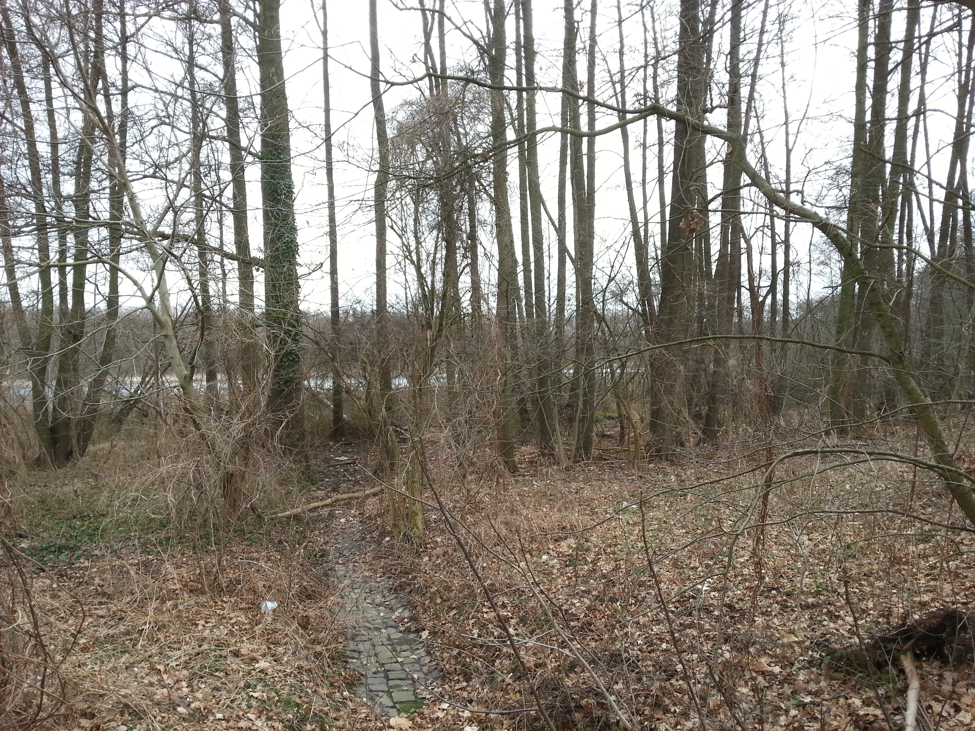
A view through dense leafless trees toward the Krebssee water surface in the Tiergarten nature reserve.
A view of the woodland area near Krebssee within the Tiergarten nature reserve.

Tiergarten wildlife and species highlights

Wildlife in the Tiergarten benefits from the close coexistence of forest, wetland, and aquatic habitats. The varied woodland structure, with ancient oaks and a long continuity of old trees, provides nesting and roosting opportunities for cavity-nesting birds and for bats that depend on near-natural forest complexes. Reed beds, wet meadows, and the slow-moving rivers and lakes create conditions favored by rails and other moisture-dependent bird species, while the interface between woodland and open habitat supports large moth species that require such transitional environments.

The reserve's protection regulations explicitly highlight aquatic mammals and reptiles, as well as bats, cavity nesters, rails, and large butterflies, groups that depend on the mosaic of habitats preserved there. In the aquatic environment, two species stand out in the formal protection documents: the European otter, which uses the rivers and lakes of the Dahme system, and the bitterling, a small freshwater fish that lives in the slower-flowing waters. Wetland-dependent fauna on land, from amphibians to marshland birds, finds refuge in the reed beds and wet meadows around the Krimnicksee, Krebssee, and Fanggraben.
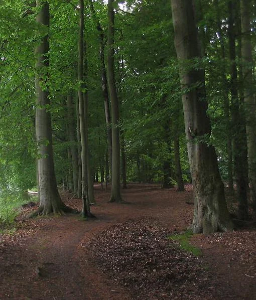
A dirt trail winds through a forest of tall, mature trees with dark trunks and a lush green canopy, with the ground covered in brown fallen leaves.
A shaded path winds through the dense, mature tree stand of the Tiergarten nature reserve in Brandenburg.

Tiergarten conservation status and protection priorities

The Tiergarten is conserved on multiple overlapping levels. In Brandenburg, it has been protected as a Naturschutzgebiet since 10 October 1995, with management responsibility resting with the state's environment office through its ecology, nature protection, and water division. At the European level, the area is part of the Natura 2000 network as an FFH site, contributing to the coherent ecological network of protected habitats across the European Union and linking the Dahme waters to the Pätzer Seen.

The stated conservation purpose of the reserve is the preservation and development of a wide variety of near-natural forest communities, including features shaped by the site's long history of use. The protection ordinance also singles out large reed beds, alder and willow carrs in the low-lying wetlands, near-natural flowing waters such as the Fanggraben with their characteristic bank vegetation, and the broader mosaic of wet meadows. A particular focus is placed on threatened aquatic mammals and reptiles, on bats that require old forest structures, and on large butterflies that need woodland-open-land transitions, all of which are reasons the site is classified as IUCN Category IV, a habitat and species management area.

Additional conservation work aims to revitalize wet meadows that have been impaired by agricultural pressure, over-use, or abandonment, and to improve the coherence of the biotope network connecting the Dahme waters to the Pätzer Seen. This combination of statutory protection, targeted habitat management, and integration into wider ecological corridors gives the Tiergarten a clear conservation role at the regional and EU scale.

Tiergarten cultural meaning and human context

The cultural identity of the Tiergarten is inseparable from Prussian royal hunting and palace life. The forest was laid out as a 900-hectare hunting enclosure by Friedrich Wilhelm I, and the meat it produced was served at the Tabakskollegien, the famous tobacco-and-talk gatherings held at the Wusterhausen palace. The presence of a dedicated pheasant and partridge enclosure from 1749 shows how thoroughly the site was woven into court life.

Local memory still reads the landscape as a place of stories. The eighteenth-century bridge over the Fanggraben has been known for generations as the Ghost Bridge (Spukbrücke) or Devil's Bridge (Teufelsbrücke), told to be haunted at midnight or by the ghost of a man who drowned in the ditch. Since 2016, a sculpture path through the Tiergarten has retold these stories and historic figures in wooden form, from the tall Langer Kerl commemorating Friedrich Wilhelm I to works depicting hunters, fishermen, ferrymen, and the king with his miller. This cultural layer, combined with a forest nature trail that interprets the local flora and fauna, makes the Tiergarten an equally important place for regional heritage and traditional outdoor recreation.

Top sights and standout views in Tiergarten

The Tiergarten brings together, in a small Brandenburg reserve, ancient oaks more than 270 years old, a stretch of the Staabe river, and quiet lakes such as the Krimnicksee and Krebssee. It is one of the older formally protected forests in the Dahme-Spreewald district, first placed under nature protection in 1930 and re-designated as a Naturschutzgebiet in 1995, and now part of the European Natura 2000 network.

Visitors can follow a short forest nature trail near the orchard meadow to learn about regional flora and fauna, walk the longer Uferweg along the Staabe, or complete the 7.5-kilometer sculpture path with its carved wooden figures. Historic features like the eighteenth-century Ghost Bridge over the Fanggraben, and the landscape echoes of the old royal hunting forest, add a distinctive cultural depth to a reserve otherwise defined by its forest, meadow, and wetland mosaic.

Best time to visit Tiergarten

The Tiergarten is best experienced in late spring and early summer, when woodland wildflowers, tall herb fringes, and wet meadow vegetation are at their most expressive, and when bird activity in reed beds and forest canopy is high. Early morning hours in this season are particularly rewarding for observing wetland-dependent birds along the Staabe and around the Krimnicksee, and for hearing the forest come alive with sound.

Autumn offers a different character, with mature oaks dropping mast and the forest floor taking on colorful leaf litter, while the cool-season light emphasizes the texture of old trunks and open water. Winter, though quieter, still rewards walking: bare canopies reveal the long continuity of the woodland, the open lakes and reed beds are easier to view, and frost often sharpens the outlines of the Ghost Bridge and the sculpture path. In each season, the compact size of the reserve means that a single walk can reveal forest, water, meadow, and cultural landmarks.

Monthly climate preview

Long-term representative measurements for regional Brandenburg geography

Tiergarten Climate Normals, Annual Temperature and Precipitation Rhythm

Historical monitoring records reveal a structured annual progression of average temperatures and monthly precipitation rates across the Tiergarten coordinate. Exploring the complete twelve-month climate profile provides detailed context on long-term weather patterns and thermal ranges.
Annual mean9 °C
-1 °C20 °C
Jan-1°
Feb
Mar
Apr
May14°
Jun18°
Jul20°
Aug20°
Sep15°
Oct
Nov
Dec
Warmest month
July

20.3 °C

Coolest month
January

-0.9 °C

Wettest month
July

2.4 mm/day

Driest month
April

1.1 mm/day

Park location guide

Geography guide, regional context, and park location map for Tiergarten

Tiergarten park geography, regions, and map view in Germany

Understand where Tiergarten sits in Germany through a broader geographic reading of the surrounding landscape, nearby location context, and its mapped position within the national park landscape.

How Tiergarten fits into Germany

Germany is a federal republic in Western and Central Europe with a population of over 83 million across sixteen constituent states. It is Europe's largest economy by nominal GDP and a major global exporter and importer. The capital is Berlin, and the country borders Denmark, Poland, Czech Republic, Austria, Switzerland, France, Luxembourg, Belgium, and the Netherlands.

Wider geography shaping Tiergarten in Germany

Germany is located in Western and Central Europe, spanning 357,022 km². It borders Denmark to the north, Poland and the Czech Republic to the east, Austria and Switzerland to the south, and France, Luxembourg, Belgium, and the Netherlands to the west. The country has coastlines on the Baltic Sea and North Sea to the north, with the Alps located in the southern region.

Map view of Tiergarten

Use this park location map to pinpoint Tiergarten in Germany, understand its exact geographic position, and read its mapped placement within the surrounding landscape more clearly.

Pigeon | © OpenStreetMap contributors

Location context for Tiergarten

Brandenburg

Explore detailed imagery of ancient oak stands, river edges, and rare wetland habitats across the reserve.

Tiergarten Photos and Protected Landscape Scenery: Visualizing the Ancient Forest and Wetland Reserve

Visual documentation reveals the intricate ecological mosaic of ancient oak forests, quiet river corridors, and protected wetland habitats that define the reserve. Examining these landscape views provides a deeper understanding of the protected terrain, terrain contours, and environmental character preserved within the Brandenburg region.

A close up view of a carved wooden statue of a hussar in a tall shako hat riding a horse, set against a background of lush green deciduous forest trees.

A carved wooden statue of a man in 18th-century military attire, standing on a round wooden base in a forest. To the right, an information sign on a metal post is visible.

A brown wooden sculpture resembling a draped ghost or figure carved into a block, set in a wooded area with many bare trees and dry leaves on the ground.

A view through dense leafless trees toward the Krebssee water surface in the Tiergarten nature reserve.

A dirt trail winds through a forest of tall, mature trees with dark trunks and a lush green canopy, with the ground covered in brown fallen leaves.

A wide view of a dormant meadow with scattered deciduous trees, a small wooden picnic structure, and a forest line in the background under an overcast sky.

Park atlas

Compare adjacent woodland reserves, wetland habitats, and regional river landscapes.

Exploring Parks Near Tiergarten and Surrounding Brandenburg Protected Areas

Browsing other protected areas near Tiergarten reveals a broader network of ancient forests, river valleys, and wetland ecosystems across southern Brandenburg. Comparing adjacent conservation sites helps place the historic oak reserve within the wider ecological context of the Dahme Spreewald region.
A horizontal watercolor illustration depicting a soft, serene landscape with green trees, pink flowering trees, and gentle hills on a white background.
Nature reserveBrandenburg
3.9 km away#1 closest

East

Skabyer Torfgraben Nature Reserve: Geographic Mapping and Protected Area Overview

Wetland landscape corridors within Brandenburg, Germany

The Skabyer Torfgraben nature reserve provides a focused look at lowland stream ecosystems and rare through-flow peatland remnants. This protected area in the Dahme-Spreewald region serves as a crucial habitat mosaic, blending sandy birch-oak forests with sedge-dominated wet meadows. Examine its natural terrain and hydrological connections to the Dahme river within the context of German protected landscapes.

Area
3.049 km²
Established
1998
IUCN
IV
Relief
Lowland
Nature reserveSchleswig-Holstein
About 5.3 km away#2 closest

Northwest

FFH-Gebiet Wellspanger-Loiter-Oxbek-System und angrenzende Wälder Protected Landscapes

Schleswig-Holstein nature reserve map and geography

This protected area bundles a wide range of priority habitat types, including calcareous springs, inland dunes, and old-growth beech forests. Spanning the Angeln peninsula, the site protects a hydrological backbone of stream systems and rare wet meadows that remain critical for regional biodiversity in Northern Germany.

Area
14.34 km²
Established
2004
Relief
Upland
Climate
Temperate
Nature reserveBrandenburg
6.1 km away#3 closest

Southeast

Dolgensee Nature Reserve: Mapped Protected Landscapes and Wetland Geography in Brandenburg, Germany

Protected lake basin, reedbeds, and inland dune grassland

Located in the Brandenburg state of Germany, Dolgensee Nature Reserve offers a rare mosaic of wetland and dry grassland habitats. The site centers on a nutrient-rich lake basin featuring extensive reedbeds and alder swamp, which transitions into open inland dune ecosystems. This protected area represents a significant example of natural lake basin preservation within the larger Dahme-Heideseen landscape, providing a crucial habitat for various waterbird and aquatic wildlife species.

Area
3.085 km²
Established
1995
IUCN
IV
Relief
Lowland
A soft watercolor illustration of a lowland wetland landscape with a small pool of water, grasses, and scattered trees under a light sky.
Nature reserveBrandenburg
About 8.1 km away#4 closest

Northwest

Flutgrabenaue Waltersdorf Nature Reserve: Protected Wetland Geography and Regional Atlas

A significant floodplain sanctuary in the Brandenburg lowlands.

Flutgrabenaue Waltersdorf represents an ecologically rich lowland floodplain featuring sinuous watercourses, alder swamps, and traditional meadow habitats. Located south of Berlin, this reserve provides a vital geographic contrast to the urbanized infrastructure of the Brandenburg region. Use this overview to study the boundary, terrain characteristics, and regional importance of this protected marshland landscape.

Area
2.88 km²
Established
1998
IUCN
IV
Relief
Lowland
A wide watercolor illustration showing a calm lake with small tree-covered islands, bordered by green forests and distant hills under a pale sky.
Protected areaBrandenburg
9.3 km away#5 closest

North

Wernsdorfer See Protected Area: Geographic Mapping and Landscape Context in Brandenburg

Glacial wetland mosaic featuring dunes and reedbeds

Wernsdorfer See is an essential nature reserve in Brandenburg that showcases a rare mix of habitats, from open sandy dunes and grasslands to shallow marshland and reedbeds. Managed as part of the Natura 2000 network, the site serves as a vital refuge for bird species and rare wetland flora. This overview traces the geography and terrain of the Spree valley lowland, offering a structured perspective on its conservation landscape.

Area
1.387 km²
Established
1967
Relief
Lowland
Climate
Temperate
Nature reserveBrandenburg
10 km away#6 closest

South

Töpchiner Seen Nature Reserve: Geographic Overview of Brandenburg Protected Landscapes

A glacial landscape mosaic of lakes, fens, and woodlands

Located in the Dahme-Spreewald district, Töpchiner Seen is a vital nature reserve showcasing deep peat deposits and diverse wetland vegetation. The protected area features a layered terrain, where open water connects to transition mires, calcareous meadows, and mature oak and pine forests, providing a stable habitat for specialized flora and fauna within the broader Brandenburg geography.

Area
3.75 km²
Established
1988
Nature reserveBrandenburg
11 km away#7 closest

Southeast

Katzenberge Nature Reserve: An Atlas of Glacial Moraine Woodlands in Brandenburg Germany

Protected oak forest habitats within the Dahme-Spreewald landscape

Katzenberge offers a focused look at the conservation of mature deciduous forest environments on sandy moraine soils. As a designated nature reserve within the Brandenburg region, the area serves as a primary reference point for studying habitat continuity and the unique glacial terrain that defines the south-eastern lowlands near the Dahme river.

Area
1.44 km²
Established
2004
IUCN
IV
Relief
Upland
A watercolor painting showing a soft, abstract landscape with rolling hills, a central body of water, and a tree-lined shoreline.
Nature reserveBerlin
11 km away#8 closest

North

Krumme Lake Nature Reserve: Geographic Overview and Protected Wetland Boundaries in Berlin

A preserved mosaic of alder swamp forest and Dahme floodplain habitat

Krumme Lake preserves a dense network of wetland habitats within the pine-dominated forests of Berlin's Treptow-Köpenick borough. This protected nature reserve integrates groundwater-influenced ecosystems and riparian forest remnants, providing a sanctuary for diverse amphibians and invertebrates that have become increasingly rare in surrounding urbanized landscapes.

Area
0.452 km²
Established
2004
IUCN
IV
Relief
Lowland

Common questions about visiting, size, designation, and location context for Tiergarten

Tiergarten FAQs for park facts, access, geography, and protected area context

Find quick answers about Tiergarten, including protected-area facts, park geography, trail and visitor context, and how the park fits into its surrounding country and regional landscape.
MoriAtlas Explorer

Continue Your Protected Areas Search Across the Global Atlas

Deepen your exploration by continuing the structured search for national parks and protected areas worldwide. Utilize the comprehensive filtering capabilities to compare different conservation landscapes and refine your understanding of global park geography. Discover more about the distribution and characteristics of protected natural areas.

Global natural geography