
Mori Atlas logo
Nature reserveTorfowiska Orawsko-Nowotarskie

A significant peatland complex within the intermontane basins of southern Poland.

Torfowiska Orawsko-Nowotarskie Nature Reserve: Mapped Protected Landscapes and Bog Geography

Torfowiska Orawsko-Nowotarskie represents a critical peatland conservation site situated within the Kotlina Orawsko-Nowotarska basin of southern Poland. This protected landscape is defined by its extensive mosaic of raised bogs, transitional mires, and boggy coniferous forests that formed in the post-glacial environment of the Carpathian foothills. The area serves as a vital refuge for specialized bird species and unique plant communities dependent on its saturated, nutrient-poor terrain.

peatlandraised bogNatura 2000Kotlina Orawsko-NowotarskaCarpathian foothillsbog forest
A flat-style digital illustration showing a foreground of rolling green grassy meadows, a middle ground of dense forest, and a jagged, snow-capped mountain range in the background under a pale yellow sky.

Torfowiska Orawsko-Nowotarskie

Nature reserve

Park overview

Structured park overview, official facts, and landscape profile for Torfowiska Orawsko-Nowotarskie

Torfowiska Orawsko-Nowotarskie park facts, protected area profile, and essential visitor context

Review the core facts for Torfowiska Orawsko-Nowotarskie, including designation, size, terrain, visitor scale, habitats, and operating context in one park-focused overview.

About Torfowiska Orawsko-Nowotarskie

Torfowiska Orawsko-Nowotarskie represents a formally integrated Natura 2000 territory in which habitat protection and bird protection overlap across the Kotlina Orawsko-Nowotarska. The site covers peatlands, wetlands, and relevant surrounding habitats in the intermontane basin of the Orawa and Nowy Targ regions, spanning parts of the gminas Czarny Dunajec, Jabłonka, and Nowy Targ, including the town of Nowy Targ itself in Małopolskie voivodeship.

The defining environmental story of this area is geological. The basin formed in the Neogene as the land sagged between surrounding mountain ranges, and during the last glaciation it received a thick layer of poorly permeable loam deflated from the Carpathian flysch of the surrounding Beskidy and Podhale. As the ice retreated, the resulting flat, often waterlogged terrain filled with shallow pools and wet depressions. Over thousands of years, the gradual accumulation of plant material, especially sphagnum mosses, transformed these wet hollows into a network of peatlands, locally known historically as pustacie or puszciny.

The basin climate is particularly favorable for peat formation. Precipitation exceeds evaporation, the surrounding mountains deliver abundant meltwater and snowmelt, and even during prolonged droughts the soil retains enough moisture to support active high bog development. Today, the site encompasses a wide spectrum of protected peatland and wetland habitat types, including active raised bogs with living peat-forming vegetation, degraded raised bogs capable of regeneration, transition mires and quaking bogs, base-rich mountain flushes dominated by sedges and mosses, boggy coniferous and birch forests, and willow-poplar-ash floodplain forests along mountain streams. Together, these habitats form a continuous ecological gradient from open waterlogged bog to boggy woodland.

Beyond its habitat value, the site is significant because centuries of human use have shaped and partly damaged the peatlands. Local communities once harvested peat for fuel, gardening, forestry, and insulation. Mid-twentieth-century industrial extraction accelerated peatland decline until, in 1994, peat was legally classified as a mineral in Poland, restricting its exploitation to licensed operations. Today only Puścizna Wielka remains as a site of legal peat extraction within the broader Kotlina Nowotarska, while the rest of the catchment falls into a protected regime. This history of use and recovery is central to the modern conservation identity of Torfowiska Orawsko-Nowotarskie.

Quick facts and research context for Torfowiska Orawsko-Nowotarskie

Torfowiska Orawsko-Nowotarskie is a Natura 2000 site designated both as a special area of habitat conservation and a special protection area for birds, combined in a single declared area in 2022. The site lies in the Kotlina Orawsko-Nowotarska, within the Małopolskie voivodeship of southern Poland, and covers a substantial area of more than 8,000 hectares across the Nowy Targ powiat.

The protected territory includes part of the Bór na Czerwonem nature reserve, established in the 1920s and re-established in the 1950s, and overlaps with the larger Południowomałopolski Obszar Chronionego Krajobrazu, which has protected the broader landscape since 1997. The site is designated under the European Natura 2000 framework and protects peatland habitat types, bog-dependent forest, mountain stream vegetation, and a set of rare bird and animal species of EU conservation concern.

Protection and recognition

Documented terrestrial protection scope, designation history, and international source records

Torfowiska Orawsko-Nowotarskie Protection Status and Natura 2000 Recognition

Torfowiska Orawsko-Nowotarskie maintains documented terrestrial protection status established in 2022 alongside official Natura 2000 recognition sources. Official designation records detail the management scope and verified international framework assignments for this protected landscape.
Park context

Deeper park guide and search-rich context for Torfowiska Orawsko-Nowotarskie

Torfowiska Orawsko-Nowotarskie history, landscape, wildlife, and travel context

Explore Torfowiska Orawsko-Nowotarskie through its history, landscape character, ecosystems, wildlife, conservation priorities, cultural context, and seasonal travel timing in a structured park guide built for atlas discovery and search intent.

Why Torfowiska Orawsko-Nowotarskie stands out

Torfowiska Orawsko-Nowotarskie is best known for its exceptional concentration of raised peat bogs and associated bog forests, which together form one of the most significant peatland complexes in the Polish Carpathians. The dome-shaped high bogs, transitional mires, and bog pine woodlands shape an unusual and ecologically rich landscape that stands out even within a region already defined by wetlands. The site is also recognized for the birdlife that depends on this mosaic of open bog, marsh, wet meadow, and adjacent forest. Rare and legally protected species associated with the area have made it an important reference point for peatland conservation and Natura 2000 habitat protection in Poland.
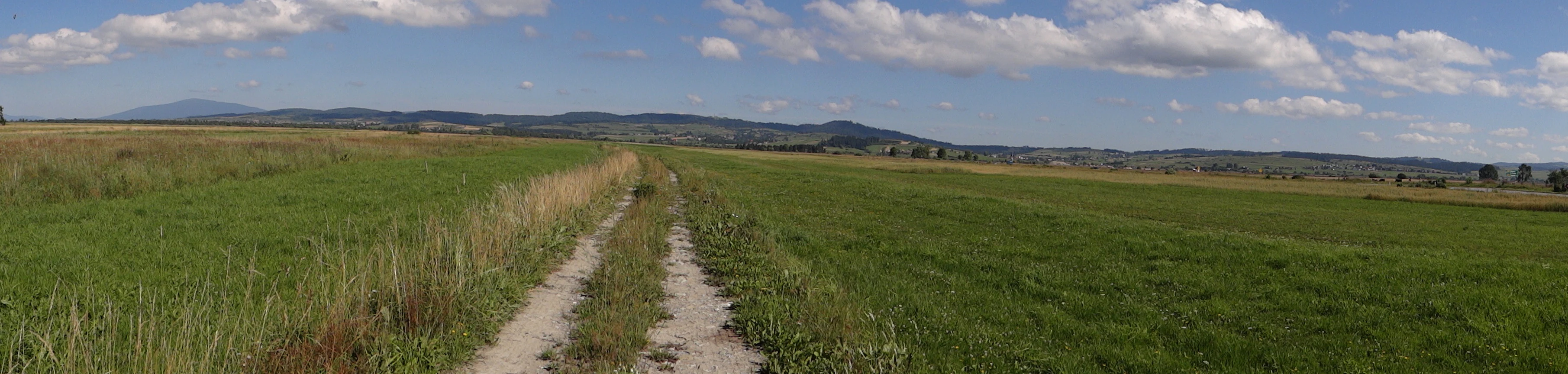
A wide panoramic view of a flat, grassy landscape with a dirt road stretching into the distance towards rolling hills and mountains under a partly cloudy blue sky.
A dirt trail winds through the expansive fields of the Nowy Targ Basin, surrounded by the Orava Highlands and the Beskid mountains.

Torfowiska Orawsko-Nowotarskie history and protected-area timeline

The peatlands of the Kotlina Nowotarska have a long human history as a resource. Surrounding communities traditionally cut peat, dried it, and used it as fuel, later also as a horticultural and forestry substrate and as insulation material. From the mid-twentieth century, peat began to be harvested industrially, causing substantial damage to the bog systems. In 1994, Poland legally classified peat as a mineral, restricting extraction to operations holding a proper concession, which became a key turning point for peatland protection in the region.

Formal conservation of the broader landscape began with the Południowomałopolski Obszar Chronionego Krajobrazu, which has covered the area since 1997. Within this wider protected landscape lies the Bór na Czerwonem nature reserve, first established in 1925 and re-established in 1956, considered one of the classic bog forest reserves of the Polish Carpathians.

The Natura 2000 process added a European dimension. The site was proposed in April 2004 as a special area of habitat conservation covering about 8,255 hectares in Małopolskie voivodeship, and on 25 January 2008 it was confirmed by the European Commission as a site of Community importance under the Habitats Directive. A separate Special Protection Area for birds, PLB120007, was established in 2007 across broadly overlapping boundaries. In 2022 the area was finalized in its present form, integrating both habitat and bird protection within a single Natura 2000 designation.

Torfowiska Orawsko-Nowotarskie landscape and geographic character

The landscape of Torfowiska Orawsko-Nowotarskie is defined by a wide, flat intermontane basin framed by the Beskidy mountain ranges and the Podhale highlands. Tectonic subsidence during the Neogene produced the broad depression, and a Quaternary cover of deflated Carpathian loam sealed the basin floor, producing the waterlogged conditions that allowed bogs to form.

Visually, the area is dominated by open, dome-shaped raised bogs interspersed with wet meadows, marshy depressions, slow-flowing streams, and boggy patches of stunted pine and birch forest. Mountain stream corridors cut through the basin, depositing gravel terraces that support distinctive pioneer vegetation. Because peat accumulation has raised the bog surfaces above the surrounding mineral substrate, the terrain often has an unusually undulating appearance: rounded hummocks alternating with wet hollows, pools, and saturated margins.

The surrounding hills of the Carpathian flysch give the basin a sheltered microclimate, intensifying fog, frost, and snow cover. In combination with high precipitation and snowmelt runoff, this produces the cool, consistently moist conditions that drive ongoing peat formation. Across the wider Kotlina Nowotarska, the result is a striking contrast between the green, waterlogged plain of the peatlands and the wooded ridges rising around it.

Torfowiska Orawsko-Nowotarskie ecosystems, habitats, and plant life

Torfowiska Orawsko-Nowotarskie protects one of the most habitat-rich Natura 2000 site complexes in southern Poland, with twelve habitat types listed as subject to protection. The protected spectrum covers active raised bogs with living peat-forming vegetation, degraded raised bogs capable of natural or assisted regeneration, transition mires and quaking bogs, base-rich flushes and sedge-moss mires, and boggy boreal-style pine and birch forests that fringe the open peat surfaces.

Along the mountain streams that traverse the basin, the site protects pioneer vegetation on river gravels, willow and bayberry shrub communities, and various willow-poplar-ash floodplain forests, including spring-fed alder stands. Beyond the strict peatlands, the territory also includes species-rich Nardus grasslands on upland margins and extensively used mountain hay meadows of the Polygono-Trisetion type, which maintain the open, semi-natural character of the surrounding basin landscape.

Together these habitats form an ecological continuum from wet, acidic bog surfaces through minerotrophic mires to bog forests and upland meadows. This gradient is ecologically unusual at a European scale, and it underpins the site's ability to support a wide range of specialized bog, mire, and forest-dependent species.

Torfowiska Orawsko-Nowotarskie wildlife and species highlights

Although the site is most often discussed in terms of habitats, its fauna is a major reason for its international protection status. The site lists four bird species of EU conservation concern as specific subjects of protection. These include the lesser spotted eagle, the corncrake, the black grouse, and the western capercaillie, each of which depends on the complex mosaic of open peatland, wet meadow, and surrounding bog forest that the site provides.

The non-avian fauna protected under the site includes the yellow-bellied toad and the Carpathian newt, both amphibians closely tied to dynamic water bodies and wet depressions across the basin. Two species of microscopic terrestrial snails of European conservation importance are also listed: Vertigo angustior and Vertigo geyeri, both characteristic of calcareous and transitional mires. The thick-shelled river mussel, a freshwater bivalve of high conservation concern, is also listed as a protected species for the area.

Taken together, the protected species profile confirms the site as a key area for bog, mire, and bog-forest fauna in the Polish Carpathians, with strong relevance for both European bird and habitat directives.

Torfowiska Orawsko-Nowotarskie conservation status and protection priorities

Torfowiska Orawsko-Nowotarskie is a cornerstone Natura 2000 site in the Polish Carpathians, recognized for the conservation value of both its habitats and its birdlife. Its formal designation integrates a Special Area of Habitat Conservation and a Special Protection Area for birds within a single protected territory, giving the site high legal protection under the European ecological network.

The conservation importance of the area rests on the rarity and vulnerability of raised bog ecosystems in Central Europe. Active raised bogs, which are still accumulating peat through living Sphagnum communities, are among the most threatened habitat types in the European Union, and their protection here is significant for climate-relevant carbon storage, hydrological regulation, and biodiversity. The site's combination of protected high bogs, regenerable degraded bogs, transitional mires, bog forests, mountain stream corridors, and upland meadows gives the area a buffered ecological structure that supports long-term habitat resilience.

Locally, the site functions within a layered protection framework that already includes the long-established Bór na Czerwonem reserve and the surrounding Południowomałopolski Obszar Chronionego Krajobrazu. The Natura 2000 designation adds European-level recognition and stricter controls on activities that could harm peatland processes, particularly peat extraction and inappropriate drainage. As a result, Torfowiska Orawsko-Nowotarskie is widely regarded as one of the most important peatland conservation anchors in southern Poland.

Torfowiska Orawsko-Nowotarskie cultural meaning and human context

Peat has been part of the material culture of the Kotlina Nowotarska and Orawa regions for generations. Local communities used dried peat for heating and cooking, and later adopted it as a horticultural substrate and insulation material. The traditional names pustacie and puszciny, applied locally to these peatlands, reflect a long-standing indigenous recognition of the bogs as distinct, somewhat forbidding landscapes.

The areas surrounding the peatlands have a distinctly highland Carpathian cultural identity, blending Podhale traditions from the Tatra foreland with Orawa regional character further west. Today, the Natura 2000 status of the site interacts with rural land use, traditional hay meadow management, and grazing practices that have long shaped the basin's open landscapes. The conservation regime is therefore not only about protecting untouched bog but also about sustaining the cultural-agricultural landscape mosaic that surrounds and supports the peatland system.

Top sights and standout views in Torfowiska Orawsko-Nowotarskie

Torfowiska Orawsko-Nowotarskie stands out as one of the most comprehensive peatland conservation sites in the Polish Carpathians, bringing together active raised bogs, regenerable degraded bogs, and supporting bog forest and stream habitats within a single Natura 2000 designation. Its overlapping habitat and bird protection status gives it unusual legal strength for a peatland complex.

The site is anchored by the historically important Bór na Czerwonem reserve and embedded within the broader Południowomałopolski Obszar Chronionego Krajobrazu, situating it within a layered regional and European protection framework. Its association with legally protected bird species including lesser spotted eagle, black grouse, and capercaillie, alongside bog-dependent amphibians and invertebrates, gives the area a distinctive conservation profile unusual for an inland Polish basin.

Best time to visit Torfowiska Orawsko-Nowotarskie

The peatlands of the Kotlina Orawsko-Nowotarska are accessible across much of the year and change character with the seasons. Late spring and early summer tend to be the most active period for birdlife and amphibians, when wet meadows and open bogs are at their most biologically expressive and the surrounding Carpathian slopes are green.

Late summer and early autumn often produce atmospheric conditions worth noting: cooler temperatures, lower water levels, and the warmest, most stable weather for exploring the basin on foot, though fog and damp conditions are frequent because of the basin's microclimate. Winter brings snow cover that emphasizes the contrast between white fields, dark conifer stands around the bogs, and the surrounding ridges of the Beskidy, while freeze-hardened surfaces allow safer cross-country route choices within the generally soft and wet terrain.


Monthly climate preview

Long-term representative temperature ranges and monthly precipitation rhythm

Torfowiska Orawsko-Nowotarskie Climate Normals and Annual Weather Patterns

Historical NASA measurements record a distinct annual rhythm of sub-zero winter minimums and warm summer peaks across representative terrain coordinates at Torfowiska Orawsko-Nowotarskie. Examining the complete monthly temperature and precipitation profile provides deeper insight into long-term climate normals.
Annual mean6 °C
-5 °C17 °C
Jan-5°
Feb-4°
Mar
Apr
May11°
Jun15°
Jul17°
Aug17°
Sep12°
Oct
Nov
Dec-4°
Warmest month
July

16.7 °C

Coolest month
January

-4.9 °C

Wettest month
July

4.4 mm/day

Driest month
December

1.7 mm/day

Park location guide

Geography guide, regional context, and park location map for Torfowiska Orawsko-Nowotarskie

Torfowiska Orawsko-Nowotarskie park geography, regions, and map view in Poland

Understand where Torfowiska Orawsko-Nowotarskie sits in Poland through a broader geographic reading of the surrounding landscape, nearby location context, and its mapped position within the national park landscape.

How Torfowiska Orawsko-Nowotarskie fits into Poland

Poland, officially the Republic of Poland, is a Central European country spanning from the Baltic Sea in the north to the Carpathian Mountains in the south. It borders Germany, Czech Republic, Slovakia, Ukraine, Belarus, Lithuania, and Kaliningrad Oblast. The country has a temperate climate, diverse landscapes, and is known for its rich history, cultural heritage, and strong economic position within the EU.

Wider geography shaping Torfowiska Orawsko-Nowotarskie in Poland

Poland occupies 312,696 km2 in Central Europe, extending from the Baltic Sea coast in the north to the Sudetes and Carpathian Mountains in the south. It borders Germany to the west, Czech Republic and Slovakia to the south, Ukraine and Belarus to the east, and Lithuania and Kaliningrad Oblast to the northeast. The landscape includes lowland plains, uplands, and mountain ranges.

Map view of Torfowiska Orawsko-Nowotarskie

Use this park location map to pinpoint Torfowiska Orawsko-Nowotarskie in Poland, understand its exact geographic position, and read its mapped placement within the surrounding landscape more clearly.

Pigeon | © OpenStreetMap contributors

Location context for Torfowiska Orawsko-Nowotarskie

Lesser Poland Voivodeship
Recorded earthquake history

Review Recorded Seismic Events Near Torfowiska Orawsko-Nowotarskie

Examine the historical catalogue of recorded seismic activity occurring in the vicinity of Torfowiska Orawsko-Nowotarskie. This MoriAtlas resource provides mapped epicentre data, event magnitudes, and depths for researchers and geography enthusiasts tracking regional seismic history.

Torfowiska Orawsko-Nowotarskie Earthquake History

Catalogued events

11 events

Strongest magnitude

Magnitude 4.8

Most recent event

Jun 25, 2006

This history includes earthquakes recorded inside the park or within 50 km of its borders

Visual reference of raised peat bogs and wetland habitats in southern Poland

Torfowiska Orawsko-Nowotarskie Photos and Landscape Scenery

Photographic documentation reveals the distinctive terrain of raised peat bogs, transitional mires, and boggy coniferous forests across the Kotlina Orawsko-Nowotarska basin. Visual exploration of protected-area imagery provides deeper insight into the ecological character and post-glacial topography of the Carpathian foothills.

A wide panoramic view of a flat, grassy landscape with a dirt road stretching into the distance towards rolling hills and mountains under a partly cloudy blue sky.

A wide, flat green field stretches toward a forested horizon, with a range of snow-capped mountains visible in the background under a cloudy sky.

Park atlas

Compare adjacent highland reserves and connected wetland landscapes across the basin

Parks Near Torfowiska Orawsko-Nowotarskie and Surrounding Regional Protected Areas

Browse other protected areas and regional reserves located near Torfowiska Orawsko-Nowotarskie in southern Poland. Continuing into adjacent park geography provides a broader understanding of Carpathian basin ecosystems and regional conservation networks.
Nature reserveLesser Poland Voivodeship
5.8 km away#1 closest

Northeast

Ostoja Gorczańska: Protected Area Mapping and Carpathian Mountain Geography in Lesser Poland

Ecological corridors across the Gorce and Beskid Wyspowy ranges

Covering nearly 18,000 hectares, Ostoja Gorczańska represents a significant biodiversity reservoir in the Polish Carpathians. The site integrates multiple protection frameworks, safeguarding varied habitats from subalpine grasslands to dense montane forests and peatland depressions. Use this resource to examine the structural connectivity of these mountain units and the expansive wilderness corridors found within the Lesser Poland Voivodeship.

Area
179.979 km²
Established
2008
Relief
Mountain
Climate
Temperate
Watercolor painting showing rolling green hills, forests, and distant mountains under a pale sky
National parkLesser Poland Voivodeship
6 km away#2 closest

Northeast

Gorce National Park: A Comprehensive Geographic Profile and Protected Area Analysis

Mountain meadows and Carpathian forest landscapes in southern Poland

Gorce National Park preserves an essential segment of the Western Beskids, offering a look into the region's arched ridges and forested terrain. The area serves as a critical protected landscape featuring significant biodiversity, ancient woodland, and open mountain meadows that distinguish the local geography of the Lesser Poland Voivodeship.

Area
70.3 km²
Established
1981
IUCN
II
Visitors
80K annual
A horizontal watercolor illustration depicting rolling, layered mountains in shades of purple, red, and soft green, with a foreground of green evergreen forest silhouettes against a white background.
National parkLesser Poland Voivodeship
6 km away#3 closest

Northeast

Gorczański Park Narodowy: Protected Mountain Geography in Lesser Poland Voivodeship

Carpathian forest and mountain clearing atlas

Gorczański Park Narodowy serves as a critical protected landscape in the Polish Carpathians. This atlas entry details the park's topography, including the dominant Turbacz massif, extensive forest corridors, and the ecological significance of its seepage meadows and high-altitude grasslands.

Area
70.3 km²
Established
1981
Visitors
92K annual
Relief
Mountain
Watercolor painting showing a lake surrounded by trees and mountains in the background
National parkSlovakia
10 km away#4 closest

South

Tatra National Park: Mapping the Alpine Peaks and Glacial Landscapes of Slovakia

Protected Mountain Terrain in the Carpathian Range

Examine the geographic framework of Tatra National Park, a significant protected area in Slovakia defined by dramatic glacial valleys, over three hundred caves, and high-altitude mountain ecosystems. This authoritative entry provides a detailed look at the park's alpine boundaries, hydrological networks, and role as a transboundary biosphere reserve in the Carpathian Mountains.

Area
738 km²
Established
1949
IUCN
II
Relief
Mountain
Watercolor painting of mountain ranges, forests, and a winding river
National parkLesser Poland Voivodeship
12 km away#5 closest

Southeast

Tatra National Park: An Atlas Discovery of Poland's Alpine High-Mountain Protected Landscape

Glacial valleys, granite peaks, and mountain biodiversity in Lesser Poland.

Tatra National Park stands as a vital sanctuary for Poland's alpine mountain ecosystems. The protected area features a striking landscape of high-altitude rock formations, glacial cirques holding deep blue lakes, and extensive subterranean cave systems. By studying the park boundaries and vertical zonation, users gain insight into the ecological diversity of the Carpathian arc and the physical geography of the Lesser Poland region.

Area
211.64 km²
Established
1954
IUCN
II
Visitors
3.9M annual
National parkLesser Poland Voivodeship
12 km away#6 closest

Southeast

Tatrzański Park Narodowy: Alpine Peaks and Protected Glacial Valleys of Lesser Poland

High mountain geography and transboundary alpine terrain

Tatrzański Park Narodowy anchors the southern border of Poland with its unique alpine relief, crystalline granite structures, and karst formations. This protected area defines the character of the Lesser Poland Voivodeship, containing clear glacial lakes like Morskie Oko and distinct vegetation layers that support an array of endemic species in a shared high-mountain environment.

Area
211.64 km²
Established
1955
Visitors
5.1M annual
Relief
Mountain
Watercolor painting of rolling green hills and distant forested mountains under a light sky
National parkLesser Poland Voivodeship
15 km away#7 closest

Northwest

Babia Góra National Park: Carpathian National Park with Mapped Terrain and Unique Flora

Explore protected landscapes and regional geography in Lesser Poland Voivodeship.

Babia Góra National Park, a significant protected area in Poland's Carpathian Mountains, offers a distinct atlas exploration experience. Its landscape is defined by the prominent Babia Góra massif, featuring complete altitudinal vegetation zones, rare endemic plant species, and notable terrain characteristics. As a UNESCO biosphere reserve, it provides valuable insights into Carpathian ecosystems and regional geographic context, making it a key destination for structured discovery of protected lands and natural landscapes.

Area
33.92 km²
Established
1954
IUCN
II
Visitors
81K annual
Watercolor painting of a green, rolling mountain range and hills set against a white background.
National parkLesser Poland Voivodeship
15 km away#8 closest

Northwest

Babiogórski Park Narodowy: Geographic Overview and Protected Carpathian Mountain Terrain

Mapping alpine vegetation zones in the Lesser Poland Voivodeship

Babiogórski Park Narodowy encompasses the massif of Babia Góra, offering a complex mountain landscape that transitions from beech-fir forests to true alpine summit zones. Recognized for its clear vertical vegetation layering, this protected area holds significant ecological importance within the Western Carpathians and serves as a major landmark for studying high-altitude terrain in southern Poland.

Area
33.92 km²
Established
1954
Visitors
81K annual
Relief
Mountain

Common questions about visiting, size, designation, and location context for Torfowiska Orawsko-Nowotarskie

Torfowiska Orawsko-Nowotarskie FAQs for park facts, access, geography, and protected area context

Find quick answers about Torfowiska Orawsko-Nowotarskie, including protected-area facts, park geography, trail and visitor context, and how the park fits into its surrounding country and regional landscape.
MoriAtlas Explorer

Continue Your Protected Areas Search Across the Global Atlas

Deepen your exploration by continuing the structured search for national parks and protected areas worldwide. Utilize the comprehensive filtering capabilities to compare different conservation landscapes and refine your understanding of global park geography. Discover more about the distribution and characteristics of protected natural areas.

Global natural geography