
Mori Atlas logo
National parkTrakai National Historic Park

Discover the mapped boundaries and cultural landscape of this historic Lithuanian national park.

Trakai National Historic Park: Protected Landscape, Medieval Heritage, and Lake District Geography

(Trakai Historical National Park)

Trakai National Historic Park represents a unique nexus of medieval history and striking natural geography in southeastern Lithuania. This protected area centers on the former capital of the Grand Duchy of Lithuania, preserving not only monumental architectural sites like Trakai Castle but also the distinctive lake-studded terrain that has shaped its identity for centuries. Explore the mapped extent of this national park, understanding how its interconnected lakes, forests, and wetlands form a cohesive cultural landscape ideal for atlas-based geographic discovery.

Historical ParkMedieval HeritageLake DistrictGothic ArchitectureGrand Duchy of LithuaniaCultural Heritage
Digital illustration of a river winding through a valley with pink rock cliffs, green trees, and a setting sun under a cloudy sky

Trakai National Historic Park

National park

Park overview

Structured park overview, official facts, and landscape profile for Trakai National Historic Park

Trakai National Historic Park park facts, protected area profile, and essential visitor context

Review the core facts for Trakai National Historic Park, including designation, size, terrain, visitor scale, habitats, and operating context in one park-focused overview.

About Trakai National Historic Park

Trakai National Historic Park was established to protect one of Lithuania's most historically significant landscapes, where medieval statecraft, architectural heritage, and natural environment intertwine. The park's core is the town of Trakai, which served as the capital of the Grand Duchy of Lithuania from the late 14th century until the early 15th century, a period when the Duchy was one of the largest and most powerful political entities in Eastern Europe. Grand Duke Vytautas the Great established Trakai as his principal residence and used it as a base for expanding Lithuanian territory and consolidating political power. The architectural legacy of this era is most visibly represented by Trakai Castle, a Gothic fortress originally constructed in the 14th century and rebuilt in the 15th century under Vytautas. The castle served both defensive purposes and as a symbol of ducal authority. The park's boundaries encompass not only the town and castle but also the surrounding lake district, where dozens of lakes, mixed forests, and wetlands form a landscape that has been shaped by both natural processes and centuries of human habitation. The lakes provided historical importance as transportation routes, defensive barriers, and sources of fish, while the forests supplied timber and game. This combination of historical monuments within a natural landscape of lakes and forests distinguishes the park from purely archaeological sites and gives visitors a sense of how medieval Lithuanian society existed within its environmental context.

Quick facts and research context for Trakai National Historic Park

Trakai National Historic Park is located in southeastern Lithuania, approximately 30 kilometers from Vilnius, encompassing the medieval town of Trakai and its surrounding lake district. The park protects a landscape defined by dozens of lakes, extensive forests, and wetlands that have shaped the region's history and character. Its central landmark is Trakai Castle, a 14th-century Gothic fortress that served as a defensive seat for Lithuanian grand dukes. The region was the political and cultural heart of the Grand Duchy of Lithuania during its peak medieval power, and the park preserves this legacy alongside natural habitats characteristic of Lithuania's lake district.

Protection and recognition

Documenting the mixed protection framework, management scope, and official conservation records

Trakai National Historic Park Protection Status and Designation Details

Official records outline the mixed protection framework and conservation boundaries established to preserve the historical and natural features of Trakai National Historic Park. Accessing documented management details and designation data helps historical geography researchers compare global protected landscapes with accuracy.

Protection details

Protection scope
Mixed
Park context

Deeper park guide and search-rich context for Trakai National Historic Park

Trakai National Historic Park history, landscape, wildlife, and travel context

Explore Trakai National Historic Park through its history, landscape character, ecosystems, wildlife, conservation priorities, cultural context, and seasonal travel timing in a structured park guide built for atlas discovery and search intent.

Why Trakai National Historic Park stands out

Trakai National Historic Park is best known for its remarkable concentration of medieval Lithuanian heritage, particularly the well-preserved Trakai Castle complex that stands on an island in Lake Galvė. The park preserves the historic town of Trakai, which was the capital of the Grand Duchy of Lithuania before Vilnius assumed that role, and contains numerous other architectural monuments including churches, manor houses, and archaeological sites. Beyond its built heritage, the park is known for the distinctive natural landscape of the Trakai lake district, where forests, wetlands, and interconnected lakes create a scenic setting that has shaped regional identity for centuries.
Circular emblem with 'TRAKŲ' text at top, 'ISTORINIS NACIONALINIS PARKAS' text around edges, yellow castle illustration on red background, and blue-white wavy lines representing water
Trakai National Historic Park emblem

Trakai National Historic Park history and protected-area timeline

The history of Trakai and its surrounding region is inseparable from the broader narrative of the Grand Duchy of Lithuania's rise to power during the late medieval period. Trakai first emerged as a significant center in the 14th century when Grand Duke Gediminas established it as a secondary residence, though it was under his successor Vytautas the Great that Trakai truly became a political capital. Vytautas transformed Trakai into a fortified seat of power, constructing the island castle that remains the park's signature landmark. The city also became a center of religious diversity, with the construction of a Karaite community center and a mosque reflecting the presence of Tatars in the region. Following Vytautas's death in 1430, the political center of the Grand Duchy shifted permanently to Vilnius, and Trakai's importance gradually diminished. The castle fell into ruin over subsequent centuries but was partially restored in the 20th century. The modern protected area was established to preserve both the architectural monuments of this medieval heritage and the natural landscape that contextualizes them, recognizing that the region's significance extends beyond individual buildings to encompass the entire cultural landscape of lake, forest, and settlement.

Trakai National Historic Park landscape and geographic character

The landscape of Trakai National Historic Park is characterized by a dense network of lakes, forests, and wetlands that create a distinctive environmental character in southeastern Lithuania. The park sits within the Trakai Lake District, a region of glacial origin where numerous lakes of varying sizes are interconnected by rivers and streams. Lake Galvė, the largest in the area, contains islands on which Trakai Castle was constructed, creating the iconic image of a medieval fortress rising from the water. The surrounding terrain consists of rolling hills covered in mixed deciduous and coniferous forests, with marshy areas in lower elevations between lake basins. This lake-forest-wetland complex has remained relatively unchanged for centuries and provides the natural setting that makes the historical monuments of Trakai particularly evocative. The landscape supports diverse habitats while serving as a recreational resource for visitors exploring the area by boat, foot, or bicycle.
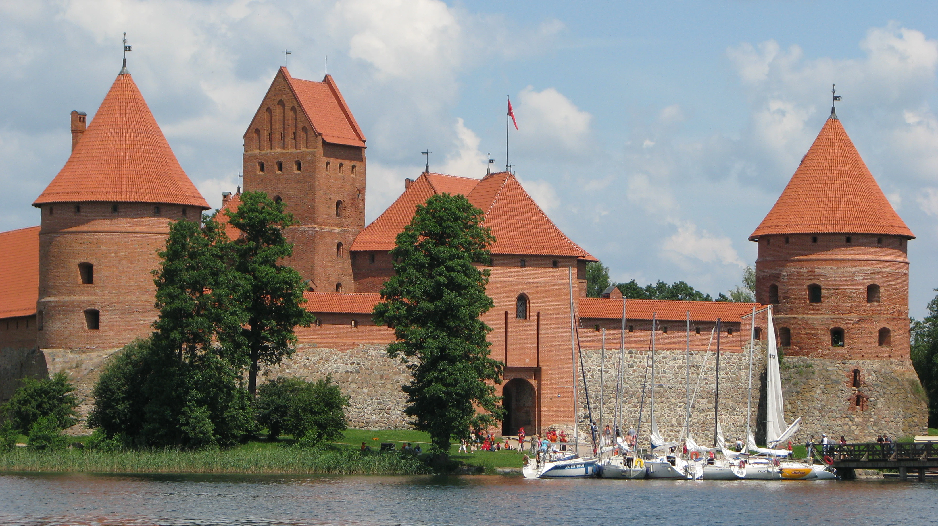
Red-roofed stone castle with multiple towers on a lake, surrounded by trees, with sailboats docked nearby
Front facade of Trakai Island Castle with sailboats on the water

Trakai National Historic Park ecosystems, habitats, and plant life

The natural environments within Trakai National Historic Park reflect the broader ecological characteristics of Lithuania's lake district in the southeastern part of the country. The park's forests are predominantly mixed woods containing species typical of the region, including various oaks, pines, spruces, and birches. The numerous lakes support aquatic ecosystems with fish populations that have historically provided local communities with food resources. Wetland areas around lake margins provide habitat for waterfowl and other bird species, while the interface between forest and water creates diverse ecological niches. The park's protected status helps maintain these natural habitats alongside the historical monuments, ensuring that visitors experience both cultural heritage and the natural landscape that shaped regional development.
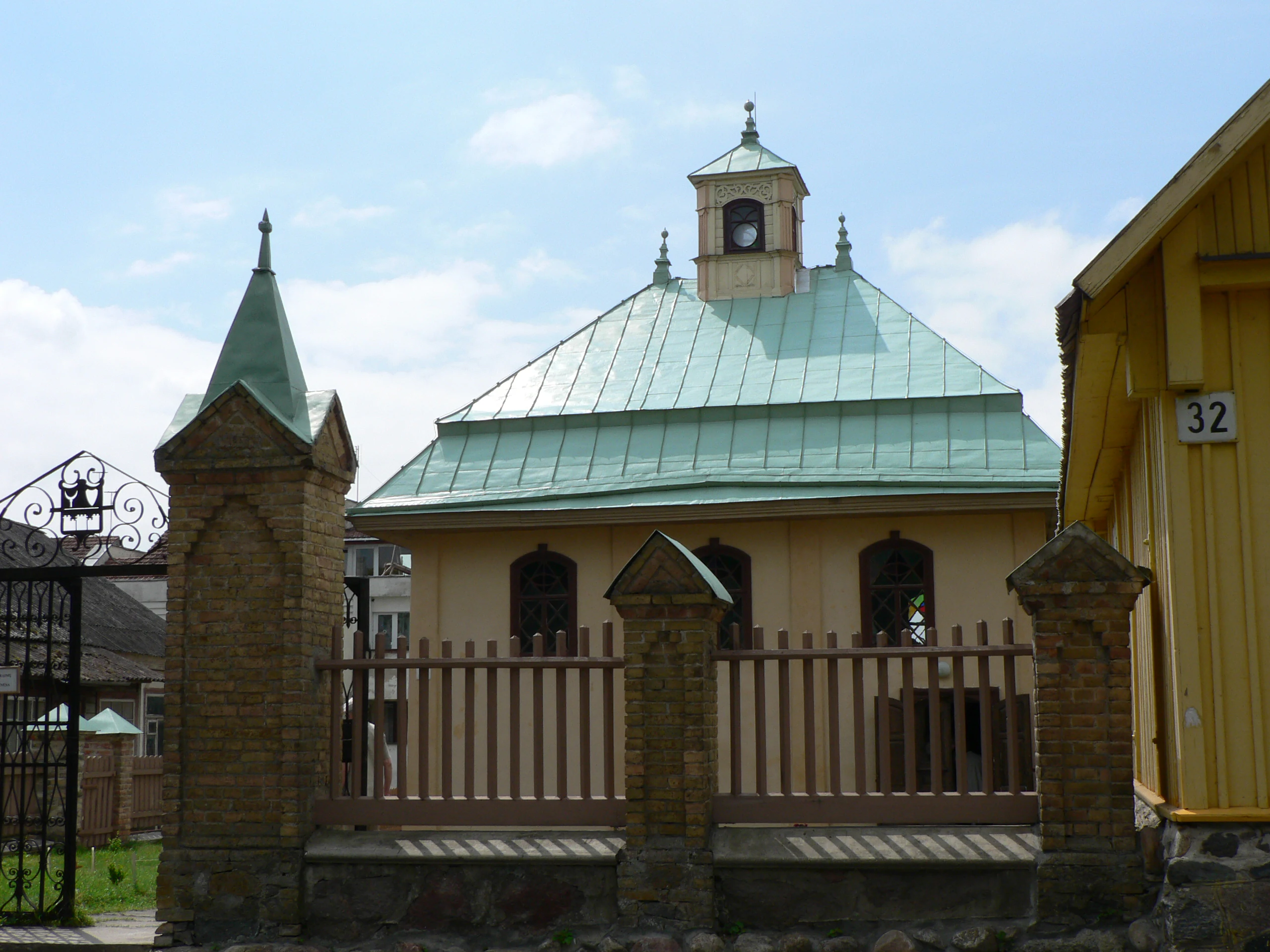
A beige building with a green copper roof, stone spires, and a wooden fence, located in Trakai National Historic Park
Karaite Kenesa building within Trakai National Historic Park

Trakai National Historic Park wildlife and species highlights

The wildlife communities within Trakai National Historic Park are characteristic of Lithuania's forest and lake environments. The forests shelter populations of roe deer, wild boar, and smaller mammals, while the lakes and wetlands support diverse waterfowl populations including ducks, swans, and grebes. The interconnected lake system provides corridors for wildlife movement and supports fish populations that are important both ecologically and for traditional local fishing. Birdlife is particularly notable in wetland areas, where seasonal migrations bring additional species during spring and autumn. The combination of forest cover, water bodies, and protected status creates habitats that support reasonable biodiversity within a landscape that has been shaped by long human presence.
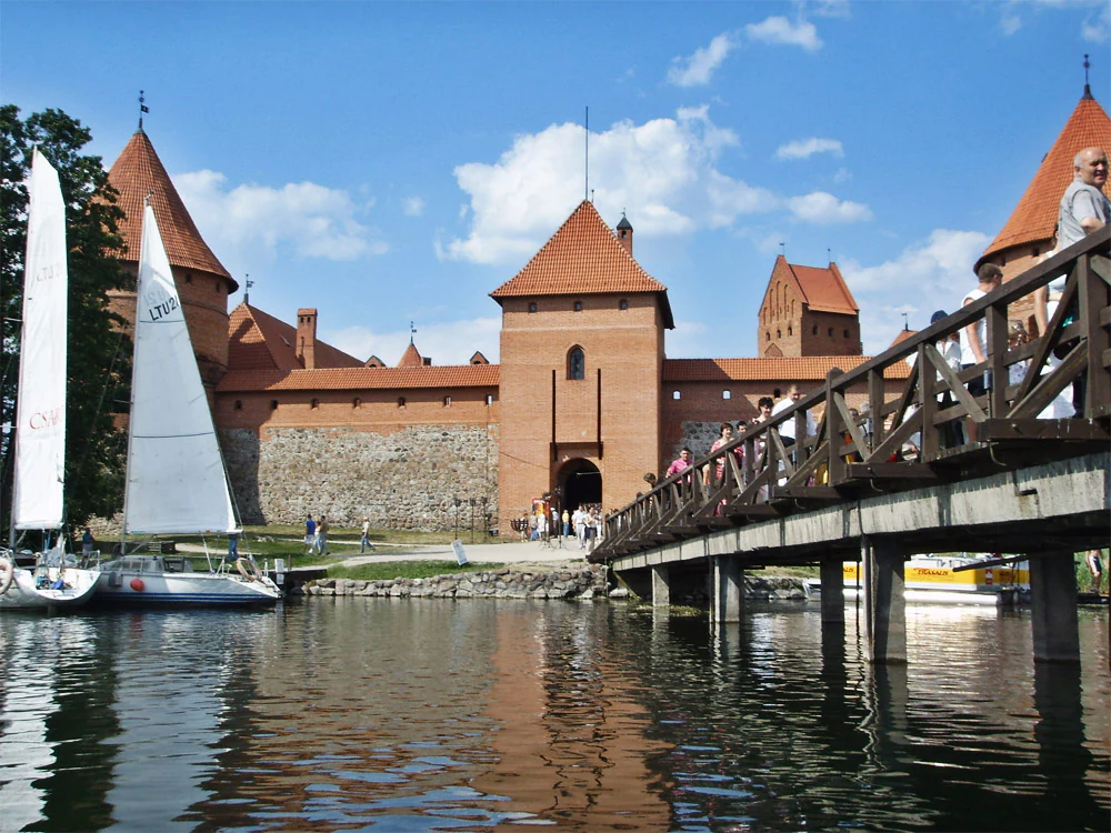
Trakai Castle with red-tiled roofs and stone walls, viewed across a body of water with a wooden bridge and sailboats
Trakai Castle with its bridge and boats on a sunny day

Trakai National Historic Park conservation status and protection priorities

Trakai National Historic Park serves dual conservation purposes, protecting both significant cultural heritage sites and the natural environments that surround them. The park's designation as a historical national park reflects Lithuania's commitment to preserving the physical remains of its medieval past, including not only prominent monuments like Trakai Castle but also smaller architectural features, archaeological sites, and the historical town layout. Simultaneously, the park's natural environments receive protection as part of the heritage landscape, recognizing that the historical significance of the area derives from the relationship between human achievement and the natural setting. This integrated approach to conservation distinguishes the park from purely archaeological preserves and reflects an understanding that cultural heritage exists within environmental contexts that themselves warrant protection.

Trakai National Historic Park cultural meaning and human context

Trakai holds a special place in Lithuanian national identity as the seat of power during the Grand Duchy's golden age under Vytautas the Great. The town and its castle symbolize the period when Lithuania was a major European power extending from the Baltic to the Black Sea. Beyond the grand ducal history, Trakai is notable for its religious diversity, having been home to both Christian and Karaite communities, with the Karaites arriving in Lithuania in the 14th century and establishing a distinctive community whose presence is still visible in the town. The surrounding lake district shaped the economic life of the region through fishing, transport, and water-powered industries, creating a cultural landscape where natural resources and human settlement evolved together over centuries.
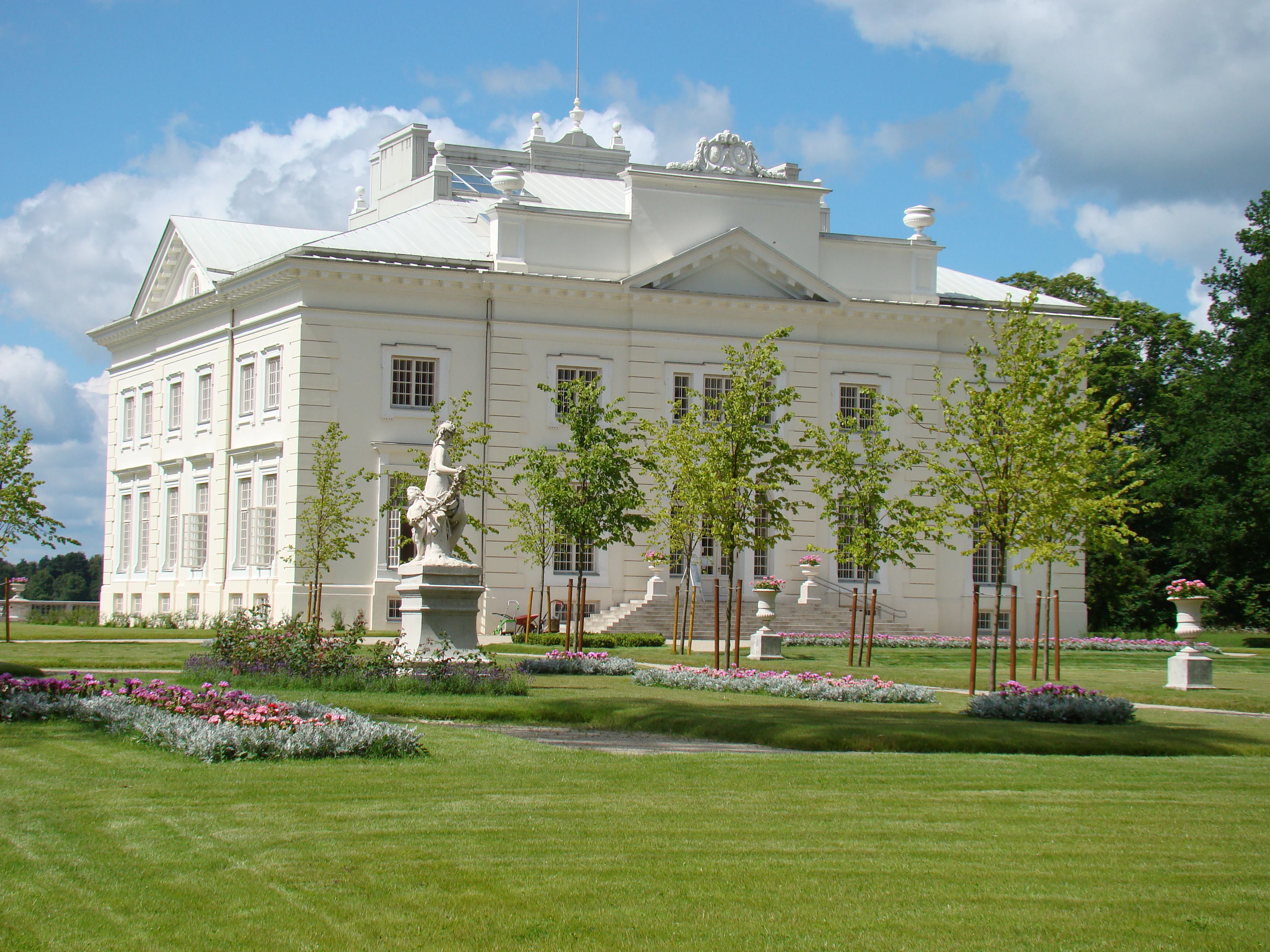
A large white manor house with a central statue in a landscaped garden, under a partly cloudy sky
Užutrakio Manor Palace in Trakai National Historic Park

Top sights and standout views in Trakai National Historic Park

The centerpiece of any visit to Trakai National Historic Park is Trakai Castle, the island fortress that served as a grand ducal seat and now houses a museum of medieval Lithuanian history. The historic town of Trakai, with its preserved architecture and car-free streets, provides a welcoming environment for exploring regional heritage. The network of lakes surrounding the town offers opportunities for boat excursions that provide unique perspectives on the castle and the surrounding landscape. The Karaite quarter in Trakai represents a distinctive cultural element unique to this part of Lithuania. The park's network of trails and cycling paths allows visitors to explore the natural environments beyond the town, experiencing the forests and smaller lakes that complete the historical landscape.
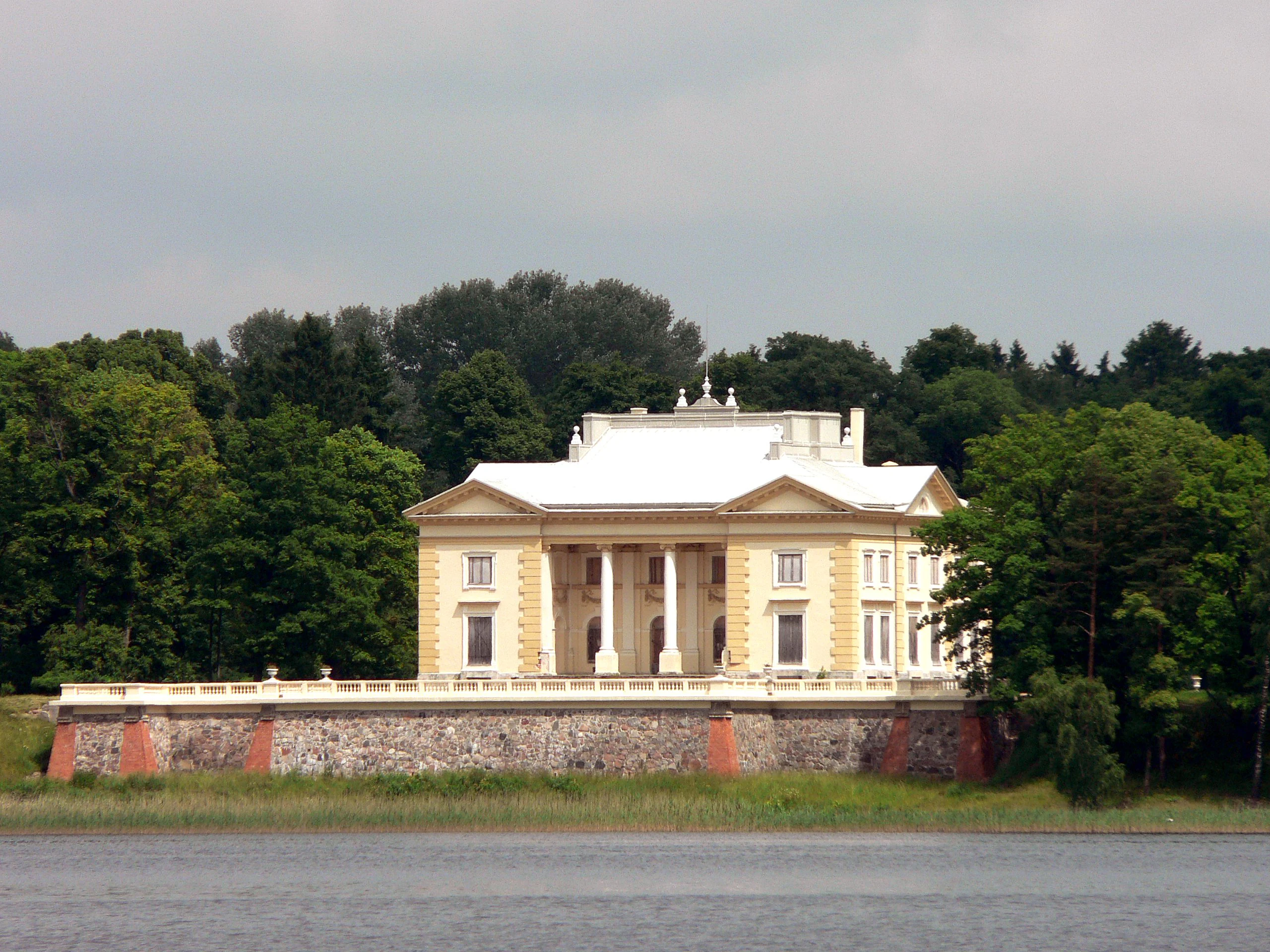
A large classical-style palace with columns on a stone foundation, situated by a body of water with green trees in the background
Tyszkiewicz palace on the shores of Lake Galvė in Trakai National Historic Park, Lithuania

Best time to visit Trakai National Historic Park

The optimal seasons for visiting Trakai National Historic Park are late spring through early autumn, when warm weather allows full enjoyment of the outdoor landscape and boat access to Trakai Castle. Summer months offer the most extensive opportunities for exploring the lakes and outdoor spaces, though they also bring larger crowds. Autumn provides colorful forest scenery and smaller visitor numbers, while the shoulder seasons of spring offer fresh vegetation and moderate conditions. Winter visits are possible but limited, as boat services to the castle island cease and many facilities operate on reduced schedules. The historical town of Trakai can be enjoyed year-round, though the full experience of the park's landscapes is most complete during the warmer months.
Monthly climate preview

Analyze long-term temperature ranges and precipitation trends across the annual cycle.

Average Temperature and Weather by Month in Trakai National Historic Park

Long-term representative data at 131 meters elevation show monthly mean temperatures ranging from -5.56 degrees Celsius up to a warm peak of 18.2 degrees Celsius. Comparing the complete twelve-month profile highlights the shifting precipitation patterns and extreme temperature variations recorded across the park terrain.
Annual mean6 °C
-6 °C18 °C
Jan-6°
Feb-5°
Mar
Apr
May12°
Jun16°
Jul18°
Aug17°
Sep12°
Oct
Nov
Dec-4°
Warmest month
July

18.2 °C

Coolest month
January

-5.6 °C

Wettest month
July

3 mm/day

Driest month
March

1.6 mm/day

Park location guide

Geography guide, regional context, and park location map for Trakai National Historic Park

Trakai National Historic Park park geography, regions, and map view in Lithuania

Understand where Trakai National Historic Park sits in Lithuania through a broader geographic reading of the surrounding landscape, nearby location context, and its mapped position within the national park landscape.

How Trakai National Historic Park fits into Lithuania

Lithuania is a unitary semi-presidential republic and one of three Baltic states in Northern Europe. It lies on the eastern coast of the Baltic Sea, with Vilnius as its capital and largest city. The country regained independence in 1990 after Soviet occupation and joined the European Union in 2004. Lithuania has a population of about 2.9 million and covers an area of 65,300 km².

Wider geography shaping Trakai National Historic Park in Lithuania

Lithuania is situated on the eastern shore of the Baltic Sea in Northern Europe. It borders Latvia to the north, Belarus to the east and south, Poland to the south, and Russia's Kaliningrad Oblast to the southwest. The country also has a maritime border with Sweden to the west. The terrain is largely flat with rolling hills, numerous lakes, and rivers. The Nemunas River is the longest river in the country.

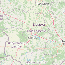
Map view of Trakai National Historic Park

Use this park location map to pinpoint Trakai National Historic Park in Lithuania, understand its exact geographic position, and read its mapped placement within the surrounding landscape more clearly.

Pigeon | © OpenStreetMap contributors

Examine the diverse lake district, forested hills, and historic monuments that define this protected landscape.

Trakai National Historic Park Photos: Explore Historic Landscapes and Protected Area Scenery

Viewing imagery of Trakai National Historic Park offers essential visual context for its unique blend of medieval heritage and natural lake district environment. These photos reveal the iconic Trakai Castle on Lake Galvė, the surrounding forests, wetlands, and the overall scenic character that defines this significant Lithuanian protected area.

Circular emblem with 'TRAKŲ' text at top, 'ISTORINIS NACIONALINIS PARKAS' text around edges, yellow castle illustration on red background, and blue-white wavy lines representing water

Trakai Island Castle with red roofs on a lake, surrounded by trees, with sailboats and a small boat on the water under a partly cloudy sky

Red-roofed stone castle with multiple towers on a lake, surrounded by trees, with sailboats docked nearby

A beige building with a green copper roof, stone spires, and a wooden fence, located in Trakai National Historic Park

Trakai Castle with red-tiled roofs and stone walls, viewed across a body of water with a wooden bridge and sailboats

Historic stone wall and red-tiled tower in Trakai National Historic Park.

A large white manor house with a central statue in a landscaped garden, under a partly cloudy sky

A large classical-style palace with columns on a stone foundation, situated by a body of water with green trees in the background

Park atlas

Explore the Surrounding Lake Districts and Historic Protected Landscapes for Atlas Comparison

Discover More Protected Areas and National Parks Near Trakai National Historic Park

Continue your exploration beyond Trakai National Historic Park by browsing nearby protected areas, comparing diverse cultural landscapes, and tracing regional conservation efforts across Lithuania and surrounding Eastern European geography. Gain deeper insights into how historical sites, glacial lakes, and dense forests shape the unique protected-area network around Trakai.
Nature reserveTrakai District Municipality
About 7.1 km away#1 closest

Southeast

Mergiškių gamtinis rezervatas Protected Nature Reserve in Trakai District Municipality

Strictly protected hornbeam woodland and hilly glacial terrain

Mergiškių gamtinis rezervatas is a protected area in Lithuania dedicated to conserving mature hornbeam-dominated hill forest. Located within the Trakai District Municipality, the reserve provides a critical habitat for threatened species and maintains the natural integrity of hilly glacial landscapes typical of the Aukštadvaris region.

Area
1.57 km²
Established
1996
IUCN
Ia
Relief
Upland
Watercolor illustration of a wooden boardwalk path winding through a flat landscape with scattered trees, soft grasses, and muted natural colors.
Nature reserveKauno rajono savivaldybė
About 32 km away#2 closest

Northwest

Dubravos rezervatinė apyrubė: Protected Nature Reserve and Baltic Forest Geography

Central Lithuania protected landscape and wetland mapping

This nature reserve in the Kaunas district protects a rare combination of mature pine forest and open raised bog habitats. By preserving long term undisturbed ecological processes, it provides a stable reference point for forest dynamics in the region. Explore the structural complexity of these coniferous stands and the distinct wetland characteristics of this protected Baltic landscape.

Area
1.2 km²
Established
1994
IUCN
Ia
Relief
Lowland
Watercolor illustration showing a landscape with forests, a river, and distant hills
National parkLithuania
About 46 km away#3 closest

South

Dzūkija National Park: Explore Lithuania's Largest Protected Forest and Inland Dune Landscapes

Mapped protected area geography and natural terrain of the Dainava region.

Delve into the protected landscape of Dzūkija National Park, Lithuania's expansive national park renowned for its vast primeval pine forests and extraordinary inland dune formations. This page provides a detailed atlas-style view of the park's mapped boundaries, diverse terrain, and significant natural features, offering insight into its protected territory and regional geographic importance. Examine the unique wetland systems and forest ecosystems that make this a crucial area for protected land discovery.

Area
584.53 km²
Established
1991
IUCN
II
Visitors
30K annual
Biosphere reserveKauno rajonas
About 54 km away#4 closest

Northwest

Babtų-Varluvos miškų biosferos poligonas: Protected Forest Landscapes and Geographic Mapping

Essential woodland corridors in Kaunas district, Lithuania

Babtų-Varluvos miškų biosferos poligonas functions as a significant biosphere reserve focused on mature lowland forest conservation. This protected area offers a look at continuous woodland structures, research-focused biodiversity monitoring, and the spatial significance of forest corridors within central Lithuanian geography.

Area
44.19 km²
Established
2004
IUCN
VI
Relief
Lowland
A horizontal watercolor painting showing a soft, impressionistic landscape with trees on both sides and a gentle rolling hill in the background.
Nature reserveVarėna District Municipality
About 61 km away#5 closest

South

Povilnio Rezervatas: Protected Nature Reserve and Glacial Valley Geography in Varėna District

Glacial landscape study within the Dainava Forest massif

Located in the Varėna District, Povilnio Rezervatas is a protected nature reserve defined by its striking glacial spillway valley and diverse forest communities. This area encompasses a complex mosaic of lichen-rich pine heaths, spruce forests, and alder mires, making it a critical site for botanical conservation and regional geomorphology studies.

Area
1.832 km²
Established
1997
IUCN
Ia
Relief
Lowland
Watercolor illustration of a serene river landscape with green trees, grassy banks, and rolling hills in the background.
Nature reserveVarėna District Municipality
About 62 km away#6 closest

South

Skroblaus rezervatas: Protected Nature Reserve and Baltic Upland Geographic Reference Site

Natural hydrological basin and inland dune landscapes in Varėna District Municipality

Skroblaus rezervatas functions as a strict nature reserve protecting the natural hydrological regime of the Baltic uplands. Located in the Varėna District Municipality, the terrain features deep stream valleys, thermokarst depressions, and inland dune massifs. This mapped area offers a deep look into the geomorphology and forest ecology of southern Lithuania, providing essential context for understanding undisturbed upland water systems.

Area
8.107 km²
Established
1983
IUCN
Ia
Relief
Upland
Biosphere reserveUkmergė District Municipality
About 67 km away#7 closest

North

Viliukų, Karpių miškai Biosphere Reserve: Regional Protected Area Geography and Maps

Broadleaved forests and wetland ecosystems in central Lithuania

Gain insights into the protected landscape of Viliukų, Karpių miškai in the Ukmergė District. This biosphere reserve provides a detailed view of lowland forest ecosystems, characterized by spruce and birch dominance within an undulating terrain that sustains rare insect and plant communities.

Area
7.772 km²
Established
2012
Relief
Lowland
Scope
Terrestrial
A watercolor painting showing a wide, panoramic view of a marshy wetland with patches of green vegetation, small trees, and low hills in the distance.
Nature reserveVarėna District Municipality
About 72 km away#8 closest

South

Čepkeliai Nature Reserve: Mapped Geography and Protected Wetland Landscape in Lithuania

A wild expanse of raised bogs and inland dunes.

Čepkeliai Nature Reserve features an exceptionally large and undisturbed raised bog complex situated in southern Lithuania. This protected territory within the Varėna District Municipality spans varied terrain, including stabilized sandy dunes, forested islands, and the Katra River valley. Its complex ecological structure preserves rare bird populations and deep peat deposits that reflect centuries of post-glacial history.

Area
112.12 km²
Established
1975
IUCN
Ia
Relief
Lowland

Common questions about visiting, size, designation, and location context for Trakai National Historic Park

Trakai National Historic Park FAQs for park facts, access, geography, and protected area context

Find quick answers about Trakai National Historic Park, including protected-area facts, park geography, trail and visitor context, and how the park fits into its surrounding country and regional landscape.
MoriAtlas Explorer

Continue Your Protected Areas Search Across the Global Atlas

Deepen your exploration by continuing the structured search for national parks and protected areas worldwide. Utilize the comprehensive filtering capabilities to compare different conservation landscapes and refine your understanding of global park geography. Discover more about the distribution and characteristics of protected natural areas.

Global natural geography