Mori Atlas logo
National parkTsavo East National Park

Discover the mapped boundaries and regional geography of this significant Kenyan national park.

Tsavo East National Park: Kenya's Vast Protected Landscape and Geographic Atlas Entry

Tsavo East National Park stands as a prominent protected area within the diverse geography of Kenya. As a core entity in the national park atlas, it offers crucial insights into mapped landscapes, protected boundaries, and the regional context of East Africa. Exploring this park reveals distinct aspects of Kenya's natural terrain and its role in conservation, providing a focal point for geographic understanding and atlas-based discovery of its protected land.

SavannaElephant HabitatBig FiveKenyaSemi-Arid WildernessLion Conservation

Tsavo East National Park

National park

Park overview

Structured park overview, official facts, and landscape profile for Tsavo East National Park

Tsavo East National Park park facts, protected area profile, and essential visitor context
Review the core facts for Tsavo East National Park, including designation, size, terrain, visitor scale, habitats, and operating context in one park-focused overview.

About Tsavo East National Park

Tsavo East National Park stands as one of Kenya's premier wilderness areas and a cornerstone of the nation's conservation portfolio. Located in the semi-arid southeastern region of the country, the park covers an expansive 13,747 square kilometers, making it one of the largest protected areas in Kenya. The landscape is predominantly flat savanna, characterized by dry plains that support a remarkable diversity of wildlife despite the challenging climate. The park's hydrology is defined by the Galana River, which flows through the reserve from west to east, and the Athi-Galana-Sabaki River system, formed by the confluence of the Athi and Tsavo rivers within the park boundaries. The Yatta Plateau, running along the western boundary, is a striking geological feature representing the world's longest lava flow, stretching approximately 290 kilometers and formed from volcanic activity originating from Ol Donyo Sabuk Mountain. The park's vegetation consists primarily of semi-arid grasslands and savanna, with scattered acacia trees and bushland providing essential browse for the park's substantial herbivore populations. Tsavo East operates as part of a larger conservation complex, connected to Tsavo West National Park to form a contiguous protected area of roughly 22,000 square kilometers that supports one of Kenya's most significant wildlife ecosystems.

Quick facts and research context for Tsavo East National Park

Tsavo East National Park covers 13,747 square kilometers in southeastern Kenya, making it one of the largest national parks in the country. Established in April 1948, it occupies a semi-arid savanna landscape in Taita-Taveta County. The park is characterized by flat plains, the Galana River, the Yatta Plateau (the world's longest lava flow at 290 kilometers), and notable geological features including Mudanda Rock and Lugard Falls. Together with Tsavo West, the protected area spans approximately 22,000 square kilometers. The park is managed by the Kenya Wildlife Service and is home to significant populations of lions, elephants, giraffes, zebras, and more than 500 bird species.

Park context

Deeper park guide and search-rich context for Tsavo East National Park

Tsavo East National Park history, landscape, wildlife, and travel context
Explore Tsavo East National Park through its history, landscape character, ecosystems, wildlife, conservation priorities, cultural context, and seasonal travel timing in a structured park guide built for atlas discovery and search intent.

Why Tsavo East National Park stands out

Tsavo East is best known for its legendary wildlife, particularly the Tsavo lions, a distinctive population whose adult males famously lack the elaborate manes typical of their species. The park is also celebrated for its elephant populations, including famous tuskers like Dida, known as the Queen of Tsavo, and Satao, whose deaths from natural causes and poaching respectively drew international attention. The Yatta Plateau, the world's longest lava flow stretching 290 kilometers along the park's western boundary, represents a remarkable geological feature. The park's vast savanna landscapes, crossed by the Galana River and dotted with inselbergs like Mudanda Rock, provide critical habitat for diverse wildlife including giraffes, zebras, buffalo, and abundant birdlife.

Tsavo East National Park history and protected-area timeline

The human history of Tsavo East spans thousands of years, with archaeological evidence revealing Late Stone Age occupations from approximately 6,000 to 1,300 years ago, particularly concentrated along the Galana River. These ancient inhabitants hunted wild animals, practiced fishing, and kept domesticated livestock. Evidence of Swahili trade networks reaching Tsavo dates to around 700 CE, with archaeological sites yielding cowry shells and beads that traveled via extended kin-networks from the Swahili Coast. During the 19th century, British and German explorers documented the Orma pastoralists and Watha hunter-gatherers who inhabited the region, referring to the area as the nyika or bush. The construction of the Kenya-Uganda railway through Tsavo in 1898 marked a dramatic turning point, as the infamous Tsavo Man-Eaters, a pair of lions that killed over 130 workers, terrorized construction crews before being shot by John Henry Patterson. In 1948, Tsavo was gazetted as a national park, resulting in the forced removal of the Orma pastoralists and Watha hunter-gatherers from their ancestral lands to settlements including Voi, Mtito Andei, and the Taita Hills. Following Kenyan independence in 1963, hunting was banned within the park and management transferred to what became the Kenya Wildlife Service, establishing the modern conservation framework that continues today.

Tsavo East National Park landscape and geographic character

The landscape of Tsavo East National Park is defined by its vast, flat semi-arid plains that stretch to the horizon in every direction, creating one of Kenya's most distinctive wilderness vistas. The terrain is predominantly flat with minimal elevation change, broken only by prominent geological features that rise dramatically from the surrounding savanna. The Yatta Plateau, the world's longest lava flow at 290 kilometers, runs along the western boundary of the park above the Athi-Galana-Sabaki River, its dark volcanic rock creating a striking contrast against the lighter savanna grasses. Mudanda Rock is a 1,600-meter inselberg of stratified rock that serves as a natural water catchment, forming a dam in the valley below and providing an exceptional vantage point for wildlife viewing during the dry season when elephants and other animals congregate at its base. The Galana River flows west to east through the park, providing a vital water source that sustains wildlife throughout the year. Lugard Falls consists of a series of white-water rapids on the Athi-Galana-Sabaki River, named after Frederick Lugard. Aruba Dam, constructed in 1952 across the Voi River, creates a reservoir that attracts numerous water birds and wildlife, particularly during the dry months.

Tsavo East National Park ecosystems, habitats, and plant life

Tsavo East National Park supports a complex semi-arid savanna ecosystem that demonstrates remarkable resilience in the face of challenging climatic conditions. The park's vegetation is characterized by grasslands interspersed with acacia woodlands and bushland, forming a habitat matrix that supports extraordinary wildlife densities despite the limited rainfall. The semi-arid conditions have shaped the evolution of specialized plant and animal species adapted to drought tolerance and water-efficient survival strategies. The riparian areas along the Galana River and other water sources support more luxuriant vegetation, creating linear oases that provide critical refuge for wildlife during dry periods. The park's extensive savanna provides optimal conditions for large herds of grazers and browsers, with the open terrain facilitating predator-prey interactions that define the ecosystem's dynamics. The semi-arid environment, while challenging, supports a biodiversity-rich community of organisms uniquely adapted to seasonal moisture variations and temperature extremes.

Tsavo East National Park wildlife and species highlights

Tsavo East National Park is considered one of the world's biodiversity strongholds, providing undeveloped habitat for vast numbers of animals across numerous species. The Tsavo lions represent a distinctive population, with adult males characteristically lacking the luxuriant manes found in other lion populations, and the Amboseli-Tsavo ecosystem supports approximately 675 lions. The park is renowned for its elephant populations, including famous tuskers like Dida, the Queen of Tsavo, who died in 2022 at an estimated 60-65 years of age after leading elephant herds for multiple generations, and Satao, a legendary tusker killed by poachers in 2014 after living in the park for over four decades. The mammal fauna is exceptionally diverse, with over 60 species recorded including African bush elephants, giraffes, plains zebra, Grevy's zebra, African buffalo, common eland, impala, waterbuck, black rhinoceros, African wild dogs, cheetahs, leopards, and numerous smaller mammals. The bird community exceeds 500 species, including ostriches, kestrels, buzzards, starlings, weaver birds, kingfishers, hornbills, secretary birds, and herons. The park's wildlife faces ongoing challenges from drought, human-wildlife conflict, and poaching pressures.

Tsavo East National Park conservation status and protection priorities

Tsavo East National Park represents a critical conservation asset within Kenya's protected area network, safeguarding one of the country's most significant savanna ecosystems and its associated wildlife populations. The park's establishment in 1948 marked a pioneering effort to preserve Kenya's natural heritage, and today it forms part of a larger conservation complex with Tsavo West that spans approximately 22,000 square kilometers. The Kenya Wildlife Service manages the park, implementing conservation programs that address the multiple threats facing the ecosystem, including poaching, human-wildlife conflict, and the impacts of climate change and drought. Conservation challenges are substantial, with elephants raiding farms causing conflict with surrounding communities, and poaching for ivory and bushmeat continuing to threaten key species. The loss of iconic tuskers like Satao and Satao II to poaching highlighted the ongoing vulnerability of the park's wildlife. Drought represents an increasing threat, with the severe drought of 2022 causing significant wildlife mortality across the Tsavo ecosystem. Conservation partnerships with organizations like the Tsavo Trust and Save the Elephants support monitoring and protection efforts.

Tsavo East National Park cultural meaning and human context

The cultural landscape of Tsavo East encompasses thousands of years of human habitation and interaction with the environment, though the modern protected area was established through the displacement of its indigenous inhabitants. The park was historically the homeland of the Orma pastoralists and Watha hunter-gatherers, whose relationship with the land shaped the region's cultural identity for generations. Archaeological evidence reveals Late Stone Age settlements along the Galana River dating back 6,000 years, with inhabitants who hunted, fished, and kept livestock. Swahili traders from the coast engaged with interior communities from around 700 CE, exchanging goods including ivory, catskins, and potentially slaves through extended kinship networks rather than direct colonization. The 1898 construction of the railway brought dramatic change, and the park's gazettment in 1948 resulted in the forced relocation of the Orma and Watha to Voi, Mtito Andei, and the Taita Hills. Today, surrounding communities including Taita Taveta continue to maintain cultural connections to the region, though the park itself is managed as a strictly protected wilderness area.

Top sights and standout views in Tsavo East National Park

Tsavo East National Park offers exceptional wildlife viewing across its vast savanna landscapes, with the opportunity to observe large elephant herds, prides of the distinctive maneless Tsavo lions, giraffes, zebras, and abundant birdlife. The Yatta Plateau provides a unique geological experience as the world's longest lava flow, while Mudanda Rock offers one of the park's most spectacular wildlife viewing vantage points where hundreds of elephants gather during the dry season. The Galana River and Aruba Dam provide reliable wildlife viewing opportunities, particularly for water birds and animals seeking refreshment. The park's historical significance, from Late Stone Age settlements through the dramatic railway construction era, adds depth to the visitor experience. The combination of vast wilderness, iconic wildlife, geological wonders, and historical layers makes Tsavo East one of Kenya's most compelling protected areas.

Best time to visit Tsavo East National Park

The optimal time to visit Tsavo East National Park is during the dry seasons, typically from June to October and from January to March, when wildlife congregates around remaining water sources and vegetation is less dense, making animals easier to spot. The dry months offer the best wildlife viewing opportunities as animals concentrate along the Galana River, Aruba Dam, and other water sources. The wet seasons, from November to December and April to May, bring rainfall that temporarily disperses wildlife across the park and can make some roads difficult to navigate. However, the wet seasons transform the landscape with fresh green vegetation and are ideal for birdwatching when migratory species arrive. Visitors should be prepared for the semi-arid conditions regardless of season, with hot temperatures throughout the year and the possibility of drought conditions affecting water availability. The park's accessibility and infrastructure are generally better during the peak dry season when most visitors choose to travel.

Park location guide

Geography guide, regional context, and park location map for Tsavo East National Park

Tsavo East National Park park geography, regions, and map view in Kenya
Understand where Tsavo East National Park sits in Kenya through a broader geographic reading of the surrounding landscape, nearby location context, and its mapped position within the national park landscape.

How Tsavo East National Park fits into Kenya

Kenya is a presidential republic in East Africa and the seventh-most populous country on the continent. Its capital is Nairobi, and it borders five countries and the Indian Ocean. The country features significant geographic diversity including Mount Kenya, the Rift Valley, and coastal regions.

Wider geography shaping Tsavo East National Park in Kenya

Kenya is located in East Africa, bordering South Sudan to the northwest, Ethiopia to the north, Somalia to the east, Tanzania to the southwest, and Uganda and Lake Victoria to the west. The southeastern border meets the Indian Ocean. The geography includes the Rift Valley highlands with Mount Kenya, coastal plains, and northern arid regions.

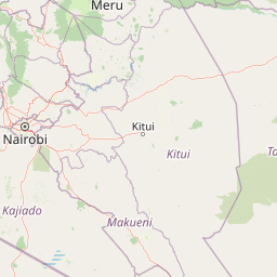
Map view of Tsavo East National Park

Use this park location map to pinpoint Tsavo East National Park in Kenya, understand its exact geographic position, and read its mapped placement within the surrounding landscape more clearly.

Pigeon | © OpenStreetMap contributors

Location context for Tsavo East National Park

Taita-Taveta County
Park atlas

Explore Kenya's Connected Protected Landscapes and Regional Park Geography

Discover Other National Parks and Protected Areas Near Tsavo East National Park
Continue your exploration from Tsavo East National Park by browsing other national parks and protected areas across Kenya's vast semi-arid savannas and connected conservation landscapes. Compare different park geographies, discover adjacent wildlife habitats, and trace the regional spread of protected zones to deepen your understanding of East African wilderness.
National parkTaita-Taveta County

Tsavo West National Park: Kenya's Protected National Park and Regional Geography

Explore mapped boundaries and natural landscapes in Taita-Taveta County.

Tsavo West National Park offers a focused exploration of protected landscape and regional geography within Kenya. Discover the mapped extent of this national park, understanding its role as a conservation area in Taita-Taveta County. This entry provides key geographic context and atlas-style information, highlighting the natural terrain and protected boundaries for detailed discovery.

Area
9,065 km²
Established
1948
IUCN
II
Relief
Mixed relief
National parkCoast Province

Arabuko Sokoke National Park: National Park Atlas and Geographic Identity in Coast Province

Mapped protected area within Kenya's coastal region.

Arabuko Sokoke National Park is identified as a protected national park situated within the historical Coast Province of Kenya. This entry offers a focused examination of its protected landscape and geographic significance, contributing to a structured atlas of protected areas. Users can explore the park's mapped boundaries and its positioning within the regional geography, providing essential context for understanding this natural landscape.

Area
6 km²
Established
1990
IUCN
II
Relief
Lowland
Marine protected areaKenya

Watamu Marine National Park: Coastal Protected Marine Landscape in Kenya

Explore mapped boundaries and regional geography.

Watamu Marine National Park represents a crucial marine protected area situated on Kenya's coastline, contributing significantly to the country's conservation landscape. This designation underscores its role in preserving coastal and underwater geography, making it a key entity for atlas exploration of protected marine environments. Understanding its specific geographic scope and mapped protected boundaries is essential for comprehending Kenya's broader environmental atlas.

Established
1968
Relief
Lowland
Climate
Tropical
Access
Moderate access
National parkKilimanjaro Region

Kilimanjaro National Park: Protected Landscape Geography and Atlas Exploration

Explore its mapped boundaries and regional context.

Delve into Kilimanjaro National Park, a protected national park situated in the Kilimanjaro Region. This detail page offers an atlas-driven view of the park's geographic scope, focusing on its mapped boundaries and the surrounding natural landscape. Understand the unique terrain and regional context that make this protected area a significant feature within Tanzania's geography.

Area
1,688 km²
Established
1973
IUCN
II
Visitors
52K annual
Watercolor painting showing a landscape with mountains in the background, green hills in the midground, and water or wetland in the foreground
National parkKenya

Malindi Marine National Park: Kenya's National Park Atlas of Coastal Protected Lands

Explore mapped marine geography and protected landscape context.

Malindi Marine National Park is a protected national park situated along Kenya's coast, contributing to the nation's atlas of conservation landscapes. This entry details the park's specific geographic identity, its mapped boundaries, and its role as a protected marine environment. Engage with its regional context and understand how its protected status shapes its unique landscape for a deeper geographic appreciation.

Relief
Lowland
Climate
Tropical
Access
Access unknown
Scope
Marine
National parkKenya

Amboseli National Park: Kenya National Park Protected Landscape Atlas

Mapped geographic context and protected area boundaries.

Amboseli National Park is a protected national park in Kenya, offering a distinct geographic entity for exploration. This atlas-focused view details the park's mapped boundaries and regional landscape context. Understand its role as a national park and a significant protected area within the broader geography of Kenya for structured discovery.

Area
392 km²
Established
1974
IUCN
II
Visitors
120K annual
National parkTanzania

Mkomazi National Park: Tanzania's Vast Protected Savanna Landscape and Wildlife Geography

Explore its mapped terrain and conservation significance within East Africa.

Mkomazi National Park is a critical protected landscape in Tanzania, spanning over 3,200 square kilometers of classic East African semi-arid savanna woodland. This national park offers a unique atlas-style view into conservation success, particularly for its black rhinoceros sanctuary and African wild dog programs. Its landscape is characterized by rolling terrain and Acacia-Commiphora vegetation, forming a vital transboundary conservation area with Kenya that supports significant wildlife migration corridors and provides a distinct geographic context within the broader regional atlas.

Area
3,234 km²
Established
2006
IUCN
II
Visitors
1.6K annual
National parkArusha Region

Arusha National Park: A Protected Landscape in Tanzania's Arusha Region

Explore its mapped boundaries and regional geography.

Arusha National Park represents a significant protected landscape within the Arusha Region of Tanzania, offering specific geographic details for atlas-based exploration. This national park's identity is tied to its mapped natural terrain and its position within the broader regional context. Users can delve into the park's protected status and geographic features, making it a valuable entity for understanding the landscape of northern Tanzania.

Area
137 km²
Established
1960
IUCN
II
Visitors
66.8K annual

Common questions about visiting, size, designation, and location context for Tsavo East National Park

Tsavo East National Park FAQs for park facts, access, geography, and protected area context
Find quick answers about Tsavo East National Park, including protected-area facts, park geography, trail and visitor context, and how the park fits into its surrounding country and regional landscape.
MoriAtlas Explorer

Continue Your Protected Areas Search Across the Global Atlas

Deepen your exploration by continuing the structured search for national parks and protected areas worldwide. Utilize the comprehensive filtering capabilities to compare different conservation landscapes and refine your understanding of global park geography. Discover more about the distribution and characteristics of protected natural areas.

Global natural geography