

Mori Atlas logo
Nature reserveTsolwana Nature Reserve

Mapping the transitional geography of grassland plains, mountain ridges, and thornveld

Tsolwana Nature Reserve: A Protected Landscape at the Edge of the Great Karoo and Winterberg

Spanning 8,500 hectares in the Eastern Cape of South Africa, Tsolwana Nature Reserve represents a critical transitional zone between the rugged Winterberg Mountain range and the semi-arid expanses of the Great Karoo. The terrain is characterized by a mosaic of grassy plains, acacia thornveld, and steep mountain slopes, with the Black Kei River defining sections of its western boundary. Visitors can examine the distinct geological profile dominated by the cone-shaped Spitskop hill as they trace the ecological boundaries of this significant protected area.

nature reserveKaroograsslandthornveldWinterberg MountainsEastern Cape

Tsolwana Nature Reserve

Nature reserve

Park overview

Structured park overview, official facts, and landscape profile for Tsolwana Nature Reserve

Tsolwana Nature Reserve park facts, protected area profile, and essential visitor context

Review the core facts for Tsolwana Nature Reserve, including designation, size, terrain, visitor scale, habitats, and operating context in one park-focused overview.

About Tsolwana Nature Reserve

Tsolwana Nature Reserve occupies a distinctive ecological position in South Africa's Eastern Cape, sitting at the meeting point between the Winterberg Mountains and the Great Karoo. The reserve spans roughly 8,500 hectares of varied terrain that rises from lowland elevations around 1,350 meters to mountainous heights near 1,800 meters. This altitudinal range, combined with the reserve's location at the edge of the Karoo, creates a landscape where grassy plains, acacia thornveld, montane slopes, and valley systems coexist.

The reserve is bounded to the west by the upper Black Kei River, a defining geographic feature that shapes both the ecology and the visual character of the area. The name "Tsolwana" itself reflects local cultural heritage, drawn from the Xhosa word for "spike" in reference to Spitskop, the cone-shaped hill that has become a recognizable feature of the reserve's skyline. The setting combines the open, expansive feel of Karoo landscapes with the more rugged influence of the Winterberg range.

Ecologically, Tsolwana sits within a transitional zone where summer rainfall, variable weather, and drought history have shaped a resilient but sensitive environment. The land is susceptible to soil erosion and degradation, a condition that historically drove conservation action in the region. The reserve's current protected status reflects more than four decades of land management aimed at restoring ecological balance and supporting indigenous wildlife populations.

Beyond its conservation role, Tsolwana holds community significance by providing employment and economic links to nearby villages such as Tentergate, Thornhill, Waverley, and Khwezi. This connection between protected-area management and local livelihoods adds a social dimension to the reserve's identity in rural Eastern Cape.

Quick facts and research context for Tsolwana Nature Reserve

Tsolwana Nature Reserve covers approximately 8,500 hectares at the margin of Eastern Cape Province's Winterberg Mountains, with elevations ranging from around 1,350 meters in lowland areas to about 1,800 meters in mountainous sections. It lies within a transitional zone where grasslands meet the Karoo, and its western boundary follows the upper course of the Black Kei River. The reserve was proclaimed in 1979 and has been under the management of the Eastern Cape Parks Board since 2005.

The local climate is semi-arid and variable, marked by summer rainfall peaks between January and March, winter snowfall, hot summer days reaching around 38 degrees Celsius, and frost in winter. Vegetation is dominated by grassy plains and acacia thornveld, supporting a mix of plains antelope, larger mammals such as white rhino and giraffe, and birdlife including the blue crane, Cape vulture, and ostrich.

Protection and recognition

Explore documented protection status and official recognition history for Tsolwana Nature Reserve.

Tsolwana Nature Reserve Protection Status and International Recognition Data

Tsolwana Nature Reserve brings together documented protection status, designation history, and management scope within a structured regional framework. Each protected area profile provides verified conservation records and international recognition details for geographic analysis.

Protection details

Transboundary protection
No
Park context

Deeper park guide and search-rich context for Tsolwana Nature Reserve

Tsolwana Nature Reserve history, landscape, wildlife, and travel context

Explore Tsolwana Nature Reserve through its history, landscape character, ecosystems, wildlife, conservation priorities, cultural context, and seasonal travel timing in a structured park guide built for atlas discovery and search intent.

Why Tsolwana Nature Reserve stands out

Tsolwana Nature Reserve is best known as a Karoo-edge conservation area that emerged from state-led efforts to reduce livestock pressure and combat soil erosion during the severe droughts of the late 1960s. Its landscape combines Winterberg mountain slopes with open Karoo grasslands and acacia thornveld, creating a transitional habitat zone between highland Eastern Cape and semi-arid interior. The reserve is also recognized for its wildlife profile that blends Karoo plains antelope such as springbok, blesbok, and gemsbok with mountain-edge species like eland, kudu, and Cape mountain zebra, alongside larger mammals including white rhino and giraffe. Birdwatchers associate Tsolwana with the blue crane, South Africa's national bird, as well as Cape vultures and ostriches that move across the open terrain.
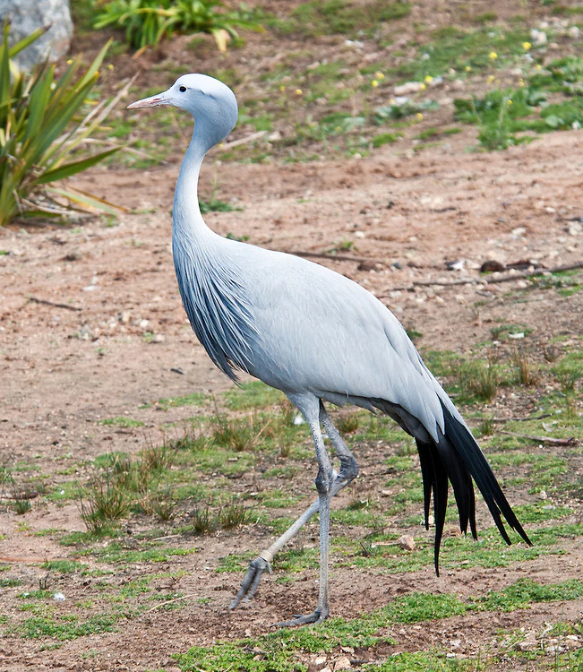
Blue Crane
A blue crane in Tsolwana Nature Reserve.

Tsolwana Nature Reserve history and protected-area timeline

Tsolwana Nature Reserve was proclaimed in 1979 after decades of landscape change driven by South Africa's severe drought of the late 1960s. During that drought, the government introduced state-subsidised stock reduction schemes aimed at lowering livestock pressure on fragile land, with the broader goal of protecting soil against erosion. Over time, the reduction in grazing animals allowed indigenous wildlife populations to recover across the region.

The visible recovery of wildlife and vegetation eventually led to the formal recognition of the area as a conservation zone. For many years after proclamation, the reserve operated under transitional and evolving management arrangements. In 2005, responsibility for managing Tsolwana was transferred to the Eastern Cape Parks Board, the regional authority that continues to oversee its protection and operations today.

The reserve's history is therefore not just one of formal proclamation, but of gradual ecological recovery shaped by drought, human land use, and policy responses. Its establishment stands as an example of how severe environmental pressures in semi-arid South Africa spurred long-term efforts to balance land use with conservation.

Tsolwana Nature Reserve landscape and geographic character

The landscape of Tsolwana Nature Reserve is defined by its position at the eastern edge of the Great Karoo and the foothills of the Winterberg Mountains. Elevation within the reserve ranges from approximately 1,350 meters in lowland areas to about 1,800 meters in the mountainous zones, giving the terrain a noticeable vertical character. The result is a mosaic of open valley floors, sloping grasslands, and steeper mountain edges.

The upper Black Kei River traces the western boundary of the reserve, adding a watercourse feature that contrasts with the otherwise dry character of the region. The cone-shaped hill known as Spitskop, after which the reserve's Xhosa-derived name refers to a "spike," rises prominently within the reserve and has become part of its visual identity.

Vegetation cover across the reserve reflects the Karoo-grassland transition. Grassy plains dominate much of the open terrain, while acacia thornveld occupies sections of the landscape, particularly in areas with more variable moisture and soil conditions. The overall impression is of an open, expansive reserve where the horizon stretches across plains backed by the ridgelines of the Winterberg range.

Tsolwana Nature Reserve ecosystems, habitats, and plant life

Tsolwana's ecological character is shaped by its position in the transition zone between the Eastern Cape grasslands and the semi-arid Karoo. The reserve's vegetation is dominated by grassy plains interspersed with acacia thornveld, supporting a habitat mosaic that ranges from open savanna-like areas to denser thornscrub patches.

The region's susceptibility to soil erosion and land degradation has historically influenced how the ecosystem functions. Drought cycles, heavy but unpredictable rainfall events, and temperature extremes have made the landscape resilient but also ecologically sensitive. Conservation efforts have aimed at maintaining vegetation cover, reducing land pressure, and allowing indigenous plant communities to regenerate.

The combination of altitudinal variation, Karoo-adjacent climate patterns, and the presence of the Black Kei River creates microhabitats within the reserve. These range from dry upland slopes suitable for hardy grass and thornveld species to valley-edge zones where moisture supports more varied plant growth. This habitat diversity underpins the reserve's broader biodiversity and supports both resident and transient wildlife populations.

Tsolwana Nature Reserve wildlife and species highlights

Tsolwana Nature Reserve supports a diverse mix of wildlife typical of the Karoo-grassland transition zone in South Africa's Eastern Cape. Larger mammals include white rhino and giraffe, which stand out as iconic species within the reserve and reflect successful conservation management.

Plains antelope are particularly well represented. Species such as springbok, blesbok, and gemsbuck move across the open grassy areas, while mountain-edge species including kudu, eland, Cape mountain zebra, and mountain reedbuck occupy more rugged and vegetated zones. Other mammals recorded in the reserve include aardvark (ant bear), bat-eared fox, black-backed jackal, baboons, oryx, lynx, and mongoose, contributing to a balanced small- and medium-sized mammal community.

The reserve is also notable for its birdlife. Tsolwana is home to South Africa's national bird, the blue crane, alongside other characteristic species such as the Cape vulture and ostrich. The open plains, mountain ridges, and proximity to the Black Kei River create varied bird habitats, from grassland specialists to soaring raptors and large flightless birds. Wildlife management at Tsolwana also has to account for climatic vulnerability, particularly for plains antelope that can be affected by cold, wet southerly wind spells during winter.

Tsolwana Nature Reserve conservation status and protection priorities

Tsolwana Nature Reserve represents an important example of conservation in South Africa's semi-arid interior, where land vulnerability and climate variability have driven long-term land-use change. The reserve's origins in the drought-era stock reduction schemes of the late 1960s reflect a recognition that grazing pressure was threatening soil stability and biodiversity. Formal proclamation in 1979 and the transfer of management to Eastern Cape Parks in 2005 underscore the institutional commitment to maintaining the area as a protected zone.

From a conservation perspective, Tsolwana matters because it protects a transitional ecosystem between the Eastern Cape grasslands and the Karoo, a zone that is ecologically sensitive and historically prone to degradation. Maintaining vegetation cover, controlling erosion, and supporting indigenous wildlife recovery are central to the reserve's management aims. The presence of conservation-dependent species such as white rhino further highlights the reserve's role in broader national conservation strategies.

Climate is a defining factor in the reserve's conservation profile. Extreme temperatures, unpredictable rainfall, summer storms, and winter snow all place stress on wildlife and habitat. Conservation planning at Tsolwana must therefore account for both the ecological vulnerability of the land and the resilience required by species that live in such a variable environment.

Tsolwana Nature Reserve cultural meaning and human context

Tsolwana Nature Reserve carries cultural significance rooted in its Xhosa-language name, which translates to "spike" and refers to the cone-shaped hill known as Spitskop that rises within the reserve. This linguistic connection reflects the broader Xhosa cultural heritage of the Eastern Cape region, where many landscape features carry indigenous names and meanings tied to local history and identity.

The reserve also has strong contemporary community links. It is located near several rural villages, including Tentergate, Thornhill, Waverley, and Khwezi, and provides meaningful employment opportunities to residents of these communities. This relationship between protected-area management and local livelihoods is an important cultural and socioeconomic dimension of Tsolwana, connecting conservation work with the rural Eastern Cape population that surrounds the reserve.

Top sights and standout views in Tsolwana Nature Reserve

Tsolwana Nature Reserve stands out for its position at the ecological meeting point of the Winterberg Mountains and the Great Karoo, where grassy plains and acacia thornveld transition across an 8,500 hectare landscape.

The reserve is also notable for its origin story, having emerged from drought-driven conservation policy in the late 1960s and officially proclaimed in 1979, and for its contemporary role as a working protected area managed by Eastern Cape Parks. Combined wildlife features such as white rhino, blue cranes, Cape mountain zebra, and springbok, set alongside dramatic terrain and the Black Kei River boundary, give Tsolwana a layered identity that bridges mountain, plain, and semi-arid Karoo habitats.

Best time to visit Tsolwana Nature Reserve

Tsolwana lies within a summer rainfall region, with rainfall typically peaking between January and March. Summer brings the most active wildlife viewing conditions, but also unpredictable heavy rainstorms and hail, along with high daytime temperatures that can reach around 38 degrees Celsius. Winter introduces a different character: snow falls frequently at higher elevations, frost is common, and cold southerly wind spells can pose challenges for plains wildlife.

For visitors interested in cooler conditions and clearer skies, the shoulder months of autumn and spring offer a balance, though strong north-westerly winds can be expected from July to September. Conditions throughout the year are shaped by the reserve's semi-arid and montane setting, so timing a visit often depends on whether the goal is warm-weather wildlife observation or experiencing the reserve's colder, quieter winter character.
Monthly climate preview

Long-term temperature ranges and monthly precipitation metrics for the Eastern Cape terrain

Tsolwana Nature Reserve Climate Normals and Annual Weather Patterns

Historical monitoring data from 1991 to 2020 documents monthly temperature variations and precipitation totals measured at a representative elevation of 1317 meters within Tsolwana Nature Reserve. Analyzing the complete twelve-month climatology dataset reveals broader seasonal rhythms across the protected landscape.
Annual mean15 °C
8 °C21 °C
Jan21°
Feb21°
Mar18°
Apr15°
May11°
Jun
Jul
Aug10°
Sep13°
Oct16°
Nov18°
Dec20°
Warmest month
January

21 °C

Coolest month
July

7.6 °C

Wettest month
February

3.2 mm/day

Driest month
July

0.5 mm/day

Park location guide

Geography guide, regional context, and park location map for Tsolwana Nature Reserve

Tsolwana Nature Reserve park geography, regions, and map view in South Africa

Understand where Tsolwana Nature Reserve sits in South Africa through a broader geographic reading of the surrounding landscape, nearby location context, and its mapped position within the national park landscape.

How Tsolwana Nature Reserve fits into South Africa

South Africa is the southernmost country in Africa, spanning 1.22 million km² with a population of over 63 million. The country operates with three capital cities, Pretoria (executive), Cape Town (legislative), and Bloemfontein (judicial), and is renowned for its biodiversity, national parks, and multicultural society.

Wider geography shaping Tsolwana Nature Reserve in South Africa

South Africa occupies the southernmost region of Africa, with coastline along both the Atlantic Ocean to the west and the Indian Ocean to the east. The interior features elevated plateaus including the Highveld, with the Drakensberg escarpment marking the eastern highlands. The country shares borders with Namibia, Botswana, Zimbabwe, Mozambique, Eswatini, and Lesotho.

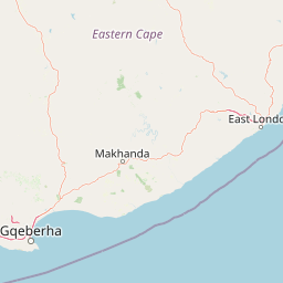
Map view of Tsolwana Nature Reserve

Use this park location map to pinpoint Tsolwana Nature Reserve in South Africa, understand its exact geographic position, and read its mapped placement within the surrounding landscape more clearly.

Pigeon | © OpenStreetMap contributors

Location context for Tsolwana Nature Reserve

Eastern Cape

Examine protected area views, Winterberg mountain terrain, and Karoo habitats.

Tsolwana Nature Reserve Photos and Landscape Scenery Visual Exploration

Visual documentation captures the transitional terrain, grassy plains, and acacia thornveld defining the protected landscape. Examining park imagery reveals the distinct ecological character formed where mountain slopes meet the semi-arid interior.

Blue Crane

Park atlas

Compare regional geography, mountain slopes, and semi-arid valley habitats.

Explore Parks Near Tsolwana Nature Reserve and Surrounding Protected Landscapes

Compare Tsolwana Nature Reserve with adjacent protected areas across the Eastern Cape to understand regional conservation zones. Examining nearby parks reveals connected mountain ecosystems, transitional grasslands, and similar semi-arid habitats.
Nature reserveEastern Cape Province
About 51 km away#1 closest

South

Mpofu Nature Reserve: Mapping the Ecological Diversity of the Amatole Mountains

Protected escarpment terrain and South African biome transitions

Located in the Eastern Cape, Mpofu Nature Reserve is a significant protected landscape known for the meeting of Grassland, Forest, and Albany Thicket biomes. The terrain ranges from low valley floors to high escarpment plateaus, providing a complex habitat for diverse mammals and endemic flora in a malaria-free setting.

Area
75 km²
Established
1985
Relief
Mountain
Climate
Subtropical
National parkEastern Cape
About 91 km away#2 closest

West

Mountain Zebra National Park: A National Park within Eastern Cape's Geography

Explore its mapped protected boundaries and regional landscape context.

Mountain Zebra National Park serves as a key protected area within South Africa's Eastern Cape region. This page offers an atlas-driven perspective, detailing the park's geographic scope and mapped boundaries. Understand its role as a national park and its contribution to the regional landscape context, providing structured data for those interested in protected land distribution and natural terrain.

Area
284 km²
Established
1937
IUCN
II
Visitors
31.2K annual
Nature reserveEastern Cape
About 94 km away#3 closest

South

Great Fish River Nature Reserve: Mapping Protected Areas in the Eastern Cape of South Africa

A consolidated network of river-valley terrain and subtropical thicket ecosystems.

Spanning over 45,000 hectares, this reserve captures the essence of the Eastern Cape's dissected landscape. The protected area is defined by the Great Fish River and a series of steep, dramatic cliffs that separate distinct ecological basins. This atlas entry focuses on the reserve's unique combination of historical boundaries and its role in maintaining habitat continuity along the region's main river valley.

Area
450 km²
Established
1994
Relief
Upland
Climate
Subtropical
National parkEastern Cape
About 143 km away#4 closest

Southwest

Addo Elephant National Park: South African National Park with Diverse Protected Landscapes

Explore its geographic context and unique Big Seven megafauna habitats.

Addo Elephant National Park is a crucial protected landscape within South Africa's Eastern Cape, covering approximately 1,640 square kilometers of varied terrain including karoo plains, coastal dunes, and marine protected areas. Its identity is deeply tied to the successful recovery of elephant populations and its distinction as the only African national park where all Big Seven megafauna can be observed in their natural surroundings. Discover the park's geographic spread, landscape diversity, and its role as a premier conservation area.

Area
1,640 km²
Established
1931
IUCN
II
Visitors
305.5K annual
Wildlife reserveEastern Cape
About 151 km away#5 closest

South

Shamwari Game Reserve: An Atlas View of Restored Bushveld and Conservation Landscapes

Examining protected terrain within South Africa's Eastern Cape

Shamwari Game Reserve occupies approximately 250 square kilometers of restored Eastern Cape terrain. As a focal point of the Indalo Protected Environment, the reserve provides a structured habitat for diverse wildlife species and represents a significant case study in regional land reclamation and conservation mapping.

Area
250 km²
Established
1992
Relief
Upland
Scope
Terrestrial
Wildlife reserveEastern Cape
About 166 km away#6 closest

Southeast

Inkwenkwezi Private Game Reserve: Wildlife Reserve and Regional Landscape Geography

A protected multi-biome territory in South Africa's Eastern Cape region

Inkwenkwezi Private Game Reserve represents a critical study in compressed ecological diversity. Within its 4,500-hectare boundary, the property demonstrates the transition between coastal Wild Coast influences and inland forests. This overview details the reserve's unique biome convergence and its place within the broader protected geography of the Eastern Cape, providing insight into the land use and wildlife habitat structure.

Area
45 km²
Established
1983
Access
Access unknown
Scope
Terrestrial
National parkEastern Cape
About 172 km away#7 closest

West

Camdeboo National Park: Protected Landscape Atlas and Eastern Cape Geographic Context

Discover the mapped geography and protected area identity of this Eastern Cape national park.

Camdeboo National Park represents a key protected landscape within the Eastern Cape province of South Africa. This entry provides essential details for understanding its protected-area status, geographic footprint, and its role within the regional atlas. Examine its mapped boundaries and explore the unique natural terrain it encompasses, gaining specific insight into its protected landscape characteristics.

Area
194.05 km²
Established
2005
Relief
Mountain
Climate
Arid
National parkEastern Cape
About 174 km away#8 closest

Northeast

Grassland National Park National Park: Exploring Protected Landscapes and Regional Geography

Mapped boundaries and natural terrain context for an Eastern Cape protected area.

Grassland National Park represents a crucial protected area within South Africa's Eastern Cape province. As a national park, it offers significant insights into the region's natural landscapes and geographic character. This atlas perspective focuses on understanding the park's mapped scope, its terrain features, and its place within the broader provincial geography. Discover the unique protected landscape identity of Grassland National Park and how it contributes to the mapped natural heritage of the Eastern Cape.

Area
102.25 km²
Established
2025
IUCN
II
Relief
Mountain

Common questions about visiting, size, designation, and location context for Tsolwana Nature Reserve

Tsolwana Nature Reserve FAQs for park facts, access, geography, and protected area context

Find quick answers about Tsolwana Nature Reserve, including protected-area facts, park geography, trail and visitor context, and how the park fits into its surrounding country and regional landscape.
MoriAtlas Explorer

Continue Your Protected Areas Search Across the Global Atlas

Deepen your exploration by continuing the structured search for national parks and protected areas worldwide. Utilize the comprehensive filtering capabilities to compare different conservation landscapes and refine your understanding of global park geography. Discover more about the distribution and characteristics of protected natural areas.

Global natural geography