Mori Atlas logo
Nature reserveTurian-Chay State Reserve

A vital ecological refuge safeguarding juniper and pistachio forests across the rugged Boz-Dag mountain ridges.

Turian-Chay State Reserve: Mapping Protected Foothill Woodlands and Arid Landscapes in Central Azerbaijan

Turian-Chay State Reserve protects a rare and fragile ecosystem of arid light forest situated along the southern foothills of the Greater Caucasus. Spanning the Agdash District, this reserve preserves a complex terrain of narrow valleys, semi-desert plateaus, and erosion-prone slopes that provide critical habitat for regional wildlife. As a sheltered corridor, the landscape serves as an essential winter range for species descending from higher elevations, maintaining biological diversity within a distinct climatic zone.

arid forestpistachio forestjuniper woodlandsemi-desertCaucasus foothillssoil conservation

Turian-Chay State Reserve

Nature reserve

Park overview

Structured park overview, official facts, and landscape profile for Turian-Chay State Reserve

Turian-Chay State Reserve park facts, protected area profile, and essential visitor context

Review the core facts for Turian-Chay State Reserve, including designation, size, terrain, visitor scale, habitats, and operating context in one park-focused overview.

About Turian-Chay State Reserve

Turian-Chay State Reserve sits in the heart of Azerbaijan, just south of the Greater Caucasus mountain system, where the foothills begin to flatten into the country's central lowlands. The reserve covers a long, narrow band of terrain on the right bank of the Turian-Chay river, running through the Agdash district and reaching into parts of neighboring Yevlax district. This positioning gives the protected area a transitional character, bridging the rugged Caucasus slopes and the drier lowlands that stretch further south.

The protected landscape is dominated by the Boz-Dag (also written Buz-Dag) Ridge and its offshoots. Low mountains and ridges such as Pirsei-Dag, Nulbon-Dag, Archan-Dag, and Olmes-Dag rise between 400 and 650 meters above sea level and are separated by deep, narrow valleys. Northern-facing slopes are gentler and carry most of the forest cover, while southern-facing slopes are steeper, more exposed, and significantly eroded. Wind erosion has been a long-standing issue across the reserve, shaping both its scenery and the challenge the protected area was created to address.

Vegetation in the reserve is unusually varied for such a dry environment. Sparse woodlands of pistachio, juniper, and Georgian oak give way to semi-desert plant communities, riparian tugay vegetation along former river channels, and patches of pomegranate, ash, Caucasian hackberry, poplar, willow, and alder. juniper and pomegranate are both listed in the Red Book for their conservation importance.

Beyond its botanical value, Turian-Chay provides important habitat for wildlife. Mammals such as wild boar, brown bear, lynx, European wild cat, jackal, stone marten, badger, and hare live in the reserve, while birdlife includes partridges, pigeons, common kestrels, Eurasian griffon vultures, and cinereous vultures. Reptiles such as the Levantine viper and the spur-thighed tortoise also occur, the latter being protected under the Red Book. The reserve serves as especially important winter range, as animals escape severe weather on the higher Caucasus slopes by descending into its milder foothills.

Quick facts and research context for Turian-Chay State Reserve

Turian-Chay State Reserve is a strict nature reserve in central Azerbaijan, located on the southern foothills of the Greater Caucasus along the Turian-Chay river in the Agdash district. It was established on 6 May 1958 with an initial area of 126.3 square kilometers and expanded to 225 square kilometers in January 2003.

The reserve lies between 400 and 650 meters above sea level, stretching about 35 kilometers east to west and roughly 5 kilometers north to south. It protects arid light forests dominated by pistachio and juniper, semi-desert vegetation, and tugay plant communities, while also providing habitat for more than two dozen mammal species and over a hundred bird species, including Red Book-listed plants and animals.

Protection and recognition

Examine documented terrestrial conservation frameworks and designation history.

Turian-Chay State Reserve Protection Status and International Recognition Facts

Turian-Chay State Reserve maintains a documented terrestrial protection scope within the regional conservation network. Review structured records detailing the official conservation status and administrative designation metrics.

Protection details

Protection scope
Terrestrial
Transboundary protection
No
Park context

Deeper park guide and search-rich context for Turian-Chay State Reserve

Turian-Chay State Reserve history, landscape, wildlife, and travel context

Explore Turian-Chay State Reserve through its history, landscape character, ecosystems, wildlife, conservation priorities, cultural context, and seasonal travel timing in a structured park guide built for atlas discovery and search intent.

Why Turian-Chay State Reserve stands out

Turian-Chay is best known for its pistachio and juniper arid light forests, a fragile and increasingly rare woodland type that survives on the dry foothills of the Greater Caucasus. The reserve represents one of Azerbaijan's most important refuges for this kind of open, drought-adapted woodland, alongside its semi-desert plateaus and erosion-prone mountain slopes. Within Azerbaijan's system of strict nature reserves, Turian-Chay stands out as the central example of foothill arid forest protection. Its significance also extends to wildlife, since the reserve offers a sheltered winter habitat for mammals and birds that descend from the harsher high Caucasus during the cold months, making it a year-round refuge in a region where survival conditions are otherwise marginal.

Turian-Chay State Reserve history and protected-area timeline

The Turian-Chay State Reserve was officially created on 6 May 1958 in the Agdash and Yevlax districts of Azerbaijan. Its original area covered 126.3 square kilometers and was established with two clear goals: protecting and restoring arid light forests and other natural resources, and reducing the spread of erosion in the foothill zone.

The reserve's early decades were marked by serious conservation concerns. Although many of the tree species in the area were productive overall, the natural regeneration of pistachio and juniper forests was extremely slow, and erosion continued to threaten the limited soil resources of the dry slopes. Over time, the protected status of the area is reported to have had a stabilizing effect on this situation.

In January 2003, the reserve was significantly enlarged, expanding to roughly 225 square kilometers. This expansion strengthened its role in preserving the broader Boz-Dag landscape and provided more space for forest regeneration. Today, the reserve operates under the authority of Azerbaijan's Ministry of Ecology and Natural Resources and is classified as a Category Ia strict nature reserve within the framework of state nature reserves in Azerbaijan.

Turian-Chay State Reserve landscape and geographic character

The landscape of Turian-Chay State Reserve is shaped by the southern foothills of the Greater Caucasus and the structural ridges that descend from them. The reserve lies on the spurs of the Boz-Dag Ridge, with elevations ranging from about 400 to 650 meters above sea level. The territory extends roughly 35 kilometers from east to west but only about 5 kilometers from north to south, giving it an elongated shape that mirrors the underlying mountain structure.

Low mountains dominate the relief, with named peaks such as Pirsei-Dag at 609 meters, Olmes-Dag at 544 meters, Archan-Dag at 476 meters, and Nulbon-Dag at 437 meters. These hills and ridges typically have steep slopes, often denuded and eroded in places, and are separated from one another by deep, narrow valleys. Northern-facing slopes are gentler and support most of the woodland cover, while southern-facing slopes are steeper, more exposed, and far more affected by erosion.

Wind erosion is a major formative force across the reserve, especially where vegetation is sparse or has been lost historically. The interplay of bare ridges, eroded slopes, and wooded northern flanks creates a strikingly varied terrain within a relatively small elevation band, and it is precisely this combination of features that the reserve was set up to safeguard.

Turian-Chay State Reserve ecosystems, habitats, and plant life

Turian-Chay protects an unusual mosaic of dry-land ecosystems rarely preserved elsewhere at this scale in Azerbaijan. Around 73 percent of the reserve is covered by forest belts, while the remaining areas are open and largely treeless, creating a distinctive patchwork of dry woodland, semi-desert, and erosion-exposed slopes.

The defining vegetation type is arid light forest, a sparse and open woodland dominated by pistachio, several species of juniper, and Georgian oak. Other characteristic tree and shrub species include ash, Caucasian hackberry, pomegranate, and locally poplar, willow, alder, and Elaeagnus along watercourses. About 60 species of trees and shrubs grow within the reserve, and both juniper and pomegranate are listed in the Red Book for their conservation value. Junipers in particular are described as relict trees from the Tertiary period, with four of the six juniper species known in Azerbaijan occurring inside the reserve.

Beyond the forests, the reserve also protects semi-desert vegetation and tugay plant communities along former riverbeds and channels. Where forest cover was lost in the past, recovering areas now feature sagebrush, grasses, perennial and varied juniper shrubs, oak, elm, poplar, alder, willow, Elaeagnus, and other species, contributing to active soil stabilization. The Pirsei and Olmes peaks frame typical examples of these protected plant communities.

Turian-Chay State Reserve wildlife and species highlights

The wildlife of Turian-Chay is moderate in overall numbers but unusually varied in composition, reflecting the reserve's position between dry lowland and forested foothill habitats. Twenty-four mammal species, around 112 bird species, about 20 reptile species, and 3 amphibian species have been recorded across the reserve, with a slightly different and lower set of confirmed breeding species in more recent counts.

Larger mammals in the reserve include wild boar and brown bear, while medium-sized predators and omnivores such as lynx, European wild cat, jackal, stone marten, badger, and fox share the same landscape. Smaller mammals include hare and various rodent species. In winter, harsh conditions higher up in the Greater Caucasus drive many of these animals down into the reserve's milder foothills, making it one of the most favorable winter habitats in the region and offering a critical refuge during the snow season.

Birdlife is well represented, with partridges, common kestrels, pigeons, Eurasian griffon vultures, and cinereous vultures among the species present. Some bird species, including certain partridges and vultures, are flagged for conservation concern. Reptiles include the Levantine viper (Macrovipera lebetina), along with Caspian turtles along former riverbeds and spur-thighed tortoises on the slopes, both of which have Red Book status alongside the Caucasian whip snake (Coluber caucasicus).

Turian-Chay State Reserve conservation status and protection priorities

Turian-Chay State Reserve is classified as a Category Ia strict nature reserve under Azerbaijan's national system of state nature reserves, indicating a high level of protection focused on preserving natural processes with minimal intervention. Its central conservation purpose is the protection and restoration of arid light forest, particularly the pistachio and juniper woodlands that are otherwise vulnerable to overexploitation and slow regeneration.

A major part of the reserve's importance lies in soil and watershed protection. The foothill zone historically suffered from wind and water erosion, and the continued presence of pistachio, juniper, oak, and other woody vegetation is essential for holding soil in place, regulating local climate, and protecting water resources in the Turian-Chay river basin. Juniper stands are noted as having a particularly strong purifying effect, with a single hectare of juniper forest estimated to clean the air of a small industrial city.

The reserve is also a critical winter refuge for wildlife that migrates between elevations, supporting both resident populations and seasonal visitors from the higher Caucasus. Long-term effects of protection over several decades are reported to include expansion of pistachio and juniper forest cover, improved regeneration of trees, replacement of juniper by pistachio slowing significantly, and overall reduction of soil erosion processes.

Top sights and standout views in Turian-Chay State Reserve

Turian-Chay's defining trait is its preservation of pistachio and juniper arid light forest on the dry southern foothills of the Greater Caucasus, one of the most distinctive and threatened woodland types in the region. The reserve combines rocky low mountains, narrow valleys, semi-desert plateaus, and tugay vegetation within a relatively narrow elevation band of 400 to 650 meters, creating an unusually compact ecological cross-section.

Wildlife highlights include brown bear, lynx, wild boar, griffon vultures, and Red Book-listed reptiles such as the spur-thighed tortoise and the Levantine viper. The reserve's winter role, providing shelter when higher elevations become inhospitable, gives it year-round ecological importance.

Best time to visit Turian-Chay State Reserve

The Turian-Chay State Reserve sits in a zone of mild, warm climate with dry winters, which influences both landscape character and wildlife activity. Spring is typically when vegetation recovers most visibly after the dry winter, native plants come into flower, and wildlife becomes more active across the slopes and valleys, making it a particularly favorable season for observing the reserve's natural character.

Autumn offers a quieter and more relaxed atmosphere, with stable weather and softened light across the eroded ridges and forested valleys. Winter brings the reserve's most distinctive ecological role, as wildlife from higher elevations concentrates in its milder foothills, although conditions can be cold and dry. Summer tends to be the harshest and driest period, with high erosion exposure and limited surface water, making it less suitable for casual exploration.
Monthly climate preview

Long-term representative temperature and precipitation rhythms across the protected area

Turian-Chay State Reserve Climate Normals and Annual Weather Patterns

Representative coordinate records show measured monthly temperature variations and precipitation rates across a multi-year climatology baseline. Analyzing the full twelve-month dataset reveals broader climate trends and detailed seasonal normals for the protected landscape.
Annual mean12 °C
0 °C25 °C
Jan
Feb
Mar
Apr11°
May17°
Jun22°
Jul25°
Aug24°
Sep19°
Oct13°
Nov
Dec
Warmest month
July

24.7 °C

Coolest month
January

-0.2 °C

Wettest month
May

1.1 mm/day

Driest month
December

0.5 mm/day

Park location guide

Geography guide, regional context, and park location map for Turian-Chay State Reserve

Turian-Chay State Reserve park geography, regions, and map view in Azerbaijan

Understand where Turian-Chay State Reserve sits in Azerbaijan through a broader geographic reading of the surrounding landscape, nearby location context, and its mapped position within the national park landscape.

How Turian-Chay State Reserve fits into Azerbaijan

Azerbaijan is a unitary semi-presidential republic and one of six independent Turkic states. It declared independence from the Soviet Union in 1991 after nearly seven decades of Soviet rule. The country occupies 86,600 km² and has a population of approximately 10.3 million. It is known for its strategic location at the crossroads of Europe and Asia, its oil industry heritage, and its diverse cultural influences from Persian, Russian, and Turkic traditions.

Wider geography shaping Turian-Chay State Reserve in Azerbaijan

Azerbaijan occupies the eastern portion of the Caucasus region, situated between the Caspian Sea to the east and the Greater Caucasus mountains to the north. The terrain is diverse, featuring lowlands along the Caspian coast, mountainous areas in the north and west, and semi-desert plains in the central regions. The Kura and Aras rivers are major waterways draining into the Caspian Sea.

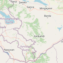
Map view of Turian-Chay State Reserve

Use this park location map to pinpoint Turian-Chay State Reserve in Azerbaijan, understand its exact geographic position, and read its mapped placement within the surrounding landscape more clearly.

Pigeon | © OpenStreetMap contributors

Location context for Turian-Chay State Reserve

Agdash District
Park atlas

Compare regional park geography and adjacent protected landscapes across the Caucasus foothills

Explore Parks Near Turian-Chay State Reserve and Surrounding Protected Areas

Browse nearby national parks and protected areas sharing the rugged terrain, arid light forests, and wildlife migration corridors of central Azerbaijan. Comparing adjacent reserves reveals the broader ecological links uniting the southern slopes of the Greater Caucasus.
Watercolor painting of layered mountains with green, yellow, and pink hues.
National parkAzerbaijan
About 73 km away#1 closest

East

Shahdag National Park: Azerbaijan's Largest National Park and Highest Mountain Landscape

Explore the Greater Caucasus protected area and its unique ecosystems.

Shahdag National Park is the largest protected area in Azerbaijan, encompassing a significant portion of the Greater Caucasus mountain range. This national park is renowned for its dramatic elevation changes, creating diverse ecosystems that transition from dense, old-growth montane forests to high-alpine meadows and rugged, rocky summits. The park's landscape is defined by its towering peaks, including Mount Bazardüzü, the nation's highest point, and provides critical habitat for endemic species like the East Caucasian tur. Use this page to begin your atlas-based exploration of Shahdag National Park's protected geography and its distinctive natural terrain.

Area
1,305.08 km²
Established
2006
IUCN
II
Relief
Mountain
Watercolor painting showing green hills, a river, and distant purple and orange mountains
National parkDedoplistsqaro Municipality
About 75 km away#2 closest

Northwest

Vashlovani National Park: Georgia's Unique Lowland Desert and Badland Protected Landscape

Discover distinct semi-arid terrain and rare forest ecosystems.

Vashlovani National Park in Dedoplistsqaro Municipality represents a significant protected area preserving Georgia's rare lowland desert and semi-arid steppe ecosystems. This national park is characterized by its striking badland topography, known as the "Sharp Walls," wild pistachio forests, and riparian habitats along the Alazani River. Its unique geographic setting, far removed from Georgia's typical mountainous landscapes, makes Vashlovani a crucial site for understanding regional biodiversity and conservation within the Caucasus.

Area
442.51 km²
Established
1935
IUCN
II
Relief
Lowland
National parkAzerbaijan
About 87 km away#3 closest

South

Ag-Gel National Park

Azerbaijan Protected Wetland & Bird Sanctuary

Ag-Gel National Park is a protected wetland significant for migratory birds. Its landscape features a complex lake system and extensive reed beds, making it a vital conservation area in the Caspian region.

Area
179.24 km²
Established
2003
IUCN
II
Relief
Lowland
Watercolor illustration of a lake surrounded by greenery with mountains in the background
National parkAzerbaijan
About 101 km away#4 closest

Southwest

Göygöl National Park: Iconic Alpine Lakes and Protected Caucasus Forest Landscape

Explore Azerbaijan's most visited national park and its rich geographic context.

Göygöl National Park is a key protected area in Azerbaijan, renowned for the crystal-clear alpine Lake Göygöl and its surrounding dense forests within the Lesser Caucasus mountains. This national park showcases over 420 plant species, significant wildlife populations, and dramatic mountainous terrain, making it a prime destination for understanding regional landscape diversity and protected land value. Use MoriAtlas to explore its mapped boundaries and connect it to the broader geographic context of Azerbaijan.

Area
127.55 km²
Established
2008
IUCN
II
Relief
Mountain
National parkAzerbaijan
About 125 km away#5 closest

East

Altyaghach National Park: Azerbaijan's Protected Natural Area & Forested Geography

Explore the mapped boundaries and temperate deciduous forests.

Altyaghach National Park is a key protected area in Azerbaijan, safeguarding a significant portion of the Greater Caucasus's temperate deciduous broadleaved forest ecosystems. Covering over 11,000 hectares, the park is instrumental in preserving biodiversity and restoring natural habitats, notably providing refuge for the rare East Caucasian tur and other protected species. Its landscape, characterized by rolling to steep terrain and diverse forest cover reaching approximately 941 meters in elevation, makes it a representative example of Caucasus mountain conservation within the country.

Area
110.35 km²
Established
2004
IUCN
II
Relief
Mixed relief
Nature reserveZagatala District
About 132 km away#6 closest

Northwest

Zagatala State Reserve: Protected Mountain Geography and Forested River Valleys in Northern Azerbaijan

Ancient broadleaf woodlands within the Greater Caucasus mountain range.

Zagatala State Reserve protects a critical mountainous region in northern Azerbaijan, known for its extensive oak and beech forests, rugged karst formations, and dramatic river-carved topography. The area supports rare Caucasian fauna and offers an intact look at the natural landscape transitions from forested foothills to high mountain meadows.

Established
1929
National parkKhachmaz Rayon
About 152 km away#7 closest

Northeast

Samur-Yalama National Park: Caspian Coastal Forest Protected Area

Mapped protected landscape in Azerbaijan's Khachmaz Rayon.

Delve into the protected geography of Samur-Yalama National Park, a key national park established in 2012 within Azerbaijan's Khachmaz Rayon. This 11,772-hectare area meticulously preserves vital Caspian coastal forest ecosystems, characterized by dominant chestnut oak and Persian ironwood stands. The park’s diverse terrain ranges from littoral zones to inland steppe, offering significant insights into regional landscape context and protected area management for atlas exploration and geographic analysis.

Area
117.72 km²
Established
2012
IUCN
II
Relief
Mixed relief
National parkDagestan
About 154 km away#8 closest

Northeast

Samursky National Park: National Park Protected Landscape and Geographic Atlas

Explore Dagestan's Samursky National Park mapped terrain.

Gain a structured understanding of Samursky National Park, a key national park within Russia's Dagestan region. This page focuses on its protected landscape identity, mapped boundaries, and its place within the regional geography of the North Caucasus. Use this atlas-centric view to comprehend the park's contribution to Dagestan's natural terrain and conservation landscape.

Area
483 km²
Established
2019
IUCN
II
Relief
Mixed relief

Common questions about visiting, size, designation, and location context for Turian-Chay State Reserve

Turian-Chay State Reserve FAQs for park facts, access, geography, and protected area context

Find quick answers about Turian-Chay State Reserve, including protected-area facts, park geography, trail and visitor context, and how the park fits into its surrounding country and regional landscape.
MoriAtlas Explorer

Continue Your Protected Areas Search Across the Global Atlas

Deepen your exploration by continuing the structured search for national parks and protected areas worldwide. Utilize the comprehensive filtering capabilities to compare different conservation landscapes and refine your understanding of global park geography. Discover more about the distribution and characteristics of protected natural areas.

Global natural geography