

Mori Atlas logo
National parkUtría National Natural Park

Discover the mapped boundaries and regional context of this Colombian national park.

Utría National Natural Park: Protected Landscape, Geography, and Atlas Exploration

(Parque Nacional Natural Utría)

Utría National Natural Park represents a significant protected landscape within the Chocó Department of Colombia, offering rich opportunities for geographic discovery and atlas-based exploration. This page provides detailed insights into the park's protected area status, its specific geographic setting, and its mapped boundaries, allowing users to understand its unique place within the region's natural terrain.

Tropical rainforestPacific coastHumpback whalesCoral reefsMangrove forestsBiodiversity hotspot

Utría National Natural Park

National park

Park overview

Structured park overview, official facts, and landscape profile for Utría National Natural Park

Utría National Natural Park park facts, protected area profile, and essential visitor context
Review the core facts for Utría National Natural Park, including designation, size, terrain, visitor scale, habitats, and operating context in one park-focused overview.

About Utría National Natural Park

Utría National Natural Park represents one of Colombia's most ecologically significant protected areas, combining tropical rainforest, coastal marine environments, and wetland ecosystems in a single protected landscape. The park's location on the Pacific coast places it within the Chocó biogeographic region, recognized globally as a biodiversity hotspot due to its exceptionally high species richness. The Ensenada de Utría, for which the park is named, forms a natural lagoon system surrounded by grey sandy beaches and extensive mangrove forests that serve as critical nurseries for marine life. The park's mountainous interior contains old-growth forest characterized by towering trees including species such as cohíba, the symbolic tree of Chocó Department, alongside ceiba, carbonero, and guayacán. The surrounding landscape supports traditional communities including Emberá indigenous peoples who maintain cultural traditions within the park boundaries and Afro-Colombian fishing villages along the coast. The combination of pristine natural environments with living cultural heritage makes Utría a model for integrated conservation that supports both biodiversity protection and community livelihoods through ecotourism.

Quick facts and research context for Utría National Natural Park

Utría National Natural Park occupies the Pacific coast of Colombia's Chocó Department, covering parts of Bahía Solano, Nuquí, Bojayá, and Alto Baudó municipalities. The park was established in October 1987 and is administered by Colombia's National System of Protected Areas. The climate is warm and humid with mean temperatures between 23 and 30 degrees Celsius, and the area experiences rain on over 300 days each year. The landscape transitions from coastal mangroves and beaches through lowland rainforest to premontane forest on mountain slopes, supporting both terrestrial and marine protected zones.

Park context

Deeper park guide and search-rich context for Utría National Natural Park

Utría National Natural Park history, landscape, wildlife, and travel context
Explore Utría National Natural Park through its history, landscape character, ecosystems, wildlife, conservation priorities, cultural context, and seasonal travel timing in a structured park guide built for atlas discovery and search intent.

Why Utría National Natural Park stands out

Utría is renowned for its remarkable marine wildlife, most notably the seasonal presence of humpback whales that migrate to the park's coastal lagoon from June through November to give birth from August to October. The park also protects critical nesting beaches for multiple sea turtle species, including olive ridley, leatherback, hawksbill, and green turtles. The marine environment features coral reefs with 11 of the 16 coral species recorded in the Colombian Pacific, alongside more than 180 fish species and diverse marine mammals including dolphins and occasional whale visitors. On land, the rainforest shelters populations of jaguar, cougar, and other large mammals within what is considered one of the most biodiverse regions in the world.

Utría National Natural Park history and protected-area timeline

Utría National Natural Park was established in October 1987 as part of Colombia's expansion of its national park system during a period of increased environmental awareness and protected area designation. The creation of the park recognized the exceptional ecological value of the Chocó region's Pacific coast, which had remained relatively undisturbed due to its remoteness and challenging terrain. The park's establishment also acknowledged the importance of the area for local indigenous and Afro-Colombian communities whose traditional territories overlapped with the protected zone. Since its creation, management has incorporated collaborative approaches with these local communities, recognizing their role as stewards of the landscape and partners in conservation. The park's infrastructure, including the Jaibaná visitor center with accommodations, was developed to support controlled ecotourism that provides economic benefits to surrounding communities while maintaining conservation objectives.

Utría National Natural Park landscape and geographic character

The physical landscape of Utría National Natural Park encompasses a remarkable diversity of terrain within a relatively compact area. The coastal zone features the Ensenada de Utría, a substantial seawater lagoon with narrow entrances to the Pacific Ocean, surrounded by grey sand beaches and dense mangrove forests. The park rises inland through lowland rainforest into the foothills and slopes of the Baudó mountains, reaching elevations of up to 1,400 meters above sea level. Several rivers including the Condoto, Condotico, and Valle originate within the park boundaries, feeding freshwater into the coastal system. The combination of steep mountain slopes, valley floors, and coastal interfaces creates varied microhabitats that support the park's extraordinary biodiversity. The maritime environment extends offshore from the beach zone, incorporating coral reef structures along the shoreline that provide critical habitat for marine species.

Utría National Natural Park ecosystems, habitats, and plant life

The ecological character of Utría is defined by its location within the Chocó region, one of the world's most pluvial zones with annual rainfall exceeding 10,000 millimeters in some areas. This extreme precipitation supports dense rainforest vegetation across all accessible terrain, from sea-level mangroves through lowland forest to premontane formations on higher ground. The park contains seven of the ten mangrove species found along the Colombian Pacific coast, creating extensive wetland ecosystems at the coastal interface. Coral reef communities along the shoreline support exceptional marine diversity, with 11 coral species representing significant portions of the regional Pacific reef fauna. The forest environment includes valuable timber species and culturally important plants such as chontaduro and mil peso palms that provide food for local communities, while iraca palm is traditionally used for craft production. The combination of terrestrial and marine protected zones within a single management unit creates ecological connectivity essential for species that move between forest and ocean environments.

Utría National Natural Park wildlife and species highlights

Utría supports impressive terrestrial fauna including large mammals such as jaguar and cougar, representing apex predators in the forest ecosystem. The park shelters populations of medium-sized mammals including brocket deer, collared peccary, white-lipped peccary, and lowland paca, alongside primates such as mantled howler monkey and black-headed spider monkey that occupy the forest canopy. Notable specializations include giant anteater, brown-throated sloth, and Central American agouti. The avifauna is exceptionally diverse with approximately 380 bird species recorded throughout the forest strata, representing one of the richest bird communities in Colombia. Marine wildlife features multiple sea turtle species that use the park's beaches for nesting, particularly olive ridley turtles at Cuevita beach, while leatherback, hawksbill, and green turtles appear sporadically. Humpback whales visit the coastal waters from June through November, using the sheltered lagoon for calving during the peak season from August to October. Dolphins are present year-round, and occasional visitors include sperm whales, killer whales, and Risso's dolphins. The marine fish community exceeds 180 species ranging from small gobies to the enormous whale shark.

Utría National Natural Park conservation status and protection priorities

Utría National Natural Park plays a critical role in protecting one of Earth's most biologically rich yet threatened regions. The Chocó Pacific coast has experienced accelerating deforestation from agricultural expansion, logging, and mining, making protected areas like Utría essential refuges for species that cannot survive in fragmented landscapes. The park's dual protection of terrestrial and marine environments addresses a common gap in conservation planning, as coastal ecosystems often receive inadequate protection relative to inland areas. The presence of key biodiversity elements including jaguar, sea turtles, and marine mammals, combined with significant coral reef communities, places Utría among Colombia's most important protected areas for marine conservation. The collaborative management approach involving Emberá indigenous communities and Afro-Colombian populations demonstrates a conservation model that integrates human communities as partners rather than excluding them, potentially improving long-term protection outcomes through local stewardship.

Utría National Natural Park cultural meaning and human context

The cultural landscape of Utría encompasses two distinct but coexisting communities whose relationships with the environment shape the park's human context. The Emberá indigenous people maintain traditional territories within the park boundaries, preserving cultural practices and environmental knowledge accumulated over generations. Their cultural traditions remain well-preserved and they participate actively in park management and ecotourism services. Along the coast, Afro-Colombian fishing communities have established villages that reflect the unique cultural heritage of communities descended from enslaved Africans who settled this remote section of Colombia's Pacific coast. Both indigenous and Afro-Colombian communities maintain strong orientations toward environmental conservation, viewing the landscape through cultural frameworks that emphasize sustainable resource use. The park's management recognizes these communities as essential partners, with ecotourism services provided through the non-profit organization Corporación Mano Cambiada, representing a model where conservation supports community livelihoods while community knowledge supports protection efforts.

Top sights and standout views in Utría National Natural Park

Utría National Natural Park offers exceptional biodiversity concentrated in a relatively accessible Pacific coast setting. The seasonal arrival of humpback whales provides a world-class wildlife viewing opportunity as these massive cetaceans use the protected lagoon for calving during the late summer and fall months. The marine environment supports coral reefs, diverse fish communities, and regular dolphin populations that can be observed through snorkeling, swimming, and diving activities. The forest interior contains viable populations of large cats including jaguar and cougar, though seeing these secretive animals requires patience and luck. The network of trails through varying forest types provides access to waterfalls, wildlife observation points, and scenic viewpoints across the coastal to mountain gradient. The combination of pristine natural environments with the opportunity to experience Emberá and Afro-Colombian cultural traditions through community-managed ecotourism distinguishes Utría from typical protected area visits.

Best time to visit Utría National Natural Park

The optimal time to visit Utría depends on which wildlife experiences priority, as different seasons favor different activities. Humpback whale viewing peaks from August through October when mothers and calves are most commonly observed in the lagoon, making this the prime season for cetacean enthusiasts. The rainy season runs throughout the year with over 300 rainy days annually, but October typically sees the highest precipitation while February represents the relatively driest period. The wet conditions mean rain gear is essential year-round, though the consistently warm temperatures ranging from 23 to 30 degrees Celsius make the climate comfortable despite the precipitation. Sea turtle nesting occurs primarily during specific seasons, with olive ridleys most reliably observed at Cuevita beach. The park remains open year-round, though conditions during the wettest months may challenge some visitors. The warm and humid tropical climate means the experience of visiting remains consistently tropical regardless of when travelers arrive.

Park location guide

Geography guide, regional context, and park location map for Utría National Natural Park

Utría National Natural Park park geography, regions, and map view in Colombia
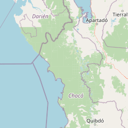
Understand where Utría National Natural Park sits in Colombia through a broader geographic reading of the surrounding landscape, nearby location context, and its mapped position within the national park landscape.

How Utría National Natural Park fits into Colombia

Colombia is a presidential republic located in the northern part of South America. It spans approximately 1.14 million km² and has a population of around 52 million. The country features the Andes mountain range, extensive Amazon rainforest, and coastal regions on both the Caribbean and Pacific. Spanish is the official language, and Bogotá serves as the capital and largest city.

Wider geography shaping Utría National Natural Park in Colombia

Colombia is located in the northwestern part of South America, bordering the Caribbean Sea to the north and the Pacific Ocean to the west. Its mainland neighbors are Venezuela to the east, Brazil to the southeast, Peru and Ecuador to the south and southwest, and Panama to the northwest. The terrain is diverse, featuring the Andes mountain range in the west, Amazon rainforest in the south and east, and coastal plains along both oceans.

Map view of Utría National Natural Park

Use this park location map to pinpoint Utría National Natural Park in Colombia, understand its exact geographic position, and read its mapped placement within the surrounding landscape more clearly.

Pigeon | © OpenStreetMap contributors

Location context for Utría National Natural Park

Chocó Department
Park atlas

Trace connected protected landscapes and regional park geography across Colombia's biodiverse Pacific coast.

Compare National Parks and Protected Areas Near Utría National Natural Park
Users exploring Utría National Natural Park can browse nearby national parks and protected areas within Colombia's Chocó Department, identifying shared coastal and rainforest ecosystems. This module allows geographical comparison of protected marine environments and mountainous rainforests, revealing the full scope of regional conservation efforts beyond a single park.
National parkColombia

Las Orquídeas National Natural Park: Colombia's Biodiversity Hotspot and Andean Ecosystem Atlas

Explore its unique elevational gradient and protected terrain.

Las Orquídeas National Natural Park in Colombia is renowned for its dramatic elevational range, compressing multiple distinct ecosystems into a single protected area. This national park offers an exceptional view of Andean geography and Chocó biogeographic region biodiversity, transitioning from tropical rainforest to high-altitude páramo. Investigate the mapped landscape and the conservation significance of this unique natural treasure.

Area
287.53 km²
Established
1974
IUCN
II
Relief
Mountain
National parkColombia

Tatamá National Natural Park: Colombia's Protected Natural Landscape Explorer

Mapped boundaries and regional geography of a Colombian national park.

Tatamá National Natural Park is a protected natural area situated within the Republic of Colombia. As a designated national park, it contributes significantly to the nation's protected lands. This entry provides essential geographic context, focusing on the park's mapped outlines and its role within the broader atlas of Colombian geography. Understanding Tatamá National Natural Park involves appreciating its specific landscape features and its contribution to the country's network of protected natural areas, offering a foundation for regional geographic study.

Area
519 km²
Established
1987
IUCN
II
Relief
Mountain
National parkDarién Province

Darién National Park: Darién Province National Park Geographic and Map Exploration

Discover its protected landscape and regional geographic context.

Darién National Park serves as a key protected area within Darién Province, offering an essential focus for geographic and atlas-based discovery. This dedicated park detail page provides insights into its mapped boundaries and its significance as a national park. Users can explore the park's specific geographic footprint and its place within the regional landscape, facilitating a structured understanding of protected natural areas. Dive into the mapped terrain and conservation landscape context that defines Darién National Park for comprehensive atlas exploration.

Area
5,790 km²
Established
1980
IUCN
II
Relief
Mountain
National parkValle del Cauca Department

Uramba Bahía Málaga National Natural Park: National Park Protected Landscape and Geography

Explore mapped natural terrain and protected boundaries.

Gain a detailed atlas understanding of Uramba Bahía Málaga National Natural Park, a designated national park in Colombia's Valle del Cauca Department. This page details its protected landscape features and geographic setting, offering insights into its mapped boundaries and regional context for dedicated geographic exploration.

Area
471 km²
Established
2010
IUCN
II
Climate
Tropical
National parkColombia

Los Nevados National Natural Park: Colombia's National Park and Protected Landscape

Detailed map context and protected land geography.

Los Nevados National Natural Park serves as a key protected area within Colombia, offering rich opportunities for geographic discovery. This page details the park's mapped boundaries and its contribution to the broader atlas of South American protected lands. Explore the unique landscape character and regional geographic significance that define Los Nevados National Natural Park as a vital natural reserve.

Area
583 km²
Established
1973
IUCN
II
Visitors
39.9K annual
Watercolor painting of green hills, trees, and distant mountains under a light sky
National parkValle del Cauca Department

Farallones de Cali National Park: Protected Landscape and Geographic Atlas

Explore mapped boundaries and regional context.

Farallones de Cali National Park offers a distinct protected landscape within Valle del Cauca Department. This page provides atlas-level detail on its geographic scope and mapped features, crucial for understanding its regional context. Dive into the protected-area specifics to grasp the natural terrain and conservation landscape that defines this significant Colombian national park.

Area
1,500 km²
Established
1968
IUCN
II
Relief
Mountain
National parkCauca Department

Munchique National Natural Park: National Park with Key Protected Landscape Features

Explore mapped geography and protected area context.

Munchique National Natural Park is a designated National Park offering a distinct protected landscape within Colombia's Cauca Department. This page provides essential context for understanding its geographic footprint, regional setting, and its significance as a mapped natural area. Dive into the atlas details and explore the unique geography that defines this protected entity.

Area
440 km²
Established
1977
IUCN
II
Relief
Mountain
National parkPanama

Cerro Hoya National Park: Panama's Protected Landscape with Mapped Geographic Detail

Explore the national park's mapped boundaries and regional atlas context.

Cerro Hoya National Park presents a unique opportunity for geographic discovery, focusing on its role as a protected landscape within Panama. This park detail page allows for an in-depth atlas-style exploration of its mapped boundaries and its contribution to the regional geography of Central America. Understand the protected-area identity and the natural context that defines this significant national park, providing valuable data for landscape analysis and map-based research.

Area
333.4 km²
Established
1984
IUCN
II
Relief
Mountain

Common questions about visiting, size, designation, and location context for Utría National Natural Park

Utría National Natural Park FAQs for park facts, access, geography, and protected area context
Find quick answers about Utría National Natural Park, including protected-area facts, park geography, trail and visitor context, and how the park fits into its surrounding country and regional landscape.
MoriAtlas Explorer

Continue Your Protected Areas Search Across the Global Atlas

Deepen your exploration by continuing the structured search for national parks and protected areas worldwide. Utilize the comprehensive filtering capabilities to compare different conservation landscapes and refine your understanding of global park geography. Discover more about the distribution and characteristics of protected natural areas.

Global natural geography