Mori Atlas logo
Nature reserveVallée de l'Aulne

Examining the ecological corridors, watershed boundaries, and protected natural habitats of central Finistère.

Vallée de l'Aulne Nature Reserve: A Detailed Geographic Survey of the Aulne River Basin Landscapes

(Vallée de l'Aulne (site Natura 2000 FR5300041))

The Vallée de l'Aulne represents a vital riverine ecosystem that defines the inland terrain of central Finistère in Brittany. This protected area tracks the winding course of the Aulne as it drains toward the Rade de Brest, supporting diverse freshwater habitats and essential corridors for protected species. Our geographic analysis provides a clear perspective on the valley's physical boundaries, riparian woodland patches, and the convergence of protected status within this iconic French watershed.

natura 2000river valleyfreshwater habitatsestuaryAtlantic salmonEuropean otter

Vallée de l'Aulne

Nature reserve

Park overview

Structured park overview, official facts, and landscape profile for Vallée de l'Aulne

Vallée de l'Aulne park facts, protected area profile, and essential visitor context

Review the core facts for Vallée de l'Aulne, including designation, size, terrain, visitor scale, habitats, and operating context in one park-focused overview.

About Vallée de l'Aulne

The Vallée de l'Aulne occupies the central third of Finistère and roughly corresponds to the arrondissement de Châteaulin. Its landscape is defined by a low-lying river corridor that gathers waters from the surrounding Breton countryside before discharging into the Rade de Brest, an inland sea connected to the Atlantic through the Mer d'Iroise. Administratively the basin spans about 1,892 square kilometers across 90 communes managed under a unified water plan since 2008.

As a protected area, the valley sits at the meeting point of several conservation frameworks. It is one of four major territories of the Parc naturel régional d'Armorique, and it is covered by a stack of Natura 2000 sites including the valley's own habitat directive site, the maritime zone of the Rade de Brest and Aulne estuary, and the bird directive designation of the Baie de Daoulas and Anse de Poulmic. A dense network of ZNIEFF inventories further documents the valley's ecological value.

The Aulne is more than just a hydrological feature: it is also a focus of Breton cultural identity. Its traditional name appears in the phrase "Bro ar Ster Aon," meaning the country of the Aulne, and the river valley has long been a source of Breton-language oral literature. Today the valley combines agricultural land, woodlands, freshwater habitats, and estuarine environments, supporting both biodiversity conservation and the regional way of life along the Aulne.

Quick facts and research context for Vallée de l'Aulne

The Vallée de l'Aulne is a Natura 2000 protected zone in Brittany, centered on the Aulne river basin. It mostly lies in Finistère but extends into Côtes-d'Armor and a small portion of Morbihan. The protected valley site is formally listed as FR5300041 under the European Habitats Directive. The valley forms one of the four main territories of the Parc naturel régional d'Armorique and drains into the Rade de Brest.

Protection and recognition

Terrestrial protection scope and documented Natura 2000 recognition history

Vallée de l'Aulne Protection Status and Official Designation Record

Vallée de l'Aulne maintains a documented terrestrial protection status established in 2014 alongside recognized Natura 2000 designations. Structured records compile official designation history and international recognition sources for detailed conservation geography analysis.

International recognition

Protection details

Protection scope
Terrestrial
Designated year
2014
Transboundary protection
No
Park context

Deeper park guide and search-rich context for Vallée de l'Aulne

Vallée de l'Aulne history, landscape, wildlife, and travel context

Explore Vallée de l'Aulne through its history, landscape character, ecosystems, wildlife, conservation priorities, cultural context, and seasonal travel timing in a structured park guide built for atlas discovery and search intent.

Why Vallée de l'Aulne stands out

The valley is best known for maintaining healthy populations of Atlantic salmon, European otter, and greater horseshoe bat, three species that justified its Natura 2000 designation. It is also notable for the endemic Quimper snail, a species found only in this part of western Brittany.

Vallée de l'Aulne history and protected-area timeline

The modern history of the valley is tied to the development of coordinated river-basin management in France. In 2008, a Schéma d'aménagement et de gestion des eaux was established for the Aulne basin, administered by a public body known as the EPAGA, which coordinates water management across 90 communes. The Natura 2000 site Vallée de l'Aulne was formally designated as a Special Area of Conservation by decree on 17 February 2014.

Earlier in the twentieth century, the valley's cultural heritage was documented by Yann ar Floc'h, who collected Breton oral traditions from communities along the Aulne and later compiled them in the 1950 volume Koñchennou Bro ar Ster Aon. This collection preserves the longest known oral version of the legend of King Marc'h.

Vallée de l'Aulne landscape and geographic character

The Vallée de l'Aulne follows the course of the Aulne river as it winds through central Brittany toward the Rade de Brest. The valley is a low-elevation watershed framed by the bocage countryside typical of inland Finistère, with mixed farmland, hedgerows, woodland patches, and wet meadows along the river. Toward the coast, the freshwater valley opens into the broad tidal estuary of the Rade de Brest, where the river meets the sea between the Léon and Cornouaille regions.

Vallée de l'Aulne ecosystems, habitats, and plant life

Ecologically, the Aulne valley is defined by its freshwater habitats and the gradient from inland streams to estuarine waters. The Natura 2000 designation protects a wide range of aquatic and wetland-associated species, taking in river sections, tributaries, and the transitional zone where the Aulne meets the rade. The valley is recognized as a particularly important stronghold for migratory fish and for species that depend on clean freshwater systems and intact riverside habitat.

Vallée de l'Aulne wildlife and species highlights

The valley supports a notably rich fauna highlighted by several protected and community-interest species. Freshwater inhabitants include the Atlantic salmon, sea lamprey, European brook lamprey, allis shad, twaite shad, common bullhead, and the critically threatened freshwater pearl mussel. Amphibians are represented by the great crested newt, common toad, and fire salamander, while mammals include the European otter and Eurasian beaver.

Woodland and farmland edges hold important insect populations, among them the stag beetle and the great capricorn beetle. Several bat species are present, including the greater horseshoe bat, lesser horseshoe bat, Geoffroy's bat, Bechstein's bat, the greater mouse-eared bat, and the western barbastelle. The valley also hosts the Quimper snail, an endemic land snail restricted to a small range in western Brittany.

Vallée de l'Aulne conservation status and protection priorities

Designation as a Natura 2000 Special Area of Conservation since 2014 was justified by the presence of three community-interest species: the Atlantic salmon, the European otter, and the greater horseshoe bat. The valley is one of the four core territories of the Parc naturel régional d'Armorique, and its Habitats Directive site (FR5300041) is complemented by associated designations over the maritime waters of the Rade de Brest. River-basin management is coordinated through the EPAGA, which oversees water planning across ninety communes. The combination of European habitat, bird, and regional park protections makes the Aulne one of the most institutionally layered protected landscapes in Brittany.

Vallée de l'Aulne cultural meaning and human context

The Aulne river has long given its name to a recognizable Breton cultural region, known in Breton as Bro ar Ster Aon. In the early twentieth century, the folklorist Yann ar Floc'h (Jean Le Page) gathered oral tales from communities across the valley, later publishing them as Koñchennou Bro ar Ster Aon in 1950. This collection includes the longest known oral version of the legend of King Marc'h.

Top sights and standout views in Vallée de l'Aulne

The Vallée de l'Aulne stands out for combining a functioning Atlantic salmon river, healthy otter populations, and roosting sites for greater horseshoe bats. It is also one of the only places home to the endemic Quimper snail and is layered with overlapping protections that include the Parc naturel régional d'Armorique and several Natura 2000 sites.

Best time to visit Vallée de l'Aulne

Spring and early summer tend to bring lush green conditions along the river and active freshwater wildlife, while autumn can be a rewarding period for observing migratory fish and changing landscape colors. Estuarine areas near the Rade de Brest also attract waterbirds through the cooler months, though visitors are advised to focus on the river valley itself rather than specific seasonal logistics that are not documented in the source material.
Monthly climate preview

Long-term temperature ranges and precipitation rhythm for Vallée de l'Aulne

Vallée de l'Aulne Climate Normals and Measured Monthly Weather Patterns

Representative coordinate records show measured monthly averages ranging from cold winter minimums to warm summer maximums alongside varying daily precipitation rates. Examining the full twelve-month profile provides complete historical climate data for analytical comparison.
Annual mean12 °C
6 °C18 °C
Jan
Feb
Mar
Apr10°
May13°
Jun16°
Jul18°
Aug18°
Sep16°
Oct13°
Nov
Dec
Warmest month
August

18.1 °C

Coolest month
February

6.1 °C

Wettest month
December

3.5 mm/day

Driest month
July

1.6 mm/day

Park location guide

Geography guide, regional context, and park location map for Vallée de l'Aulne

Vallée de l'Aulne park geography, regions, and map view in France

Understand where Vallée de l'Aulne sits in France through a broader geographic reading of the surrounding landscape, nearby location context, and its mapped position within the national park landscape.

How Vallée de l'Aulne fits into France

France is a unitary semi-presidential republic and one of the world's largest economies. It borders Belgium, Luxembourg, Germany, Switzerland, Italy, Monaco, Andorra, and Spain, with a maritime border to the United Kingdom. The country is known for its cultural influence, art, cuisine, and political history spanning centuries.

Wider geography shaping Vallée de l'Aulne in France

France is located in Western Europe. Metropolitan France extends from the Rhine to the Atlantic Ocean and from the Mediterranean Sea to the English Channel and North Sea. The country borders Belgium, Luxembourg, Germany, Switzerland, Italy, Monaco, Andorra, Spain, and has a maritime border with the United Kingdom.

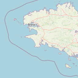
Map view of Vallée de l'Aulne

Use this park location map to pinpoint Vallée de l'Aulne in France, understand its exact geographic position, and read its mapped placement within the surrounding landscape more clearly.

Pigeon | © OpenStreetMap contributors

Location context for Vallée de l'Aulne

Finistère
Recorded earthquake history

Review Historical Earthquake Records near the Vallée de l'Aulne

Open the comprehensive catalogue to browse recorded seismic events and epicenter locations associated with this protected river valley. The MoriAtlas dataset allows for detailed historical review of activity surrounding the Vallée de l'Aulne, supporting geographic analysis of the region through reliable archival data.

Vallée de l'Aulne Earthquake History

Catalogued events

30 events

Strongest magnitude

Magnitude 3.9

Most recent event

Feb 19, 2020

This history includes earthquakes recorded inside the park or within 50 km of its borders

Park atlas

Compare adjacent river valleys and connected conservation territories across northwestern France

Parks Near Vallée de l'Aulne and Surrounding Protected Landscapes in Regional Brittany

Visitors exploring Vallée de l'Aulne can examine adjacent protected areas and neighboring river basins across western Brittany. Extending the geographic review helps map regional habitat links, shared estuarine terrain, and regional conservation networks.
A horizontal watercolor illustration of a soft green landscape with rolling hills, patches of grass, and distant tree lines against a white background.
Nature reserveBretagne
1.1 km away#1 closest

Northeast

Réserve naturelle régionale des landes et tourbières du Cragou et du Vergam: Regional Park Geography

Protected granite ridges and Atlantic peatland ecosystems in Finistère

The Réserve naturelle régionale des landes et tourbières du Cragou et du Vergam stands as a critical reference for understanding Breton upland ecology. Spanning the Monts d'Arrée, these protected sites provide a distinct map of wet heath, acidic flushes, and diverse botanical habitats that define the inland character of northwestern France.

Area
3.434 km²
Established
2008
IUCN
IV
Relief
Upland
A watercolor painting showing a wide, panoramic view of a marshy landscape with green clumps of grass in the foreground and soft purple hills in the distance.
Nature reserveFinistère
About 7.5 km away#2 closest

North

Réserve naturelle nationale du Venec: Protected Peatland and Monts d'Arrée Geography

A core nature reserve and active sphagnum bog ecosystem in Finistère

Located in central Brittany, the Réserve naturelle nationale du Venec represents the only remaining large, active raised bog in the region. This protected area within the Finistère department offers deep insight into the geomorphology of the Yeun-Elez basin, mapping the transition from granite-edged dry moorland through marshy transition zones to the central, ombrotrophic peat dome.

Area
3.341 km²
Established
1993
IUCN
IV
Relief
Upland
A watercolor painting showing a soft, stylized landscape of green hills, marshy fields, and patches of pink wildflowers or heathland against a white background.
Nature reserveBretagne
About 17 km away#3 closest

East

Réserve naturelle régionale des landes et marais de Glomel: Protected Bog and Heathland Atlas

A rare inland wetland refuge within the Bretagne Montagnes Noires

Explore the geographic mosaic of the Réserve naturelle régionale des landes et marais de Glomel, a protected area in Bretagne comprising dual sites of peat bogs, wet heaths, and marshy meadows. This atlas entry details the internal terrain, including the Grazius stream network and the historic canal environment, essential for understanding the habitat distribution and conservation of this distinct inland landscape.

Area
1.078 km²
Established
2008
IUCN
IV
Relief
Upland
Nature reserveBretagne
About 21 km away#4 closest

Northeast

Réserve naturelle régionale des landes, prairies et étangs de Plounérin: Protected Habitat Atlas

Inland Bretagne landscape mosaic and regional nature reserve mapping

This protected area in the heart of Brittany serves as a vital refuge for heathland, meadows, and ponds. Examine the site's mapped boundaries and understand its role as an IUCN Category IV conservation landscape within the broader geography of the Côtes-d'Armor department.

Area
1.607 km²
Established
2016
IUCN
IV
Watercolor painting of soft, rolling green hills and pinkish, jagged coastal cliffs on a white background.
Nature reserveBretagne
About 28 km away#5 closest

West

Réserve naturelle régionale des sites d'intérêt géologique de la presqu'île de Crozon: Protected Area and Atlas

Coastal geological heritage and maritime landscapes in the heart of Bretagne.

Spanning 27 distinct locations, the Réserve naturelle régionale des sites d'intérêt géologique de la presqu'île de Crozon documents millions of years of volcanic, tectonic, and sedimentary evolution. The reserve anchors its scientific value in its open-air exposures of Paleozoic rock, while simultaneously providing a sanctuary for specialized coastal flora and fauna along the Atlantic edge of Bretagne.

Area
1.564 km²
Established
2013
IUCN
IV
Relief
Upland
A soft watercolor painting showing a green landscape with a small pond in the foreground and rolling hills in the background under a pastel sky.
Nature reserveMorbihan
About 48 km away#6 closest

Southeast

Réserve naturelle régionale des étangs du Petit et du Grand Loc'h: Wetland Landscape Atlas

Coastal protected area in Morbihan, Brittany

Located along the Atlantic coast near Guidel, this regional nature reserve protects a vital corridor of freshwater ponds, wet meadows, and reclaimed polders. The area is defined by its complex hydrology and serves as a key refuge for wintering and migratory bird populations within the Morbihan landscape, showcasing the intersection of maritime and terrestrial environments.

Area
1.18 km²
Established
2008
IUCN
IV
Relief
Lowland
A soft, painterly watercolor illustration of a winding river flowing through green marshlands, coastal dunes, and gentle rolling hills under a bright, open sky.
Nature reserveFinistère
About 54 km away#7 closest

Northwest

Réserve naturelle régionale des marais, dunes et baies de Guissény: Protected Atlas Detail

Coastal reserve geography and maritime landscape mapping

Located in Finistère, this protected area features an intricate network of reedbeds, dune ridges, and coastal lagoons. The reserve provides a critical refuge for over 200 bird species and serves as a prime example of the land-and-sea ecological transition characteristic of the northern Breton coastline.

Area
6.083 km²
Established
2025
IUCN
IV
Relief
Lowland
A soft watercolor illustration showing a calm coastal bay with distant low hills, green shorelines, and sandy patches under a pale sky.
Nature reserveCôtes-d'Armor
About 70 km away#8 closest

East

Réserve naturelle nationale de la baie de Saint-Brieuc: Coastal Geography and Protected Terrain

Tidal mudflats and salt marshes on the North-Armorican coast.

Located in the Côtes-d'Armor department, this French nature reserve spans over 1,000 hectares of intertidal terrain. The area features a complex mosaic of sandy flats, brackish marshes, and dune systems, providing a critical study of coastal processes and tidal ecosystems along the Brittany shoreline.

Area
11.4 km²
Established
1998
IUCN
IV
Relief
Lowland

Common questions about visiting, size, designation, and location context for Vallée de l'Aulne

Vallée de l'Aulne FAQs for park facts, access, geography, and protected area context

Find quick answers about Vallée de l'Aulne, including protected-area facts, park geography, trail and visitor context, and how the park fits into its surrounding country and regional landscape.
MoriAtlas Explorer

Continue Your Protected Areas Search Across the Global Atlas

Deepen your exploration by continuing the structured search for national parks and protected areas worldwide. Utilize the comprehensive filtering capabilities to compare different conservation landscapes and refine your understanding of global park geography. Discover more about the distribution and characteristics of protected natural areas.

Global natural geography