Mori Atlas logo
Natural monumentVejsplachy

A rare wetland mosaic in the Královéhradecký kraj foothills mapping local floodplain biodiversity

Vejsplachy Natural Monument: Exploring Protected Floodplain Forest Geography and Habitat Maps

(Přírodní památka Vejsplachy)

Vejsplachy functions as a compact natural monument featuring an ecologically dense mosaic of ash and alder floodplain forest, wet meadows, and reedbeds. Situated near the Krkonoše mountain foothills in the Královéhradecký kraj region, this site illustrates the importance of preserved wetland fragments within the Elbe river valley context. Its terrain consists of flat to gently sloping meadows and ponds, providing a specialized sanctuary for wetland flora and sensitive butterfly populations.

floodplain forestwet meadowreedbednational monumentprotected areaKrkonose foothills

Vejsplachy

Natural monument

Park overview

Structured park overview, official facts, and landscape profile for Vejsplachy

Vejsplachy park facts, protected area profile, and essential visitor context

Review the core facts for Vejsplachy, including designation, size, terrain, visitor scale, habitats, and operating context in one park-focused overview.

About Vejsplachy

Vejsplachy sits on a low, gently sloping stretch of land on the southwestern edge of Vrchlabí, immediately beside a small artificial pond of the same name. Geographically, it belongs to the Podkrkonošská pahorkatina, the foothill hills that form the transition from the main Krkonoše ridge to the broader Bohemian landscape. The terrain is subdued rather than dramatic; the interest lies less in topography and more in the layered complexity of the habitats that have developed in this small floodplain pocket.

Geologically, the underlying material is Paleozoic bedrock covered by slope-derived clayey to clay-sandy sediments and fluvial sands and gravels left by the region's rivers. On these wet sediments, gleys have formed, soils associated with persistent saturation and slow drainage. The site lies in a mildly warm climatic zone with 140 to 160 frost-free days per year and annual precipitation in the 700 to 800 millimeter range, conditions that favor the persistence of damp meadows and floodplain woodland.

Ecologically, the natural monument protects an unusually rich combination of habitats for its size. About two thirds of its area is occupied by ash-alder floodplain forest of the valley-floor type, known in Czech as údolní jasanovo-olšový luh. A third of the area consists of wet thistle meadows, with smaller patches of mesophilic oat grassland and eutrophic reedbeds along the pond margin. Small ephemeral pools, originally created by the passage of tractors during past haymaking operations, add further micro-habitat complexity and have since filled in naturally. This mosaic is what gives Vejsplachy its character and ecological value.

The site is most often cited for the combination of an ash-alder floodplain forest with a zone of floristically rich wet meadow on the same tiny parcel, a pattern that has become increasingly rare in the intensively farmed Czech lowlands and foothills. Five specially protected plants have been recorded here, including the May orchid, spring snowflake, bogbean, and snake's head fritillary, and the meadows also support an important population of the large blue butterfly, a species dependent on very specific humidity and host plant conditions.

Although Vejsplachy is small and surrounded by town and farmland, its protection reflects a broader recognition that significant biodiversity can survive in minute remnants of traditional landscape, provided that hydrology and management are appropriate. The area is therefore scientifically interesting not only for what it contains, but also as an example of small-scale floodplain conservation in a strongly populated region.

Quick facts and research context for Vejsplachy

Vejsplachy is a Czech natural monument (přírodní památka) in the Královéhradecký Region, on the southwestern margin of Vrchlabí in the Trutnov District. It was declared in 2020 by the Regional Authority of the Královéhradecký Region, covering about 3.34 hectares at roughly 469 to 476 meters above sea level.

The protected landscape mosaic combines floodplain ash-alder forest, wet thistle meadows, mesophilic oatgrass meadows, and small reed-fringed pools, along with a portion of the Vejsplachy pond. The locality is known for threatened species such as the May orchid, spring snowflake, bogbean, fritillary, and the scarce large blue butterfly.

Protection and recognition

Terrestrial conservation framework and documented designation records

Vejsplachy Protection Status and International Recognition Details

Vejsplachy maintains a defined terrestrial protection scope within its documented conservation framework. Official records outline the baseline designation parameters and administrative status governing the protected landscape.

Protection details

Protection scope
Terrestrial
Transboundary protection
No
Park context

Deeper park guide and search-rich context for Vejsplachy

Vejsplachy history, landscape, wildlife, and travel context

Explore Vejsplachy through its history, landscape character, ecosystems, wildlife, conservation priorities, cultural context, and seasonal travel timing in a structured park guide built for atlas discovery and search intent.

Why Vejsplachy stands out

Vejsplachy is best known as a compact floodplain forest and wet-meadow refuge in the Krkonoše foothills, protecting rare wetland flora and a population of the threatened large blue butterfly. It is also notable as a small but ecologically rich natural monument right at the edge of the town of Vrchlabí.
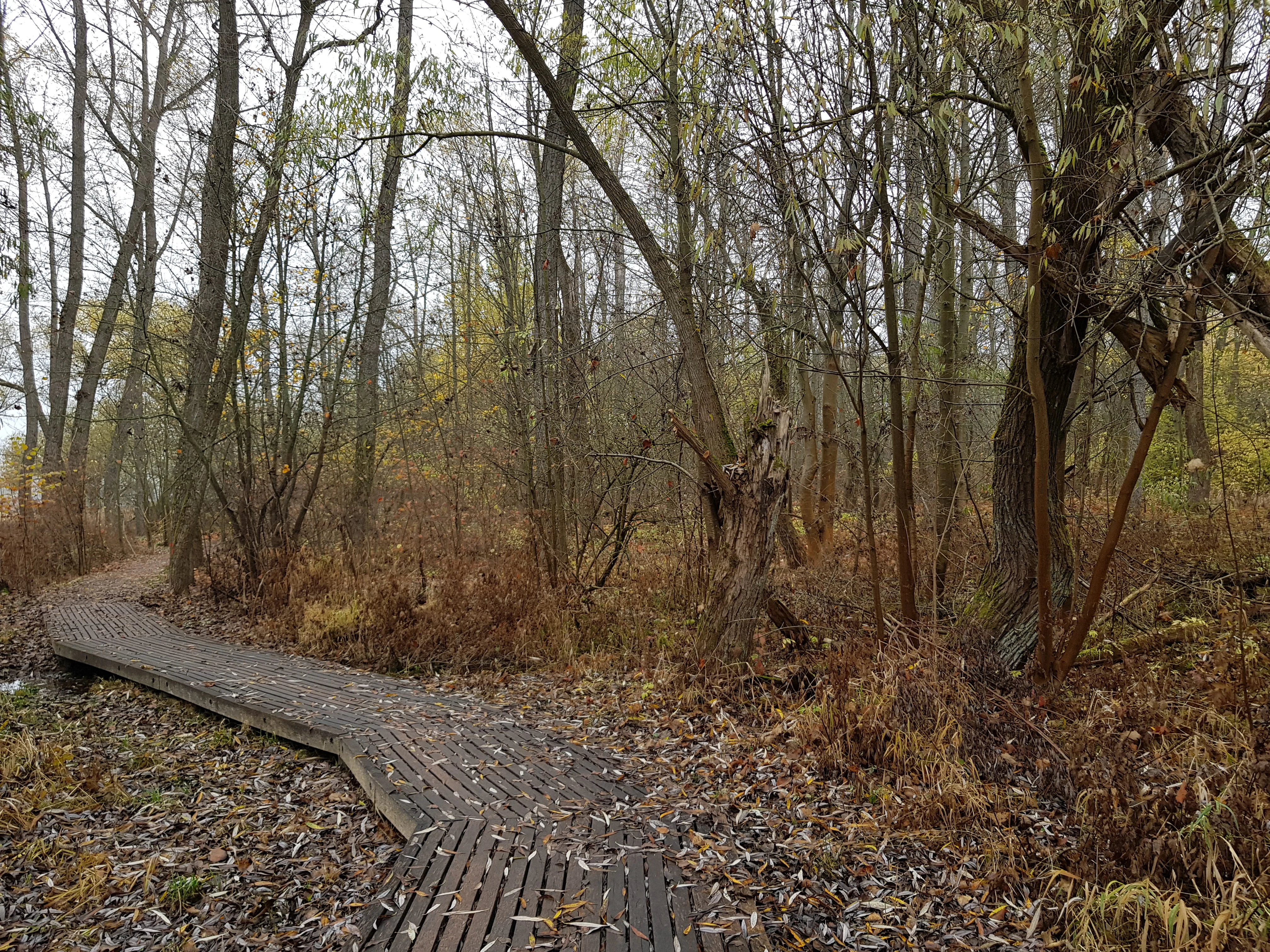
A slatted wooden boardwalk path curves through a deciduous forest with fallen leaves covering the ground under an overcast sky.
A wooden boardwalk winding through the alluvial forest of Vejsplachy Natural Monument in autumn.

Vejsplachy history and protected-area timeline

The vegetation of Vejsplachy was first described by the Czech botanist Ladislav Josef Čelakovský in his Prodromus of the Czech Flora, evidence that the locality was already recognized as botanically interesting in the nineteenth century. Historical management shaped the site in ways that are still visible today: the meadows were traditionally mown for hay, and the repeated passage of farm machinery across the soft ground created shallow tůně, small ephemeral pools that have gradually filled in but remain a recognizable feature of the landscape.

In the years leading up to protection, land use shifted. Hay was no longer taken from the meadows in the usual way, and cut biomass was increasingly left on the site rather than removed, while part of the area saw unofficial dumping of waste. The small floodplain forest meanwhile developed largely on its own through natural succession. These changes prompted local conservation authorities to formalize the site's status.

On 20 February 2020, the Královéhradecký Regional Authority declared Vejsplachy a přírodní památka, a category of natural monument under Czech nature conservation law. The designation was made to safeguard the habitats and the protected and threatened species that occur there, and to ensure the maintenance of viable populations into the future.

Vejsplachy landscape and geographic character

The landscape at Vejsplachy is gentle and flat to very gently sloping toward the pond, with elevation ranging only between about 469 and 476 meters above sea level. It lies in the Hostinská pahorkatina, a minor geomorphological district within the broader Krkonoše foothills, where Paleozoic bedrock is masked by slope sediments and old river deposits of sand and gravel.

The defining visual feature is not elevation but the structure of the ground: a fine-grained mosaic of wet meadow, ash-alder floodplain forest, and water. The Vejsplachy rybník, a small traditional pond, forms the northern edge of the protected area, while shallow, slowly infilling pools scattered through the meadows add further texture. The result reads as a small, self-contained floodplain landscape, almost enclosed within the suburban edge of Vrchlabí, but ecologically reminiscent of much larger river floodplains further upstream.

Vejsplachy ecosystems, habitats, and plant life

Ecologically, Vejsplachy is a textbook example of how a tiny site can pack several distinct wetland habitats into a single protected parcel. The dominant habitat is an ash-alder floodplain forest of the valley-floor type, with ash and alder as characteristic canopy species and a ground layer adapted to periodically wet, nutrient-rich conditions. Beneath the trees, the soil remains saturated for long periods, producing gleys rather than better-drained mineral soils.

Beyond the forest, wet thistle meadows cover roughly a third of the area, interspersed with smaller patches of mesophilic oat meadows on slightly drier ground, and eutrophic reedbeds along the pond shore. These habitats form a gradient from open water through reed and meadow to closed forest, and within just a few hundred meters they expose the visitor to a wide range of botanical communities. The seasonally fluctuating shallow pools increase the variability further, by producing transient, unpredictable microhabitats favored by particular invertebrates.

The flora that depends on this mosaic is significant in Czech conservation terms. May orchid, spring snowflake, bogbean, and snake's head fritillary all occur within the protected site, with two of the bulbous species having been introduced inadvertently from neighboring gardens. The combination of permanently moist meadows, transitional reed zones, and shaded forest edge creates the structural complexity that these species require to persist in a landscape that has otherwise been intensively altered.

Vejsplachy wildlife and species highlights

Fauna at Vejsplachy is closely tied to the wetland and floodplain habitats that dominate the site. The most notable animal is the large blue butterfly, a species of European conservation concern that is highly dependent on wet meadows with the right host plants and humidity conditions. Its presence here is one of the principal reasons the locality received formal protection.

Amphibians are represented by the common toad, which breeds in the still waters of the pond and the smaller pools. Reptiles include the grass snake, which uses both the water margins and the meadow-forest transition zone. Birdlife includes the spotted flycatcher, a species associated with mature open woodland and woodland edges, while the red squirrel inhabits the ash-alder canopy. Together these observations confirm that the small site supports a functioning community of forest, meadow, and wetland species, even though individual populations are necessarily limited by the area's compact size.

Vejsplachy conservation status and protection priorities

Vejsplachy was designated as a přírodní památka in 2020 specifically to maintain the integrity of its habitat mosaic and the threatened species that depend on it. The formal subjects of protection include reedbeds of eutrophic standing waters, mesophilic oat meadows, wet thistle meadows, and the ash-alder floodplain forest that covers about two thirds of the site, together with all specially protected and endangered species recorded there.

The conservation aim is to keep these habitats in a favorable condition and to maintain viable populations of their characteristic species over the long term. This implies continued attention to water regime, to management of the meadows, and to preventing further degradation from waste dumping or abandonment, both of which have affected the locality in the recent past. In a regional context, Vejsplachy represents one of the small but ecologically important surviving floodplain remnants in the Krkonoše foothills and contributes to the broader network of Czech small-scale protected sites that aim to preserve biodiversity outside the larger national parks.

Vejsplachy cultural meaning and human context

The locality is intertwined with the long rural history of the Vrchlabí area, where floodplain soils have been exploited for haymaking for centuries. The shallow pools scattered across the meadow are a direct legacy of that mechanical mowing tradition, an inadvertent product of farm equipment passing over soft ground. At the same time, abandonment of hay harvesting and the use of part of the land as an informal dump illustrate the more recent pressures on traditional floodplain landscapes in populated Czech regions.

Top sights and standout views in Vejsplachy

Vejsplachy stands out for the surprising density of habitats packed into a 3.34 hectare footprint: ash-alder floodplain forest, wet thistle meadows, mesophilic oat meadows, reedbeds, and small ephemeral pools all within a short walk. It supports both rare orchids and a nationally important population of the large blue butterfly. The site is also a remarkable example of small-scale, locally led floodplain conservation right at the edge of the town of Vrchlabí.

Best time to visit Vejsplachy

Late spring and early summer are the most rewarding period at Vejsplachy, when the wet meadows come into flower with May orchids, spring snowflakes, and snake's head fritillaries, and the large blue butterfly is on the wing. Early mornings in this season are particularly favorable for observing both flora and butterfly activity, while autumn visits can still be productive for birdlife and forest character in the ash-alder stand.


Monthly climate preview

Track monthly average temperature spans and precipitation patterns across the coordinate profile

Vejsplachy Climate Normals: Long Term Temperature and Precipitation Rhythm

Historical data records mean monthly temperatures ranging from sub-zero winter lows to warm summer maximums alongside steady daily precipitation rates. Opening the complete twelve-month record reveals deeper monthly fluctuations and detailed normals for the protected landscape.
Annual mean7 °C
-4 °C18 °C
Jan-4°
Feb-2°
Mar
Apr
May12°
Jun16°
Jul18°
Aug18°
Sep13°
Oct
Nov
Dec-2°
Warmest month
July

18.1 °C

Coolest month
January

-3.7 °C

Wettest month
July

3.1 mm/day

Driest month
April

1.4 mm/day

Park location guide

Geography guide, regional context, and park location map for Vejsplachy

Vejsplachy park geography, regions, and map view in Czechia

Understand where Vejsplachy sits in Czechia through a broader geographic reading of the surrounding landscape, nearby location context, and its mapped position within the national park landscape.

How Vejsplachy fits into Czechia

Czech Republic is a landlocked Central European country with a population of approximately 10.9 million people. The nation was established as an independent state on January 1, 1993, following the dissolution of Czechoslovakia. Its capital and largest city is Prague, with other major urban centers including Brno, Ostrava, Plzeň, and Liberec.

Wider geography shaping Vejsplachy in Czechia

The Czech Republic is a landlocked country in Central Europe. It is bordered by Germany to the west, Austria to the south, Poland to the northeast, and Slovakia to the southeast. The landscape is predominantly hilly, with the territory covering 78,871 square kilometers.

Map view of Vejsplachy

Use this park location map to pinpoint Vejsplachy in Czechia, understand its exact geographic position, and read its mapped placement within the surrounding landscape more clearly.

Pigeon | © OpenStreetMap contributors

Location context for Vejsplachy

Královéhradecký kraj

Explore detailed imagery of floodplain forests, wet meadows, and wetland habitats.

Vejsplachy Photos and Landscape Scenery: Visualizing the Protected Foothills

Visual documentation of Vejsplachy reveals the intricate mosaic of ash-alder woodlands, reed-fringed ponds, and wet meadows defining the local protected landscape. Examining these field photographs helps researchers and visitors understand the rare botanical diversity and terrain characteristics thriving within the Krkonoše foothills.

A slatted wooden boardwalk path curves through a deciduous forest with fallen leaves covering the ground under an overcast sky.

Park atlas

Compare regional park geography and adjacent protected areas in the foothills

Exploring Parks Near Vejsplachy and Surrounding Protected Landscapes

Browse other protected areas near Vejsplachy to compare regional wetland habitats and foothill topography. Examining adjacent reserves broadens understanding of local conservation networks across the surrounding valley.
Watercolor painting showing green forests, a valley, and distant mountains under a soft sky
National parkLiberec Region
About 0.7 km away#1 closest

Northeast

Krkonoše National Park: Central European Alpine Protected Area and Map Context

Discover glacial landforms and unique ecosystems in the Giant Mountains.

Krkonoše National Park, situated in the Liberec Region, is a premier example of a protected alpine landscape in Central Europe. This page facilitates exploration of its significant glacial geography, including distinct cirques, rockfields, and valleys, providing vital context for understanding its protected area status. Engage with the mapped terrain and discover the unique ecological features that make this national park a cornerstone of conservation and geographic study within the Czech Republic.

Area
363.52 km²
Established
1963
IUCN
II
Visitors
12.1M annual
A minimalist watercolor illustration depicting rolling, layered mountain ridges in soft shades of green, yellow, and light pink against a white background.
National parkDolnośląskie Voivodeship
About 15 km away#2 closest

North

Karkonoski Park Narodowy: Mapping Protected Granite Peaks and Glacial Terrain in Poland

High-mountain landscapes in the Dolnośląskie Voivodeship

Trace the diverse geography of Karkonoski Park Narodowy, where granite blockfields and glacial cirques define the high-altitude terrain. This protected area represents one of Central Europe's most significant upland ecosystems, showcasing a vertical transition from dense forest to alpine tundra.

Area
59.51 km²
Established
1959
Visitors
2M annual
Relief
Mountain
Watercolor illustration of a mountain range with green hills, pink and yellow sky, and sparse vegetation
National parkPoland
About 15 km away#3 closest

North

Karkonosze National Park: A Premier National Park in Poland's Giant Mountains

Discover alpine terrain and unique glacial landscapes.

Karkonosze National Park is a significant protected area in Poland, renowned for its dramatic alpine topography carved by ancient glaciers. As the highest range in the Polish Sudetes, it features striking U-shaped valleys, U-shaped glacial cirques, and diverse subalpine to alpine ecosystems. This national park provides a rich context for understanding Central European mountain geography and exploring its mapped protected boundaries.

IUCN
II
Relief
Mountain
Scope
Terrestrial
A horizontal watercolor illustration showing rolling green hills, a small pond, and trees under a soft, light sky.
Protected landscapeTrutnov District
About 16 km away#4 closest

East

Přírodní park Hrádeček: Protected Landscape Geography and Mapped Regional Terrain

A forested hill-country protected area in Trutnov District

Přírodní park Hrádeček is a regional protected landscape characterized by a compact cluster of forested summits and traditional Bohemian countryside. Located in the Trutnov District, this area features a distinctive bowl-shaped topography anchored by the ruins of Břecštejn castle, offering a clear example of protected hill-forest and rural mosaic environments within the eastern Giant Mountains foothills.

Established
2000
Relief
Upland
Climate
Temperate
Access
Easy access
A soft watercolor painting of gentle rolling green hills and meadows with patches of trees, set against a background of distant mountains.
Natural monumentKrálovéhradecký kraj
About 17 km away#5 closest

East

Sklenářovické údolí Natural Monument: Geography, Terrain, and Protected Land Features

Meadow-rich valley ecosystems in the Krkonoše foothills

Sklenářovické údolí stands as a significant protected natural monument in the Královéhradecký kraj region. Its geography consists of a deeply carved stream valley that shelters an unusually high concentration of rare orchid species and sensitive wetland habitats. The area provides a clear look at historical land-use restoration, where meadow and forest boundaries are maintained to protect diverse raptor nesting grounds and fragile montane flora within the broader Czech landscape network.

Area
1.806 km²
Established
2009
IUCN
III
Relief
Mountain
A soft watercolor illustration of a rolling natural landscape with green trees, distant hills, and gentle colors on a white background.
Natural monumentLiberec Region
About 26 km away#6 closest

West

Na Vápenici Natural Monument: Geological Mapping and Protected Landscape Analysis

Calcareous outcrops and rare forest microhabitats in the Liberec Region

Na Vápenici represents a focused example of geological diversity, where a distinct limestone outcrop supports unique vegetation and paleontological richness. This natural monument provides a case study for understanding how isolated calcareous substrates contribute to the broader ecological health and terrain character of the Liberec Region.

Area
0.079 km²
Established
2008
IUCN
IV
Relief
Upland
A watercolor illustration of rolling hills with a treeline and meadow, featuring soft green and orange tones on a white background.
Natural monumentKrálovéhradecký kraj
About 26 km away#7 closest

Southwest

Na víně Natural Monument: Protected Opoka Slopes and Botanical Geography in Královéhradecký kraj

Geographic atlas and ecological profile of a protected Czech natural monument

Na víně represents an essential, small-scale protected landscape in the Jičín District of Královéhradecký kraj. This site is defined by its characteristic calcareous opoka hill slopes and its role as a botanical refuge for rare, thermophilous species. By mapping the interaction between the underlying Cretaceous geology and the surviving dry grassland communities, this analysis highlights the importance of localized conservation within the broader Bohemian Cretaceous Basin.

Area
0.055 km²
Established
1990
IUCN
IV
Relief
Upland
Watercolor illustration of sandstone rock towers and coniferous trees in a landscape setting with a light color palette.
Nature reserveKrálovéhradecký kraj
About 28 km away#8 closest

Southwest

Prachovské skály Nature Reserve: Geologic Atlas of Bohemian Sandstone Formations

Mapped sandstone towers and protected forest terrain in Královéhradecký kraj

Prachovské skály consists of a concentrated sandstone massif characterized by towering pinnacles and labyrinthine gorges. This nature reserve serves as a prime example of sedimentary erosion in the Bohemian Paradise region, offering a distinct landscape profile that stands in sharp contrast to the surrounding agricultural plains of the Czech Republic.

Area
2.624 km²
Established
1928
IUCN
IV
Visitors
300K annual

Common questions about visiting, size, designation, and location context for Vejsplachy

Vejsplachy FAQs for park facts, access, geography, and protected area context

Find quick answers about Vejsplachy, including protected-area facts, park geography, trail and visitor context, and how the park fits into its surrounding country and regional landscape.
MoriAtlas Explorer

Continue Your Protected Areas Search Across the Global Atlas

Deepen your exploration by continuing the structured search for national parks and protected areas worldwide. Utilize the comprehensive filtering capabilities to compare different conservation landscapes and refine your understanding of global park geography. Discover more about the distribution and characteristics of protected natural areas.

Global natural geography