Mori Atlas logo
Biosphere reserveViliukų–Karpių miškai

Analyzing the mosaic of broadleaved and wetland forest habitats across the Lithuanian lowland.

Viliukų–Karpių miškai Biosphere Reserve: Mapped Protected Landscapes in Ukmergė District

Viliukų–Karpių miškai represents a significant woodland complex and biosphere reserve located within the Ukmergė District Municipality of Lithuania. This protected territory serves as an essential ecological bridge, defined by a mosaic of broadleaved forest stands and paludified wetland depressions. The area maps a transition between drier mineral soils and moisture-rich swamp woodlands that support rare European-protected species within the Armona river basin.

lowland forestbroadleaved forestwetland forestNatura 2000 sitebiosphere polygonbutterfly conservation

Viliukų–Karpių miškai

Biosphere reserve

Park overview

Structured park overview, official facts, and landscape profile for Viliukų, Karpių miškai

Viliukų, Karpių miškai park facts, protected area profile, and essential visitor context

Review the core facts for Viliukų, Karpių miškai, including designation, size, terrain, visitor scale, habitats, and operating context in one park-focused overview.

About Viliukų, Karpių miškai

Viliukų–Karpių miškai represents an ecologically valuable lowland forest tract in central Lithuania, combining production forestry with the conservation of habitats and species of European significance. Located in the Ukmergė district within the Deltuva eldership, the forest is surrounded by a constellation of small villages, including Viliukai, Jakutiškiai, Bardiškiai, Kačėniškiai, and Pramislava, and its southern edge is bordered by the regional highway Kėdainiai–Šėta–Ukmergė. Together with the adjacent Jakutiškiai forest, the area forms a continuous woodland block of approximately 777 hectares administered by the Ukmergė forestry enterprise under the Viliukai forest range.

The terrain is flat and, in places, waterlogged, lying on gleyed soddy loamy sands and loams that drain into the Armona river basin. Forest stand composition is unusually varied for a lowland Lithuanian site: birch stands dominate at roughly 45 percent, with spruce accounting for about 26 percent, aspens 10 percent, ash stands 7 percent, and smaller shares of black alder, pine, white alder, and oak. This mixture reflects the transition between drier upland soils and the wetter, periodically flooded depressions within the same forest block.

Ecological surveys have revealed a rich and partly unexpected biological heritage. The Viliukų forest was first placed on the Natura 2000 list in 2005 as a site of community importance for habitat conservation, primarily because of two rare butterfly species protected at the European level. Later studies expanded the conservation case, identifying additional rare butterflies, saproxylic insects, vascular plants, orchids, mosses, and even old-growth forest lichens. Two habitat types of European importance have been formally distinguished within the area: broadleaved and mixed forests, and swampy deciduous woodlands. These features place the forest among the more biodiverse woodland sites in Lithuania's Natura 2000 network.

Quick facts and research context for Viliukų, Karpių miškai

Viliukų–Karpių miškai lies in the Ukmergė district of central Lithuania, within the Deltuva eldership, and encompasses roughly 777 hectares of forested land managed by the Ukmergė forestry district. The landscape is flat, partly waterlogged, and underlain by gleyed soddy sandy loam and loamy soils, draining into the Armona basin. The forest was included in the Natura 2000 network in 2005, and a dedicated biosphere polygon was established within it in 2012 to safeguard rare European butterfly populations and characteristic broadleaved and swamp forest habitats.

Protection and recognition

Review the recorded terrestrial management framework and official area status.

Viliukų–Karpių miškai Protection Status and Documented Conservation Scope

Viliukų–Karpių miškai maintains a documented terrestrial protection scope within the regional conservation network. Structured facts outline the recorded designation history and administrative management context without supplementary international frameworks.

Protection details

Protection scope
Terrestrial
Transboundary protection
No
Park context

Deeper park guide and search-rich context for Viliukų, Karpių miškai

Viliukų, Karpių miškai history, landscape, wildlife, and travel context

Explore Viliukų, Karpių miškai through its history, landscape character, ecosystems, wildlife, conservation priorities, cultural context, and seasonal travel timing in a structured park guide built for atlas discovery and search intent.

Why Viliukų, Karpių miškai stands out

The forest is best known for its protected European butterfly populations, especially the scarce fritillary (Hypodryas maturna) and the large copper (Lycaena dispar), which originally earned the site its Natura 2000 designation in 2005. It is equally recognized for its mosaic of broadleaved and wetland forest types that sustain rare woodland plants, lichens, and saproxylic beetles of European conservation concern. Further biodiversity surveys between 2010 and 2011 documented additional protected species, including the woodland brown butterfly (Lopinga achine), the flat bark beetle (Cucujus cinnaberinus), and several rare herbaceous plants and mosses typical of ancient broadleaved forests. These findings reinforced the ecological importance of the area beyond its original butterfly-driven designation.
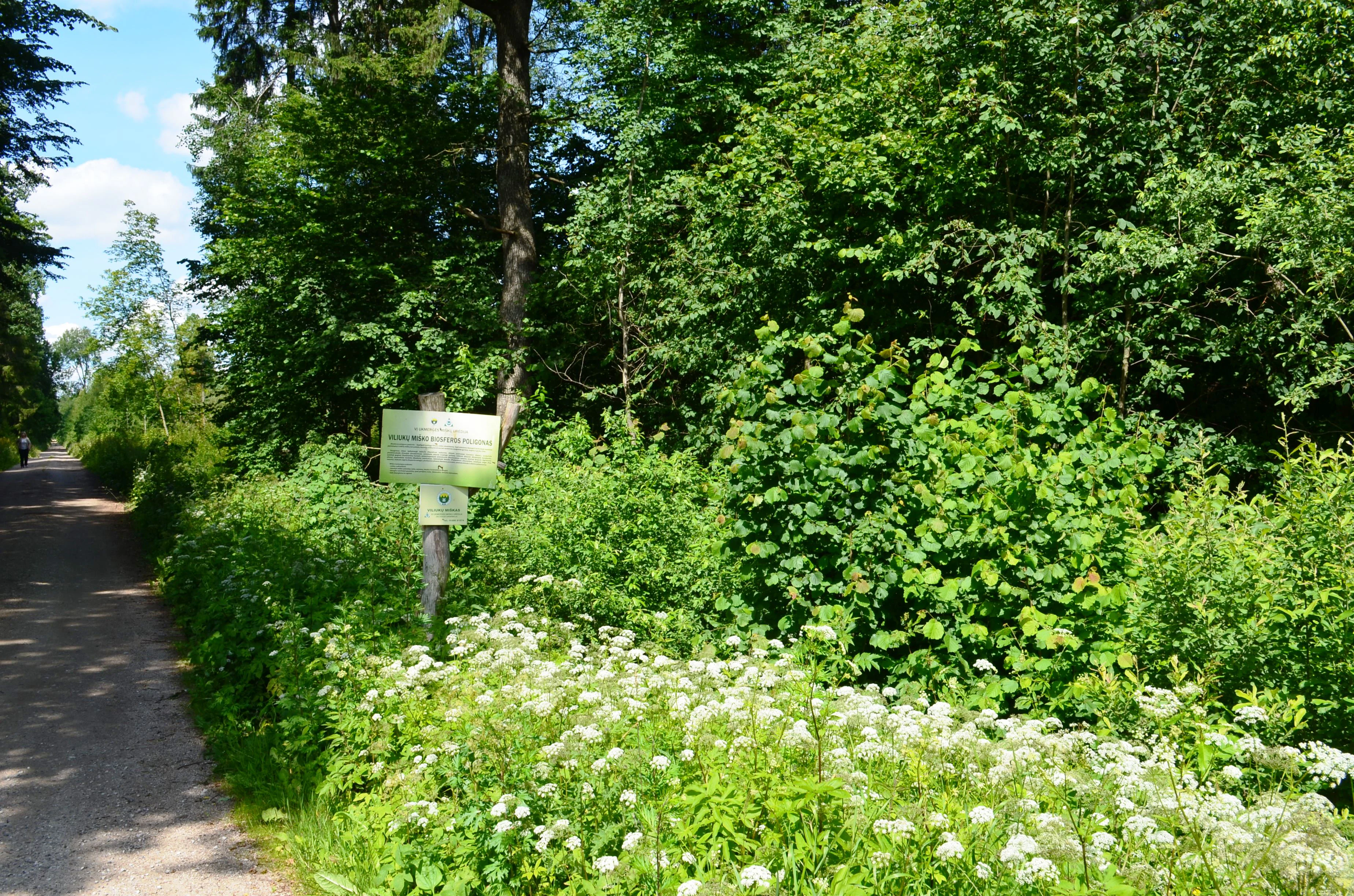
A dirt forest path leads into a dense woodland with a signpost standing near the edge and white wildflowers blooming in the foreground.
A forest trail bordered by lush green vegetation and white wildflowers in Viliukai Forest.

Viliukų, Karpių miškai history and protected-area timeline

The Viliukų forest has a layered history of environmental recognition and formal protection that began in the mid-2000s. In 2005 it was officially registered as a site of community importance within the Natura 2000 network, the European Union's ecological network of protected areas, with its original designation driven by the presence of rare butterfly species of European conservation concern.

Between 2010 and 2011, comprehensive biodiversity surveys were carried out in the forest, uncovering a broader range of protected plants, insects, and lichens than had previously been documented. These findings strengthened the scientific case for stronger long-term protection. In 2012, a formal biosphere polygon, the Viliukų miško biosferos poligonas, was established over part of both the Viliukų and adjacent Jakutiškiai forests to safeguard this ecosystem and its associated species and habitats. Since then, the area has continued to function as an actively managed forest under the Ukmergė forestry district while operating within a structured conservation framework.

Viliukų, Karpių miškai landscape and geographic character

The physical setting of Viliukų–Karpių miškai is a flat, gently undulating lowland typical of central Lithuania. Much of the surface lies low and, in numerous places, has become paludified, producing a mosaic of drier mineral soils and wetter peaty depressions. The underlying substrate consists of gleyed soddy loamy sands and loams, conditions that support both mesic forest types and moisture-dependent swamp woodlands.

Hydrologically, the forest is integrated into the Armona basin, and slow surface drainage in wetter sections contributes to the area's waterlogged character. Despite its low elevation and subdued topography, the interplay of soils, hydrology, and stand composition gives the forest a surprisingly varied micro-landscape, with small-scale transitions between broadleaved upland woodland, spruce-dominated mixed stands, and alder-rich swampy communities. The regional road Kėdainiai–Šėta–Ukmergė runs along the southern edge of the forest and provides a clear southern boundary against the surrounding agricultural countryside.

Viliukų, Karpių miškai ecosystems, habitats, and plant life

Ecologically, the forest is defined by a productive mix of birch, spruce, aspen, and ash stands, complemented by localized black alder, white alder, and oak communities that occupy the wetter and more base-rich patches. Such compositional diversity, unusual for a lowland Lithuanian forest, underpins a correspondingly rich habitat structure covering both broadleaved and mixed forest types and swampy deciduous woodland, both recognized as European Union habitat types of conservation interest.

The site's botanical richness includes nationally and regionally protected plant species typical of ancient broadleaved forests, as well as orchids and bryophytes that are often considered indicators of long ecological continuity. The presence of the lungwort lichen Lobaria pulmonaria, a species strongly associated with old, humid broadleaved woodlands, signals that parts of the forest retain features of high nature value despite ongoing forestry use. Together, these characteristics give the area a dual identity as both a working production forest and a refuge for specialist woodland species.

Viliukų, Karpių miškai wildlife and species highlights

The wildlife of Viliukų–Karpių miškai combines a typical central Lithuanian forest mammal community with a notably specialized invertebrate assemblage. Larger mammals recorded in the forest include red foxes, raccoon dogs, wild boar, moose, roe deer, red deer, pine martens, hares, red squirrels, Eurasian beavers, and muskrats, reflecting the diversity of terrestrial, semi-aquatic, and aquatic habitats within the area.

The forest's most distinctive wildlife value lies in its rare insect fauna, which originally justified its Natura 2000 designation. Two European-protected butterfly species, the scarce fritillary (Hypodryas maturna) and the large copper (Lycaena dispar), are central to the site's conservation profile. Subsequent surveys added the woodland brown (Lopinga achine) and a population of the cinnabar flat bark beetle (Cucujus cinnaberinus), a saproxylic species dependent on decaying broadleaved wood. These invertebrates reinforce the forest's importance as a habitat for species tied to mature, sun-dappled, deciduous-dominated woodland structures.

Viliukų, Karpių miškai conservation status and protection priorities

Viliukų–Karpių miškai is a site of clear European conservation significance, recognized at multiple administrative levels. Since 2005 it has been listed within the Natura 2000 network as a site of community importance for habitat conservation, and in 2012 a portion of the forest was placed under a formal biosphere polygon designation to ensure long-term protection of its ecological values.

Conservation efforts in the forest target the maintenance of rare plant, animal, and fungal species, as well as the preservation of two formally recognized European habitat types: broadleaved and mixed forests, and swampy deciduous woodlands. Surveys have identified protected vascular plants such as Agrimonia pilosa, Dactylorhiza fuchsii, Platanthera chlorantha, Bromopsis benekenii, Gladiolus imbricatus, Huperzia selago, and Poa remota, as well as the moss Neckera pennata and the floating liverwort Ricciocarpos natans. The presence of the old-growth forest indicator lichen Lobaria pulmonaria further underscores the area's value as a reference site for natural broadleaved forest conditions in Lithuania.

Top sights and standout views in Viliukų, Karpių miškai

Viliukų–Karpių miškai stands out as a lowland Lithuanian forest of unusually high ecological value, combining routine forestry production with formal European-level conservation designations. Its inclusion in the Natura 2000 network since 2005, the establishment of a biosphere polygon in 2012, and the documentation of multiple protected butterflies, beetles, plants, and lichens together make it a compact yet biologically dense example of central Lithuania's remaining broadleaved and wetland woodland heritage.

Best time to visit Viliukų, Karpių miškai

As a forest-focused natural area with a mix of dry and waterlogged sections, Viliukų–Karpių miškai is most rewarding to visit during the late spring and summer months, when herbaceous plants, orchids, and butterflies are active and the wetlands are at their most biologically expressive. Autumn can also offer a quieter experience with rich forest colors and a chance to observe deer and other mammals, while winter visits tend to be limited by snow and the absence of easily observable flora and invertebrates.
Monthly climate preview

Long term monthly temperature averages and precipitation patterns measured at Viliuku Karpiu miskai

Viliuku Karpiu miskai Climate Normals, Annual Temperature and Precipitation Rhythm

Representative coordinates record long term monthly temperature extremes and precipitation averages across the protected area. Examining twelve month climate normals reveals complete seasonal variation in temperature and precipitation.
Annual mean6 °C
-5 °C18 °C
Jan-5°
Feb-5°
Mar
Apr
May12°
Jun16°
Jul18°
Aug17°
Sep12°
Oct
Nov
Dec-3°
Warmest month
July

18.1 °C

Coolest month
January

-5.4 °C

Wettest month
July

3.1 mm/day

Driest month
March

1.6 mm/day

Park location guide

Geography guide, regional context, and park location map for Viliukų, Karpių miškai

Viliukų, Karpių miškai park geography, regions, and map view in Lithuania

Understand where Viliukų, Karpių miškai sits in Lithuania through a broader geographic reading of the surrounding landscape, nearby location context, and its mapped position within the national park landscape.

How Viliukų, Karpių miškai fits into Lithuania

Lithuania is a unitary semi-presidential republic and one of three Baltic states in Northern Europe. It lies on the eastern coast of the Baltic Sea, with Vilnius as its capital and largest city. The country regained independence in 1990 after Soviet occupation and joined the European Union in 2004. Lithuania has a population of about 2.9 million and covers an area of 65,300 km².

Wider geography shaping Viliukų, Karpių miškai in Lithuania

Lithuania is situated on the eastern shore of the Baltic Sea in Northern Europe. It borders Latvia to the north, Belarus to the east and south, Poland to the south, and Russia's Kaliningrad Oblast to the southwest. The country also has a maritime border with Sweden to the west. The terrain is largely flat with rolling hills, numerous lakes, and rivers. The Nemunas River is the longest river in the country.

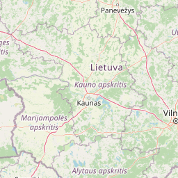
Map view of Viliukų, Karpių miškai

Use this park location map to pinpoint Viliukų, Karpių miškai in Lithuania, understand its exact geographic position, and read its mapped placement within the surrounding landscape more clearly.

Pigeon | © OpenStreetMap contributors

Location context for Viliukų, Karpių miškai

Ukmergė District Municipality

Examine the lowland forest habitats, wetland mosaics, and protected woodland terrain.

Viliukų–Karpių miškai Photos and Landscape Scenery Visual Exploration

Visual documentation captures the flat terrain, broadleaved stands, and waterlogged peat depressions defining Viliukų–Karpių miškai. Examining field photography reveals the complex habitat mosaic sustaining rare European woodland species across the protected area.

A dirt forest path leads into a dense woodland with a signpost standing near the edge and white wildflowers blooming in the foreground.

Park atlas

Discover surrounding lowland forests and regional conservation landscapes

Explore Protected Areas and Parks Near Viliukų–Karpių Miškai

Compare Viliukų–Karpių miškai with other protected natural areas and woodland reserves across central Lithuania. Broader geographic discovery helps place local forest habitats into wider regional context.
Biosphere reserveLithuania
About 25 km away#1 closest

North

Taujėnų, Užulėnio miškų biosferos poligonas: Protected Forest Landscapes of Lithuania

Central Baltic lowland conservation territory

Spanning central Lithuania, this biosphere reserve preserves a vast mosaic of deciduous, coniferous, and mixed forest lands. The territory supports high-quality bird habitats through disciplined forestry practices and the protection of complex wetland and peatland systems, making it a reference site for lowland forest conservation.

Area
44.19 km²
Established
2004
Relief
Lowland
Climate
Temperate
Biosphere reserveAnykščiai District Municipality
About 51 km away#2 closest

Northeast

Šimonių Giria Biosphere Reserve in Anykščiai District Municipality, Lithuania

Protected forest massif and glacial landscape mapping

Šimonių giria stands as a prominent biosphere reserve in northern Lithuania, offering an expansive, pine dominated woodland defined by post glacial sands, extensive peat bogs, and a network of interior lakes. This structured overview details the park geographical features, from its role in the Natura 2000 network to its critical function as a biodiversity monitoring site within the Anykščiai District Municipality.

Area
232.61 km²
Established
2004
Relief
Lowland
Climate
Temperate
Biosphere reserveKauno rajonas
About 52 km away#3 closest

Southwest

Babtų-Varluvos miškų biosferos poligonas: Protected Forest Landscapes and Geographic Mapping

Essential woodland corridors in Kaunas district, Lithuania

Babtų-Varluvos miškų biosferos poligonas functions as a significant biosphere reserve focused on mature lowland forest conservation. This protected area offers a look at continuous woodland structures, research-focused biodiversity monitoring, and the spatial significance of forest corridors within central Lithuanian geography.

Area
44.19 km²
Established
2004
IUCN
VI
Relief
Lowland
Watercolor illustration of a wooden boardwalk path winding through a flat landscape with scattered trees, soft grasses, and muted natural colors.
Nature reserveKauno rajono savivaldybė
About 52 km away#4 closest

Southwest

Dubravos rezervatinė apyrubė: Protected Nature Reserve and Baltic Forest Geography

Central Lithuania protected landscape and wetland mapping

This nature reserve in the Kaunas district protects a rare combination of mature pine forest and open raised bog habitats. By preserving long term undisturbed ecological processes, it provides a stable reference point for forest dynamics in the region. Explore the structural complexity of these coniferous stands and the distinct wetland characteristics of this protected Baltic landscape.

Area
1.2 km²
Established
1994
IUCN
Ia
Relief
Lowland
Watercolor painting showing green hills, trees, a body of water, and grassy vegetation
National parkLithuania
About 67 km away#5 closest

South

Trakai National Historic Park: Medieval Heritage and Lake District Protected Landscape

Explore Lithuania's historic park and its mapped geographic context.

Trakai National Historic Park offers a rich tapestry of medieval history intertwined with a captivating lake district landscape. As a protected area in southeastern Lithuania, it preserves significant architectural monuments, including the iconic Trakai Castle, set against a backdrop of interconnected lakes, forests, and wetlands. MoriAtlas provides a structured overview of its geographic boundaries and regional setting, facilitating atlas-style exploration of this historically significant protected landscape.

IUCN
V
Access
Moderate access
Scope
Mixed
Nature reserveTrakai District Municipality
About 70 km away#6 closest

South

Mergiškių gamtinis rezervatas Protected Nature Reserve in Trakai District Municipality

Strictly protected hornbeam woodland and hilly glacial terrain

Mergiškių gamtinis rezervatas is a protected area in Lithuania dedicated to conserving mature hornbeam-dominated hill forest. Located within the Trakai District Municipality, the reserve provides a critical habitat for threatened species and maintains the natural integrity of hilly glacial landscapes typical of the Aukštadvaris region.

Area
1.57 km²
Established
1996
IUCN
Ia
Relief
Upland
Watercolor painting of a lake surrounded by trees with a sunset sky
National parkLithuania
About 83 km away#7 closest

East

Aukštaitija National Park: Lithuania's Oldest National Park and Protected Landscape Exploration

Mapped geography and lake district atlas for this Baltic region park.

Delve into Aukštaitija National Park, Lithuania's pioneering national park and a key protected area in the Baltic region. This detailed atlas entry highlights its defining geography: an extensive mosaic of over 120 lakes interwoven with ancient pine forests across undulating highlands. Understand the park's protected landscape, its mapped boundaries, and its ecological significance within Eastern Europe's natural terrain.

Area
410.56 km²
Established
1974
IUCN
II
Relief
Upland
Nature reserveŠvenčionys District Municipality
About 84 km away#8 closest

East

Kiauneliškio gamtinis rezervatas: Ancient Forest Landscapes and Protected Terrain Mapping

Nature reserve geography in Švenčionys District Municipality

Kiauneliškio gamtinis rezervatas protects 283 hectares of moist, sandy pine woodland characterized by glacial ridges and historic old-growth specimens. This site acts as an ecological reference for the Labanoro forest landscape, offering clear insights into the undulating lowland topography and rare interior habitats of eastern Lithuania.

Area
2.83 km²
IUCN
Ia
Relief
Lowland
Climate
Temperate

Common questions about visiting, size, designation, and location context for Viliukų, Karpių miškai

Viliukų, Karpių miškai FAQs for park facts, access, geography, and protected area context

Find quick answers about Viliukų, Karpių miškai, including protected-area facts, park geography, trail and visitor context, and how the park fits into its surrounding country and regional landscape.
MoriAtlas Explorer

Continue Your Protected Areas Search Across the Global Atlas

Deepen your exploration by continuing the structured search for national parks and protected areas worldwide. Utilize the comprehensive filtering capabilities to compare different conservation landscapes and refine your understanding of global park geography. Discover more about the distribution and characteristics of protected natural areas.

Global natural geography