Mori Atlas logo
Natural monumentVolcán Tacaná

A transboundary stratovolcano defining the natural border between Mexico and Guatemala

Volcán Tacaná Natural Monument: Exploring the Sierra Madre de Chiapas Volcanic Landscapes

Volcán Tacaná represents a significant geological and protected landscape at the southern end of the Sierra Madre de Chiapas. This active stratovolcano serves as a natural boundary between Mexico and Guatemala, rising to over 4,000 meters. The massif displays a complex geography that transitions from tropical forest and coffee-shaded slopes to rugged alpine terrain, punctuated by persistent volcanic fumaroles and thermal springs.

stratovolcanoactive volcanoMexico-Guatemala borderSierra Madre de Chiapasbiosphere reservetransboundary landscape

Volcán Tacaná

Natural monument

Park overview

Structured park overview, official facts, and landscape profile for Volcán Tacaná

Volcán Tacaná park facts, protected area profile, and essential visitor context

Review the core facts for Volcán Tacaná, including designation, size, terrain, visitor scale, habitats, and operating context in one park-focused overview.

About Volcán Tacaná

Volcán Tacaná sits at the heart of the Sierra Madre de Chiapas, its flanks dropping from more than 4,000 meters of alpine terrain down to the steamy, coffee-growing lowlands of the Pacific slope. The mountain defines the boundary between the municipality of Sibinal in Guatemala's San Marcos department and the Mexican municipalities of Unión Juárez and Cacahoatán in Chiapas, framing the peak as a shared natural and cultural landmark rather than a feature belonging to either country alone.

The volcano is classified as an active stratovolcano of Strombolian character, built from hypersthene and augite andesite that rests on older Tertiary volcanic rocks and granitic-dioritic intrusives. On its west-southwest flank a persistent zone of fumaroles reaches 82 to 94 degrees Celsius, and between 1,500 and 2,100 meters elevation a string of hot springs known as Agua Caliente emerges at gentler temperatures of 40 to 55 degrees Celsius. These features, along with the mountain's height and its occasionally snow-covered summit, mark Tacaná as a fully alive volcanic system rather than a deeply eroded relic.

Around the peak, landscapes shift rapidly. Lower elevations preserve dense, exuberant tropical foliage and the patchwork of subsistence farms and coffee fincas that characterize the Soconusco region. As the route climbs, the forest thins into temperate woodlands scattered with volcanic boulders, before the tree line finally fades near the caldera. The Mexican portion of the massif is protected within a biosphere reserve spanning Cacahoatán, Unión Juárez, and Tapachula, giving Tacaná a meaningful conservation role beyond its tectonic and scenic significance. Together, these characteristics make the volcano a defining landmark of southernmost Mexico and western Guatemala, where geology, climate, and cross-border identity all converge on a single summit.

Quick facts and research context for Volcán Tacaná

Volcán Tacaná is a 4,092-meter active, Strombolian-style stratovolcano on the border between the Mexican state of Chiapas and the Guatemalan department of San Marcos. It is the eighth-highest mountain in Mexico and the second-highest in Guatemala, and it acts as a natural frontier marker in the Sierra Madre de Chiapas. The volcano is composed of hypersthene-augite andesite over a base of Tertiary volcanic and granitic-dioritic rocks, supporting active fumaroles, thermal springs, and a biosphere reserve on its Mexican side.

The name comes from the Mam word for 'house of fire,' reflecting both the mountain's cultural roots and its ongoing volcanic activity. Historical eruptions and fumarolic episodes have been recorded in 1855, 1878, 1903, 1949 to 1951, and 1986, and the peak is now continuously monitored by a broadband seismic network on both sides of the border.

Protection and recognition

Documented terrestrial protection and international UNESCO biosphere recognition

Volcán Tacaná Protection Status and International Recognition Data

Volcán Tacaná features documented terrestrial protection status and verified international recognition as a UNESCO biosphere reserve within a transboundary framework. Structured records compile official designation history and management scope for geographic analysis.

International recognition

Protection details

Protection scope
Terrestrial
Designated year
2006
Transboundary protection
Yes
Core area
44.81 km²
Buffer area
18.97 km²
Park context

Deeper park guide and search-rich context for Volcán Tacaná

Volcán Tacaná history, landscape, wildlife, and travel context

Explore Volcán Tacaná through its history, landscape character, ecosystems, wildlife, conservation priorities, cultural context, and seasonal travel timing in a structured park guide built for atlas discovery and search intent.

Why Volcán Tacaná stands out

Tacaná is best known as the shared volcanic summit that forms the natural border between Mexico and Guatemala, and as one of the tallest, coldest, and most iconic peaks in the region. Its combination of tropical mid-slope agriculture, dense temperate forests, active fumaroles, and thermal springs gives the mountain a layered identity few Central American volcanoes match. In Mexico it is popularly nicknamed 'El Coloso del Sur' for its imposing silhouette above the Soconusco lowlands.
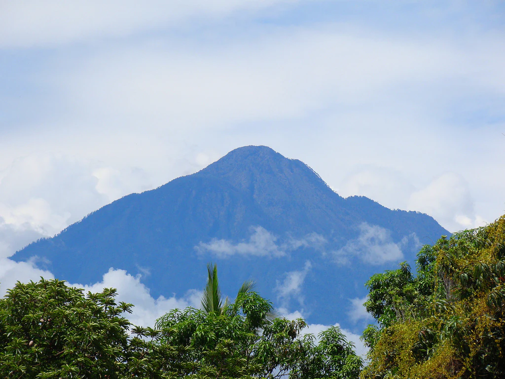
A large stratovolcano peak partially obscured by clouds, framed by green trees in the foreground.
A view of the Volcán Tacaná peak from the Mexican side.

Volcán Tacaná history and protected-area timeline

Scientific attention to Volcán Tacaná stretches back more than two centuries. The earliest known detailed description came from Alexander von Humboldt, who visited the area in 1804. Geologists Del Río (1842), Sánchez (1856), and Del Castillo (1870) followed with additional morphological observations, though it was the German-born researcher Karl Sapper, working in 1896 and 1899, who established the widely accepted naming of the mountain as Tacaná. During the colonial era the volcano was instead referred to as the 'volcán del Soconusco,' reflecting the regional identity of its southern Mexican flank.

The mountain's political and symbolic stature grew during the early twentieth century. In 1905, under Guatemalan President Manuel Estrada Cabrera, engineer and Lieutenant Colonel Francisco Vela incorporated Tacaná into the famous Mapa en Relieve of Guatemala built at the Hipódromo del Norte in Guatemala City, depicting it with detailed contour lines that emphasized its exceptional elevation. The Mexican side of the massif later gained formal protection through a biosphere reserve covering the municipalities of Cacahoatán, Unión Juárez, and Tapachula, anchoring Tacaná within Mexico's network of protected natural areas.

Volcanic activity has been recorded in historical memory across multiple episodes, including phreatic and fumarolic events in 1855, 1878, 1903, 1949 to 1951, and 1986. In January 2010 a light snowfall covered the upper slopes on both sides of the border, reinforcing the mountain's reputation for producing rare winter scenes. Since the early 2010s, broadband digital seismic stations have replaced older short-period instruments, and Tacaná is now continuously monitored by civil-protection authorities and the Universidad de Ciencias y Artes de Chiapas in cooperation with regional partners.

Volcán Tacaná landscape and geographic character

Volcán Tacaná dominates the southern end of the Sierra Madre de Chiapas, its broad cone anchoring the transition between the Pacific coastal plain and the highlands of interior Guatemala. From its 4,092-meter summit the terrain falls steeply through a sequence of ecological zones compressed into unusually short distances: coffee-shaded slopes, dense tropical forests, pine and oak woodlands, and finally open alpine terrain strewn with volcanic rock.

The volcano's geological architecture is andesitic in character, built up over an older basement of Tertiary volcanic strata and granitic to dioritic intrusive rocks. This composition gives the massif its rugged profile and its capacity to support persistent geothermal features. A prominent fumarole field sits on the west-southwest flank, venting steam and gases at temperatures between 82 and 94 degrees Celsius. Below it, the Agua Caliente thermal springs emerge along the 1,500 to 2,100-meter contour, where waters of 40 to 55 degrees Celsius surface along the mountain's mid-elevation band.

From the summit, sweeping views unfold across the Central American Volcanic Arc, including the Guatemalan volcano Tajumulco, while the lowlands of the Soconusco stretch away to the south and southwest. The mountain's elevation, combined with its tropical setting, is unusual enough that snow occasionally dusts its upper flanks, despite the latitude. These layered landscape traits make Tacaná one of the most visually and ecologically dramatic peaks along the Mexico-Guatemala frontier.

Volcán Tacaná ecosystems, habitats, and plant life

The flanks of Tacaná support a compressed ladder of ecosystems that reflect both the mountain's elevation range and its position bridging tropical and temperate climates. Below the volcanic summit, humid tropical woodlands and secondary forests thrive in the moisture-laden air rising from the Pacific slope. These forests grade upward into temperate montane stands rich in mosses, ferns, and broadleaf species typical of the Sierra Madre de Chiapas, eventually thinning into stunted, high-altitude vegetation near the summit cone.

The mountain's varied environments provide important habitat continuity across an international boundary, allowing wildlife communities to extend between the protected zones of both countries. Moisture from frequent cloud cover supports the dense understory and epiphyte load that distinguishes Tacaná's mid-elevation forests. Above the tree line, harsh alpine conditions, exposed rock, and periodic snow cover create a stark but fragile high-country ecosystem. Between these two extremes, the thermal and fumarolic zones add a rare geothermally influenced microhabitat that is biologically distinctive within the region.

Volcán Tacaná wildlife and species highlights

The varied vegetation zones of Tacaná shelter a broad spectrum of Central American wildlife, including species that range from tropical lowland forests up into the temperate cloud forests of the mid-slopes. The mature forests that cling to much of the volcano function as important refuges for native birds, small mammals, and herpetofauna typical of the Sierra Madre de Chiapas. As elevation increases, wildlife communities shift toward species adapted to cooler montane conditions.

The mountain's protected status on the Mexican side, combined with its forested Guatemalan approaches, helps maintain habitat corridors for species that move across the border. While specific census-level detail is limited, the mountain's ecological position within the broader Central American corridor gives its fauna considerable regional importance, especially for resident and migratory bird populations that rely on contiguous forest cover.

Volcán Tacaná conservation status and protection priorities

On the Mexican side of the border, Volcán Tacaná lies within a federal biosphere reserve that covers the municipalities of Cacahoatán, Unión Juárez, and Tapachula. This designation extends formal protection across a substantial portion of the volcano's slopes, safeguarding the area's tropical and montane forests, its geothermal features, and its role as a watershed for communities living below. Tacaná's protected status recognizes both its ecological value and the importance of the mountain as a shared transboundary landscape.

The volcano also carries lasting conservation relevance because of its persistent geothermal activity. Fumaroles on the west-southwest flank and the Agua Caliente thermal springs are preserved as part of the mountain's natural character, while ongoing seismic monitoring by civil-protection agencies and the Universidad de Ciencias y Artes de Chiapas ensures that changes in activity are tracked and assessed. The combination of formal reserve designation, cross-border cooperation, and scientific monitoring frames Tacaná as a conservation asset for the entire region, not just a scenic landmark.

Volcán Tacaná cultural meaning and human context

The name Tacaná comes from the Mam language, one of the Mayan languages spoken in western Guatemala, and translates roughly as 'house of fire,' a fitting description for a volcano that still steams and occasionally erupts. During the colonial era the volcano was known instead as the 'volcán del Soconusco,' after the historical region on the Pacific side of Chiapas. In modern Mexico it is also called 'El Coloso del Sur,' a name that reflects how the summit has come to define the regional identity of southern Chiapas.

Each year during Holy Week, the Confraternidad Montañista del Sureste draws roughly a hundred climbers from Mexico, Guatemala, El Salvador, Honduras, Costa Rica, and invited countries to gather on the summit. Organized by the mountaineering associations linked to Mexico's Instituto Politécnico Nacional and Guatemala's Federación de Andinismo, the gathering turns Tacaná into a recurring site of regional solidarity, where the political border dissolves in favor of a shared mountain tradition.

Top sights and standout views in Volcán Tacaná

Tacaná stands out as a single summit serving two nations: the eighth-highest mountain in Mexico and the second-highest in Guatemala, anchoring the southern end of the Sierra Madre de Chiapas. Its live volcanic character, expressed through persistent fumaroles and the Agua Caliente thermal springs, combines with rare snowfalls to create an unusually layered landscape. The protected Mexican biosphere reserve reinforces the mountain's ecological and watershed importance across the border.

Best time to visit Volcán Tacaná

The most pleasant conditions on Tacaná generally coincide with the dry season, when skies are clearer and the climb is less exposed to the heavy rain and mist typical of the mid-elevation forests. Cooler temperatures at altitude make this period favored for ascents, especially around the Easter-time Confraternidad Montañista del Sureste gathering, which is one of the most established moments in the mountain's climbing calendar. Snow on the upper slopes is rare but possible, particularly in mid-winter, transforming the summit into a striking white landmark visible from the Soconusco lowlands.

Monthly climate preview

Long-term average temperature and precipitation rhythm recorded at a representative point in Chiapas

Volcán Tacaná Climate Normals and Measured Monthly Weather Patterns

Temperature and precipitation data collected at a representative elevation track annual shifts in thermal averages and rainfall accumulation across twelve distinct months. Examining the complete monthly climate normals reveals detailed patterns that define the environmental baseline for Volcán Tacaná.
Annual mean19 °C
17 °C20 °C
Jan17°
Feb18°
Mar19°
Apr20°
May20°
Jun19°
Jul19°
Aug19°
Sep19°
Oct18°
Nov18°
Dec17°
Warmest month
April

20.3 °C

Coolest month
January

16.7 °C

Wettest month
September

12.2 mm/day

Driest month
February

0.2 mm/day

Park location guide

Geography guide, regional context, and park location map for Volcán Tacaná

Volcán Tacaná park geography, regions, and map view in Mexico

Understand where Volcán Tacaná sits in Mexico through a broader geographic reading of the surrounding landscape, nearby location context, and its mapped position within the national park landscape.

How Volcán Tacaná fits into Mexico

Mexico, officially the United Mexican States, is a country in North America spanning the Sierra Madre mountain ranges, coastal plains, and tropical regions. It borders the United States to the north, Guatemala and Belize to the southeast, and has coastlines along the Pacific Ocean, Gulf of Mexico, and Caribbean Sea. With a population exceeding 130 million, Mexico is home to one of the world's most significant concentrations of Indigenous languages alongside Spanish.

Wider geography shaping Volcán Tacaná in Mexico

Mexico occupies a land area of 1,972,550 km2, making it the thirteenth-largest country in the world. The terrain is highly diverse, featuring the Sierra Madre Occidental and Sierra Madre Oriental mountain ranges, the Mexican Plateau, coastal lowlands along the Pacific and Gulf/Caribbean margins, and the Yucatan Peninsula. The country spans multiple climate zones from desert in the north to tropical rainforest in the south.

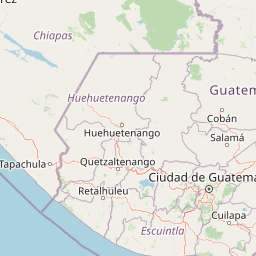
Map view of Volcán Tacaná

Use this park location map to pinpoint Volcán Tacaná in Mexico, understand its exact geographic position, and read its mapped placement within the surrounding landscape more clearly.

Pigeon | © OpenStreetMap contributors

Location context for Volcán Tacaná

ChiapasSan Marcos

Explore protected area views, rugged terrain, and volcanic scenery across the border highlands.

Volcán Tacaná Photos and Landscapes: Visualizing the High Alpine Slopes and Cloud Forests

Visual records capture the dramatic transition from tropical cloud forests to barren volcanic rock across the upper reaches of Volcán Tacaná. Examining national park photography reveals the complex ecological zones and rugged geological architecture defining this transboundary summit.

A large stratovolcano peak partially obscured by clouds, framed by green trees in the foreground.

Park atlas

Compare surrounding volcanic landscapes and transboundary mountain reserves.

Parks Near Volcán Tacaná and Protected Areas of the Sierra Madre de Chiapas

Browsing other parks near Volcán Tacaná reveals the complex volcanic geography and high elevation reserves stretching across the frontier. Expanding the study beyond a single summit provides valuable regional context for protected landscapes in the southern highlands.
National parkChiapas
About 117 km away#1 closest

North

Lagunas de Montebello National Park: Chiapas Protected Landscape Geography & Mapped Boundaries

Explore this national park's unique landscape context within Chiapas.

Lagunas de Montebello National Park offers a detailed view of protected landscape features and regional geographic context within Chiapas, Mexico. As a designated national park, its mapped boundaries are essential for understanding the distribution of protected areas and the natural terrain. This entity provides critical data for exploring the atlas of Mexican natural reserves and their specific environmental settings.

Area
64.11 km²
Established
1959
IUCN
II
Relief
Highland
National parkEscuintla
About 173 km away#2 closest

Southeast

Sipacate-Naranjo National Park: Exploring Its Protected Landscape and Regional Geography

Understand mapped boundaries within Escuintla's natural context.

Delve into the protected landscape of Sipacate-Naranjo National Park, a key national park situated in Guatemala's Escuintla region. This content focuses on its mapped geographic boundaries and its contribution to the regional atlas of protected lands. Gain structured insights into the park's identity and its surrounding natural terrain, crucial for understanding its protected area significance and geographic placement.

Area
20 km²
Established
1969
IUCN
IV
Relief
Lowland
National parkGuatemala
About 176 km away#3 closest

Southeast

Naciones Unidas National Park: Guatemala's National Park Geographic Identity

Explore protected landscape and mapped terrain within Guatemala.

Naciones Unidas National Park represents a key protected area within Guatemala, offering a distinct geographic identity for atlas exploration. This page focuses on its mapped boundaries and its significance as a national park, providing insight into its landscape context and regional setting. Users can delve into its specific geography for structured understanding of protected natural areas.

Area
4.91 km²
Established
1955
IUCN
II
Relief
Mixed relief
Protected areaChiapas
About 203 km away#4 closest

Northwest

Puerto Arista Protected Area: Coastal Geography and Turtle Sanctuary in Chiapas, Mexico

Exploring the Pacific shoreline and mangrove habitat

Puerto Arista is a defined protected area on the Pacific coast of Chiapas, Mexico. The landscape is characterized by thirty-two kilometers of gray volcanic sand beaches, active mangrove estuaries, and essential nesting habitats for multiple sea turtle species. It serves as a focal point for understanding the integration of the Sierra Madre mountain range and the coastal marine environment.

Area
2.125 km²
Established
1986
Visitors
90.4K annual
Relief
Lowland
A minimalist watercolor illustration showing layers of green hills and distant mountain ridgelines against a white background.
Protected areaMexico
About 206 km away#5 closest

Northeast

Bonampak Protected Area: Geography and Landscape Context of the Lacandon Rainforest

An archaeological and natural monument in Chiapas, Mexico

Bonampak encompasses a rich protected area within the Lacandon rainforest, featuring low-lying jungle terrain and significant cultural heritage sites. This atlas entry examines the physical geography, including the site proximity to the Usumacinta River tributaries, and the preservation of continuous tropical canopy that defines the regional biodiversity and cultural landscape.

Relief
Lowland
Climate
Tropical
Scope
Terrestrial
Water
Minor water
Protected areaChiapas
About 219 km away#6 closest

North

Área de protección de flora y fauna Nahá-Metzabok: A Protected Landscape in Chiapas

Mapping tropical rainforests, karst hydrology, and cultural heritage

The Área de protección de flora y fauna Nahá-Metzabok serves as a vital corridor in the Lacandon Jungle, protecting humid rainforests and rare montane cloud forest habitats. Its rugged karst terrain is characterized by prehistoric rock-art caves and critical aquatic systems that sustain regional river basins, offering a layered study of ecological and cultural significance in southern Mexico.

Area
8,617.49 km²
Established
1998
A soft watercolor illustration of a landscape with green trees, pink flowering bushes, and small plants against a pale, distant hilly background.
Wildlife reserveChiapas
About 224 km away#7 closest

Northeast

Área de protección de flora y fauna Chan-Kin: Mapped Wildlife Reserve and Forest Landscape

Exploring protected tropical lowland ecosystems in eastern Chiapas

Área de protección de flora y fauna Chan-Kin represents a critical conservation node within the Selva Lacandona. This protected area maintains a continuous high-canopy forest structure, playing a decisive role in regional biodiversity and the persistence of wide-ranging tropical species across the Usumacinta basin.

Area
121.85 km²
Established
1992
Relief
Lowland
Climate
Tropical
A stylized vector illustration of tiered Mayan pyramid structures rising above a dense green jungle landscape under a soft pastel sky.
Biosphere reservePetén Department
About 225 km away#8 closest

Northeast

Maya Biosphere Reserve: Geographic Overview and Protected Landscapes in Petén

Tropical forest ecosystems and ancient archaeological mapping

Covering roughly one-fifth of Guatemala, the Maya Biosphere Reserve represents a pioneering model of zoned conservation. The landscape features a complex mosaic of lowland rainforests, savanna patches, and seasonal wetlands formed over a weathered limestone platform. This atlas summary examines the reserve's ecological boundaries, its vital role in protecting Mesoamerican biodiversity, and the concentration of pre-Columbian cities located across the Petén Department.

Area
21,602 km²
Established
1990
Relief
Mixed relief
Climate
Tropical

Common questions about visiting, size, designation, and location context for Volcán Tacaná

Volcán Tacaná FAQs for park facts, access, geography, and protected area context

Find quick answers about Volcán Tacaná, including protected-area facts, park geography, trail and visitor context, and how the park fits into its surrounding country and regional landscape.
MoriAtlas Explorer

Continue Your Protected Areas Search Across the Global Atlas

Deepen your exploration by continuing the structured search for national parks and protected areas worldwide. Utilize the comprehensive filtering capabilities to compare different conservation landscapes and refine your understanding of global park geography. Discover more about the distribution and characteristics of protected natural areas.

Global natural geography