Mori Atlas logo
Protected areaÁrea de protección de flora y fauna Nahá-Metzabok

A dense mosaic of rainforests, karst caves, and interconnected lake systems in Chiapas, Mexico

Área de protección de flora y fauna Nahá-Metzabok: Mapping the Lacandon Jungle Protected Landscape

(Área de Protección de Flora y Fauna Nahá-Metzabok)

The Área de protección de flora y fauna Nahá-Metzabok comprises two integrated reserves located within the humid Lacandon Jungle of Chiapas. This protected landscape preserves critical evergreen and cloud forest ecosystems along with an extensive karst geography defined by caves and river networks feeding the Grijalva-Usumacinta basin. These reserves represent a significant stronghold for tropical biodiversity and integrate natural heritage with the enduring presence of Lacandon communities.

Lacandon JungleChiapasTropical rainforestHumid forestCloud forestKarst landscape

Área de protección de flora y fauna Nahá-Metzabok

Protected area

Park overview

Structured park overview, official facts, and landscape profile for Nahá-Metzabok Flora and Fauna Protection Area

Nahá-Metzabok Flora and Fauna Protection Area park facts, protected area profile, and essential visitor context

Review the core facts for Nahá-Metzabok Flora and Fauna Protection Area, including designation, size, terrain, visitor scale, habitats, and operating context in one park-focused overview.

About Nahá-Metzabok Flora and Fauna Protection Area

The Nahá-Metzabok Flora and Fauna Protection Area is one of the most ecologically significant protected landscapes in southern Mexico. It is not a single continuous reserve, but a paired system of two protected polygons, Metzabok and Nahá, that together safeguard more than 7,000 hectares of Lacandon Jungle in eastern Chiapas. Both were decreed on 23 September 1998 under Mexico's federal system of Flora and Fauna Protection Areas, a category focused on preserving ecosystems, biodiversity, and ecological processes rather than supporting intensive resource extraction.

The region sits within the municipality of Ocosingo and is part of the broader Lacandon Jungle, a vast mosaic of humid tropical forest that represents one of the last large rainforest blocks in Mexico. The area's hot, humid climate, with annual average temperatures around 24°C and abundant rainfall, supports exceptionally dense vegetation and a complex aquatic network. Endemic plant communities, evergreen and sub-evergreen canopy forests, and montane cloud forest converge here, creating layered habitats that range from lowland rainforest to higher-elevation moist forest.

Beyond the forest itself, Nahá-Metzabok includes striking karst features. Numerous caves with rock paintings reflect long human presence in the landscape, while natural lakes and rivers connect the area to the larger Grijalva-Usumacinta drainage, one of the most important river systems in Central America and the Caribbean watershed. The Lacanja River, which borders Metzabok, has historically supported local fishing and remains a defining geographic feature of the reserve.

The protected area is also closely tied to indigenous Lacandon communities, descendants of Maya groups who relocated from the Yucatán Peninsula. Their settlement in the area, combined with the natural richness of the rainforest and the region's caves, gives Nahá-Metzabok a layered identity in which ecological preservation and cultural heritage are deeply intertwined. The area is supported for ecotourism, with guided visits to caves such as Tzibana, lake excursions on Laguna Ho Nahá, and access to nearby archaeological sites like Toniná. International recognition came in 2010, when UNESCO added the two reserves to its World Network of Biosphere Reserves, acknowledging both their biodiversity and the role of local communities in maintaining them.

Quick facts and research context for Nahá-Metzabok Flora and Fauna Protection Area

Location: Municipality of Ocosingo, eastern Chiapas, within the Lacandon Jungle. Recognition: UNESCO World Network of Biosphere Reserves since 2010. Designation date: 23 September 1998, for both Metzabok (reference no. 23) and Nahá (reference no. 24). Management category: Mexican Flora and Fauna Protection Area, jointly managed through two separate sub-areas. Climate: warm tropical, with an annual average temperature of approximately 24°C and strong humidity that supports dense rainforest. Key features: tropical humid forests, perennial and sub-perennial high rainforest, montane cloud forest, karst caves, lakes, and the headwaters of the Grijalva-Usumacinta river system. Indigenous communities: descendants of Mayan peoples, including Lacandon communities of Caribbean origin.

Park context

Deeper park guide and search-rich context for Nahá-Metzabok Flora and Fauna Protection Area

Nahá-Metzabok Flora and Fauna Protection Area history, landscape, wildlife, and travel context

Explore Nahá-Metzabok Flora and Fauna Protection Area through its history, landscape character, ecosystems, wildlife, conservation priorities, cultural context, and seasonal travel timing in a structured park guide built for atlas discovery and search intent.

Why Nahá-Metzabok Flora and Fauna Protection Area stands out

Nahá-Metzabok is best known for preserving a large tract of the Lacandon Jungle, one of the most important tropical rainforest remnants in Mexico. The reserves protect extensive stands of high evergreen rainforest, sub-evergreen rainforest, and montane cloud forest, creating a rare mix of humid tropical ecosystems in a single protected unit. The two reserves are also recognized for their karst landscape, which includes numerous caves with prehistoric rock paintings, and for their system of lakes and rivers that feeds into the Grijalva-Usumacinta basin, one of the most important river systems in Mesoamerica. In addition, the area is known for harboring significant wildlife populations, including the jaguar, which depends on the continuity and integrity of these forests. The combination of dense rainforest, caves, lakes, and indigenous Lacandon communities gives the protected area a distinctive identity that blends ecology and cultural heritage.

Nahá-Metzabok Flora and Fauna Protection Area history and protected-area timeline

The territory where Nahá-Metzabok now stands has a long human history that predates its modern protected status. The municipality of Ocosingo, in which both reserves lie, dates back to the Spanish colonial period, when it became a Tseltal town and a base for missionaries such as Fray Pedro de Lorenzo, who left a notable mark on the area's religious architecture. The name Nahá-Metzabok comes from Nahuatl and is generally interpreted as meaning 'Place of the Black Lord,' reflecting the linguistic and cultural layers of the region.

In 1940, the two zones were first set aside primarily as areas for tourism and speleology, attracting interest for their caves and karst formations. At that time, the forests were already inhabited by indigenous communities, including groups now known as the 'Caribbean Lacandones.' These communities are descendants of Maya peoples who migrated to the area from the Yucatán Peninsula after the original Lacandones largely disappeared by 1712.

The modern protected-area history began on 23 September 1998, when the Mexican government decreed both Metzabok (reference no. 23) and Nahá (reference no. 24) as Flora and Fauna Protection Areas. The designation responded to growing concerns about overexploitation of natural resources, including hunting, logging, and unregulated extraction, and reflected the area's importance as one of the last strongholds of humid tropical forest in southern Mexico. The reserves were also created with the explicit purpose of conserving populations of endangered species and the broader forest ecosystem on which they depend.

A significant milestone came on 2 June 2010, when UNESCO incorporated Nahá-Metzabok into its World Network of Biosphere Reserves. Although Mexico classifies the area as a Flora and Fauna Protection Area rather than a formal biosphere reserve, the UNESCO recognition highlighted the conservation value of the forests and the importance of the indigenous communities that inhabit and manage them. Since then, the area has continued to be a center for biodiversity monitoring, ecotourism development, and cultural preservation in the Lacandon region.

Nahá-Metzabok Flora and Fauna Protection Area landscape and geographic character

The landscape of Nahá-Metzabok is defined by the rugged geography of the Lacandon Jungle. Both reserves sit on terrain with elevations ranging from around 700 meters above sea level at Nahá to roughly 840 meters at Metzabok. This relatively modest elevation range, combined with high humidity and warm temperatures, creates conditions favorable for some of Mexico's densest tropical forests. The topography is karstic, with limestone formations shaping much of the underground and surface hydrology.

A defining feature of the landscape is its water system. The region contains natural lakes, including the well-known Laguna Ho Nahá, and is bordered and threaded by rivers such as the Lacanja. These water bodies are not isolated features; they feed into the broader Grijalva-Usumacinta river system, one of the largest and most ecologically important fluvial networks in Mesoamerica. Metzabok in particular is recognized for being an important catchment area, where rainfall collected by lakes and streams ultimately sustains downstream ecosystems and communities far beyond the boundaries of the reserves.

Caves and karst formations are another hallmark of the Nahá-Metzabok landscape. The reserves contain numerous caves, some decorated with prehistoric rock paintings, that give the area both scenic and archaeological value. Among them, the cave of Tzibana stands out as the most significant for its rock art. Together, the forested hills, karst terrain, lakes, and river valleys produce a layered tropical landscape in which natural beauty, hydrology, and ancient human presence are tightly interwoven.

Nahá-Metzabok Flora and Fauna Protection Area ecosystems, habitats, and plant life

Nahá-Metzabok protects a remarkable concentration of humid tropical ecosystems within a relatively compact area. The vegetation includes tropical humid forests, high evergreen rainforest, high sub-evergreen rainforest, and montane cloud forest, each adapted to slightly different elevations and moisture conditions. The result is a vertically and structurally complex forest mosaic, with tall canopy trees, dense understory, and microhabitats that support a wide range of plant and animal species.

According to biodiversity inventories compiled by Mexico's National Commission for the Knowledge and Use of Biodiversity (CONABIO), Metzabok hosts more than 490 species of plants and animals, while Nahá supports more than 1,450 species. Many of these species are endemic or ecologically specialized, and substantial numbers appear in risk categories under Mexico's NOM-059 environmental standard. The presence of exotic or invasive species also reflects the area's ecological complexity and the pressures it faces from outside the reserves.

Botanically, the area is reported to contain roughly 779 plant types across 452 genera and 116 families, with many plants considered at risk of extinction. The combination of evergreen canopy, sub-evergreen formations, and cloud forest communities gives the reserves a layered vegetation structure uncommon outside the most humid regions of Chiapas. Ecologically, Nahá-Metzabok also functions as an important hydrological node, with its lakes and rivers sustaining broader watershed health and biodiversity well beyond the protected boundaries.

Nahá-Metzabok Flora and Fauna Protection Area wildlife and species highlights

The wildlife of Nahá-Metzabok reflects the richness of its forest and lacustrine habitats. The jaguar is the most emblematic species of the reserves and is considered the main endangered animal of the region. Estimates suggest unusually high densities, with reports of close to 119 jaguars per 100 square kilometers, indicating that the area functions as one of the most important strongholds for the species in Mexico.

Beyond the jaguar, the fauna includes other notable mammals and reptiles such as the black panther (melanistic big cat), white turtle, ocotero snake, flying squirrel, raccoon, wild boar, and a range of amphibians including the Nango toad. Birdlife is also significant, and the area has been a focus of monitoring programs for resident and migratory species, including the snowy hawk. The combination of forest, lake, and river habitats supports both terrestrial and aquatic wildlife communities.

The presence of so many species at risk, many classified under Mexico's NOM-059 standard, gives the reserves a particularly high conservation value. Wildlife monitoring has been an ongoing activity in the area, and the continued presence of large predators and sensitive species is widely regarded as a strong indicator of the overall health of the Lacandon Jungle ecosystem.

Nahá-Metzabok Flora and Fauna Protection Area conservation status and protection priorities

Nahá-Metzabok is one of the most important conservation units in southern Mexico. The reserves were established in 1998 specifically to prevent the overexploitation of natural resources in a region facing increasing pressure from logging, hunting, agricultural expansion, and infrastructure development. By classifying the area as a Flora and Fauna Protection Area, the Mexican government set a legal framework that prioritizes the maintenance of ecosystems, biodiversity, and ecological processes over extractive uses.

The conservation significance of the area is significant on multiple scales. Locally, it protects some of the last stands of high evergreen and sub-evergreen rainforest in Chiapas, along with montane cloud forest communities that are particularly vulnerable to climate and land-use change. Regionally, the area's rivers and lakes feed the Grijalva-Usumacinta basin, whose integrity depends on preserving upstream forest cover. Nationally and internationally, the reserves contribute to the conservation of species such as the jaguar, whose long-term survival in Mexico requires connected, well-protected forest blocks.

The UNESCO designation in 2010 elevated the profile of Nahá-Metzabok as a model for combining biodiversity conservation with respect for indigenous presence and traditional land use. Bird monitoring programs, biodiversity inventories by CONABIO, and ongoing ecotourism initiatives reflect an active management approach that seeks to balance ecological protection, scientific research, and the cultural continuity of the Lacandon communities who live in and around the reserves.

Nahá-Metzabok Flora and Fauna Protection Area cultural meaning and human context

The cultural fabric of Nahá-Metzabok is inseparable from its natural landscape. The municipality of Ocosingo, where the reserves are located, has existed since the Spanish colonial era, when it became a Tseltal town and a hub for missionary activity. Missionaries such as Fray Pedro de Lorenzo left a lasting architectural and religious heritage in local churches, anchoring the region within the broader history of colonial Chiapas.

The most distinctive cultural element of the reserves themselves is the presence of the Lacandon communities. The current residents are descendants of Maya peoples who migrated to the area from the Yucatán Peninsula, after the original Lacandon population largely vanished by 1712. They are sometimes referred to as 'Caribbean Lacandones' to distinguish them from earlier historical groups. Their language, customs, and traditional resource management practices remain an essential part of how the Lacandon Jungle is inhabited and understood.

The region's caves and rock paintings, including the cave of Tzibana, add an archaeological layer to this cultural identity, suggesting long and continuous human use of the same forests. Together with nearby archaeological sites such as Toniná, these features frame Nahá-Metzabok as a place where Maya heritage, colonial history, and contemporary indigenous presence all meet within a single protected landscape.

Top sights and standout views in Nahá-Metzabok Flora and Fauna Protection Area

Two integrated reserves, Metzabok and Nahá, jointly managed as a single federal Flora and Fauna Protection Area. Dense and diverse humid tropical ecosystems, including evergreen rainforest, sub-evergreen rainforest, and montane cloud forest. A karst landscape rich in caves, including the rock-art cave of Tzibana and other archaeologically significant sites. Lake and river systems that contribute directly to the Grijalva-Usumacinta basin, one of the most important rivers in Mesoamerica. High biodiversity, with more than 1,450 recorded species at Nahá alone, including many classified at risk under NOM-059. An important stronghold for the jaguar, with unusually high reported population densities. A home to Lacandon communities of Mayan descent, whose cultural heritage is recognized alongside the area's natural value. Recognition by UNESCO as part of the World Network of Biosphere Reserves since 2010.

Best time to visit Nahá-Metzabok Flora and Fauna Protection Area

The climate of Nahá-Metzabok is warm and humid year-round, with an annual average temperature close to 24°C, and rain plays a major role in shaping the experience of the landscape. The dry season generally offers clearer skies, easier access to forest trails, and more comfortable conditions for cave visits and boat trips on Laguna Ho Nahá. Birdwatching and wildlife observation can be rewarding at this time, when animals tend to congregate around water sources.

The rainy season transforms the forests into a particularly lush and immersive environment, with dense vegetation, swelling rivers, and high lake levels. This is also a period when waterfalls, streams, and the karst hydrology are most dynamic, although muddy trails and heavier rainfall can make access more challenging in places. For visitors interested in seeing the rainforest at its greenest, the rains can be an impressive time, but they require more flexibility. Overall, the area is best experienced by visitors who are prepared for tropical humidity and who appreciate the forest regardless of season.

Monthly climate preview

Long-term temperature ranges and monthly precipitation data recorded at a representative elevation coordinate

Área de protección de flora y fauna Nahá-Metzabok Climate Normals and Annual Weather Patterns

Representative baseline measurements capture the long-term annual temperature swings and monthly precipitation rhythms across Área de protección de flora y fauna Nahá-Metzabok. Examining the complete twelve-month climatology profile reveals detailed variations in temperature and precipitation normals for the protected landscape.
Annual mean21 °C
18 °C24 °C
Jan18°
Feb19°
Mar21°
Apr24°
May24°
Jun23°
Jul22°
Aug22°
Sep22°
Oct21°
Nov19°
Dec18°
Warmest month
May

24.2 °C

Coolest month
January

17.9 °C

Wettest month
September

10.4 mm/day

Driest month
March

1.3 mm/day

Park location guide

Geography guide, regional context, and park location map for Nahá-Metzabok Flora and Fauna Protection Area

Nahá-Metzabok Flora and Fauna Protection Area park geography, regions, and map view in Mexico

Understand where Nahá-Metzabok Flora and Fauna Protection Area sits in Mexico through a broader geographic reading of the surrounding landscape, nearby location context, and its mapped position within the national park landscape.

How Nahá-Metzabok Flora and Fauna Protection Area fits into Mexico

Mexico, officially the United Mexican States, is a country in North America spanning the Sierra Madre mountain ranges, coastal plains, and tropical regions. It borders the United States to the north, Guatemala and Belize to the southeast, and has coastlines along the Pacific Ocean, Gulf of Mexico, and Caribbean Sea. With a population exceeding 130 million, Mexico is home to one of the world's most significant concentrations of Indigenous languages alongside Spanish.

Wider geography shaping Nahá-Metzabok Flora and Fauna Protection Area in Mexico

Mexico occupies a land area of 1,972,550 km2, making it the thirteenth-largest country in the world. The terrain is highly diverse, featuring the Sierra Madre Occidental and Sierra Madre Oriental mountain ranges, the Mexican Plateau, coastal lowlands along the Pacific and Gulf/Caribbean margins, and the Yucatan Peninsula. The country spans multiple climate zones from desert in the north to tropical rainforest in the south.

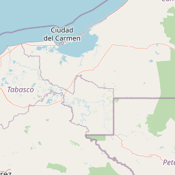
Map view of Nahá-Metzabok Flora and Fauna Protection Area

Use this park location map to pinpoint Nahá-Metzabok Flora and Fauna Protection Area in Mexico, understand its exact geographic position, and read its mapped placement within the surrounding landscape more clearly.

Pigeon | © OpenStreetMap contributors

Location context for Nahá-Metzabok Flora and Fauna Protection Area

Chiapas
Park atlas

Compare regional geography, tropical rainforest habitats, and connected protected landscapes.

Parks Near Área de protección de flora y fauna Nahá-Metzabok and Surrounding Protected Areas

Browse other parks and protected areas near Área de protección de flora y fauna Nahá-Metzabok to examine regional tropical habitats and connected conservation terrain. Comparing adjacent reserves helps place local rainforest ecosystems and karst geography into a broader geographic framework.
A stylized vector illustration of tiered Mayan pyramid structures rising above a dense green jungle landscape under a soft pastel sky.
Biosphere reservePetén Department
About 26 km away#1 closest

Northeast

Maya Biosphere Reserve: Geographic Overview and Protected Landscapes in Petén

Tropical forest ecosystems and ancient archaeological mapping

Covering roughly one-fifth of Guatemala, the Maya Biosphere Reserve represents a pioneering model of zoned conservation. The landscape features a complex mosaic of lowland rainforests, savanna patches, and seasonal wetlands formed over a weathered limestone platform. This atlas summary examines the reserve's ecological boundaries, its vital role in protecting Mesoamerican biodiversity, and the concentration of pre-Columbian cities located across the Petén Department.

Area
21,602 km²
Established
1990
Relief
Mixed relief
Climate
Tropical
A soft, minimalist watercolor painting showing a winding river flowing through rolling green hills against a white background.
Wildlife reserveTabasco
About 45 km away#2 closest

North

Cañón del Usumacinta Wildlife Reserve: Geography and Protected Area Mapping in Tabasco, Mexico

Tropical rainforest, karst cenotes, and riverine canyons

Cañón del Usumacinta represents an ecologically significant protected landscape in southeastern Mexico. This wildlife reserve features high evergreen rainforest, prominent river rapids, and karst geological features such as cenotes and caves. The reserve maintains critical biological continuity through its position in the Mesoamerican Biological Corridor, bridging remote riverine terrain with significant Maya archaeological sites.

Area
461.28 km²
Established
2005
Relief
Mixed relief
Climate
Tropical
A soft watercolor painting of a series of cascading waterfalls surrounded by light green foliage and rolling hills in the background.
Protected areaChiapas
About 59 km away#3 closest

Northwest

Cascadas de Agua Azul: A Geological and Hydrological Survey of the Chiapas Protected Area

Limestone canyons, rainforest biodiversity, and river hydrology

Cascadas de Agua Azul offers a unique perspective on the karst terrain of Chiapas, Mexico. The site features shallow canyons carved by the Otulún and Tulijá rivers, sustained by a humid microclimate that supports dense mountain rainforest. This protected area acts as a crucial link in the regional conservation network, safeguarding limestone-rich soil environments and diverse habitats for migratory and endemic bird species.

Relief
Upland
Climate
Tropical
Access
Moderate access
Scope
Terrestrial
A minimalist watercolor illustration showing layers of green hills and distant mountain ridgelines against a white background.
Protected areaMexico
About 69 km away#4 closest

Southeast

Bonampak Protected Area: Geography and Landscape Context of the Lacandon Rainforest

An archaeological and natural monument in Chiapas, Mexico

Bonampak encompasses a rich protected area within the Lacandon rainforest, featuring low-lying jungle terrain and significant cultural heritage sites. This atlas entry examines the physical geography, including the site proximity to the Usumacinta River tributaries, and the preservation of continuous tropical canopy that defines the regional biodiversity and cultural landscape.

Relief
Lowland
Climate
Tropical
Scope
Terrestrial
Water
Minor water
Natural monumentChiapas
About 69 km away#5 closest

East

Yaxchilan Natural Monument: Geography and Protected Rainforest Boundaries in Chiapas

A mapped overview of river-cradled jungle terrain.

Yaxchilan encompasses a vital protected landscape within the Chiapas rainforest, centered on the dynamic Usumacinta River meander. This park record maps the intersection of tropical forest ecosystems and historical monument sites, offering a grounded look at the physical terrain, river-borne geography, and the natural corridors preserved within this distinct Mexican natural monument.

Relief
Lowland
Climate
Tropical
Access
Moderate access
Scope
Terrestrial
A soft watercolor illustration of a landscape with green trees, pink flowering bushes, and small plants against a pale, distant hilly background.
Wildlife reserveChiapas
About 94 km away#6 closest

Southeast

Área de protección de flora y fauna Chan-Kin: Mapped Wildlife Reserve and Forest Landscape

Exploring protected tropical lowland ecosystems in eastern Chiapas

Área de protección de flora y fauna Chan-Kin represents a critical conservation node within the Selva Lacandona. This protected area maintains a continuous high-canopy forest structure, playing a decisive role in regional biodiversity and the persistence of wide-ranging tropical species across the Usumacinta basin.

Area
121.85 km²
Established
1992
Relief
Lowland
Climate
Tropical
National parkChiapas
About 104 km away#7 closest

South

Lagunas de Montebello National Park: Chiapas Protected Landscape Geography & Mapped Boundaries

Explore this national park's unique landscape context within Chiapas.

Lagunas de Montebello National Park offers a detailed view of protected landscape features and regional geographic context within Chiapas, Mexico. As a designated national park, its mapped boundaries are essential for understanding the distribution of protected areas and the natural terrain. This entity provides critical data for exploring the atlas of Mexican natural reserves and their specific environmental settings.

Area
64.11 km²
Established
1959
IUCN
II
Relief
Highland
National parkPetén
About 164 km away#8 closest

East

El Rosario National Park: Protected National Park & Mapped Landscape Explorer

Geographic context and protected area boundaries within Petén.

Delve into the protected landscape of El Rosario National Park, identified as a national park within Guatemala's Petén region. This page provides an atlas-centric view, highlighting its mapped park boundaries and its significance in the regional geography. Understand the park as a distinct protected area contributing to the natural landscape context, ideal for geographic exploration and detailed mapping.

Area
11.05 km²
Established
1980
IUCN
II
Relief
Lowland

Common questions about visiting, size, designation, and location context for Nahá-Metzabok Flora and Fauna Protection Area

Nahá-Metzabok Flora and Fauna Protection Area FAQs for park facts, access, geography, and protected area context

Find quick answers about Nahá-Metzabok Flora and Fauna Protection Area, including protected-area facts, park geography, trail and visitor context, and how the park fits into its surrounding country and regional landscape.
MoriAtlas Explorer

Continue Your Protected Areas Search Across the Global Atlas

Deepen your exploration by continuing the structured search for national parks and protected areas worldwide. Utilize the comprehensive filtering capabilities to compare different conservation landscapes and refine your understanding of global park geography. Discover more about the distribution and characteristics of protected natural areas.

Global natural geography