
Mori Atlas logo
Nature reserveWätzumer Tonkuhle

Examining the ecological boundaries and post industrial terrain of a key Lower Saxony refuge

Wätzumer Tonkuhle Nature Reserve: Protected Wetland Landscape in the Hildesheim District

(Naturschutzgebiet Wätzumer Tonkuhle)

Wätzumer Tonkuhle serves as a vital island of biodiversity within the intensively cultivated agricultural plains of the Hildesheim District in Lower Saxony. This nature reserve, centered on two relic clay pit ponds and a fallow corridor along the Alpebach, demonstrates the successful restoration of post industrial landscapes into valuable wetland habitats. The site provides a distinct geographic refuge, where natural silt up processes have created a mosaic of shorelines, reed belts, and damp herbaceous banks.

nature reserveclay pitpondswetlandterrestrializationfallow corridor
A flat-style digital illustration showing a lake surrounded by marshy vegetation, trees, and rolling fields with a distant village under a pastel-colored sky.

Wätzumer Tonkuhle

Nature reserve

Park overview

Structured park overview, official facts, and landscape profile for Wätzumer Tonkuhle

Wätzumer Tonkuhle park facts, protected area profile, and essential visitor context

Review the core facts for Wätzumer Tonkuhle, including designation, size, terrain, visitor scale, habitats, and operating context in one park-focused overview.

About Wätzumer Tonkuhle

Wätzumer Tonkuhle is a compact nature reserve that derives its identity from a long-abandoned clay extraction pit. Where once clay was dug for brick or tile making, the open workings have filled with water and formed two ponds. Over time, these ponds have developed natural shorelines with characteristic zones of terrestrialization, where shallow water gradually transitions into reed belts, muddy banks, and damp herbaceous vegetation typical of post-industrial wetland sites in northern Germany.

The reserve covers around 10 hectares in the municipality of Algermissen, located in the Landkreis Hildesheim. Its geographical setting is unusually noteworthy: the reserve lies in the middle of an intensively used agricultural plain southeast of Hannover. In such a landscape, where arable fields and improved pastures dominate, even a small relatively natural patch carries disproportionate ecological importance. Wätzumer Tonkuhle therefore functions as a stepping stone of biodiversity in a region that otherwise offers limited habitat for sensitive species.

A defining feature of the site's spatial structure is its linkage through a fallow strip along the Alpebach. This narrow band of uncultivated ground connects the protected clay pit to another small pond associated with a former brickworks (Ziegelei) at the northern edge of Algermissen. Together, the protected area and its connection corridor form a small but functional network of aquatic and semi-aquatic habitats. Part of the reserve is managed through extensive grazing, which helps maintain open habitats and prevents the encroachment of woody vegetation that would otherwise shade out the wetland flora.

From an administrative standpoint, the reserve was formally designated on 28 August 1986 under the code NSG HA 110. It is recognized internationally as an IUCN Category IV Habitat/Species Management Area and is listed in the World Database on Protected Areas under WDPA ID 166187. Management responsibility lies with the Landkreis Hildesheim as the lower nature protection authority, while strategic oversight is provided by the NLWKN, the Lower Saxony state agency for water management, coastal protection, and nature conservation. Although small, Wätzumer Tonkuhle sits within a broader network of nature reserves across the Landkreis Hildesheim and the region around Hildesheim, and it reflects the long-standing German tradition of protecting even very small, ecologically rich patches of land.

Quick facts and research context for Wätzumer Tonkuhle

Wätzumer Tonkuhle is a protected nature area of roughly 10 hectares, classified as an IUCN Category IV Habitat/Species Management Area. It sits in the Landkreis Hildesheim in Lower Saxony, southeast of Hannover, between the village of Algermissen and its Ortsteil Wätzum. Elevation within the reserve ranges from about 70 to 77 meters above sea level.

The reserve bears the designation NSG HA 110 and is recorded in the World Database on Protected Areas under WDPA ID 166187. Protection was formalized on 28 August 1986, and the area is administered by the Landkreis Hildesheim as the responsible lower nature protection authority, with oversight from the Niedersächsischer Landesbetrieb für Wasserwirtschaft, Küsten- und Naturschutz (NLWKN).

Protection and recognition

Review documented protection status and conservation data records for Wätzumer Tonkuhle.

Wätzumer Tonkuhle Protection Status and Protected Area Designation Details

Examine the verified protection status and recorded administrative identifiers for Wätzumer Tonkuhle within global conservation databases. Access structured designation facts to evaluate the formal safeguarding metrics associated with this protected natural landscape.

Protection details

WDPA ID
166187
Park context

Deeper park guide and search-rich context for Wätzumer Tonkuhle

Wätzumer Tonkuhle history, landscape, wildlife, and travel context

Explore Wätzumer Tonkuhle through its history, landscape character, ecosystems, wildlife, conservation priorities, cultural context, and seasonal travel timing in a structured park guide built for atlas discovery and search intent.

Why Wätzumer Tonkuhle stands out

The reserve is best known for its two relict clay-pit ponds and the naturally forming shoreline transitions around them. These open-water and wetland margins give the site its ecological character and its identity as a refuge for threatened flora and fauna. Equally distinctive is the way the site sits like an island within heavily cultivated farmland. The contrast between the surrounding intensive agricultural landscape and the protected mosaic of ponds, banks, and fallow ground is what gives Wätzumer Tonkuhle its conservation value at the local and regional scales.
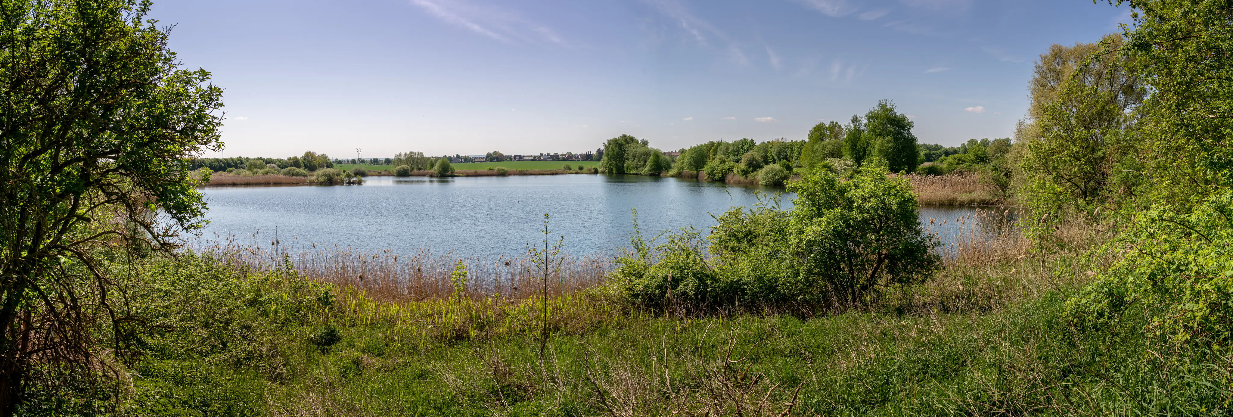
Panoramic view across a calm lake surrounded by lush green trees, shrubs, and reeds under a clear blue sky.
A panoramic view of the ponds and wetland vegetation at Wätzumer Tonkuhle nature reserve.

Wätzumer Tonkuhle history and protected-area timeline

Wätzumer Tonkuhle has its origins in industrial clay extraction. The Tonkuhle, literally a clay pit, was hollowed out to supply clay for local brick and tile production. After the workings were abandoned, the open pit filled with water and gradually evolved into the two ponds and surrounding wetland banks that characterize the site today.

In the second half of the twentieth century, awareness of the ecological value of such post-extraction sites grew in Germany. Increasing pressure on natural habitats from intensive agriculture made even small, secondary refuges ecologically significant. Wätzumer Tonkuhle was officially placed under nature protection on 28 August 1986, becoming one of many small but strategically placed Naturschutzgebiete in Lower Saxony. Since its designation, the site has been managed by the Landkreis Hildesheim with technical oversight from the NLWKN, focusing on maintaining open water bodies, natural shoreline transitions, and extensive grazing to preserve the mosaic of habitats.

Wätzumer Tonkuhle landscape and geographic character

The landscape of Wätzumer Tonkuhle is shaped by the legacy of clay extraction rather than by dramatic natural relief. The site lies on a gently undulating agricultural plain at elevations of roughly 70 to 77 meters above sea level, southeast of Hannover, between Algermissen and Wätzum. Within this flat to very gently rolling terrain, the open pits and ponds form low, relatively shallow basins that contrast with the otherwise uniform surrounding farmland.

The two ponds form the visual and ecological core of the reserve. Their margins have developed distinct zones of terrestrialization: reed belts, muddy shorelines, and damp herbaceous banks. A fallow strip along the Alpebach extends the wetland influence toward a neighboring pond by a former brickworks at the edge of Algermissen, creating a linear green corridor through the cultivated landscape. The result is a small-scale mosaic of open water, wetland edge, semi-open grassland, and light scrub that breaks the monotony of the surrounding fields.

Wätzumer Tonkuhle ecosystems, habitats, and plant life

The nature of the reserve centers on secondary wetland and aquatic habitats colonizing a former industrial site. The two clay-pit ponds and their naturally forming shoreline zones are the principal habitat features, supporting reed communities, muddy banks, and transitional wetland vegetation typical of terrestrializing water bodies in northern Germany.

A fallow strip along the Alpebach extends the wetland character beyond the immediate shore of the ponds, linking the reserve to a further pond associated with a former Ziegelei at the northern edge of Algermissen. Extensive grazing on parts of the reserve maintains open, herb-rich grassland and prevents scrub encroachment, ensuring a continuing mosaic of water, bank, meadow, and lightly vegetated zones. Although small, the site maintains a notably heterogeneous habitat structure for its size and is valued accordingly as a refuge in an otherwise intensively farmed landscape.

Wätzumer Tonkuhle wildlife and species highlights

Wätzumer Tonkuhle serves as a valuable retreat for threatened animal and plant species that struggle to find suitable habitat in the surrounding agricultural landscape. The combination of open water, soft banks, wetland margins, and lightly grazed meadows supports amphibians, aquatic invertebrates, waterbirds, and wetland-edge flora that depend on exactly this kind of secondary wetland mosaic.

The site's role as a refuge rather than a pristine natural habitat is central to its wildlife significance. In a region dominated by plowed fields and improved grassland, the reserve offers cover, breeding space, and feeding opportunities for species that would otherwise be locally absent. Its function as a stepping stone for biodiversity in the Hildesheim district complements the broader network of Naturschutzgebiete in the area.

Wätzumer Tonkuhle conservation status and protection priorities

Wätzumer Tonkuhle is protected as a formal Naturschutzgebiet under Lower Saxon law and additionally classified as an IUCN Category IV Habitat/Species Management Area, reflecting its designation for active management of specific habitats and species rather than for wilderness preservation. Its WDPA entry under ID 166187 places it within the international framework of recognized protected areas.

The conservation significance of the reserve lies in its role as a refuge island in an intensively farmed plain. By safeguarding a former clay-pit wetland complex, a fallow corridor along the Alpebach, and parts of neighboring pond habitat, the site maintains habitat heterogeneity at a regional scale where natural variation has largely been lost. The designation on 28 August 1986, the involvement of the Landkreis Hildesheim as the responsible authority, and the technical oversight of the NLWKN together ensure long-term legal protection and ongoing habitat management, including extensive grazing to keep key habitats open.

Wätzumer Tonkuhle cultural meaning and human context

The cultural context of Wätzumer Tonkuhle is rooted in the rural, agricultural character of the Hildesheim region. The reserve is embedded in a community shaped by farming traditions and by older building materials industries that relied on local clay extraction. Clay pits (Tonkuhlen) and brickyards (Ziegeleien) are a recurring element of the historical industrial landscape of northern Germany, and Wätzumer Tonkuhle represents a preserved example of how such sites can be re-imagined as natural heritage after industrial use ends.

Its location on the boundary between Algermissen and the village of Wätzum ties the reserve to small-scale rural settlement patterns typical of Lower Saxony, where villages, fields, and small wetland patches have long coexisted. The protection of Wätzumer Tonkuhle reflects the modern German tradition of integrating even very small, ecologically meaningful patches into formal conservation frameworks, alongside larger woodlands and river floodplain reserves.

Top sights and standout views in Wätzumer Tonkuhle

Two clay-pit ponds with naturally forming shoreline transitions form the heart of the reserve, offering a compact example of secondary wetland succession in Lower Saxony.

A fallow corridor along the Alpebach links the protected area to a neighboring former brickyard pond, creating a small but functional habitat network. Set amid intensively used farmland southeast of Hannover, Wätzumer Tonkuhle stands out as a refuge island of biodiversity and is a clear illustration of how post-extraction sites can be transformed into valued conservation areas.

Best time to visit Wätzumer Tonkuhle

Wätzumer Tonkuhle is a small, low-relief nature reserve in agricultural countryside, so its character shifts mainly with the seasons rather than with dramatic weather. Spring and early summer typically bring the most active wetland bird and amphibian presence around the ponds and their banks, while the reed fringes and terrestrialization zones are at their most lush.

Late spring and summer also offer the most varied flowering display along the sheltered banks and fallow strip along the Alpebach, as well as the warmest conditions for observing dragonflies and other water-associated invertebrates. Autumn brings quieter, more reflective conditions, with migratory waterfowl potentially using the open water. Winters are generally mild for the region, with bare banks making waterbirds easier to observe; access details should always be checked locally.


Monthly climate preview

Long-term representative measurements detailing monthly temperature ranges and precipitation rhythm

Wätzumer Tonkuhle Climate Normals, Annual Temperature and Precipitation Patterns

Representative coordinate records show measured monthly temperature averages ranging from near freezing to warm summer maximums alongside consistent daily precipitation rates. Examining the full twelve-month profile reveals complete long-term climate normals and detailed meteorological distributions for the protected area.
Annual mean9 °C
0 °C19 °C
Jan
Feb
Mar
Apr
May13°
Jun16°
Jul19°
Aug18°
Sep14°
Oct
Nov
Dec
Warmest month
July

18.5 °C

Coolest month
January

0.4 °C

Wettest month
July

2.5 mm/day

Driest month
April

1.4 mm/day

Park location guide

Geography guide, regional context, and park location map for Wätzumer Tonkuhle

Wätzumer Tonkuhle park geography, regions, and map view in Germany

Understand where Wätzumer Tonkuhle sits in Germany through a broader geographic reading of the surrounding landscape, nearby location context, and its mapped position within the national park landscape.

How Wätzumer Tonkuhle fits into Germany

Germany is a federal republic in Western and Central Europe with a population of over 83 million across sixteen constituent states. It is Europe's largest economy by nominal GDP and a major global exporter and importer. The capital is Berlin, and the country borders Denmark, Poland, Czech Republic, Austria, Switzerland, France, Luxembourg, Belgium, and the Netherlands.

Wider geography shaping Wätzumer Tonkuhle in Germany

Germany is located in Western and Central Europe, spanning 357,022 km². It borders Denmark to the north, Poland and the Czech Republic to the east, Austria and Switzerland to the south, and France, Luxembourg, Belgium, and the Netherlands to the west. The country has coastlines on the Baltic Sea and North Sea to the north, with the Alps located in the southern region.

Map view of Wätzumer Tonkuhle

Use this park location map to pinpoint Wätzumer Tonkuhle in Germany, understand its exact geographic position, and read its mapped placement within the surrounding landscape more clearly.

Pigeon | © OpenStreetMap contributors

Location context for Wätzumer Tonkuhle

Hildesheim DistrictLower Saxony

Visual reference for the ponds, wetland margins, and agricultural refuge terrain

Wätzumer Tonkuhle Landscape Photography and Protected Area Scenery

Visual documentation captures the relict clay-pit ponds, wetland shorelines, and fallow corridors defining the terrain of Wätzumer Tonkuhle. Examining these protected habitats reveals the contrast between the natural refuge and the surrounding agricultural plain in Lower Saxony.

Panoramic view across a calm lake surrounded by lush green trees, shrubs, and reeds under a clear blue sky.

Park atlas

Compare regional conservation areas and adjacent wetland reserves across Lower Saxony

Exploring Parks Near Wätzumer Tonkuhle and Surrounding Protected Landscapes

Browse other parks near Wätzumer Tonkuhle to examine similar wetland reserves and post-industrial conservation sites across the surrounding region. Comparing adjacent protected areas reveals broader geographic patterns in local habitat networks and agricultural plain refuges.
A minimalist watercolor painting featuring soft green, yellow, and purple tones depicting a rolling hill landscape with trees and distant hills.
Nature reserveNiedersachsen
About 9 km away#1 closest

South

Haseder Busch, Giesener Berge, Gallberg, Finkenberg Protected Landscape and Map Data

A diverse hill and floodplain ecosystem in Niedersachsen, Germany.

Trace the ecological boundaries and terrain of this expansive nature reserve. The site features a rare convergence of Triassic sedimentary landscapes, including the northernmost calcareous semi-dry grasslands and beech forests in the region, alongside historic floodplain meadows shaped by the Innerste river.

Area
7.42 km²
Established
2019
A soft watercolor illustration of a river winding through a green floodplain with rolling hills in the background.
Nature reserveRegion Hannover
About 9.6 km away#2 closest

West

Leineaue zwischen Hannover und Ruthe: Protected Floodplain and River Geography

Nature reserve geography and alluvial habitat mapping.

Examine the topographic and hydrological features of the Leineaue zwischen Hannover und Ruthe nature reserve. This atlas entry provides insights into the site's dual-channel river structure, calcareous tufa springs, and fragmented alluvial woodlands that define this significant conservation area near Hannover.

Area
9.678 km²
Established
2007
Relief
Lowland
Scope
Terrestrial
Nature reserveRegion Hannover
About 17 km away#3 closest

West

Sundern Nature Reserve and Floodplain Forest Landscapes of Region Hannover

Historic river meander and alluvial habitat preservation

Sundern represents a critical fragment of the historic Leine river floodplain in the Region Hannover. This nature reserve features a complex mosaic of moist backwaters and dry deciduous woodlands, including old-growth oak-hornbeam stands. The area is defined by its glacial valley setting, where centuries of sediment accumulation have shaped a distinct, slightly elevated landscape mosaic that remains vital for regional conservation.

Area
0.504 km²
Established
1931
IUCN
IV
Relief
Lowland
Nature reserveLower Saxony
About 19 km away#4 closest

Northeast

Wendesser Moor Nature Reserve: Mapped Wetland Geography and Protected Landscape Context in Lower Saxony

Exploring the peatland mosaic and marsh bird habitats of the Peine district

Wendesser Moor is a significant 63-hectare nature reserve in Lower Saxony, defined by its rare concentration of fen habitats, alder carr, and open peat pools. As a core component of a wider landscape protection zone, it provides essential refuge for threatened bird species. The reserve functions as a critical node in the local watershed, illustrating how small-scale protected peatlands maintain biodiversity in agricultural lowlands.

Area
0.632 km²
Established
1973
IUCN
IV
Relief
Lowland
Nature reserveLower Saxony
About 20 km away#5 closest

South

Steinberg bei Wesseln Nature Reserve: A Protected Limestone Slope in Lower Saxony

Geographic focus on calcareous grassland and ridge topography

Explore the geography of Steinberg bei Wesseln, a nature reserve in the Hildesheim district of Lower Saxony. This protected area features a steep, south-facing Muschelkalk ridge that supports a rich mosaic of semi-dry grassland and scrub. Its unique microclimate makes it a significant site for understanding habitat conservation within the broader landscape of the German hill country.

Area
0.16 km²
Established
2007
IUCN
IV
Nature reserveLower Saxony
About 22 km away#6 closest

West

Zigeunerwäldchen Nature Reserve: A Detailed Geographic Atlas of the Haller River Floodplain

Protected riparian forest boundaries in Lower Saxony

Zigeunerwäldchen is a protected nature reserve in Lower Saxony that preserves a vital fragment of the Haller river floodplain. The landscape is defined by willow-dominated alluvial forest, marshy clearings, and thick stands of sedge. By maintaining these natural water-influenced terrains, the reserve provides a rare glimpse into the historical floodplain architecture of the Calenberger Land region.

Area
0.15 km²
Established
1986
Watercolor illustration depicting a landscape with soft green hills, forest edges, and distant purple-hued mountains.
Protected areaRegion Hannover
About 23 km away#7 closest

West

Binnensalzstelle am Kaliwerk Ronnenberg: Mapped Protected Area and Industrial Landscape Context

A rare inland saline ecosystem in Region Hannover

Investigate the Binnensalzstelle am Kaliwerk Ronnenberg, a protected area in Region Hannover defined by its unusual saline conditions. This site presents a concentrated intersection of industrial history and ecological rarity, showcasing how potash mine tailings foster salt-dependent habitats in a inland landscape.

Area
0.017 km²
Established
2004
Relief
Lowland
Climate
Temperate
Nature reserveWolfenbuettel
About 26 km away#8 closest

Southeast

Steinbruch Baddeckenstedt Nature Reserve: Protected Limestone Landscape in the Wolfenbuettel District

A restored former quarry environment with rich fossil deposits

Steinbruch Baddeckenstedt protects a six-hectare area of limestone cliffs and calcareous rubble slopes within the Wolfenbuettel district. This former quarry offers a specialized habitat for rare plants and wildlife, providing a vital example of post-industrial land conservation and geological exposure in central Germany.

Area
0.063 km²
Established
2009
IUCN
IV
Relief
Upland

Common questions about visiting, size, designation, and location context for Wätzumer Tonkuhle

Wätzumer Tonkuhle FAQs for park facts, access, geography, and protected area context

Find quick answers about Wätzumer Tonkuhle, including protected-area facts, park geography, trail and visitor context, and how the park fits into its surrounding country and regional landscape.
MoriAtlas Explorer

Continue Your Protected Areas Search Across the Global Atlas

Deepen your exploration by continuing the structured search for national parks and protected areas worldwide. Utilize the comprehensive filtering capabilities to compare different conservation landscapes and refine your understanding of global park geography. Discover more about the distribution and characteristics of protected natural areas.

Global natural geography