Mori Atlas logo
Regional parkWaharau Regional Park

A vital protected corridor connecting forested mountain ranges to tidal estuarine shores

Waharau Regional Park Protected Area and Coastal Landscape Geography in the Waikato Region

Waharau Regional Park occupies a distinct 170 hectare footprint on the eastern edge of the Hunua Ranges, serving as a critical geographic bridge between dense native forest and the coastal tidal flats of the Firth of Thames. Within the Waikato region, this protected area preserves a rich transition of terrain from high-country valleys to the waters of Waihihi Bay. The land acts as a southern gateway to the broader Hunua forest network, linking inland catchment areas with the Hauraki Gulf shoreline in a continuous protected landscape.

regional parkcoastal parkHunua RangesFirth of Thamesnative forestestuarine habitat

Waharau Regional Park

Regional park

Park overview

Structured park overview, official facts, and landscape profile for Waharau Regional Park

Waharau Regional Park park facts, protected area profile, and essential visitor context

Review the core facts for Waharau Regional Park, including designation, size, terrain, visitor scale, habitats, and operating context in one park-focused overview.

About Waharau Regional Park

Waharau Regional Park occupies a narrow but ecologically and culturally meaningful stretch of land along the southwestern edge of the Hauraki Gulf. It lies four kilometres south of Whakatīwai Regional Park and spans the boundary area between the Auckland Region and the Hauraki District within the Waikato Region. Although it sits outside Auckland's administrative boundaries, the park has been owned and managed by Auckland Council since it was first acquired as public land in the early 1970s.

The defining geographic feature of Waharau is its vertical span, dropping from the eastern foothills of the Hunua Ranges down to the tidal flats and bays of the Firth of Thames. This transition from forested hill country to mudflat and estuarine coast gives the park a strong sense of contrast within a small area. To the west, Waharau adjoins the much larger Hunua Ranges Regional Park, meaning the two reserves together form a connected landscape rather than isolated blocks of protected land.

Originally acquired to secure vehicle access to the eastern water catchment of the Hunua Ranges, the park has since developed into a multi-use regional reserve with camping areas, walking opportunities, and visitor facilities. The presence of an information centre and camping grounds reflects its role as an accessible gateway park for Aucklanders heading into the Hunua Ranges or seeking a coastal escape along the Firth of Thames.

Quick facts and research context for Waharau Regional Park

Waharau Regional Park is a 170 hectare regional park in the Hauraki District and Waikato Region, on the eastern fringe of the Hunua Ranges. It is administered by Auckland Council despite sitting just outside the Auckland Region boundary.

The park extends from the eastern side of the Hunua Ranges down to the Firth of Thames coast, adjoining both Hunua Ranges Regional Park to the west and Whakatīwai Regional Park further north. It was officially opened in 1979 by Te Atairangikaahu, the Māori queen.

Protection and recognition

Explore terrestrial protection metrics and formal designation records for Waharau Regional Park.

Waharau Regional Park Protection Status and Conservation Recognition Data

Waharau Regional Park features documented terrestrial protection status and management records within regional conservation frameworks. Detailed recognition metrics provide structured insight into the environmental designation history and administrative scope.

Protection details

Protection scope
Terrestrial
Transboundary protection
No
Park context

Deeper park guide and search-rich context for Waharau Regional Park

Waharau Regional Park history, landscape, wildlife, and travel context

Explore Waharau Regional Park through its history, landscape character, ecosystems, wildlife, conservation priorities, cultural context, and seasonal travel timing in a structured park guide built for atlas discovery and search intent.

Why Waharau Regional Park stands out

Waharau is best known as the coastal access point to the eastern Hunua Ranges, linking forested hill country with the tidal shores of the Firth of Thames. It is also notable for its layered settlement history, from pre-colonial Māori paper mulberry and karaka groves to 19th century kauri logging. The park's compact footprint, its direct frontage onto Waihihi Bay, and its position at the southern edge of the Auckland regional park network give it a transitional character between mountain forest and estuarine coast.
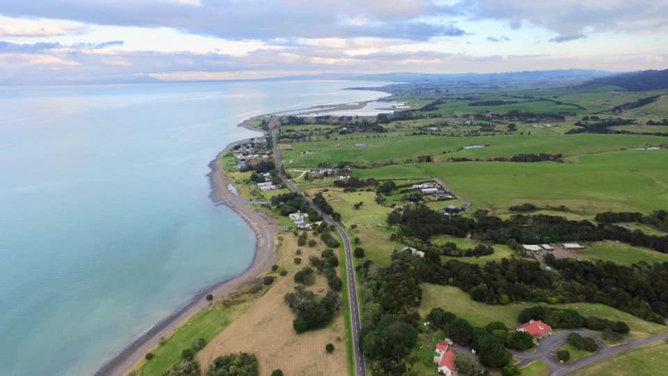
An aerial view of a road running parallel to a coastline with a large body of water on the left, flanked by green fields and scattered trees on the right.
Aerial view of the Firth of Thames coastline near Waharau Regional Park.

Waharau Regional Park history and protected-area timeline

The southern shoreline of what is now Waharau Regional Park, around Waihihi Bay, is part of the traditional landing area of the Tainui migratory waka. In the centuries before European arrival, the area was settled for extended periods and was known for its groves of paper mulberry, known in Māori as aute, and karaka trees, which were valued cultural resources.

From the 17th century onward, the area became associated with the Ngāti Puku hapū of Ngāti Whanaunga, who continue to hold connections to the land. Following European settlement from the 1860s, the eastern Hunua Ranges, including parts of what would later become Waharau, were logged for kauri timber, leaving a historical imprint on the forest composition of the area.

In the early 1970s, the Auckland Regional Authority purchased the land between 1970 and 1973, primarily to secure road access to the eastern water catchment of the Hunua Ranges. After acquisition, the area was formally developed as a regional park and officially opened in 1979 by Te Atairangikaahu, the Māori queen. Management has since passed to Auckland Council, which continues to operate the park alongside its neighbouring regional reserves.

Waharau Regional Park landscape and geographic character

Waharau's landscape is shaped by a sharp transition between forested hill country and tidal coastline over a short distance. On its inland side, the park climbs into the eastern flanks of the Hunua Ranges, where regenerating and logged-over native forest characterises the terrain. The hills roll down toward the coast through a series of valleys and lower slopes that gradually give way to flatter ground near the shoreline.

The coastal edge of the park faces the Firth of Thames, a broad tidal inlet that forms the southwestern arm of the Hauraki Gulf. Waihihi Bay, at the southern margin of the reserve, marks the point where forested slopes meet open tidal flats and estuarine waters. This combination of hilly forest, valley systems, and low-lying coastal margin creates a varied topography within a relatively small reserve.

The connection to the neighbouring Hunua Ranges Regional Park extends the effective landscape beyond Waharau's own boundaries, allowing visitors to move between coastal reserve and larger inland forest without crossing private land. This makes the park both a destination in its own right and a southern entry point to the wider Hunua landscape.

Waharau Regional Park ecosystems, habitats, and plant life

The natural character of Waharau is defined by the meeting of two distinct environments: the regenerating native forest of the Hunua Ranges fringe and the estuarine habitat of the Firth of Thames. The forested portions of the park reflect the broader ecology of the eastern Hunua Ranges, which historically supported tall kauri forest and now contains a mosaic of regenerating native species, older logged remnants, and successional growth.

On the coastal side, the intertidal flats and margins of the Firth of Thames support their own ecological systems, with mudflat, saltmarsh, and shallow-water habitats typical of sheltered Hauraki Gulf inlets. The proximity of forest and estuary within a single reserve gives Waharau a layered habitat structure uncommon for a park of its size.

Because the park functions partly as a buffer to the eastern water catchment of the Hunua Ranges, forest protection and catchment health remain central to its ecological role. The combination of regenerating forest, shoreline vegetation, and protected estuary helps maintain ecological continuity between the hills and the sea.

Waharau Regional Park wildlife and species highlights

Wildlife interest in Waharau is closely tied to the two main habitat zones of the park: the forested hill slopes and the Firth of Thames shoreline. The forested margins of the Hunua Ranges support typical North Island bush birdlife, including species associated with regenerating native forest and larger tracts of older growth nearby.

The coastal and estuarine sections of the park provide habitat for wading shorebirds, seabirds, and other fauna associated with the tidal flats of the Firth of Thames. The sheltered nature of the inlet makes this part of the coast particularly productive for shorebird activity.

Together, the forest and tidal environments create opportunities for visitors to encounter both bush birds and coastal birdlife within a single visit, an unusual combination for a compact regional park.

Waharau Regional Park conservation status and protection priorities

Conservation value at Waharau stems from its role within a larger network of protected land along the eastern Hunua Ranges and the Firth of Thames. By adjoining Hunua Ranges Regional Park and sitting near Whakatīwai Regional Park, Waharau strengthens landscape connectivity between inland native forest reserves and coastal protected areas.

A significant part of the park's conservation purpose lies in protecting the eastern water catchment of the Hunua Ranges, a key source of municipal water for the Auckland region. Forest cover in the park helps stabilise soils, filter runoff, and maintain water quality flowing toward the catchment infrastructure.

The estuarine edge of the park also contributes to habitat protection along the Firth of Thames, where tidal flats and shoreline vegetation play a role in supporting wider Hauraki Gulf ecosystem function.

Waharau Regional Park cultural meaning and human context

Waharau Regional Park holds deep cultural significance linked to both early Māori settlement and later Māori King Movement associations. Waihihi Bay, on the southern edge of the park, is recorded as a landing site of the Tainui migratory waka, one of the great voyaging canoes central to the histories of many Waikato iwi. The park's name itself reflects this heritage, and the area was known in pre-colonial times for its groves of paper mulberry (aute) and karaka, trees of considerable cultural importance.

From the 17th century onward, the area became part of the homeland of the Ngāti Puku hapū of Ngāti Whanaunga, whose connection to the land predates European arrival. The formal opening of the regional park in 1979 by Te Atairangikaahu, the Māori queen, reinforced the ongoing relationship between the site and Māori leadership, recognising the park's importance beyond its recreational function.

European-era history added a second layer of cultural context, particularly through 19th century kauri logging, which reshaped the forest landscape. Together these overlapping histories make Waharau a place where Māori heritage, colonial-era forest exploitation, and modern regional park management intersect.

Top sights and standout views in Waharau Regional Park

Waharau Regional Park is distinguished by its position as the southern coastal gateway to the Hunua Ranges, dropping directly from forested hills to tidal bays on the Firth of Thames. Within a compact 170 hectare footprint, it encompasses both native forest and estuarine shoreline, an unusually varied setting for a regional park.

Its connections to neighbouring reserves, including direct adjacency to Hunua Ranges Regional Park and proximity to Whakatīwai Regional Park, give it a role as part of a broader network of protected coastal and hill country. Combined with its layered cultural history and its 1979 opening by the Māori queen, the park offers a blend of ecological, recreational, and heritage value that sets it apart from purely forest-focused or purely coastal reserves in the Auckland system.

Best time to visit Waharau Regional Park

Waharau's coastal and forested setting means it offers different experiences depending on the season. Summer tends to bring the most active use of the camping areas and the warmest conditions for exploring the shoreline and the lower parts of the park, when the Firth of Thames can be calm and accessible.

Spring and autumn are typically quieter periods, when forest tracks in the Hunua Ranges fringe are more comfortable for walking and birdlife activity is often elevated. Winter brings cooler, wetter conditions that emphasise the forested catchment character of the park and the tidal rhythms of the Firth of Thames, while reducing crowding at the campsite and visitor facilities.

Monthly climate preview

Long-term temperature ranges and monthly precipitation averages for Waharau Regional Park

Waharau Regional Park Climate Normals and Annual Weather Patterns

Waharau Regional Park records measured long-term averages from 1991 to 2020, tracking temperature shifts and monthly precipitation rhythms at a representative coordinate. Examining the full twelve-month profile reveals granular climate patterns across the entire annual cycle.
Annual mean16 °C
11 °C20 °C
Jan20°
Feb20°
Mar19°
Apr17°
May15°
Jun12°
Jul11°
Aug12°
Sep13°
Oct14°
Nov16°
Dec18°
Warmest month
February

20.3 °C

Coolest month
July

11.4 °C

Wettest month
July

3.7 mm/day

Driest month
January

1.8 mm/day

Park location guide

Geography guide, regional context, and park location map for Waharau Regional Park

Waharau Regional Park park geography, regions, and map view in New Zealand

Understand where Waharau Regional Park sits in New Zealand through a broader geographic reading of the surrounding landscape, nearby location context, and its mapped position within the national park landscape.

How Waharau Regional Park fits into New Zealand

New Zealand is an island nation in the southwestern Pacific Ocean comprising two main islands and numerous smaller islands. Located east of Australia across the Tasman Sea, it features varied topography with the Southern Alps running along the South Island and volcanic terrain on the North Island. The country was settled by Maori people between 1280 and 1350, followed by European exploration beginning in 1642, and became a Dominion in 1907 before gaining full independence in 1947.

Wider geography shaping Waharau Regional Park in New Zealand

New Zealand lies in the southwestern Pacific Ocean, east of Australia across the Tasman Sea. The country consists of two main islands, the North Island and South Island, plus over 600 smaller islands. The North Island features volcanic plateaus and hills while the South Island is dominated by the Southern Alps mountain range. The country has a long coastline and is surrounded by the Pacific Ocean.

Map view of Waharau Regional Park

Use this park location map to pinpoint Waharau Regional Park in New Zealand, understand its exact geographic position, and read its mapped placement within the surrounding landscape more clearly.

Pigeon | © OpenStreetMap contributors

Location context for Waharau Regional Park

Hauraki DistrictWaikato Region

Visualizing the protected corridor between the Hunua Ranges and the Firth of Thames

Waharau Regional Park Landscape Photos and Coastal Scenery

Visual documentation captures the sharp transition from regenerating native forest on steep hill country down to open tidal flats along the coast. Examining these detailed views helps researchers and visitors understand the complex terrain and estuarine habitats protected within the regional reserve.

An aerial view of a road running parallel to a coastline with a large body of water on the left, flanked by green fields and scattered trees on the right.

Park atlas

Compare adjacent coastal reserves and forested hill country across the regional network.

Explore Parks Near Waharau Regional Park and Surrounding Protected Landscapes

Browse protected areas near Waharau Regional Park to examine connected forest corridors and estuarine coastlines along the Firth of Thames. Extending your geographic comparison across neighbouring regional reserves reveals the broader conservation layout of the surrounding hill country.
Regional parkAuckland Region
15 km away#1 closest

Northwest

Waitawa Regional Park: Coastal Geography and Recreation Landscapes in Auckland

Mapped terrain along the Tāmaki Strait shoreline

Waitawa Regional Park serves as a notable example of repurposed land within the Auckland Region, featuring an open coastal landscape on the Tāmaki Strait. This protected space, formerly an industrial explosives site, now offers a unique geography of grassy tracks, beach access, and historical remnants. Its layout provides a specialized atlas view of coastal development and public land use for outdoor activity.

Area
1.88 km²
Established
2013
Relief
Upland
Climate
Temperate
A soft, watercolor painting of a coastal landscape featuring green rolling hills, distant pale mountains, and patches of vegetation against a white background.
Nature reserveAuckland Region
About 25 km away#2 closest

North

Rotoroa Island Nature Reserve: Mapping the Geography of this Hauraki Gulf Sanctuary

A vital protected island terrain for native species and reforestation

Rotoroa Island serves as a managed conservation landscape within the Hauraki Gulf, defined by its role as a pest-free sanctuary for threatened bird populations and intensive native forest restoration. The island offers a distinct geography that combines maritime coastal terrain with a rich history of social welfare, preserved through intentional land management and active environmental rehabilitation efforts near the Auckland coast.

Area
0.82 km²
Established
2011
Relief
Lowland
Scope
Terrestrial
Regional parkAuckland Region
28 km away#3 closest

Northwest

Whakanewha Regional Park: Mapping the Protected Landscapes and Wetlands of Waiheke Island

Coastal forest and wetland geography in the Auckland Region

Whakanewha Regional Park serves as a vital protected area on Waiheke Island, known for its mature broadleaf forests and significant freshwater wetlands. The park provides a compact yet varied landscape of stream valleys and coastal ridgelines, representing a key component of the regional geography within the Hauraki Gulf, sheltered from broader environmental pressures.

Area
2.7 km²
Established
2007
Relief
Upland
Climate
Temperate
A horizontal, minimalist watercolor painting showing stylized rolling hills in shades of light green, pale yellow, and soft pink against a white background.
Protected areaWaikato Region
About 33 km away#4 closest

East

Coromandel Forest Park: Geography and Protected Area Overview in Waikato, NZ

Native bushland, valley systems, and conservation geography.

Coromandel Forest Park comprises an expansive system of forested hills and valleys covering the heart of the Coromandel Peninsula. This protected area features dense native ecosystems, ranging from the accessible Kauaeranga Valley to the ecologically significant southern blocks. Use this atlas perspective to understand the terrain, boundaries, and conservation value of this essential Waikato Region landscape.

Area
718.99 km²
Established
1971
Relief
Upland
Climate
Temperate
A flat-style digital illustration showing a winding river through a valley with pine trees, steep rock cliffs, and a waterfall under a soft sun.
Nature reserveAuckland
About 38 km away#5 closest

West

Puhinui Reserve: Protected Nature Reserve and Volcanic Geography in Auckland, New Zealand

Coastal wetlands, maar craters, and working agricultural lands

Explore the physical geography of Puhinui Reserve, a protected nature reserve in South Auckland. This site encompasses rare saltmarsh habitat, active volcanic maar features, and estuarine environments situated on the shores of the Manukau Harbour. Gain insight into the volcanic ash, alluvium, and peat soil structures that define this unique transitional landscape.

Area
1.99 km²
Established
1991
Relief
Lowland
Climate
Temperate
A horizontal watercolor painting of a coastal island landscape with rolling green hills, pale distant mountains, and coastal greenery.
Wildlife reserveAuckland
About 38 km away#6 closest

Northwest

Motuihe Island Wildlife Reserve: Protected Landscapes and Hauraki Gulf Geography

Ecological restoration and coastal island history near Auckland

Motuihe Island represents a significant case study in island conservation, featuring intensive native forest regeneration and successful wildlife reintroduction. The mapped landscape details an elongated island geography defined by coastal beaches, sandstone terrain, and rich archaeological layers, serving as a prominent protected reserve for the Auckland region.

Area
1.79 km²
Relief
Lowland
Climate
Subtropical
Access
Moderate access
A pale, minimalist watercolor painting showing a grassy island or shoreline with a small cluster of trees, set against a quiet body of water and soft, distant rolling hills.
Protected areaAuckland Region
About 57 km away#7 closest

West

Motumānawa / Pollen Island: Protected Marine Reserve and Scientific Landscape in Auckland

A coastal shellbank island refuge within the Waitematā Harbour.

Motumānawa / Pollen Island is an essential protected area near the Rosebank Peninsula, serving as a sanctuary for native bird populations and estuarine vegetation. Its status as both a scientific and marine reserve highlights the importance of small-scale coastal conservation within a major metropolitan harbour landscape in New Zealand.

Established
2006
Relief
Lowland
Scope
Marine
Water
Water-dominated
Regional parkAuckland Region
About 67 km away#8 closest

West

Waitākere Ranges Regional Park: Geographic Mapping of Auckland's Protected Coastal Forest

Volcanic terrain and expansive coastal wilderness boundaries

Examine the rugged geography of the Waitākere Ranges, spanning from sheer western sea cliffs to lush, regenerating forest valleys. This overview details the protected land, including volcanic rock formations, black sand surf beaches, and the inland reservoirs serving the Auckland region, highlighting its status as an ecologically critical heritage area.

Area
277.2 km²
Established
1895
Relief
Mountain
Climate
Subtropical

Common questions about visiting, size, designation, and location context for Waharau Regional Park

Waharau Regional Park FAQs for park facts, access, geography, and protected area context

Find quick answers about Waharau Regional Park, including protected-area facts, park geography, trail and visitor context, and how the park fits into its surrounding country and regional landscape.
MoriAtlas Explorer

Continue Your Protected Areas Search Across the Global Atlas

Deepen your exploration by continuing the structured search for national parks and protected areas worldwide. Utilize the comprehensive filtering capabilities to compare different conservation landscapes and refine your understanding of global park geography. Discover more about the distribution and characteristics of protected natural areas.

Global natural geography