
Mori Atlas logo
Nature reserveWasserwerk Johannisthal

A historic urban protected area managing vital groundwater resources within the Treptow-Köpenick district.

Wasserwerk Johannisthal Nature Reserve in Berlin: Mapped Boundaries and Hydrological Landscape Context

(Naturschutzgebiet Wasserwerk Johannisthal)

Wasserwerk Johannisthal stands as a specialized nature reserve in southeast Berlin, encompassing thirty-five hectares of protected land defined by its transition from twentieth-century waterworks infrastructure to a modern environmental management zone. This mapped area sits within a complex urban terrain framed by transport corridors and allotment gardens, functioning today as a critical site for groundwater remediation and hydrological stability. Discover how this industrial-era heritage site continues to shape the regional geography of the capital through its layered subsurface environment and ongoing conservation efforts.

urban nature reserveBerlin nature reservegroundwater protectionformer waterworksindustrial heritage siteprotected habitat
Vector-style illustration of a natural scene with tall grasses in the foreground, a purple flowering bush in the middle, and a forest with mountain peaks in the background under a pale sky.

Wasserwerk Johannisthal

Nature reserve

Park overview

Structured park overview, official facts, and landscape profile for Wasserwerk Johannisthal

Wasserwerk Johannisthal park facts, protected area profile, and essential visitor context

Review the core facts for Wasserwerk Johannisthal, including designation, size, terrain, visitor scale, habitats, and operating context in one park-focused overview.

About Wasserwerk Johannisthal

Wasserwerk Johannisthal is a compact but distinctive protected landscape in the southeastern part of Berlin. Although the city is rarely associated with wilderness, this 35-hectare reserve shows how urban infrastructure corridors can give rise to small but ecologically meaningful protected areas. Its boundaries follow a clear set of urban edges: the Königsheideweg to the north, the Lindental allotment garden complex to the west, the Bundesautobahn 113 to the south, and the Springbornstraße and Koschatweg to the east, anchoring the reserve within a recognisable urban framework.

At its core is a former waterworks that once stood at the heart of Berlin's drinking water supply. Built in 1901 to keep pace with rapid population growth, the original facility relied on two lift lines and 26 pumping wells tapping four major watercourses, the Spree, the Dahme, the Britzer Verbindungskanal, and the Teltowkanal. The site continued to grow over the following decades, and by the 1970s an additional roughly 80 wells brought its daily extraction capacity to around 65,000 cubic metres, enough to serve hundreds of thousands of residents.

The character of the reserve changed fundamentally after 1990, when plunging post-reunification water consumption made such large-scale extraction unnecessary. Active pumping ceased in 2001, and the formal designation of the site as a nature reserve in 2007 cemented its new role. Today, the Wasserwerk Johannisthal functions primarily as a managed groundwater and remediation area, where the surrounding city still influences the environmental priorities of the protected zone.

Quick facts and research context for Wasserwerk Johannisthal

Wasserwerk Johannisthal is a nature reserve (Naturschutzgebiet) located in the Treptow-Köpenick borough of Berlin, Germany. It occupies approximately 35 hectares and lies near the Königsheideweg, with the Bundesautobahn 113 running along its southern edge.

The reserve was formally established on 12 September 2007 and is classified under IUCN Category IV as a Habitat/Species Management Area. Its World Database on Protected Areas entry is recorded under WDPA-ID 389992, reflecting its recognition within international protected-area databases.

Protection and recognition

Documented terrestrial protection scope and verified international recognition sources

Wasserwerk Johannisthal Protection Status and Designated Conservation Records

Wasserwerk Johannisthal maintains a recorded terrestrial protection status within official international databases. Structured records compile the verified designation scope and documented administrative frameworks associated with this protected area.

Protection details

Protection scope
Terrestrial
WDPA ID
389992
Park context

Deeper park guide and search-rich context for Wasserwerk Johannisthal

Wasserwerk Johannisthal history, landscape, wildlife, and travel context

Explore Wasserwerk Johannisthal through its history, landscape character, ecosystems, wildlife, conservation priorities, cultural context, and seasonal travel timing in a structured park guide built for atlas discovery and search intent.

Why Wasserwerk Johannisthal stands out

The site is best known as a piece of inner-city industrial heritage that has been repurposed into a protected natural area. Once a vital contributor to Berlin's drinking water supply, it now stands as an example of how former waterworks infrastructure can be secured for ecological and hydrological management. It is also notable as a contemporary groundwater protection zone, where legacy contamination issues, particularly arsenic, cyanide, and chlorinated hydrocarbon compounds from surrounding brownfield sites, continue to shape its environmental role.
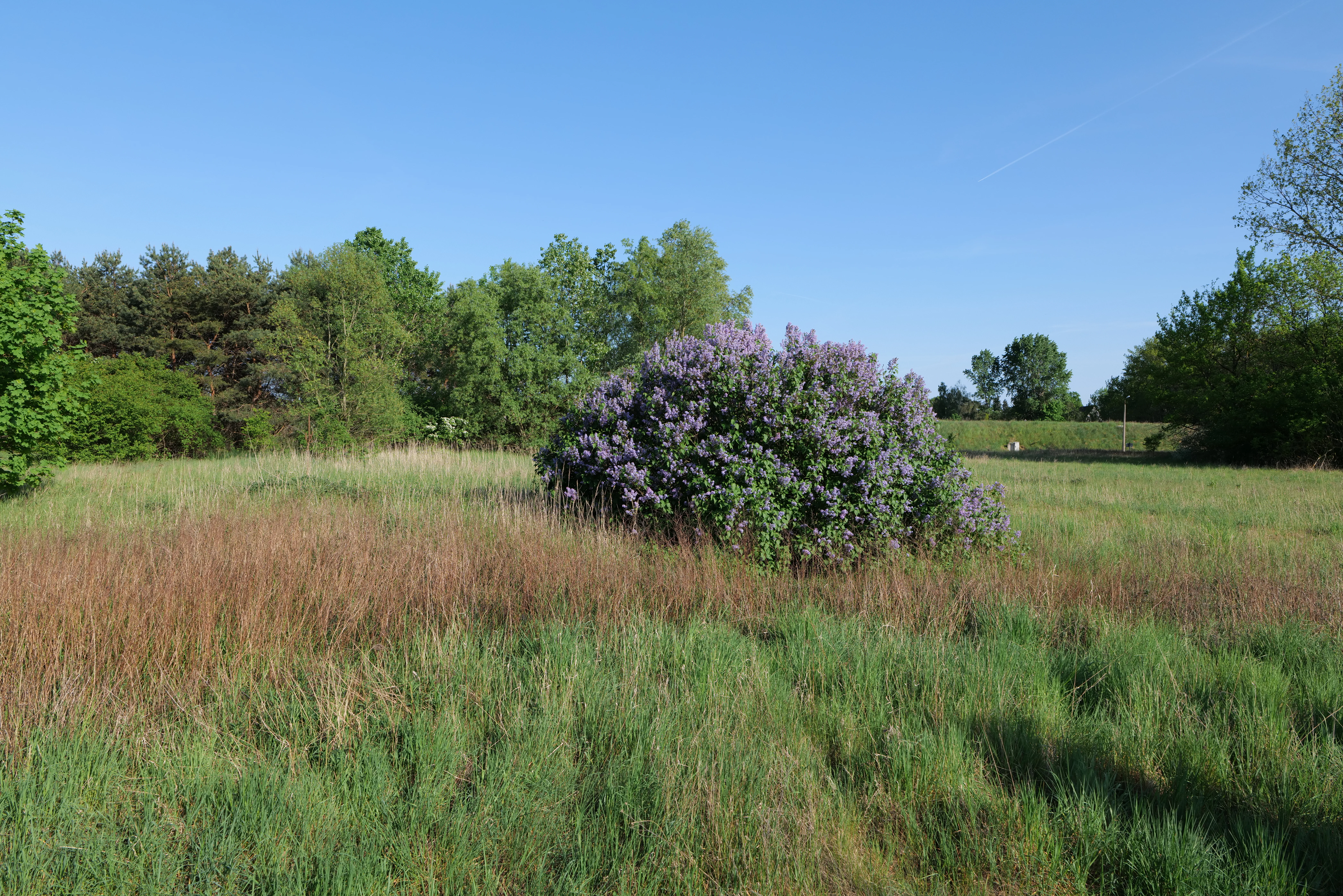
A wide outdoor shot of a grassy meadow with a large purple lilac bush in full bloom sitting in the center, with a backdrop of green trees under a clear blue sky.
A meadow in the Wasserwerk Johannisthal nature reserve featuring a blooming lilac bush.

Wasserwerk Johannisthal history and protected-area timeline

The history of Wasserwerk Johannisthal begins in 1901, when rapid population growth across the expanding Berlin region made a new municipal water supply essential. The waterworks opened with two lift lines and a total of 26 pumping wells drawing on the Spree, the Dahme, the Britzer Verbindungskanal, and the Teltowkanal, establishing the site as a critical piece of the city's hydraulic infrastructure.

Over the early and mid-twentieth century, the facility expanded steadily. By the 1970s some 80 additional wells had been brought online, raising the daily yield to roughly 65,000 cubic metres. At its operational peak the waterworks was able to supply around 300,000 residents with drinking water, making Johannisthal a quietly indispensable element of Berlin's life.

The political and economic transformations following reunification brought a steep decline in water consumption. As demand collapsed, the site ceased active extraction in 2001. Although Berlin's broader water supply planning still identifies Johannisthal as a future drinking water site, comprehensive remediation of surrounding brownfields is required before pumping can resume. The site's current environmental role, overseeing contaminant clean-up and managing urban-compatible groundwater levels, took shape during the following decade and culminated in 2007 with the formal designation of the area as a nature reserve.

Wasserwerk Johannisthal landscape and geographic character

The landscape of Wasserwerk Johannisthal is a contained, heavily urban-adjacent terrain shaped as much by surrounding roadways and allotment gardens as by its internal topography. The roughly 35-hectare area forms a clearly bounded block in southeast Berlin, framed by the Königsheideweg to the north and the busy Bundesautobahn 113 corridor to the south.

West of the reserve lies the Lindental allotment garden complex, while its eastern edge is defined by the Springbornstraße and Koschatweg. Together these features give the reserve a distinctly patchwork appearance, sitting at the meeting point between forested recreational land, small-scale urban horticulture, and major transport infrastructure.

Beneath this surface setting, the more important landscape story is hydrological. The site is threaded through with groundwater influenced by four major waterways, the Spree, the Dahme, the Britzer Verbindungskanal, and the Teltowkanal. More than a century of pumping has left a layered subsurface environment that continues to define the reserve's management, even where the visible surface itself is comparatively modest.

Wasserwerk Johannisthal ecosystems, habitats, and plant life

Wasserwerk Johannisthal is classified under the IUCN framework as a Habitat/Species Management Area (Category IV), underscoring that its ecological value is bound up with active habitat stewardship rather than purely passive protection. The area sits within one of Berlin's most heavily managed urban-natural transitions, where allotment gardens, forested corridors, and transport routes meet.

Although the reserve's size is modest by national-park standards, it contributes meaningfully to a network of protected areas in southeast Berlin that includes nearby features such as the Königsheide forest, allotment complexes, and other small water-related reserves. Its presence helps preserve habitat continuity in a borough where green spaces are dissected by roads and waterways.

Groundwater dynamics are central to the reserve's ecological identity. Because the aquifer beneath the site has historically been influenced by both municipal extraction and surrounding contamination, the area is managed with an unusual emphasis on hydrological stability, a feature that distinguishes Wasserwerk Johannisthal from purely terrestrial Berlin nature reserves.

Wasserwerk Johannisthal wildlife and species highlights

The available source material does not provide detailed accounts of individual species or species groups within the reserve. Because the area is described primarily through its infrastructure history and current groundwater-management role, specific wildlife content cannot be reliably constructed from the given sources.

Wasserwerk Johannisthal conservation status and protection priorities

Wasserwerk Johannisthal functions as both a legally protected nature reserve under German Naturschutzgebiet law and a strategically managed groundwater protection zone. Its conservation significance lies in the combination of ecological protection and the safeguarding of subsurface water resources in a heavily urbanised setting.

A key concern is contamination. Contaminants such as arsenic, cyanide, and chlorinated hydrocarbons (LCKW) have entered the groundwater from surrounding brownfield sites, requiring ongoing remediation. As a result, conservation here is closely tied to long-term environmental clean-up, with the reserve's protected status providing a stable legal and planning framework for these efforts.

The reserve's inclusion in Berlin's broader water supply planning, alongside its formal designation in 2007 and its registration in the World Database on Protected Areas under WDPA-ID 389992, reinforces its importance as a long-term, multi-purpose protected site. It illustrates how urban reserves can simultaneously serve biodiversity, public health, and water-security goals.

Wasserwerk Johannisthal cultural meaning and human context

The cultural context of Wasserwerk Johannisthal is rooted in the industrial and infrastructural history of modern Berlin. Its establishment in 1901 reflected the capital's rapid expansion in the early twentieth century, when the city required newly engineered water systems to serve its growing population.

The site's continued role in Berlin's water planning documents, even after active extraction ceased, shows how infrastructure of this era remains part of the city's strategic thinking about drinking water supply. The conversion of an active waterworks into a nature reserve also reflects a broader post-reunification shift in Berlin, where former industrial and infrastructural sites have been reimagined as ecological and recreational spaces.

Top sights and standout views in Wasserwerk Johannisthal

Wasserwerk Johannisthal stands out for the way it merges three layers of identity: early-twentieth century hydraulic engineering, post-reunification urban-ecological transition, and contemporary groundwater protection. The reserve's compact size belies its structural importance within Treptow-Köpenick's network of green and protected spaces.

A particularly noteworthy feature is its ongoing environmental management role. Despite no longer pumping drinking water, the reserve remains central to Berlin's plans for future water supply and is actively involved in the monitoring and remediation of contaminated groundwater, an unusual combination of responsibilities within a single protected area.

Best time to visit Wasserwerk Johannisthal

The source material does not provide sufficient seasonal information to support detailed or visit-oriented timing guidance. Any claims about peak visiting seasons or seasonal accessibility cannot be reliably drawn from the available sources.

Monthly climate preview

Trace long-term representative temperature ranges and monthly precipitation patterns.

Wasserwerk Johannisthal Climate Normals and Annual Temperature Rhythm

Long-term representative coordinate records for Wasserwerk Johannisthal trace a measured annual temperature span alongside consistent monthly precipitation rates. Detailed monthly climate normals expand this baseline data into a complete twelve-month profile.
Annual mean9 °C
-1 °C20 °C
Jan-1°
Feb
Mar
Apr
May14°
Jun18°
Jul20°
Aug20°
Sep15°
Oct
Nov
Dec
Warmest month
July

20.3 °C

Coolest month
January

-0.9 °C

Wettest month
July

2.4 mm/day

Driest month
April

1.1 mm/day

Park location guide

Geography guide, regional context, and park location map for Wasserwerk Johannisthal

Wasserwerk Johannisthal park geography, regions, and map view in Germany

Understand where Wasserwerk Johannisthal sits in Germany through a broader geographic reading of the surrounding landscape, nearby location context, and its mapped position within the national park landscape.

How Wasserwerk Johannisthal fits into Germany

Germany is a federal republic in Western and Central Europe with a population of over 83 million across sixteen constituent states. It is Europe's largest economy by nominal GDP and a major global exporter and importer. The capital is Berlin, and the country borders Denmark, Poland, Czech Republic, Austria, Switzerland, France, Luxembourg, Belgium, and the Netherlands.

Wider geography shaping Wasserwerk Johannisthal in Germany

Germany is located in Western and Central Europe, spanning 357,022 km². It borders Denmark to the north, Poland and the Czech Republic to the east, Austria and Switzerland to the south, and France, Luxembourg, Belgium, and the Netherlands to the west. The country has coastlines on the Baltic Sea and North Sea to the north, with the Alps located in the southern region.

Map view of Wasserwerk Johannisthal

Use this park location map to pinpoint Wasserwerk Johannisthal in Germany, understand its exact geographic position, and read its mapped placement within the surrounding landscape more clearly.

Pigeon | © OpenStreetMap contributors

Location context for Wasserwerk Johannisthal

Berlin

Visualizing the industrial heritage terrain and urban nature reserve environment

Wasserwerk Johannisthal Photos and Protected Area Landscape Views

Visual records capture the distinctive urban terrain, protected habitats, and historic infrastructure defining the Wasserwerk Johannisthal environment. Examining these field photographs reveals the complex interface between industrial heritage, groundwater protection zones, and metropolitan nature reserves.

A wide outdoor shot of a grassy meadow with a large purple lilac bush in full bloom sitting in the center, with a backdrop of green trees under a clear blue sky.

A historic, timber-framed brick building stands in a grassy park setting, with a white utility van parked in the foreground on a concrete area.

Park atlas

Compare regional park geography and connected urban protected landscapes across Berlin

Explore Parks Near Wasserwerk Johannisthal and Surrounding Protected Natural Areas

Browsing other protected areas near Wasserwerk Johannisthal reveals the wider network of urban nature reserves and hydrological management zones across the surrounding region. Extending the geographic comparison helps trace regional green spaces and connected environmental preservation sites in greater detail.
Protected landscapeBerlin
About 3 km away#1 closest

Southwest

Vogelschutzgebiet am Wildmeisterdamm in Rudow: Berlin Urban Protected Woodland Map

Historical bird sanctuary and broadleaf landscape in Neukölln

Spanning roughly 3.75 hectares in the Gropiusstadt district, this site functions as an important refuge for urban birdlife amidst dense residential development. The woodland features a mix of oak, birch, and elm trees, preserved for their ecological continuity since the site first gained official protection in the early twentieth century.

Area
0.038 km²
Established
1934
IUCN
V
Relief
Lowland
A pale, minimalist watercolor painting depicting an open field with a winding stream, scattered trees, and distant rolling hills on a white background.
Nature reserveBerlin
About 6.2 km away#2 closest

Northeast

Biesenhorster Sand Nature Reserve: Protected Glacial Landscape in Berlin

Urban nature reserve featuring dry grassland and rare species habitats.

Located in eastern Berlin, Biesenhorster Sand preserves a significant glacial outwash plain that supports an extraordinary concentration of rare species. This nature reserve serves as a vital ecological corridor, protecting a mosaic of dry grassland and open sand terrain that contrasts with the surrounding urban fabric of Germany's capital.

Area
0.429 km²
Established
2021
Relief
Lowland
Scope
Terrestrial
A watercolor painting showing a soft, abstract landscape with rolling hills, a central body of water, and a tree-lined shoreline.
Nature reserveBerlin
About 8.3 km away#3 closest

Southeast

Krumme Lake Nature Reserve: Geographic Overview and Protected Wetland Boundaries in Berlin

A preserved mosaic of alder swamp forest and Dahme floodplain habitat

Krumme Lake preserves a dense network of wetland habitats within the pine-dominated forests of Berlin's Treptow-Köpenick borough. This protected nature reserve integrates groundwater-influenced ecosystems and riparian forest remnants, providing a sanctuary for diverse amphibians and invertebrates that have become increasingly rare in surrounding urbanized landscapes.

Area
0.452 km²
Established
2004
IUCN
IV
Relief
Lowland
Watercolor painting of a rolling landscape with green grass, bushes, and soft-colored hills in the background.
Protected landscapeBerlin
About 8.9 km away#4 closest

Northeast

Kaulsdorfer Seen: A Protected Landscape in Berlin with Glacial and Industrial History

Exploring the groundwater protection zones and post-mining lakes of eastern Berlin

The Kaulsdorfer Seen area represents a distinct protected landscape located in Berlin. It showcases the transition between ice-age glacial regions, featuring two prominent lakes that evolved from sand and gravel pits into a mature ecosystem of willow thickets, woodland, and reeds. This site functions as an important drinking-water protection zone, offering a structured look at the complex interplay between urban development and natural resource conservation.

Area
0.937 km²
Water
Major water bodies
Nature reserveBerlin
About 9.6 km away#5 closest

East

Teufelsseemoor Köpenick: Protected Kettle Bog Geography and Urban Wetland Atlas

Glacial landscape and conservation zone in Berlin, Germany

Teufelsseemoor Köpenick is a key nature reserve in Berlin that showcases the transition from post-glacial kettle hole to a thriving peatland and swamp forest. This protected area stands out for its ecological gradient and serves as a model of urban wilderness conservation. The site is defined by the contrast between its still waters and the surrounding moraine ridges of the Müggelberge.

Area
0.065 km²
Established
2016
IUCN
IV
A soft watercolor illustration of a lowland wetland landscape with a small pool of water, grasses, and scattered trees under a light sky.
Nature reserveBrandenburg
About 11 km away#6 closest

Southeast

Flutgrabenaue Waltersdorf Nature Reserve: Protected Wetland Geography and Regional Atlas

A significant floodplain sanctuary in the Brandenburg lowlands.

Flutgrabenaue Waltersdorf represents an ecologically rich lowland floodplain featuring sinuous watercourses, alder swamps, and traditional meadow habitats. Located south of Berlin, this reserve provides a vital geographic contrast to the urbanized infrastructure of the Brandenburg region. Use this overview to study the boundary, terrain characteristics, and regional importance of this protected marshland landscape.

Area
2.88 km²
Established
1998
IUCN
IV
Relief
Lowland
Nature reserveBerlin
About 12 km away#7 closest

North

Unkenpfuhle Marzahn Nature Reserve: Geographic Context and Protected Landscape Map

Urban amphibian habitat in Berlin, Germany

Unkenpfuhle Marzahn is a protected nature reserve spanning over three hectares of glacial moraine terrain in Berlin. The site provides a critical haven for threatened amphibians, featuring a unique combination of wetland ponds, reedbeds, and dry grassland habitats tucked between urban and cemetery zones.

Area
0.033 km²
Established
2001
IUCN
IV
Scope
Terrestrial
A watercolor painting showing a soft, stylized landscape with open fields, a line of green trees, and distant hills under a light sky.
Protected landscapeBrandenburg
About 13 km away#8 closest

Southwest

Landschaftsschutzgebiet Diedersdorfer Heide und Großbeerener Graben Geography and Map Overview

A critical protected area in Brandenburg's peri-urban landscape mosaic.

Analyze the complex topography of Landschaftsschutzgebiet Diedersdorfer Heide und Großbeerener Graben, a large-scale protected zone south of Berlin. This atlas record provides detailed insight into the area's pine-dominated forest structure, wetland meadows, and the historic hydrological systems that define its contemporary habitat patterns and ecological reach.

Area
55 km²
Established
1998
Relief
Lowland
Scope
Terrestrial

Common questions about visiting, size, designation, and location context for Wasserwerk Johannisthal

Wasserwerk Johannisthal FAQs for park facts, access, geography, and protected area context

Find quick answers about Wasserwerk Johannisthal, including protected-area facts, park geography, trail and visitor context, and how the park fits into its surrounding country and regional landscape.
MoriAtlas Explorer

Continue Your Protected Areas Search Across the Global Atlas

Deepen your exploration by continuing the structured search for national parks and protected areas worldwide. Utilize the comprehensive filtering capabilities to compare different conservation landscapes and refine your understanding of global park geography. Discover more about the distribution and characteristics of protected natural areas.

Global natural geography