
Mori Atlas logo
Nature reserveWedeholz

Examining the ecological structure of Geest forest, historical wood pasture, and bog landscapes

Wedeholz Nature Reserve: A Detailed Geographic Atlas of Protected Woodland in Lower Saxony

(Naturschutzgebiet Wedeholz)

Wedeholz encompasses 183 hectares of protected deciduous woodland situated on the undulating Geest uplands of Lower Saxony. This nature reserve provides essential habitat through its mixture of pedunculate oak and European beech stands, historical wood pasture remnants, and transitional bog environments. The area serves as a critical refuge for saproxylic beetles, cavity-nesting birds, and nine distinct species of forest-dwelling bats.

deciduous forestoak forestbeech forestGeest landscapenature reserveFFH area
A flat-style digital illustration of a valley featuring a waterfall, rocky cliffs, and surrounding forest at sunset.

Wedeholz

Nature reserve

Park overview

Structured park overview, official facts, and landscape profile for Wedeholz

Wedeholz park facts, protected area profile, and essential visitor context

Review the core facts for Wedeholz, including designation, size, terrain, visitor scale, habitats, and operating context in one park-focused overview.

About Wedeholz

Wedeholz is a forest-centered nature reserve in north-central Lower Saxony, set on the gently undulating terrain of the Geest between the Aller and Wümme river regions. The reserve occupies a compact area of roughly 183 hectares, with the great majority lying in the municipality of Kirchlinteln in Landkreis Verden and a smaller portion extending into the municipality of Westerwalsede in Landkreis Rotenburg (Wümme).

The protected area is overwhelmingly a woodland landscape. Its vegetation is built around two core forest types: oak-dominated stands featuring pedunculate oak, and beech forests of the Hainsimsen-Buchenwald type, dominated by European beech. These native woodland communities have been shaped historically by use as grazing forest, and traces of this wood-pasture tradition are still preserved in parts of the reserve. Over time, non-native tree species such as Douglas fir, Norway spruce, and northern red oak have been incorporated into the canopy, but the reserve still retains a substantial share of older trees and dead wood, which is central to its ecological character.

Wedeholz is not only a forest reserve. In a small eastern section of the area, transitional bog and floating Sphagnum-rich mats develop into sedge and cottongrass communities, with associated patches of pine swamp forest. This narrow but distinct wetland fringe contrasts with the surrounding dry Geest woodland and increases the habitat diversity of the reserve. A county road (Kreisstraße 11) crosses the area from east to west, dividing the forest into a northern and southern section, while several paths run through the interior.

The reserve doubles as a designated FFH area of about 182.5 hectares, almost identical in extent to the national nature reserve boundary. This dual designation emphasizes its role in implementing the European Union's Habitats Directive for forest and bat habitats in Lower Saxony.

Quick facts and research context for Wedeholz

Wedeholz is a roughly 183 hectare nature reserve in the federal state of Lower Saxony, Germany. It sits on a flat Geest hill between Verden (Aller) and Rotenburg (Wümme), sharing its territory between Landkreis Verden and Landkreis Rotenburg (Wümme). The site has carried the designation NSG LÜ 348 since 1 February 2019 and is simultaneously a protected FFH area of about 182.5 hectares.

Management falls under the lower nature conservation authorities of the two districts, supervised regionally by the Niedersächsischer Landesbetrieb für Wasserwirtschaft, Küsten- und Naturschutz (NLWKN). The reserve is classified under IUCN Category IV as a Habitat/Species Management Area and is recorded in the World Database on Protected Areas under ID 555700677.

Protection and recognition

Examine documented terrestrial conservation metrics and official Natura 2000 listings.

Wedeholz Protection Status and International Recognition Sources

Terrestrial protection records for Wedeholz compile official management scope and formal conservation designations. Documented sources verify international recognition frameworks associated with the protected area.

International recognition

Protection details

Protection scope
Terrestrial
Transboundary protection
No
WDPA ID
555700677
Park context

Deeper park guide and search-rich context for Wedeholz

Wedeholz history, landscape, wildlife, and travel context

Explore Wedeholz through its history, landscape character, ecosystems, wildlife, conservation priorities, cultural context, and seasonal travel timing in a structured park guide built for atlas discovery and search intent.

Why Wedeholz stands out

Wedeholz is best known as a coherent example of older oak and beech forest on the Lower Saxon Geest, notable for its high proportion of old and dead wood. It is also recognized for the survival of historical wood-pasture (Hutewald) structures, a characteristic more commonly associated with former grazing forests in northern Germany. The reserve also stands out for its exceptionally rich bat fauna, with at least nine species documented, and for a community of cavity-nesting birds and saproxylic beetles that depend on the continuity of mature and decaying trees. Together these qualities make Wedeholz a small but ecologically dense forest reserve in the broader landscape between Verden and Rotenburg.
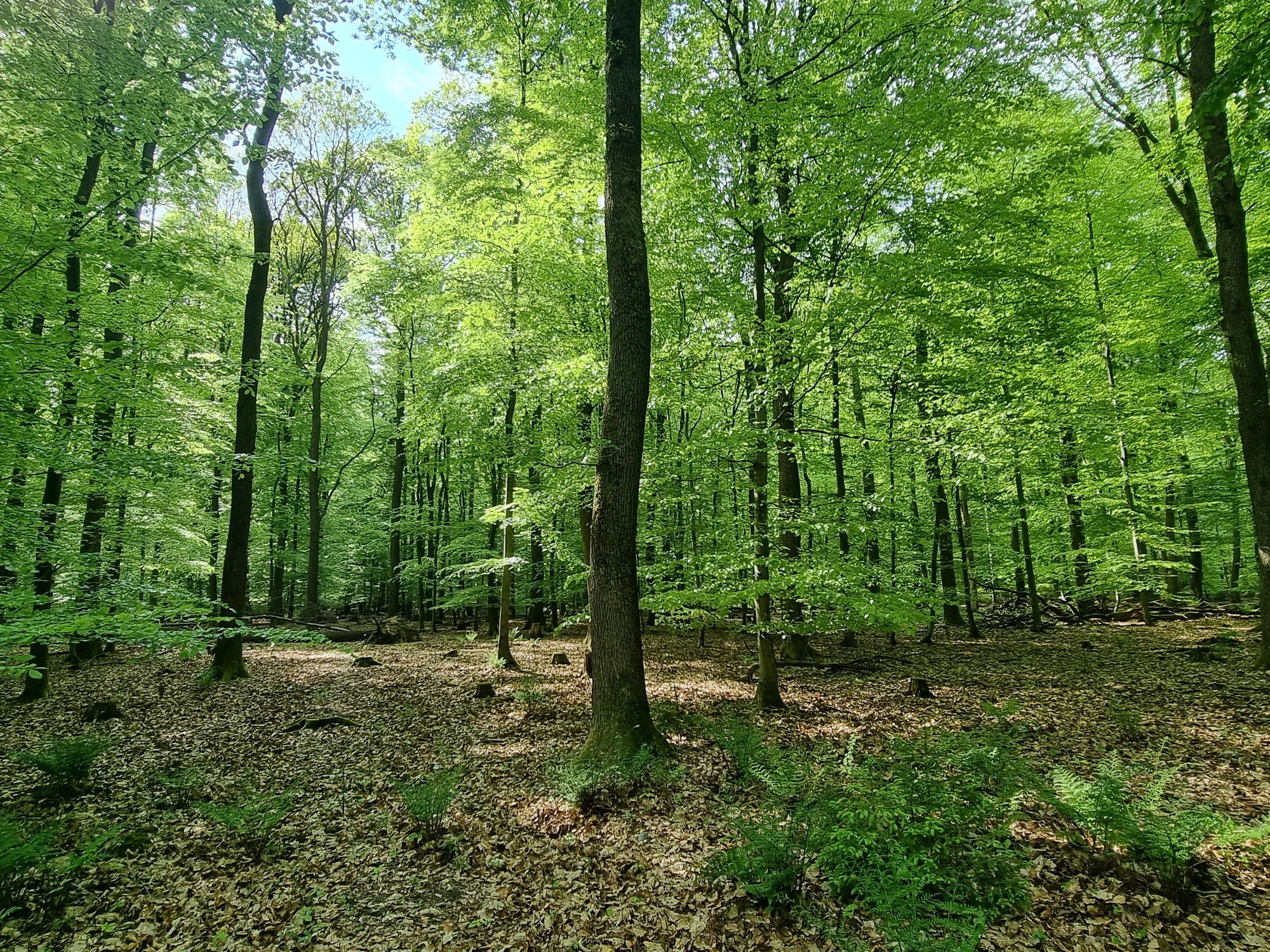
A view inside a lush, green deciduous forest in late spring with tall, slender tree trunks and a leaf-covered forest floor.
The dense, green canopy of the Wedeholz nature reserve in Lower Saxony.

Wedeholz history and protected-area timeline

Wedeholz is a relatively young protected area in administrative terms. The site was formally designated as a Lower Saxon nature reserve on 1 February 2019 under the identifier NSG LÜ 348. Since that date, the forest has been managed under the oversight of the lower nature conservation authorities of Landkreis Verden and Landkreis Rotenburg (Wümme), with the Niedersächsischer Landesbetrieb für Wasserwirtschaft, Küsten- und Naturschutz (NLWKN) acting as the responsible state-level agency.

Although the formal protection is recent, the woodland itself carries older management legacies. Parts of the forest preserve structural features of historical Hutewald, the traditional wood-pasture system in which livestock grazed beneath widely spaced trees, shaping open, gnarled oak stands. These remnants reflect a long period of human use that predates modern forestry and conservation frameworks.

In conjunction with the 2019 designation, the area was placed under European protection as an FFH area of essentially the same extent. Together, the national and European designations anchor Wedeholz into both the Lower Saxon and EU-wide networks of protected forest sites. A northern section of the reserve has additionally been designated as a Naturwaldreservat, where forest use is limited to natural processes to provide reference conditions for research and conservation monitoring.

Wedeholz landscape and geographic character

The landscape of Wedeholz is shaped by the Geest, the gently undulating sandy upland that runs across much of northwestern Germany. The reserve sits on a flat Geest hill, with elevations ranging from roughly 39 to 61 meters above sea level. This terrain is subtle rather than dramatic, defined by broad, low relief rather than valleys or ridges.

Within this lowland setting, the dominant landscape element is closed deciduous forest. Stands of pedunculate oak form the older backbone of the woodland, while European beech dominates in the Hainsimsen-Buchenwald communities that cover much of the rest of the area. In the eastern part of the reserve, the land surface becomes locally wetter, and the dry Geest forest transitions into a narrow fringe of bog habitat. Here, sphagnum-rich floating mats, sedge and cottongrass communities, and small patches of pine swamp forest give the landscape a softer, more open character and introduce standing water and peat into an otherwise dry forest setting.

A secondary landscape feature is the historical wood-pasture structure preserved in parts of the forest. Open-grown oak trees with broad crowns, scattered across grassy or herb-rich ground, reflect centuries of grazing use and stand in contrast to the denser, more uniform high forest elsewhere. The presence of the Kreisstraße 11 through the area, along with several forest paths, adds a human-scale framework to the landscape without breaking its overall forested continuity.

Wedeholz ecosystems, habitats, and plant life

Wedeholz represents a compact but ecologically layered section of the North German Geest forest landscape. Its central ecological identity is built on native deciduous woodland of pedunculate oak and European beech, forest types that historically dominated much of the sandy uplands between the Aller and the Wümme.

A defining ecological feature of the reserve is its high proportion of old and dead wood. Continuous cover of ancient trees and decaying trunks creates a network of microhabitats that support specialized communities of fungi, lichens, and invertebrates, and that sustain the reserve's value as a forest reference site, especially in its northern Naturwaldreservat section.

In the eastern part of the area, the forest gives way to a small but ecologically distinct wetland zone. Transitional and floating bog communities with sphagnum mosses, sedges, and cottongrass give way in places to pine-dominated swamp forest. This combination of dry Geest woodland and small-scale bog wetland creates a habitat mosaic that, although limited in area, spans a meaningful ecological gradient from acidic sandy upland to ombrotrophic peatland within the boundaries of a single reserve.

Wedeholz wildlife and species highlights

Wedeholz supports a particularly rich bat community for a forest reserve of its size, with at least nine species documented as resident or regularly occurring. These include the Bechstein's bat, greater mouse-eared bat, greater and lesser whiskered bats, Natterer's bat (Fransenfledermaus), common and lesser noctules, Daubenton's bat, and the serotine bat. The combination of old trees with cavities and dead wood, and the proximity of small wetland areas in the east, likely explains why this forest holds such a diverse ensemble of forest-dwelling bats.

The reserve is also an important area for cavity-breeding birds. Eagle owl, red kite, and several woodpecker species, including black, great spotted, middle, and lesser spotted woodpeckers, are characteristic of the older oak and beech stands. Additional nesters such as the stock dove, short-toed treecreeper, pied flycatcher, and spotted flycatcher reflect the availability of tree holes and decaying wood. Together, these birds underscore the value of the forest's old trees and dead-wood structures for breeding and feeding habitats.

A further wildlife dimension comes from invertebrates, particularly deadwood-dependent beetles. The reserve's substantial dead wood resource is identified as having special significance for a community of saproxylic beetle species that depend on decaying wood throughout their life cycles. While these insects are less conspicuous than birds or bats, they are a meaningful component of the reserve's biodiversity and an important reason for its FFH designation.

Wedeholz conservation status and protection priorities

Wedeholz is a small but carefully targeted conservation unit. Its designation as a Lower Saxon nature reserve in 2019 placed the forest under a clear national protection framework, while the simultaneous designation of nearly the same area as an FFH site ties Wedeholz into the European Union's Natura 2000 network and the Habitats Directive obligations this implies.

From a conservation perspective, the reserve's importance rests on three main pillars. The first is the preservation of older oak and beech stands on the Geest, forest types that have become increasingly rare in the intensively managed commercial forests surrounding the reserve. The second is the maintenance of a high share of old and dead wood, recognized as critical for forest-dwelling bats, cavity-breeding birds, and saproxylic beetles. The third is the protection of a small but ecologically distinct bog and pine swamp forest element in the east, which preserves a peatland habitat that is otherwise scarce in the local landscape.

The inclusion of part of the reserve as a Naturwaldreservat indicates that portions of the forest are deliberately allowed to develop with minimal human intervention, providing reference conditions for ecological research and conservation monitoring in Lower Saxony. The IUCN Category IV classification places Wedeholz in the category of Habitat/Species Management Areas, signaling that the site is actively managed to maintain specific habitats and species rather than being left as strict wilderness.

Wedeholz cultural meaning and human context

Wedeholz carries a quiet but real cultural landscape dimension through its surviving wood-pasture features. The presence of Hutewald remnants reflects a centuries-old tradition in northern Germany of using open oak forests for grazing livestock. In these systems, widely spaced oaks with broad crowns, often gnarled and old, stood over grassy and herb-rich ground that supported cattle, pigs, and other animals. The traces of this land use remain visible in parts of the reserve and connect the current protected forest to a much older pattern of rural life on the Geest.

The reserve also sits within a broader landscape of small Lower Saxon rural communities. It lies between the district towns of Verden (Aller) and Rotenburg (Wümme), and touches the municipalities of Kirchlinteln and Westerwalsede. Roads and forest paths passing through it link it to surrounding villages and farmlands, making the forest an integral piece of the everyday cultural and recreational geography of the two districts rather than an isolated wilderness.

Top sights and standout views in Wedeholz

Wedeholz combines older deciduous forest, small-scale bog habitat, and a strong deadwood resource within a compact reserve on the North German Geest. The forest stands include both oak and beech communities, with traces of historical Hutewald land use still visible in the structure of older oak trees.

The reserve's nine documented bat species, its community of cavity-breeding birds, and its saproxylic beetle fauna together give Wedeholz a strong reputation as a forest conservation site despite its modest size. Combined with its dual national nature reserve and FFH status, and its inclusion in part as a Naturwaldreservat, Wedeholz stands out as a representative example of ecologically rich Geest forest in Lower Saxony.

Best time to visit Wedeholz

As a forest reserve, Wedeholz offers different qualities through the seasons. Spring is a good time for listening for returning cavity-nesting birds and emerging bat activity from dusk, with fresh green beech foliage softening the otherwise dry-looking Geest forest. Early summer brings full leaf cover and dense shade in the oak and beech stands, along with active insects, including the deadwood-dependent beetle community.

Autumn is arguably the most visually rewarding period, when the beech and oak canopy turns color and the contrast between dry forest and the wet bog fringe in the east becomes especially evident. Winter offers the clearest views into the older woodland structure, with the bare canopy revealing the broad-crowned, open-grown oaks that reflect the historical Hutewald character. Quiet, mild evenings in late spring and summer are typically the most productive periods for observing bats around dusk.

Monthly climate preview

Long-term monthly temperature averages and precipitation patterns for Lower Saxony

Wedeholz Climate Normals and Representative Annual Temperature Profiles

Historical monitoring records establish the baseline annual temperature and monthly precipitation rhythm for Wedeholz across representative coordinate points. Exploring the comprehensive twelve-month profile provides deeper analytical depth regarding long-term climatic variations.
Annual mean9 °C
1 °C18 °C
Jan
Feb
Mar
Apr
May13°
Jun16°
Jul18°
Aug18°
Sep14°
Oct
Nov
Dec
Warmest month
July

18.1 °C

Coolest month
January

0.7 °C

Wettest month
July

2.5 mm/day

Driest month
April

1.4 mm/day

Park location guide

Geography guide, regional context, and park location map for Wedeholz

Wedeholz park geography, regions, and map view in Germany

Understand where Wedeholz sits in Germany through a broader geographic reading of the surrounding landscape, nearby location context, and its mapped position within the national park landscape.

How Wedeholz fits into Germany

Germany is a federal republic in Western and Central Europe with a population of over 83 million across sixteen constituent states. It is Europe's largest economy by nominal GDP and a major global exporter and importer. The capital is Berlin, and the country borders Denmark, Poland, Czech Republic, Austria, Switzerland, France, Luxembourg, Belgium, and the Netherlands.

Wider geography shaping Wedeholz in Germany

Germany is located in Western and Central Europe, spanning 357,022 km². It borders Denmark to the north, Poland and the Czech Republic to the east, Austria and Switzerland to the south, and France, Luxembourg, Belgium, and the Netherlands to the west. The country has coastlines on the Baltic Sea and North Sea to the north, with the Alps located in the southern region.

Map view of Wedeholz

Use this park location map to pinpoint Wedeholz in Germany, understand its exact geographic position, and read its mapped placement within the surrounding landscape more clearly.

Pigeon | © OpenStreetMap contributors

Location context for Wedeholz

Lower Saxony
Recorded earthquake history

View Recorded Earthquake History and Seismic Data for Wedeholz

Explore the documented history of seismic events associated by location with Wedeholz. MoriAtlas provides a clear, organized catalogue of recorded epicentres and magnitude data for this protected area, allowing for direct review of historical seismic records within the Lower Saxony region.

Wedeholz Earthquake History

Catalogued events

3 events

Strongest magnitude

Magnitude 4.5

Most recent event

Jul 15, 2005

This history includes earthquakes recorded inside the park or within 50 km of its borders

Explore visual documentation of ancient oak stands, woodland terrain, and wetland ecosystems across the reserve.

Wedeholz Photos and Landscape Scenery: Visualizing Protected Forest Habitats

Visual records illustrate the dense deciduous canopies, varied Geest topography, and rare deadwood features defining the protected woodland environment. Examining these field photographs reveals the structural diversity and ecological complexity inherent in the protected landscape.

A view inside a lush, green deciduous forest in late spring with tall, slender tree trunks and a leaf-covered forest floor.

Park atlas

Compare regional forest reserves and nearby protected landscapes

Explore Protected Areas and Parks Near Wedeholz in Lower Saxony

Visitors exploring Wedeholz can continue browsing other protected areas and forest reserves located across the surrounding Lower Saxon landscape. Expanding the geographic comparison highlights related woodland ecosystems and regional conservation networks in northern Germany.
Nature reserveLower Saxony
0.8 km away#1 closest

Northwest

Wolfsgrund Nature Reserve: Geographic Overview of Protected Heathlands in Lower Saxony

Inland dune topography and alder swamp forest ecology

Wolfsgrund represents a core protected area in Lower Saxony, defined by its unique inland dune geography and the narrow valley of the Everser Bach. The reserve encompasses a diverse ecological gradient, protecting sensitive dry heath, moist heathlands, and alder swamp forests that serve as a crucial refuge for regional biodiversity. This structured geographic overview highlights the terrain transitions and conservation significance of this essential German nature reserve.

Area
0.458 km²
Established
1977
IUCN
IV
Nature reserveNiedersachsen
About 3.8 km away#2 closest

Southwest

Waller Flachteiche Nature Reserve: Exploring the Geography of Protected Landscapes in Niedersachsen

Mapped habitats of a former sand quarry wetland

Waller Flachteiche is a state-recognized nature reserve covering over 22 hectares of sandy, lowland terrain in Germany. The protected area offers a look at a recovered industrial site, where periodically drying ponds and diverse scrubland create a specialized habitat for rare amphibians and wetland flora. Its defined boundaries highlight a critical Natura 2000 component within the broader Niedersachsen region.

Area
0.227 km²
Established
2018
IUCN
IV
Nature reserveLower Saxony
About 5.9 km away#3 closest

West

Waller Moor Nature Reserve: Geographic Context and Protected Landscape Profile

Mapping raised bog restoration in the Verden district of Lower Saxony

Waller Moor represents a focused effort to restore degraded peatland within Lower Saxony. By integrating grassland buffers and small pond habitats, the reserve preserves a specific lowland bog character. Its placement near the Spanger Holz woodland highlights the interplay between protected core habitats and managed regional terrain in northern Germany.

Area
0.25 km²
Established
1985
IUCN
IV
Relief
Lowland
Nature reserveLandkreis Rotenburg (Wümme)
7.8 km away#4 closest

Northeast

Wümmeniederung mit Rodau, Wiedau und Trochelbach: Protected Wetland and Heath Landscape

Regional geography and floodplain connectivity in Landkreis Rotenburg

This nature reserve protects a sprawling lowland landscape characterized by the Wümme, Rodau, Wiedau, and Trochelbach rivers. The terrain features a mosaic of near-natural meandering streams, species-rich wet meadows, and rare raised bog remnants, providing a comprehensive overview of northern German lowland ecology.

Area
28.96 km²
Established
2020
IUCN
IV
Relief
Lowland
Nature reserveLower Saxony
About 10 km away#5 closest

Southeast

Verdener Moor Nature Reserve: Geographic Atlas and Protected Area Context

Preserving raised bog ecosystems in Lower Saxony, Germany

Located in the municipality of Kirchlinteln, Verdener Moor functions as a protected nature reserve that demonstrates lowland peatland conservation. The landscape features a distinct mosaic of open water resulting from historical peat extraction, wet heath, and rewilded forest edges. This site offers valuable insight into the restoration of bog habitats through rewetting and bush removal within the broader geography of Lower Saxony.

Area
0.91 km²
Established
1989
IUCN
IV
Relief
Lowland
Nature reserveLower Saxony
13 km away#6 closest

North

Stellmoor und Weichel: Geographic Profile of a Lower Saxony Nature Reserve

Protected geest woodlands and peat-bog mosaic landscapes

Examine the territorial boundaries and ecological features of Stellmoor und Weichel. Located on the flat geest ridge of Northern Germany, this reserve maps the transition from managed deciduous woodland to complex mire, willow thicket, and bog-fringe water systems, maintaining a long-standing natural forest reserve status.

Area
2.18 km²
Established
2018
IUCN
IV
Nature reserveLower Saxony
About 16 km away#7 closest

North

Wiestetal Nature Reserve: Mapping the Wieste Stream and Riparian Habitat Corridor

Protected floodplain geography in Lower Saxony, Germany

Wiestetal acts as a critical nature reserve between Mulmshorn and Ottersberg, protecting the unique ecological character of the Wieste lowland stream. The area is defined by its meandering water channels, flooded sand quarry ponds, and diverse forest edges that sustain local biodiversity. This protected landscape offers a detailed look at the interplay between glacial sand deposits and the vibrant aquatic ecosystems of Northern Germany.

Area
3.82 km²
Established
2013
IUCN
IV
Relief
Upland
Nature reserveLandkreis Rotenburg (Wümme)
About 18 km away#8 closest

North

Westliches Borchelsmoor Nature Reserve: Geographic Profile and Protected Bog Landscape

A preserved peatland fragment in the Landkreis Rotenburg district.

Located in northern Lower Saxony, Westliches Borchelsmoor represents a significant remnant of the historical Borchelsmoor raised bog. The reserve showcases a complex topography of old drainage lines and birch woodland, providing a clear window into the ecological transition of modified moorland. This site serves as a core component of the local wetland mosaic and offers valuable insights into ongoing peatland restoration and bog conservation.

Area
1.25 km²
Established
2010
IUCN
IV
Relief
Lowland

Common questions about visiting, size, designation, and location context for Wedeholz

Wedeholz FAQs for park facts, access, geography, and protected area context

Find quick answers about Wedeholz, including protected-area facts, park geography, trail and visitor context, and how the park fits into its surrounding country and regional landscape.
MoriAtlas Explorer

Continue Your Protected Areas Search Across the Global Atlas

Deepen your exploration by continuing the structured search for national parks and protected areas worldwide. Utilize the comprehensive filtering capabilities to compare different conservation landscapes and refine your understanding of global park geography. Discover more about the distribution and characteristics of protected natural areas.

Global natural geography