Mori Atlas logo
Protected landscapeWildnispark Zürich

Tracing the mapped boundaries of this forest reserve and wildlife area near Zürich

Wildnispark Zürich: An In-Depth Look at its Protected Landscape and Regional Geography

(Stiftung Wildnispark Zürich)

Wildnispark Zürich serves as a vital protected landscape within the Zürich metropolitan region, encompassing a unique blend of near-natural deciduous woodland and native wildlife habitat. This area comprises the extensive Sihlwald forest, recognized for its natural significance, alongside the Langenberg wildlife grounds. The park provides a critical connection to European woodland ecology, featuring diverse terrain from the Sihl river valley to the rolling slopes of the Albis ridge.

nature experience parkmixed forestbeech forestwildlife parknative European speciesurban-adjacent nature reserve

Wildnispark Zürich

Protected landscape

Park overview

Structured park overview, official facts, and landscape profile for Wildnispark Zürich

Wildnispark Zürich park facts, protected area profile, and essential visitor context

Review the core facts for Wildnispark Zürich, including designation, size, terrain, visitor scale, habitats, and operating context in one park-focused overview.

About Wildnispark Zürich

Wildnispark Zürich sits on the southwestern edge of the Zürich metropolitan area, occupying forested terrain that stretches between the Albis range and the Sihl valley. It is not a remote wilderness in the traditional alpine sense; instead it represents an unusually large and well-preserved tract of forest that has survived within an otherwise heavily urbanized region of central Switzerland. The park was assembled to ensure that this forest, and the animal experiences associated with it, remain publicly accessible and ecologically managed rather than being lost to expanding suburbs or commercial forestry.

The park is structured around two distinct but linked areas. The Naturerlebnispark Sihlwald is the larger forested component and functions as the ecological heart of the site, with a long-established tradition of protected forestry, hiking trails, a visitor center with interpretive exhibits, and educational programming aimed at schools, families, and the general public. The Tierpark Langenberg, located nearby in Langnau am Albis, complements this forest landscape by bringing visitors into close contact with European mammals whose wild counterparts are often difficult to observe. Together, the two sites create a combined nature experience that is unusual within Switzerland for its scale, proximity to a major city, and explicit focus on forest and native-wildlife education.

The organization was formed through the merger of two earlier Zürich institutions: Naturlandschaft Sihlwald, which had championed the protected forest, and Wildpark Langenberg, which had run the animal park. By combining them under the Stiftung Wildnispark Zürich, the city sought to unify management, strengthen conservation outcomes, and broaden public access to nature. The foundation now serves one of the densest population corridors in the country, providing a substantial natural landscape for residents of Zürich, Zug, and Luzern who otherwise have limited exposure to large protected forest environments.

In addition to its conservation work, the park plays a significant role in environmental education and outreach. Its visitor center at Sihlwald anchors a year-round program of guided walks, themed trails, school workshops, and seasonal events. The Langenberg site focuses on animal welfare standards and interpretive displays that contextualize native species within their historical European habitats, including an exhibition in the so-called Elchhaus that highlights the reintroduction and ecological recovery of large herbivores such as wisent, red deer, and wild boar.

Quick facts and research context for Wildnispark Zürich

Wildnispark Zürich is a foundation-run nature park in the canton of Zürich, Switzerland. It is composed of two complementary sites: the Naturerlebnispark Sihlwald, which functions as a large forest wilderness and nature experience reserve, and the Tierpark Langenberg, which presents native European wildlife in naturalistic enclosures. The combined area covers roughly twelve square kilometers.

The Sihlwald portion holds the distinction of being the first Swiss landscape to be awarded the federal Naturerlebnispark label, recognizing its national significance. The foundation runs year-round educational programming, including several hundred public events each summer season, and maintains a visitor and exhibition center in the historic hamlet of Sihlwald.

Protection and recognition

Terrestrial conservation management scope and official designation records

Wildnispark Zürich Protection Status and Designated Area History

Wildnispark Zürich maintains documented terrestrial protection status established in two thousand ten. Conservation records outline the administrative management scope and designation history for the protected area.

Protection details

Protection scope
Terrestrial
Designated year
2010
Transboundary protection
No
Park context

Deeper park guide and search-rich context for Wildnispark Zürich

Wildnispark Zürich history, landscape, wildlife, and travel context

Explore Wildnispark Zürich through its history, landscape character, ecosystems, wildlife, conservation priorities, cultural context, and seasonal travel timing in a structured park guide built for atlas discovery and search intent.

Why Wildnispark Zürich stands out

Wildnispark Zürich is best known for pairing a sizeable near-natural forest reserve with one of Switzerland's most visible native-animal parks within easy reach of a major city. The Sihlwald side is recognized for its extensive beech and mixed deciduous forest, its protected status as a national-level Naturerlebnispark, and its trails, visitor center, and educational programming. The Langenberg side is known for showcasing the large herbivores that once lived across Central European lowland forests, including wisent, red deer, and wild boar, presented as part of a broader story about the historical and ecological reconnection of European woodland fauna.
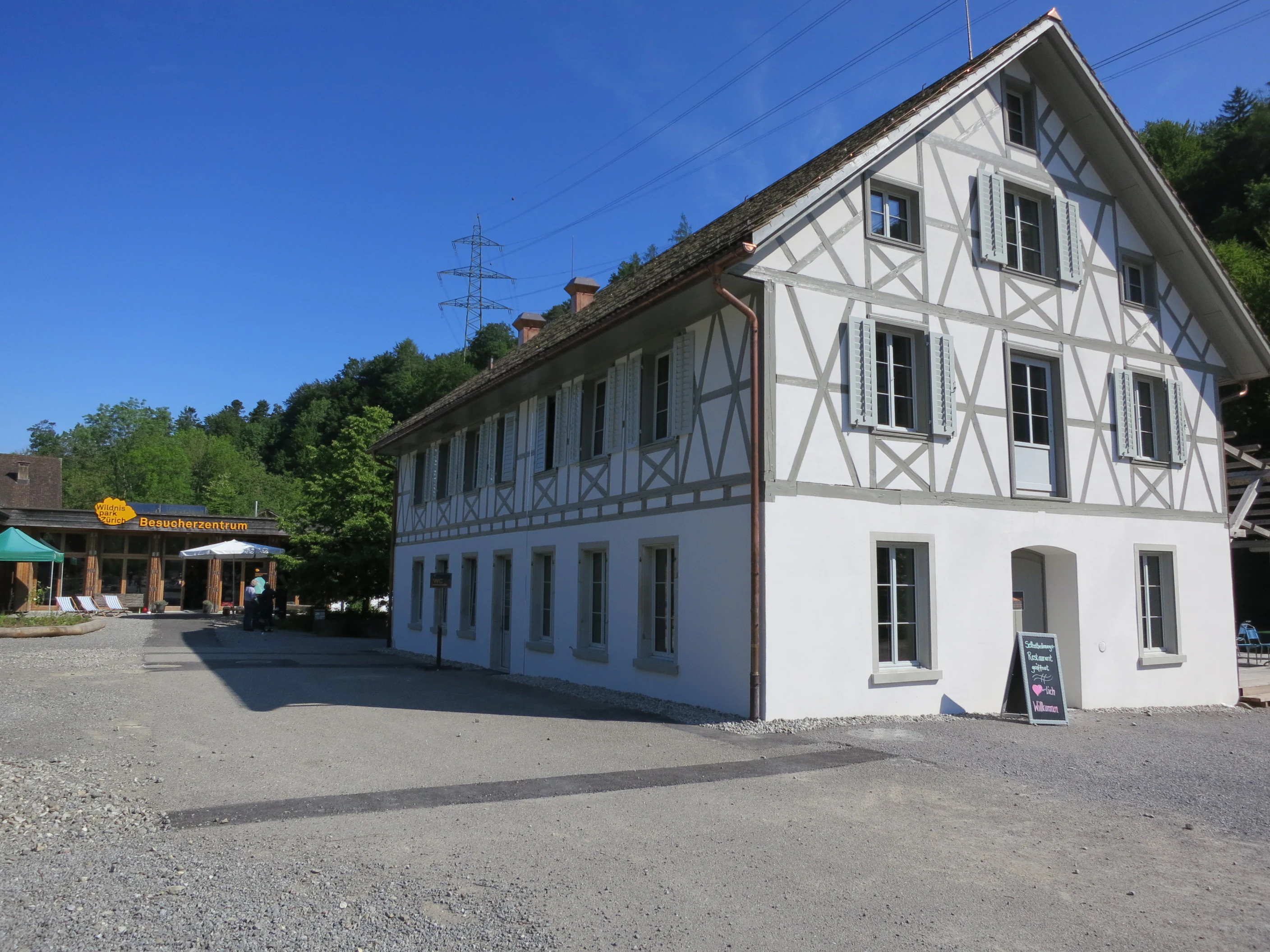
A traditional timber-framed building serving as a visitor center, situated in a park area with a gravel courtyard and forested hillside in the background.
The visitor center at Sihlwald in Wildnispark Zürich.

Wildnispark Zürich history and protected-area timeline

Wildnispark Zürich took its current form in 2009, when the Stiftung Wildnispark Zürich was established by bringing together two predecessor organizations. The first of these, Naturlandschaft Sihlwald, had long been associated with the effort to protect the Sihlwald forest as a continuous, near-natural woodland under a sustainable management model. The second, the Wildpark Langenberg, had operated the animal park near Langnau am Albis as a destination focused on native European species. Their merger created a single foundation with a unified mission across the two sites.

A key milestone arrived on 1 January 2010, when the Sihlwald area became the first region in Switzerland to receive the federal label of Naturerlebnispark, a category reserved for parks of national significance. This designation recognized both the ecological value of the forest and its potential as a public nature experience area. Since then the foundation has continued to expand its programming, infrastructure, and visitor services, building the Sihlwald visitor center, developing interpretive trails, and growing an annual program that includes several hundred public events during the summer season. The park has become a model for nature experience areas situated close to major urban populations.

Wildnispark Zürich landscape and geographic character

The dominant landscape of Wildnispark Zürich is forested rather than alpine. The Sihlwald section occupies a long stretch of the lower Sihl valley and the slopes rising from it, characterized by continuous mixed deciduous woodland with a strong beech component. The terrain is gently to moderately steep, crossed by streams and small ravines, and accessible through a dense network of forest paths. It is one of the largest contiguous forest tracts remaining on the Swiss Mittelland, which gives it a landscape character closer to a Central European hill forest than to the higher alpine zones farther south.

The Langenberg site lies in a more open setting near the Albis ridge, with meadow and edge habitats that suit the parkland-like enclosures used for its hoofed animals. Viewpoints in the surrounding area look out over the Zürich lowlands, reinforcing how this landscape feels embedded within, rather than separated from, the urban region. Together the two sites illustrate how a working forest landscape and a curated wildlife park can coexist within a single foundation-managed nature area.

Wildnispark Zürich ecosystems, habitats, and plant life

The ecological significance of Wildnispark Zürich rests heavily on the Sihlwald forest. Its long history of continuous forest cover and selective, near-natural management practices has allowed it to retain structural diversity, including mature trees, standing deadwood, and layered understory, that many lowland forests in central Europe have lost. This makes the area important for forest-dependent species, from forest-floor invertebrates and mosses to cavity-nesting birds and larger mammals that depend on undisturbed canopy.

The park's broader ecological identity is framed by the concept of a near-natural Central European woodland, supported by watercourses associated with the Sihl river system, edge habitats, and small clearings. The Tierpark Langenberg rides on this ecological theme, presenting species that belong to the same forest and forest-edge community that shaped European landscapes for millennia. This pairing of a real forest and a themed wildlife display is the practical expression of the foundation's ecological identity.

Wildnispark Zürich wildlife and species highlights

The wildlife character of Wildnispark Zürich is split between the wild fauna of the Sihlwald forest and the curated collection at the Tierpark Langenberg. Within Sihlwald, typical forest fauna includes red deer, roe deer, and wild boar, along with smaller mammals, bats, and a varied forest bird community. The protected forest structure provides habitat for species associated with mature deciduous woodland, although encounters with larger mammals tend to be discreet and are often associated with quieter parts of the reserve.

Langenberg brings many of these same species, plus others that are now rare or locally extinct in Switzerland, into clear public view. The park is known for its herds of wisent, the European bison, as well as red deer, wild boar, and other large herbivores that historically shaped lowland forest ecosystems. Interpretive displays, including the exhibition in the Elchhaus, frame these animals in terms of their ecological role and gradual return to wider parts of the European landscape. For visitors, the wildlife experience in Wildnispark Zürich is as much about understanding these animals as it is about seeing them.

Wildnispark Zürich conservation status and protection priorities

Wildnispark Zürich occupies an important conservation niche by protecting a large, near-natural forest complex inside one of Switzerland's most urbanized regions. The Sihlwald site functions as a refuge for lowland forest biodiversity, supported by a management approach that emphasizes the continuation of natural forest processes rather than intensive timber production. Its national-level Naturerlebnispark status reinforces the recognition that such forests deserve both ecological protection and active public engagement.

At Langenberg, conservation work is expressed through breeding, welfare, and educational efforts centered on native European species, particularly large herbivores that have been lost from much of their former range. By maintaining healthy populations of animals such as wisent and red deer in conditions that reflect their natural habitats, the foundation contributes to the broader European effort to restore functional herbivore communities in temperate forests. Together, the two halves of the park demonstrate that conservation in a densely populated country can extend beyond strict reserves into everyday public landscapes.

Wildnispark Zürich cultural meaning and human context

The cultural framing of Wildnispark Zürich centers on the relationship between a major Swiss city and the surrounding natural landscape. Within the Zürich region, the Sihlwald forest has long been valued as a place of recreation, with walking, cycling, and family outings traditionally tied to the Sihl valley. The creation of the foundation and the federal nature park designation formalized this relationship, recasting the forest from a familiar recreational backdrop into a nationally recognized protected landscape.

At the same time, the Langenberg animal park connects visitors to a wider European cultural memory of shared woodland fauna: the bison, deer, and boar that appear in folklore, hunting tradition, and natural history across the continent. The Elchhaus exhibition reflects this storytelling dimension by explicitly linking the living animals to a narrative of ecological recovery. The overall cultural role of the park is therefore as much about shaping a regional identity of urban nature access as it is about conserving species.

Top sights and standout views in Wildnispark Zürich

Two complementary sites in one foundation-run park: a large forest-based Naturerlebnispark and a native-species wildlife park. The Sihlwald area is recognized as the first Swiss Naturerlebnispark under the federal label of national significance. The full park is unusually large for an urban-adjacent nature area, covering roughly twelve square kilometers of forest and wildlife habitats within the Zürich metropolitan region.

The Tierpark Langenberg offers one of the most accessible views in Switzerland of large European herbivores such as wisent, red deer, and wild boar, presented within an interpretive framework that connects visitors to the historical ecology of Central European woodlands. The Sihlwald visitor center anchors a wide-ranging program of guided tours, school visits, and seasonal events that make the forest a year-round destination.

Best time to visit Wildnispark Zürich

The character of a visit to Wildnispark Zürich shifts with the seasons in ways that are typical of Central European lowland forests. Spring brings fresh green growth, active birdlife, and the opening of the main season of guided events, which generally runs from late March through late October.

Summer is the most program-rich period, with several hundred organized events and warm conditions for extended walking in the forest. Autumn is often considered particularly atmospheric in Sihlwald, when beech and mixed deciduous foliage turn and the forest floor comes alive with fungi. Winter visits are quieter and colder, with snow occasionally transforming the trails, but the wildlife park and visitor center remain accessible year-round, offering a calmer experience focused on the structural beauty of the bare forest and viewing of hardy native animals.

Monthly climate preview

Long-term representative coordinate measurements mapping twelve-month environmental cycles

Wildnispark Zürich Climate Normals, Annual Temperature and Precipitation Rhythms

Representative coordinates record measured monthly temperature ranges and precipitation rates across the landscape over a thirty-year climatology period. Detailed twelve-month climate profiles document the full annual progression of thermal averages and moisture patterns for the conservation area.
Annual mean9 °C
-1 °C18 °C
Jan-1°
Feb
Mar
Apr
May13°
Jun17°
Jul18°
Aug18°
Sep14°
Oct
Nov
Dec
Warmest month
July

18.4 °C

Coolest month
January

-0.7 °C

Wettest month
June

4.6 mm/day

Driest month
February

2.6 mm/day

Park location guide

Geography guide, regional context, and park location map for Wildnispark Zürich

Wildnispark Zürich park geography, regions, and map view in Switzerland

Understand where Wildnispark Zürich sits in Switzerland through a broader geographic reading of the surrounding landscape, nearby location context, and its mapped position within the national park landscape.

How Wildnispark Zürich fits into Switzerland

Switzerland is a landlocked federal republic in Central Europe comprising 26 cantons, with Bern as the federal city and Zurich as the largest city. The country features the Swiss Alps, Swiss Plateau, and Jura Mountains, with German, French, Italian, and Romansh as official languages. It is noted for its political neutrality, direct democracy traditions, and strong economy.

Wider geography shaping Wildnispark Zürich in Switzerland

Switzerland is located in Central Europe at the intersection of Western and Southern Europe. It is bordered by Germany to the north, France to the west, Austria and Liechtenstein to the east, and Italy to the south. The country is geographically divided among the Swiss Alps (covering most of the territory), the Swiss Plateau (where most of the population resides), and the Jura Mountains. Switzerland is landlocked.

Map view of Wildnispark Zürich

Use this park location map to pinpoint Wildnispark Zürich in Switzerland, understand its exact geographic position, and read its mapped placement within the surrounding landscape more clearly.

Pigeon | © OpenStreetMap contributors

Location context for Wildnispark Zürich

Zürich
Recorded earthquake history

Examine the Historical Earthquake Record for Wildnispark Zürich

Explore documented seismic events associated with the geographical area surrounding Wildnispark Zürich. This curated MoriAtlas record provides an accessible catalogue of historical earthquake data to support your understanding of seismic activity patterns in the vicinity of this Swiss protected landscape.

Wildnispark Zürich Earthquake History

Catalogued events

52 events

Strongest magnitude

Magnitude 4.6

Most recent event

Jun 4, 2024

This history includes earthquakes recorded inside the park or within 50 km of its borders

Visual exploration of forest terrain, protected habitats, and wildlife

Wildnispark Zürich Photos and Landscape Scenery

Visual documentation captures the contiguous mixed deciduous woodland and native wildlife enclosures defining the protected area. Examining field photography reveals the distinct topography and habitat character shaped across the Mittelland region.

A traditional timber-framed building serving as a visitor center, situated in a park area with a gravel courtyard and forested hillside in the background.

A vertical information sign situated in a forest, displaying a detailed color-coded map of the Wildnispark Zürich with the words KERN ZONE at the top.

Park atlas

Compare regional forest reserves and nearby protected areas across the surrounding terrain

Exploring Parks Near Wildnispark Zürich and Connected Protected Landscapes

Visitors exploring Wildnispark Zürich can continue browsing other regional parks to compare contiguous forest tracts and protected landscapes across the surrounding region. Examining adjacent natural areas provides broader context on Central European woodland reserves and urban-adjacent conservation sites.
A soft watercolor painting of undulating green hills, meadows, and a winding path against a white background.
Protected landscapeSwitzerland
About 6.1 km away#1 closest

Southeast

Glaziallandschaft Lorze, Sihl mit Höhronenkette und Schwantenau: Landscape and Terrain Atlas

A study of glacial formations and protected Swiss ecosystems.

Trace the moraine-dominated terrain and river gorges of this nationally recognized protected landscape. From the drumlin fields near Menzingen to the rare peatland habitats of the Schwantenau, this area offers a comprehensive look at the geological and hydrological history of the Swiss Pre-Alps.

Area
10.808 km²
Relief
Mountain
Climate
Alpine
Access
Moderate access
A watercolor painting showing soft rolling green hills, a few small trees, and distant hazy mountain silhouettes under a pale sky.
Nature reserveSchwyz
About 25 km away#2 closest

Southeast

Ibergeregg Nature Reserve: Mapped Protected Landscapes and Alpine Geography of Schwyz

A highland pass and wetland ecosystem in the Swiss pre-Alps

The Ibergeregg nature reserve represents a high, flat saddle in the Schwyz pre-Alps, serving as a landmark for its expansive raised bogs, flat moors, and protected moor forest systems. This documentation details the geographic features, watershed position, and protected status of the pass as it transitions from alpine pasture to high-altitude wetland habitat.

Relief
Mountain
Climate
Alpine
Access
Easy access
Scope
Terrestrial
A soft watercolor painting of a wetland landscape with rolling hills, grassy plains, and gentle water channels in muted green and pink tones.
Nature reserveSt. Gallen
30 km away#3 closest

East

Kaltbrunner Riet Nature Reserve and Wetland Landscape in the Canton of St. Gallen

Mapping the protected fen habitats and agricultural wetland remnants of the Linthebene.

Kaltbrunner Riet serves as a primary nature reserve in the canton of St. Gallen, encompassing critical lowland fen and amphibian spawning habitats. As a protected Ramsar wetland, the reserve offers an essential window into the historic Linthebene landscape, showcasing how traditional meadow management sustains biodiversity across the Swiss plateau.

Area
0.5 km²
Established
1914
Relief
Lowland
Climate
Temperate
Nature reserveAargau
39 km away#4 closest

Northwest

Klingnauer Stausee Nature Reserve: Aargau Wetland and Aare River Floodplain Landscapes

Protected riparian habitat in the northern Swiss Jura

Klingnauer Stausee stands as a primary example of integrated hydropower and conservation. This artificial reservoir and its surrounding wetlands, located in the Aargau region, encompass a variety of protected habitats ranging from open still waters to alluvial forests. These landscapes provide essential refuge for migratory waterbirds and preserve unique remnants of the historical Aare River floodplain structure.

Area
1.16 km²
Established
1935
Relief
Lowland
Climate
Temperate
A watercolor painting showing a panoramic view of green rolling hills and wooded ridges under a soft light.
Regional parkAargau
About 41 km away#5 closest

Northwest

Jurapark Aargau: Geographic Overview of a Swiss Regional Nature Park and Jura Landscapes

Protected Jura mountain terrain and regional landscape mapping

Located in northern Switzerland, Jurapark Aargau encompasses a vast, connected perimeter defined by the interaction of tabular limestone plateaus and dramatic folded mountain ridges. This regional nature park serves as an essential refugium for native flora, preserving ancient geological history through fossil-rich sediments, steep escarpments, and traditional rural land use that persists between the Aargau, Zurich, and Basel regions.

Area
299 km²
Established
2012
Relief
Mountain
Climate
Temperate
A soft watercolor painting of rolling hills and distant mountains in light green and muted tones.
Biosphere reserveLucerne
41 km away#6 closest

Southwest

Entlebuch Biosphere Reserve: Mapped Protected Landscapes in the Canton of Lucerne

Exploring karst formations and alpine wetland ecosystems

Entlebuch stands as a pioneering example of community-driven conservation in the Swiss Alps. This protected landscape encompasses extensive peatlands, forested slopes, and the iconic Schrattenfluh karst massif. Use this geographic entry to understand the regional topography and the spatial distribution of protected habitats throughout this central Swiss valley.

Area
397 km²
Established
2001
Relief
Mountain
Climate
Alpine
Watercolor painting of a river landscape with lush green riverbanks, patches of grass in the foreground, and gentle rolling hills in the background.
Protected landscapeAargau
About 41 km away#7 closest

Northwest

Aarelandschaft bei Klingnau: A Protected Riverine Landscape in Northern Switzerland

Wetland geography, alluvial forests, and floodplain corridors

The Aarelandschaft bei Klingnau preserves a unique riverine mosaic where the Aare River meets the Rhine in northern Aargau. This protected landscape encompasses the Klingnauer Stausee reservoir, rich alluvial forests, and remnant oxbows. It serves as a vital migratory node for avian populations and provides a structured look at the interplay between human-engineered power infrastructure and protected natural river channels.

Area
3.6 km²
Established
1996
IUCN
V
Relief
Lowland
Nature reserveBaden-Württemberg
45 km away#8 closest

North

Blumberger Pforte und Mittlere Wutach: Protected Landscape and Gorge Geography

Nature reserve terrain and ecological atlas in Baden-Württemberg

This protected area captures the dramatic transition where the Wutach river cuts through limestone strata. Discover a rugged landscape mosaic featuring canyon forests, juniper heaths, and karst cave systems across the Swabian Alb and Black Forest fringe. The site offers significant value for understanding regional ecological gradients and limestone-dependent plant communities within the broader southern German geography.

Area
63.25 km²
Established
2019

Common questions about visiting, size, designation, and location context for Wildnispark Zürich

Wildnispark Zürich FAQs for park facts, access, geography, and protected area context

Find quick answers about Wildnispark Zürich, including protected-area facts, park geography, trail and visitor context, and how the park fits into its surrounding country and regional landscape.
MoriAtlas Explorer

Continue Your Protected Areas Search Across the Global Atlas

Deepen your exploration by continuing the structured search for national parks and protected areas worldwide. Utilize the comprehensive filtering capabilities to compare different conservation landscapes and refine your understanding of global park geography. Discover more about the distribution and characteristics of protected natural areas.

Global natural geography