
Mori Atlas logo
Nature reserveWinkel

Tracing the mapped boundaries and wetland terrain of this protected morainic ecosystem

Winkel Nature Reserve: A Detailed Geographic Atlas of Glacial Kettle Landscapes in Brandenburg

Winkel Nature Reserve preserves a distinct humid ground moraine landscape within the Uckermark district of Brandenburg. This protected area offers deep geographic insight into the formation of kettle holes and circular glacial depressions. By mapping these specialized aquatic habitats, the record provides a clear understanding of the environmental mosaic created by the last glaciation across this northeastern German region.

wetlandkettle holesSölleglacial landscapeground morainenature reserve
A flat vector illustration of a forested river valley with rocky banks, pine trees, and distant canyon walls.

Winkel

Nature reserve

Park overview

Structured park overview, official facts, and landscape profile for Winkel Nature Reserve

Winkel Nature Reserve park facts, protected area profile, and essential visitor context

Review the core facts for Winkel Nature Reserve, including designation, size, terrain, visitor scale, habitats, and operating context in one park-focused overview.

About Winkel Nature Reserve

Winkel Nature Reserve is a compact protected area in the rural northeastern German state of Brandenburg, situated in the Uckermark district near the small community of Ringenwalde. With an area of approximately 145 hectares, it is one of many relatively small nature reserves in the region, but its ecological value derives from the quality and character of its terrain rather than its size.

The reserve sits within a glacial landscape shaped during the retreat of the last ice age, when retreating ice sheets left behind a rolling ground moraine surface punctuated by depressions. Some of those depressions filled with water, forming the small circular ponds and pools known as Sölle that give the Winkel area its distinctive pattern of wetland patches set within fields and forest edges. The spatial arrangement of forest, open land, ponds, and wet depressions creates a mosaic that supports varied plant and animal communities, particularly those associated with standing freshwater and wet margins.

Although Winkel is not a national park or a UNESCO-listed site, it plays a meaningful role in the regional conservation network. It is part of a broader cluster of nature reserves in the Uckermark that together safeguard the ecological character of this glacially formed landscape, including neighbouring protected areas such as Endmoränenlandschaft bei Ringenwalde and the Libbesickesee area. Its designation status as an IUCN Category IV site underscores that its protection objective is the active maintenance of species and habitat features rather than the preservation of a large-scale wild ecosystem.

Quick facts and research context for Winkel Nature Reserve

Winkel is a nature reserve (Naturschutzgebiet) located in Brandenburg, Germany, within the Uckermark district and on the administrative territory of the municipality of Temmen-Ringenwalde. The protected area covers about 145 hectares and was officially designated on 1 October 1990 under the identifier 1059.

Its conservation significance lies in preserving the small-scale lakes, ponds, and wetland depressions of a kettle-rich ground moraine landscape. The site is classified as a Category IV protected area in the IUCN system, indicating a habitat and species management reserve. It sits within a broader cluster of Uckermark reserves that protect the region's post-glacial hydrological features.

Protection and recognition

Examining documented conservation status, official boundaries, and Natura 2000 records for Winkel

Winkel Protection Status and International Recognition Records

Winkel maintains verified status within structured protected area registries, incorporating official Natura 2000 recognition records. Documentation details the designated boundaries and international framework context associated with the protected landscape.
Park context

Deeper park guide and search-rich context for Winkel Nature Reserve

Winkel Nature Reserve history, landscape, wildlife, and travel context

Explore Winkel Nature Reserve through its history, landscape character, ecosystems, wildlife, conservation priorities, cultural context, and seasonal travel timing in a structured park guide built for atlas discovery and search intent.

Why Winkel Nature Reserve stands out

Winkel is best known for protecting a humid, kettle-hole rich ground moraine landscape in the Uckermark, a terrain type typical of the young morainic belt of northeastern Brandenburg. The Sölle, or small circular kettle lakes and pools formed by melting blocks of buried glacial ice, are the defining geomorphological feature of the area. The reserve's significance is closely tied to these water bodies and the wetland habitats surrounding them. Such environments support specialized aquatic flora and fauna and are increasingly rare outside protected areas. Together with the nearby Libbesickesee and Krummer See, Winkel contributes to the regional network of small glacial lakes and ponds that characterize the southern Uckermark countryside.
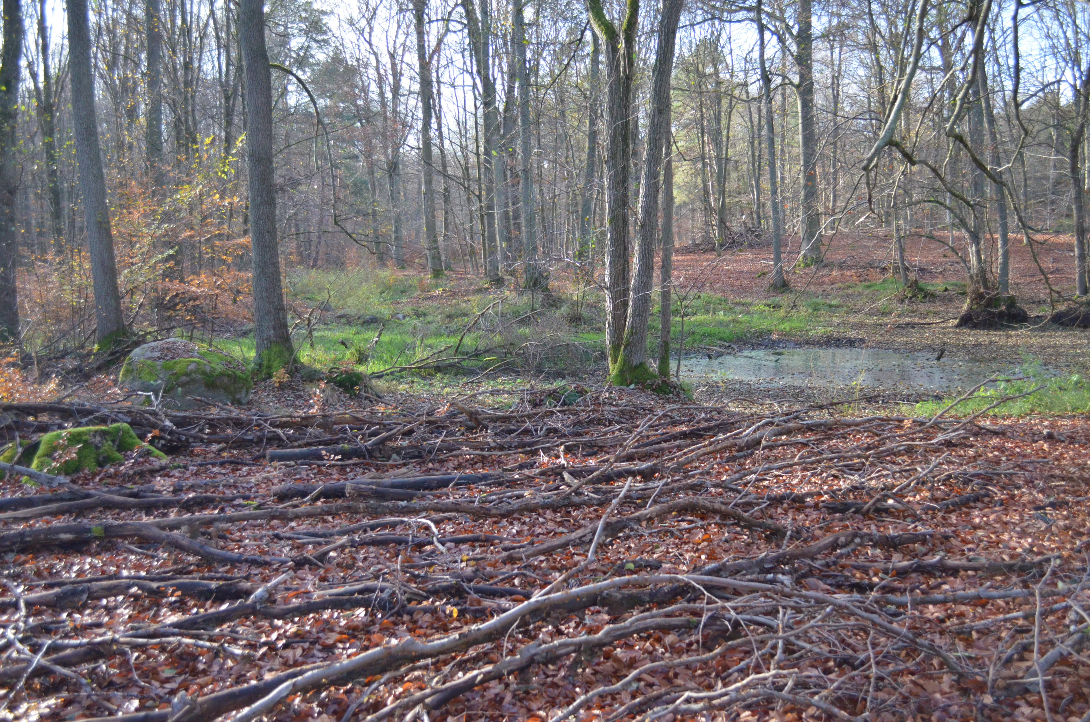
A small, still pond sits in the middle of a deciduous forest floor covered with fallen leaves and twigs.
A small pond nestled within the woodland of Winkel Nature Reserve.

Winkel Nature Reserve history and protected-area timeline

The Winkel reserve was established on 1 October 1990, in the immediate aftermath of German reunification. Its designation reflects the wave of new nature reserve proclamations in the former East German states during 1990 and the early 1990s, as the conservation framework of the German Basic Law and federal nature protection law was extended to the new federal states of the reunified country.

Under the official designation number 1059, the area was placed under formal nature protection to safeguard its wetlands, kettle-hole water bodies, and the surrounding ground moraine landscape. The early post-reunification designation reflects both the ecological value of the site and the broader political impetus to formally protect longstanding landscape features that had previously been managed under different administrative structures.

Since that initial designation, the reserve has continued to function as a managed habitat and species protection area within the German system of Naturschutzgebiete, and it remains listed in international databases such as the World Database on Protected Areas under the identifier 166330. There is little publicly documented detail about later events such as boundary changes or management plans, reflecting the largely quiet administrative profile of the reserve.

Winkel Nature Reserve landscape and geographic character

The landscape of Winkel is defined by the gentle topography of a Weichselian ground moraine, a terrain type that dominates much of northeastern Brandenburg. Ground moraines are formed from deposits of material beneath a glacier, and across the Winkel reserve they appear as a softly undulating surface with subtle rises and depressions. While elevations are modest, the irregular surface plays an important ecological role by collecting water in low-lying areas.

The most visually distinctive feature of the reserve is the presence of numerous Sölle, small, often circular ponds and water-filled depressions formed when blocks of ice became buried in glacial sediments and later melted, leaving voids that filled with water. In the Winkel reserve these Sölle, sometimes appearing as small boggy pools or marshy hollows, are scattered through the landscape and create a patchwork of wet and drier land.

To the northwest of the reserve lies the Libbesickesee and to the southeast the Krumme See, both larger lake basins that frame Winkel within a wider lake-rich setting. Combined with the small internal ponds, the area exemplifies the small-scale lake and kettle landscape that characterizes the southern Uckermark, where glaciation has produced a high density of standing water features of varying size.

Winkel Nature Reserve ecosystems, habitats, and plant life

Ecologically, Winkel belongs to the typical wetland and aquatic habitat complex of the young morainic belt of northern Brandenburg. The interaction of fine-grained glacial deposits with locally variable drainage has produced a mosaic that includes shallow standing water, wet meadow margins, marshy depressions, and drier morainic ridges, supporting a fairly diverse range of microhabitats.

The protected area is intended, by declaration, to conserve and restore habitats for threatened plant and animal species associated with kettle-hole environments. Small water bodies like the Sölle, especially in agricultural landscapes, are known for supporting specialized aquatic and semi-aquatic vegetation, as well as invertebrates and amphibians that depend on standing water for parts of their life cycle.

The broader habitat pattern described by the Soll-rich, waterlogged Grundmoränenlandschaft emphasizes that the ecological identity of Winkel is defined less by any single habitat than by the landscape-level combination of glacial geomorphology and characteristic hydrology. This combination, where small ponds and wet hollows alternate with drier moraine soil, is itself a habitat type of conservation interest.

Winkel Nature Reserve wildlife and species highlights

Although detailed species inventories are not documented in the source material, the ecological character of Winkel implies the wildlife associations typical of small kettle ponds in northeastern German moraine landscapes. Such areas tend to support amphibian populations, including frogs and newts that use seasonal pools for breeding, as well as aquatic invertebrates associated with small, vegetated standing waters.

Birds drawn to shallow water, marshy edges, and the mix of open and wooded environments are also part of the typical fauna of this habitat mosaic. Wet meadow and reed-fringed margins around the Sölle provide nesting and feeding habitats for water-associated bird species, while the surrounding drier ground moraine offers habitat for woodland and farmland bird species.

The reserve's official purpose explicitly emphasizes the protection and restoration of habitats for threatened animal and plant species of the Soll-rich, waterlogged moraine landscape, indicating that conservation management is oriented toward maintaining suitable conditions for these characteristic and often declining species groups rather than toward charismatic large mammals.

Winkel Nature Reserve conservation status and protection priorities

Winkel was placed under protection primarily to conserve and restore habitats for threatened plant and animal species specific to the kettle-rich, waterlogged ground moraine landscape. The protection order of 1 October 1990 frames the reserve as a habitat and species management area, an objective that aligns directly with the IUCN Category IV classification later applied to the site.

Within Brandenburg's broader conservation framework, Winkel is one of many smaller reserves that collectively maintain the state's network of glacial habitat features, complementing larger and more prominent protected areas such as the Grumsiner Forst/Redernswalde or the Nationalpark Unteres Odertal. Its significance is more about preserving a representative example of the regional moraine wetland pattern than about highlighting a single iconic species or feature.

The reserve is registered internationally in the World Database on Protected Areas under the identifier 166330, giving it a documented existence in global protected-area inventories. While this international recognition is modest compared with high-profile parks, it reflects the site's standing as part of the European network of small, ecologically meaningful protected habitats.

Winkel Nature Reserve cultural meaning and human context

The cultural context of Winkel is shaped largely by the rural character of the southern Uckermark and by the long agricultural and forestry traditions of the region. The reserve lies in a sparsely populated area within the municipality of Temmen-Ringenwalde, where the landscape has long supported farming, forestry, and small village communities.

The Sölle themselves, beyond their ecological function, are distinctive elements of the cultural landscape of the young morainic belt of northern Germany. Their characteristic round shape and sudden appearance in otherwise ordinary farmland have given them a place in local land memory, sometimes associated with folklore or simply with the rhythm of agricultural work around unavoidable wet patches.

Following reunification in 1990, the establishment of formal nature reserves such as Winkel also reflects a broader shift in landscape governance in eastern Germany, in which sites that had previously been managed primarily for forestry and agriculture were given formal ecological protection status. This administrative change is part of the wider cultural and political context of conservation in the former East German states.

Top sights and standout views in Winkel Nature Reserve

Winkel is notable primarily for the density and integrity of its Soll-rich, waterlogged ground moraine landscape, a habitat type that is characteristic of, and increasingly threatened in, the agricultural countryside of northeastern Brandenburg. The reserve preserves not a single large feature but a mosaic of small kettle ponds, wet hollows, and surrounding moraine soils.

Within the Uckermark's network of nature reserves, Winkel stands out for its specific focus on the Soll habitats and the wetland species associated with them, complementing larger and better-known reserves in the district. Its IUCN Category IV classification also signals a management approach aimed at active conservation of specific habitats and species, rather than passive wilderness protection.

For visitors interested in the glacial landscapes of the young morainic belt, the reserve offers a representative example of how subtle terrain features and small water bodies can support a distinctive ecological community, and how the German nature reserve system protects such features even where they are not visually dramatic.

Best time to visit Winkel Nature Reserve

Because Winkel is a relatively quiet, rural nature reserve without extensive tourism infrastructure, the experience of the area is shaped mostly by the broader character of the seasons in the southern Uckermark. Spring and early summer tend to be the most active periods for wetland and pond habitats, when water levels are typically favorable for amphibian breeding and many water-associated bird species establish nesting territories.

Late spring and early summer also tend to bring richer vegetation around the Sölle, with aquatic and marsh plants reaching their full growth and making the wetland mosaic more visible in the landscape. Early autumn can offer calmer conditions and a different angle on the landscape, with lower water levels in some pools and changing leaf color in the surrounding forest edges.

Winter visits, when access is possible, can highlight the structural clarity of the moraine surface and the patterns of the frozen ponds, but visitors should accept that seasonal access to nature reserves in Germany can be restricted, and conditions on wet ground can be difficult. For general scenic and ecological appreciation, late spring through early autumn offers the broadest window of favorable conditions.

Monthly climate preview

Long-term representative measurements and weather by month for Brandenburg

Winkel Climate Normals, Annual Temperature and Precipitation Rhythm

Winkel records long-term monthly temperature and precipitation distributions across a representative coordinate in Brandenburg. Accessing the complete twelve-month profile provides detailed monthly climate normals for comprehensive geographic analysis.
Annual mean9 °C
-1 °C20 °C
Jan-1°
Feb
Mar
Apr
May13°
Jun17°
Jul20°
Aug19°
Sep15°
Oct
Nov
Dec
Warmest month
July

19.5 °C

Coolest month
January

-1 °C

Wettest month
July

2.5 mm/day

Driest month
April

1.1 mm/day

Park location guide

Geography guide, regional context, and park location map for Winkel Nature Reserve

Winkel Nature Reserve park geography, regions, and map view in Germany

Understand where Winkel Nature Reserve sits in Germany through a broader geographic reading of the surrounding landscape, nearby location context, and its mapped position within the national park landscape.

How Winkel Nature Reserve fits into Germany

Germany is a federal republic in Western and Central Europe with a population of over 83 million across sixteen constituent states. It is Europe's largest economy by nominal GDP and a major global exporter and importer. The capital is Berlin, and the country borders Denmark, Poland, Czech Republic, Austria, Switzerland, France, Luxembourg, Belgium, and the Netherlands.

Wider geography shaping Winkel Nature Reserve in Germany

Germany is located in Western and Central Europe, spanning 357,022 km². It borders Denmark to the north, Poland and the Czech Republic to the east, Austria and Switzerland to the south, and France, Luxembourg, Belgium, and the Netherlands to the west. The country has coastlines on the Baltic Sea and North Sea to the north, with the Alps located in the southern region.

Map view of Winkel Nature Reserve

Use this park location map to pinpoint Winkel Nature Reserve in Germany, understand its exact geographic position, and read its mapped placement within the surrounding landscape more clearly.

Pigeon | © OpenStreetMap contributors

Location context for Winkel Nature Reserve

Brandenburg

Visualizing the kettle holes, wetland habitats, and protected nature of Brandenburg

Winkel Photos and Landscape Views: Exploring the Glacial Terrain

Examine detailed Winkel photos to understand the unique ground moraine terrain and circular kettle lakes defining the reserve. Visualizing these wetland habitats provides clear insight into the protected landscape character across the Uckermark region.

A small, still pond sits in the middle of a deciduous forest floor covered with fallen leaves and twigs.

Park atlas

Discover related wetland reserves and glacial lake networks across the regional terrain.

Explore Other Parks Near Winkel and Surrounding Protected Landscapes

Continue exploring regional protected areas and wetland reserves connected to the surrounding glacial landscape. Compare adjacent habitats and water bodies to understand the broader ecological network of the district.
Watercolor painting of a gentle green hilly landscape with a foreground of soft pink and purple tones, set against a light background.
Nature reserveLandkreis Uckermark
1.2 km away#1 closest

North

Endmoränenlandschaft bei Ringenwalde: Nature Reserve and Glacial Landscape Exploration

Geomorphology and protected forest geography in Landkreis Uckermark

This nature reserve stands as a textbook example of end moraine morphology shaped by Pleistocene glaciers. The area serves as a vital component of the broader Schorfheide-Chorin Biosphere Reserve, preserving a distinct system of forested ridges, basin lakes, and varied micro-relief that offers deep insight into the natural history of the Brandenburg region.

Area
5.69 km²
Established
1990
IUCN
IV
A soft watercolor illustration of a lake landscape with calm water, a green tree-lined shore, and gently rolling hills in the background.
Nature reserveBrandenburg
3.1 km away#2 closest

Northeast

Krinertseen Nature Reserve: Protected Glacial Lakes and Bog Landscapes in Brandenburg

Essential geographic data for the Uckermark wetland conservation area.

Krinertseen provides a concentrated view of Brandenburg's post-glacial terrain. This nature reserve serves as an ecologically significant area defined by mesotrophic-alkaline lakes and active lake-succession mires. The site acts as a key component of the wider Schorfheide-Chorin conservation network, showcasing the complex relationship between regional hydrology and protected forest ecosystems.

Area
3.51 km²
Established
1990
IUCN
IV
Relief
Lowland
A soft, artistic watercolor painting of a green landscape leading to a lake, with rolling hills in the background and soft morning or evening light.
Nature reserveBrandenburg
3.5 km away#3 closest

West

Bollwinwiesen/Großer Gollinsee Nature Reserve: Brandenburg Protected Area Atlas

Oligotrophic lake chains and peat-forming mire landscapes

Bollwinwiesen/Großer Gollinsee forms a critical ecological anchor within the Schorfheide-Chorin Biosphere Reserve. The area preserves a distinct glacial mosaic where clear water, Sphagnum-dominated mires, and traditional wet meadows converge to create a protected landscape defined by its high ecological integrity and historic conservation status.

Area
9.075 km²
Established
1990
IUCN
IV
Relief
Lowland
A watercolor painting depicting a calm wetland landscape with thin, bare tree trunks rising from the water, backed by soft green rolling hills and lush vegetation.
Nature reserveBrandenburg
5.3 km away#4 closest

Northeast

Arnimswalde Nature Reserve: Mapped Protected Lake and Forest Ecosystems in Brandenburg

Glacial landscape and Natura 2000 protected territory

Arnimswalde represents a significant protected nature reserve within the Brandenburg region of Germany. This detailed geographic profile covers the reserve's unique glacial lake basins, peat-stained dystrophic waters, and diverse forest communities, offering a structured view of its contribution to regional biodiversity and the broader Schorfheide-Chorin conservation framework.

Area
14.069 km²
Established
1990
IUCN
IV
A soft watercolor painting of undulating green hills and forest foliage against a white background.
Nature reserveBrandenburg
About 12 km away#5 closest

West

Buchheide Nature Reserve: Glacial Terrain and Forest Conservation in Brandenburg

Base-rich moraine and waterlogged habitat geography

The Buchheide nature reserve in Brandenburg offers a distinct case study in post-glacial landscape ecology. Centered on lime-rich ground moraine and seasonal wetness, the area supports specialized forest habitats. This site provides a clear view into the interactions between ancient geological formations, riparian zones, and current regional conservation strategies across the Uckermark.

Area
5.66 km²
Established
1990
IUCN
IV
Protected areaBrandenburg
13 km away#6 closest

Northeast

Suckower Haussee Protected Area: Geographic Overview and Habitat Mosaic in Uckermark, Brandenburg

Mapping spring mires, wet meadows, and dry grassland ecosystems

Suckower Haussee preserves a diverse habitat gradient typical of the Uckermark district. The protected area features a unique juxtaposition of limnic, peat-forming wetland habitats and nutrient-poor dry grasslands. This site acts as an essential component of the regional conservation network in northeastern Brandenburg, demonstrating the importance of small-scale landscape protection.

Area
1.37 km²
Established
1990
Scope
Terrestrial
Water
Major water bodies
Nature reserveBrandenburg
About 23 km away#7 closest

West

Kleine Schorfheide Nature Reserve: Brandenburg Protected Area and Landscape Atlas

Mapped terrain, river floodplains, and forest mosaic in Northern Brandenburg

Spanning over 73 square kilometres, Kleine Schorfheide stands as a significant nature reserve in Brandenburg. It protects a vast, contiguous mosaic of open former military training lands, the natural Havel river floodplain, and the Himmelpforter Heide forest, creating a distinct regional landscape defined by its varied terrain and interconnected lake systems.

Area
73.75 km²
Established
1994
IUCN
IV
Watercolor painting depicting a river flowing through a valley with green vegetation and distant mountains
National parkBrandenburg
27 km away#8 closest

East

Lower Oder Valley National Park: Unique Polder Landscape and Bird Sanctuary

Discover protected area maps and regional geography in Brandenburg

Delve into the Lower Oder Valley National Park, a national park recognized for its extraordinary polder landscape and extensive wetland ecosystems. This page provides detailed geographic context, highlighting the park's unique engineered floodplain, its role as a sanctuary for numerous bird species, and its position within the regional geography of Brandenburg. Understand the mapped boundaries and ecological importance of this exceptional protected area.

Area
103.23 km²
Established
1995
IUCN
II
Visitors
150K annual

Common questions about visiting, size, designation, and location context for Winkel Nature Reserve

Winkel Nature Reserve FAQs for park facts, access, geography, and protected area context

Find quick answers about Winkel Nature Reserve, including protected-area facts, park geography, trail and visitor context, and how the park fits into its surrounding country and regional landscape.
MoriAtlas Explorer

Continue Your Protected Areas Search Across the Global Atlas

Deepen your exploration by continuing the structured search for national parks and protected areas worldwide. Utilize the comprehensive filtering capabilities to compare different conservation landscapes and refine your understanding of global park geography. Discover more about the distribution and characteristics of protected natural areas.

Global natural geography