Mori Atlas logo
Nature reserveWittekindsberg

Mapping the beech-dominated woodlands and Jurassic cliff formations in North Rhine-Westphalia

Wittekindsberg Nature Reserve: A Detailed Geographic Atlas of the Wiehengebirge Landscape

(Naturschutzgebiet Wittekindsberg)

Wittekindsberg Nature Reserve encompasses 114 hectares of protected terrain along the southern Wiehengebirge range. This geographically distinct area is defined by mature deciduous woodland, including Bergulmen-Ahornwald communities, set against naturally exposed limestone and sandstone cliffs. The site provides a critical habitat for specialized insect communities that rely on the unique combination of sun-drenched cliff faces and ancient forest growth within the regional landscape of North Rhine-Westphalia.

beech forestmixed broadleaf woodlandWiehengebirgeJurassic cliffssandstone cliffslimestone klippen

Wittekindsberg

Nature reserve

Park overview

Structured park overview, official facts, and landscape profile for Wittekindsberg Nature Reserve

Wittekindsberg Nature Reserve park facts, protected area profile, and essential visitor context

Review the core facts for Wittekindsberg Nature Reserve, including designation, size, terrain, visitor scale, habitats, and operating context in one park-focused overview.

About Wittekindsberg Nature Reserve

The Wittekindsberg Nature Reserve is a protected area of deciduous forest and cliff habitat on the southern flank of the Wiehengebirge, a low mountain range that runs east to west through northern North Rhine-Westphalia. Defined by the forested slopes of the Wittekindsberg and the neighboring Häverstädter Berg, the reserve forms a green and rocky transition between the ridge crest above and the lower, more urbanized terrain toward the Bundesstraße 61 below. Within the Kreis Minden-Lübbecke, it represents one of several smaller nature reserves that together maintain the ecological fabric of the Wiehengebirge foothills.

The protection goals of the reserve are focused on two interlocking elements: forest communities and geological exposures. The woodlands are dominated by beech (Buchenwald) and mixed broadleaf stands, with notable representation of mountain elm, sycamore maple, and linden associations such as Bergulmen-Ahornwald and Ahorn-Lindenwald. These forests function as the primary habitat layer of the reserve, offering shade, leaf litter, and a continuous supply of dead wood that sustains a rich community of saproxylic invertebrates. The mixed age structure and species composition of the stands give the woodland both ecological and aesthetic character as a typical central European montane forest.

Along the uppermost part of the reserve, the ridge of the Wiehengebirge exposes natural cliff faces where the vegetation cover gives way to bare rock. These Porta-style sandstone cliffs and the adjacent limestone klippen, formed within the Heersumer Schichten of the upper Jurassic Malm, create warm, sun-baked microhabitats that contrast sharply with the cooler forest interior below. The Habichtswand is among the best-known of these cliff features, while the Wolfsschlucht preserves a separate anthropogenic exposure in the Dogger geological sequence.

A defining aspect of the reserve is that most of its forest area is also part of the larger FFH (Flora-Fauna-Habitat) site designated as Wälder bei Porta Westfalica, with the European identifier DE-3719-301. This overlap places the Wittekindsberg Nature Reserve within the Natura 2000 network, the European Union's system of protected sites, and means that management decisions must consider both national nature reserve legislation and European habitat directives. The reserve was formally established in stages during the early 1990s and is administered as part of the Landschaftsplan Porta Westfalica, overseen by the Untere Landschaftsbehörde of the Kreis Minden-Lübbecke.

Quick facts and research context for Wittekindsberg Nature Reserve

Wittekindsberg Nature Reserve covers around 114 hectares across the cities of Porta Westfalica and Bad Oeynhausen in North Rhine-Westphalia, within the Kreis Minden-Lübbecke. It is registered under the German nature reserve identifier MI-038 and falls within IUCN Category IV, indicating a habitat and species management area.

The reserve protects beech forest and mixed deciduous woodland communities on the southern Wiehengebirge, together with sun-exposed sandstone and limestone cliffs belonging to the Heersumer Schichten, a Jurassic-age geological formation. A geological exposure known as the Wolfsschlucht preserves a notable Dogger-era outcrop. The majority of the protected forest also lies within the Natura 2000 site Wälder bei Porta Westfalica, linking the reserve to European habitat conservation frameworks.

Protection and recognition

Examine official terrestrial protection records and international recognition history.

Wittekindsberg Protection Status and Documented Conservation Scope

Wittekindsberg maintains a documented terrestrial protection status with verifiable records and baseline designation details. Consult structured conservation facts to evaluate official management scope and international recognition standing.

Protection details

Protection scope
Terrestrial
Transboundary protection
No
WDPA ID
166341
Park context

Deeper park guide and search-rich context for Wittekindsberg Nature Reserve

Wittekindsberg Nature Reserve history, landscape, wildlife, and travel context

Explore Wittekindsberg Nature Reserve through its history, landscape character, ecosystems, wildlife, conservation priorities, cultural context, and seasonal travel timing in a structured park guide built for atlas discovery and search intent.

Why Wittekindsberg Nature Reserve stands out

Wittekindsberg Nature Reserve is best known for combining mature beech and mixed broadleaf forests with naturally sun-exposed sandstone and limestone rock faces along the southern Wiehengebirge. The cliffs, including the prominent Habichtswand, harbor warm-loving, rock-dwelling insect communities, while the surrounding woods shelter saproxylic insects tied to old deciduous trees. This pairing of cliff habitat and species-rich woodland in a relatively small protected area gives the reserve a distinctive ecological identity within the Minden-Lübbecke region.
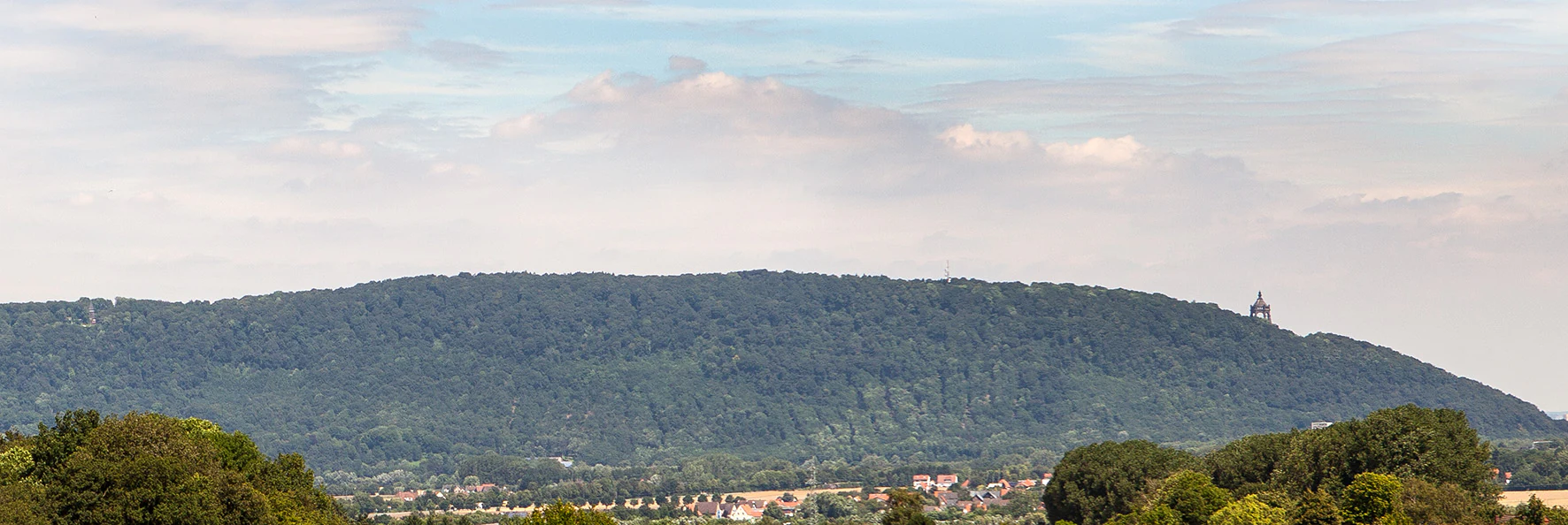
A wide shot of a forested hill ridge under a cloudy sky, with a small structure visible on the crest of the hill.
A view of the forested Wittekindsberg mountain ridge from the south.

Wittekindsberg Nature Reserve history and protected-area timeline

The Wittekindsberg Nature Reserve was formally designated in phases during 1990 and 1992, following the framework of the regional landscape plan for Porta Westfalica. Its establishment reflected growing recognition of the ecological value of the beech and mixed broadleaf forests on the southern Wiehengebirge, as well as the geological importance of the exposed sandstone and limestone cliffs along the ridge.

A later development in the reserve's conservation history was its overlap with the larger FFH-Gebiet Wälder bei Porta Westfalica, integrating the Wittekindsberg area into the European Natura 2000 network and aligning it with broader habitat protection objectives under EU nature law. The reserve is administered by the lower landscape authority (Untere Landschaftsbehörde) of the Kreis Minden-Lübbecke, continuing to be managed as part of the regional landscape planning framework for Porta Westfalica.

Wittekindsberg Nature Reserve landscape and geographic character

The landscape of the Wittekindsberg Nature Reserve is defined by the southern slopes and crest of the Wiehengebirge, where forested hills give way to a series of exposed rock faces along the ridge. The terrain rises from the vicinity of the Bundesstraße 61 in the south to the forested summit zone of the Wittekindsberg and the nearby Häverstädter Berg in the north. Steep slopes, rocky outcrops, and shaded valleys combine to create varied topography within a relatively compact area of around 114 hectares.

Geologically, the reserve sits on Jurassic-age substrate. The upper cliffs belong to the Heersumer Schichten of the Malm, the uppermost stage of the Jurassic in the regional sequence, and include both sandstone formations characteristic of the Porta area and limestone klippen. These formations weather into rugged cliff profiles and scree that border the woodland. Lower in the reserve, the Wolfsschlucht preserves an anthropogenic exposure in Dogger-age rocks, offering a window into the deeper, older Jurassic layers below the ridge.

The visual impression of the reserve is one of dense deciduous forest interlaced with sun-lit rock. From southern viewpoints, the wooded mass of the Wittekindsberg dominates the skyline, broken by pale bands of exposed cliff where the vegetation cannot take hold. The combination of forest regolith, cliff faces, and shallow soils gives the landscape a characteristic transitional appearance between the wooded heights of the Wiehengebirge and the more open, populated terrain toward the Weser valley to the south.

Wittekindsberg Nature Reserve ecosystems, habitats, and plant life

Ecologically, the reserve is shaped by its position on the southern Wiehengebirge, where a continental-temperate climate supports classic central European broadleaf forest. Beech (Fagus) forms the backbone of the canopy across most of the reserve, while mixed stands of mountain elm, sycamore maple, and small-leaved linden produce the specific associations highlighted in the reserve's designation, including Bergulmen-Ahornwald and Ahorn-Lindenwald. This forest mosaic supports a layered habitat structure, from tall canopy through shrub layer to leaf-litter-rich forest floor, each hosting its own communities of plants and invertebrates.

The cliff habitats along the ridge introduce a sharply different ecological zone. Sun-exposed sandstone and limestone klippen create dry, warm microclimates that contrast with the cool, shaded forest below. These conditions support vegetation and animal communities adapted to rocky substrates and high solar exposure, including thermophilic plant species and warmth-loving insects that find refuge in cracks, ledges, and scree. The cliff-forest interface is therefore a key structural feature of the reserve, blending forest interior habitat with edge and rock habitat within a short distance.

Because most of the reserve also lies within the FFH-Gebiet Wälder bei Porta Westfalica, the ecological value of the Wittekindsberg forests is recognized at the European level, with management aimed at maintaining the characteristic woodland communities and the rare geological exposures that the reserve was designed to protect.

Wittekindsberg Nature Reserve wildlife and species highlights

The wildlife significance of the Wittekindsberg Nature Reserve lies less in large mammals and more in the often-overlooked communities of insects and other invertebrates that depend on its specialized habitats. The combination of mature deciduous forest with abundant dead and decaying wood, and sun-exposed cliff faces, supports a community of warmth-loving, rock-dwelling insects alongside saproxylic, or wood-dwelling, species. These insect groups are a particular reason for the reserve's designation, as many are nationally rare or in decline elsewhere in North Rhine-Westphalia.

The woodland insect fauna is tied closely to the structure of the beech, elm, maple, and linden stands, where old trees, fallen logs, and standing deadwood provide breeding substrates for beetles, flies, and other invertebrates. On the cliffs and rocky outcrops along the summit ridge, warm microclimates allow thermophilic insects to persist in conditions rarely found elsewhere in the immediate region. Birds typical of mature deciduous forest in the Wiehengebirge, including canopy and edge species associated with such woodland mosaics, also find habitat within the reserve, although the German-language source does not enumerate specific bird species.

Wittekindsberg Nature Reserve conservation status and protection priorities

The principal conservation value of the Wittekindsberg Nature Reserve is the preservation of beech and mixed broadleaf forest communities on the southern Wiehengebirge, which have become increasingly rare in the wider regional landscape due to forestry, land-use change, and fragmentation. By formally protecting stands of mountain elm-sycamore maple and maple-linden woodland, the reserve safeguards ecosystem types that are otherwise difficult to maintain in a region historically shaped by agriculture and settlement.

A second pillar of the reserve's conservation role is the protection of natural and artificial geological exposures, including the sandstone and limestone cliffs of the Heersumer Schichten along the ridge and the Dogger-era exposure at the Wolfsschlucht. These outcrops are not only geologically valuable but also support rare insect communities, linking geological heritage with living biodiversity conservation.

Most of the reserve's forest area is also part of the FFH-Gebiet Wälder bei Porta Westfalica (DE-3719-301), embedding the site within the Natura 2000 network and aligning national-level protection with European habitat conservation goals. This dual designation gives the Wittekindsberg increased weight in regional conservation planning and ties its management to broader efforts across the Wiehengebirge and toward the Weser valley.

Wittekindsberg Nature Reserve cultural meaning and human context

The Wittekindsberg forms part of the southern Wiehengebirge cultural landscape in the Minden-Lübbecke region, where forested ridges and the gateway to the Weser valley around Porta Westfalica have historically shaped local identity and land use. The forest reserve reflects long-standing recognition of the ridge as both a natural landmark and a definitional feature of the local geography, with the cliffs and wooded slopes documented in regional landscape planning. Although the source material does not provide detail on indigenous or prehistoric use of the area, the formal landscape plan of Porta Westfalica indicates that the site has been integrated into regional land-use and conservation thinking for several decades.

Top sights and standout views in Wittekindsberg Nature Reserve

The reserve's highlights include the Habichtswand cliff formation, the Dogger-era geological exposure at the Wolfsschlucht, and the Bergulmen-Ahornwald and Ahorn-Lindenwald forest associations that anchor its ecological identity. Together, these features combine a small but representative cross-section of southern Wiehengebirge geology with mature broadleaf woodland and a Natura 2000-level protection framework, all within a compact area of about 114 hectares.

Monthly climate preview

Track monthly temperature ranges and precipitation rhythm across the park coordinate

Wittekindsberg Climate Normals and Long Term Temperature Patterns

Long term data reveals continuous shifts in average temperature and precipitation across the Wittekindsberg coordinate from January through December. Reviewing the complete twelve month climate profile provides deeper context for analyzing annual weather patterns across the protected landscape.
Annual mean9 °C
1 °C18 °C
Jan
Feb
Mar
Apr
May13°
Jun16°
Jul18°
Aug18°
Sep14°
Oct
Nov
Dec
Warmest month
July

18.1 °C

Coolest month
January

0.5 °C

Wettest month
December

2.6 mm/day

Driest month
April

1.6 mm/day

Park location guide

Geography guide, regional context, and park location map for Wittekindsberg Nature Reserve

Wittekindsberg Nature Reserve park geography, regions, and map view in Germany

Understand where Wittekindsberg Nature Reserve sits in Germany through a broader geographic reading of the surrounding landscape, nearby location context, and its mapped position within the national park landscape.

How Wittekindsberg Nature Reserve fits into Germany

Germany is a federal republic in Western and Central Europe with a population of over 83 million across sixteen constituent states. It is Europe's largest economy by nominal GDP and a major global exporter and importer. The capital is Berlin, and the country borders Denmark, Poland, Czech Republic, Austria, Switzerland, France, Luxembourg, Belgium, and the Netherlands.

Wider geography shaping Wittekindsberg Nature Reserve in Germany

Germany is located in Western and Central Europe, spanning 357,022 km². It borders Denmark to the north, Poland and the Czech Republic to the east, Austria and Switzerland to the south, and France, Luxembourg, Belgium, and the Netherlands to the west. The country has coastlines on the Baltic Sea and North Sea to the north, with the Alps located in the southern region.

Map view of Wittekindsberg Nature Reserve

Use this park location map to pinpoint Wittekindsberg Nature Reserve in Germany, understand its exact geographic position, and read its mapped placement within the surrounding landscape more clearly.

Pigeon | © OpenStreetMap contributors

Location context for Wittekindsberg Nature Reserve

North Rhine-Westphalia

Examine the cliff formations, mature beech forests, and ridge habitats of the reserve.

Wittekindsberg Photos and Landscapes: Visual Exploration of Protected Terrain

Visual documentation captures the rugged topography, exposed Jurassic rock faces, and dense broadleaf woodlands defining the protected reserve. Detailed photography reveals the terrain, cliff ecology, and transition zones connecting the forested heights to the valley below.

A wide shot of a forested hill ridge under a cloudy sky, with a small structure visible on the crest of the hill.

Park atlas

Compare adjacent forest reserves, ridge habitats, and regional conservation landscapes

Other Parks Near Wittekindsberg and Surrounding Protected Areas to Explore

Browse nearby national parks and protected areas sharing similar low mountain terrain and beech forest ecosystems. Continuing into surrounding regional landscapes allows broader comparison of protected habitats across the Wiehengebirge.
A horizontal watercolor painting depicting a soft, impressionistic forest landscape with green trees, subtle hints of pink and purple, and a light background.
Nature reserveNorth Rhine-Westphalia
About 12 km away#1 closest

North

Heisterholz: Protected Oak Forests and Wetland Mosaics in North Rhine-Westphalia

Geographic overview of a key nature reserve and forest belt

Explore the structured geography of Heisterholz, a state-protected lowland forest in the Rahden-Diepenauer Geest. This site details the composition of its oak-dominated woodlands, spring zones, and stream valleys, illustrating its critical function within the interconnected forest chain of northern Germany.

Area
8.8 km²
Relief
Lowland
Climate
Temperate
Scope
Terrestrial
A watercolor illustration of a calm stream flowing through a green valley with trees and gentle hills in the background.
Nature reserveNorth Rhine-Westphalia
About 12 km away#2 closest

Southwest

Naturschutzgebiet Mittelbach Nature Reserve: Mapped Protected Landscapes in Vlotho

Classic Siek stream valley geography and riparian woodland habitats

The Naturschutzgebiet Mittelbach is a protected area in eastern Westphalia that defines the local landscape with its deeply cut moisture-rich valley. This site serves as a vital reference for the traditional Ravensberger Siek morphology, preserving a compact ecological network of sedge communities, beech forest patches, and riparian alder stands along a two-kilometer stream stretch.

Area
0.341 km²
Established
1998
Relief
Upland
Climate
Temperate
A soft watercolor illustration depicting a line of trees and greenery along a shoreline with rolling hills in the background.
Nature reserveKreis Lippe
About 12 km away#3 closest

Southeast

Naturschutzgebiet Abgrabung Stemmen: Protected Landscape and Regional Geography in Kreis Lippe

Post-mining habitat restoration in North Rhine-Westphalia

Gain insights into the geography and conservation status of Naturschutzgebiet Abgrabung Stemmen. This 20-hectare nature reserve in Kreis Lippe showcases the development of ruderal grasslands, willow pioneer woodland, and wetland ecosystems across a reclaimed industrial site.

Area
0.2 km²
Established
1995
A watercolor illustration of a rural landscape with a single prominent tree in the foreground, green hills in the distance, and soft fields in between.
Nature reserveNordrhein-Westfalen
About 14 km away#4 closest

South

Kleiner Selberg Nature Reserve: Protected Landscape and Geographic Mapping

Essential geographic context for the Lipper Bergland protected areas

Kleiner Selberg stands as a prominent hill and nature reserve within the Kreis Herford region. Its landscape is defined by a dense population of juniper shrubs and restored heathland, offering a vital ecological corridor in the Weserbergland. Explore the spatial arrangement of its woodland patches and pasture slopes that characterize this protected hill environment.

Area
0.136 km²
Established
1971
Relief
Mountain
Climate
Temperate
Watercolor illustration of a peaceful lakeside scene at Lahder Marsch, featuring birch trees, marshy vegetation, and a calm water surface.
Nature reserveKreis Minden-Lübbecke
About 15 km away#5 closest

Northeast

Lahder Marsch Nature Reserve: Protected Wetland Mosaic in Kreis Minden-Lübbecke

A mapped sanctuary for migratory birds within the Weser floodplain.

Lahder Marsch is a designated nature reserve located in the Weser river valley, forming a chain of flooded gravel pits that sustain diverse avian populations. This protected landscape, characterized by open water, islands, and dense reed fringes, serves as a crucial habitat within the larger Weseraue Natura 2000 network, illustrating the geographic importance of restored extraction sites in lowland Germany.

Area
0.19 km²
Water
Major water bodies
Nature reserveNorth Rhine-Westphalia
About 16 km away#6 closest

North

Mindenerwald Protected Nature Reserve: Geography, Boundaries, and Forest Terrain

A vital deciduous woodland complex in northern North Rhine-Westphalia.

The Mindenerwald nature reserve represents a substantial forest tract characterized by sandy-soil oak woodlands and diverse ash-alder wetlands. This protected landscape serves as a critical node for habitat connectivity, hosting a complex mosaic of spring-fed marshes and mature trees that support important bird and bat species within the broader Minden-Lübbecke district.

Area
8 km²
Relief
Lowland
Scope
Terrestrial
Water
Minor water
A horizontal watercolor illustration featuring a stylized forest with shades of green and yellow trees against a backdrop of soft, faint hills.
Nature reserveNorth Rhine-Westphalia
About 20 km away#7 closest

West

Sonnenwinkel Nature Reserve: Protected Landscape and Forest Ecology in North Rhine-Westphalia

Calcareous beech forest and seasonal woodland habitats

Sonnenwinkel is a dedicated nature reserve near Lübbecke, North Rhine-Westphalia, providing a critical refugium for calcareous beech forest. The site exhibits distinct ecological boundaries defined by the Wiehengebirge foothills and remains a significant example of protected lowland forest habitat in Germany.

Area
0.047 km²
Relief
Mountain
Climate
Temperate
Access
Easy access
Watercolor painting of a green, rolling landscape with trees and soft hills, rendered in a minimalist, light-toned style on a white background.
Nature reserveNordrhein-Westfalen
About 21 km away#8 closest

Southwest

In der Masch Nature Reserve: Mapped Floodplain Geography in Nordrhein-Westfalen

Protected nature reserve with rare lowland meadow habitats.

In der Masch offers a focused look at protected lowland river-meadow terrain within Germany. This 23-hectare nature reserve in Nordrhein-Westfalen protects interconnected oat-grass grasslands, riparian wood fringes, and historical boundary markers, providing a distinct study in regional floodplain topography and habitat preservation.

Area
0.23 km²
Established
2002
IUCN
IV

Common questions about visiting, size, designation, and location context for Wittekindsberg Nature Reserve

Wittekindsberg Nature Reserve FAQs for park facts, access, geography, and protected area context

Find quick answers about Wittekindsberg Nature Reserve, including protected-area facts, park geography, trail and visitor context, and how the park fits into its surrounding country and regional landscape.
MoriAtlas Explorer

Continue Your Protected Areas Search Across the Global Atlas

Deepen your exploration by continuing the structured search for national parks and protected areas worldwide. Utilize the comprehensive filtering capabilities to compare different conservation landscapes and refine your understanding of global park geography. Discover more about the distribution and characteristics of protected natural areas.

Global natural geography