
Mori Atlas logo
Nature reserveWittenmoor

Mapping the hydrological terrain and ecological restoration of this vital raised bog in the Heidekreis district

Wittenmoor Nature Reserve: A Detailed Geographic Look at Protected Peatland Landscapes in Lower Saxony

(Naturschutzgebiet Wittenmoor)

Wittenmoor preserves a remnant raised bog landscape within Lower Saxony, Germany, spanning roughly 28 hectares near the Aue stream floodplain. This nature reserve protects a mosaic of bog pools with floating vegetation, moor heath, and alder swamp woodland. The site illustrates critical peatland conservation through active rewetting and woodland conversion, maintaining an essential, low-relief wetland habitat surrounded by agricultural territory.

raised bogpeatlandmoor heathswamp woodlandwet meadownature reserve
A flat-style digital illustration showing a landscape with a foreground meadow, a dense conifer forest, a central waterfall cascading from a cliff, and distant mountains under a soft sun.

Wittenmoor

Nature reserve

Park overview

Structured park overview, official facts, and landscape profile for Wittenmoor

Wittenmoor park facts, protected area profile, and essential visitor context

Review the core facts for Wittenmoor, including designation, size, terrain, visitor scale, habitats, and operating context in one park-focused overview.

About Wittenmoor

Wittenmoor is a designated nature reserve in the Heidekreis district of Lower Saxony, in north-central Germany. It lies within the municipality of Wietzendorf, just north of the village, and forms part of a broader network of protected peatland and wetland sites characteristic of the southeastern Lüneburg Heath area.

The reserve covers approximately 28 hectares and is divided into two separate sections. Its modest size belies its ecological importance: it preserves one of the last remnants of a raised bog (Hochmoor) in this part of the Heidekreis, including shallow peat-cutting areas that were historically worked by hand. These old diggings still hold the wet, nutrient-poor conditions that specialized bog plants require.

The site's conservation value lies in its mosaic of peatland habitats. The open bog surface is dominated by cottongrass, sphagnum mosses, and floating vegetation mats, with moor heath forming transitional zones around them. Toward the edges, wet swamp woodland (Bruchwald) frames the peatland, and in the northern part of the reserve a small remnant of a rush- and sedge-rich wet meadow (Nasswiese) survives.

Wittenmoor drains into the lowland floodplain of the Aue via small ditches, linking its hydrology to the broader wet landscape of the surrounding area. The reserve borders mostly farmland, with woodland on its western edge.

Protection and recognition

Explore documented terrestrial protection records and designation history for Wittenmoor.

Wittenmoor Protection Status and International Recognition Profile

Wittenmoor maintains a recorded terrestrial protection scope within official global databases. Structured management facts and international recognition metrics provide clear context for this protected area.

Protection details

Protection scope
Terrestrial
Transboundary protection
No
WDPA ID
319346
Park context

Deeper park guide and search-rich context for Wittenmoor

Wittenmoor history, landscape, wildlife, and travel context

Explore Wittenmoor through its history, landscape character, ecosystems, wildlife, conservation priorities, cultural context, and seasonal travel timing in a structured park guide built for atlas discovery and search intent.

Why Wittenmoor stands out

Wittenmoor is best known for protecting a surviving fragment of a raised bog landscape with traditional hand-cut peat diggings, surrounded by moor heath, floating bog mats, and swamp woodland at the edge of the Lüneburg Heath region.
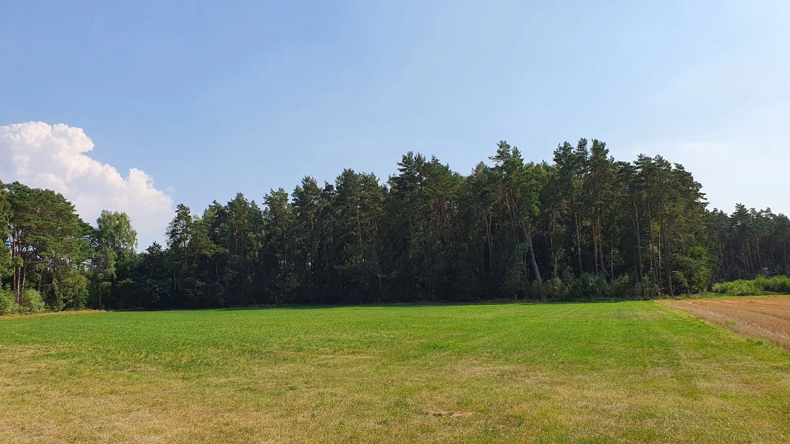
A wide shot of a green grassy field bordering a dense forest under a clear blue sky.
A view of the edge of the Wittenmoor nature reserve in Lower Saxony.

Wittenmoor landscape and geographic character

The Wittenmoor landscape is shaped almost entirely by peatland dynamics. The terrain lies gently at between roughly 68 and 76 meters above sea level, an extremely flat, low-relief setting typical of former bog plains. The reserve consists of two separated sections, both occupying a shallow depression in the landscape.

The central feature is a remnant raised bog with hand-cut peat extraction hollows of varying depth. These pools host floating mats of vegetation, moisture-loving mosses, and cottongrass. Around them lies moor heath, a drier transitional zone dominated by low shrubs and bog-adapted plants. At the outer margins, wet alder swamp woodland encircles the open bog.

Water movement in the area is slow and controlled. Ditches connect the bog to the broader Aue floodplain lowland, meaning the site's hydrology is tightly linked to surrounding agricultural drainage patterns.

Wittenmoor ecosystems, habitats, and plant life

Wittenmoor protects a compact but ecologically rich peatland ecosystem. The open bog pools and floating mats (Schwingrasen) support sphagnum mosses and cottongrass (Wollgräser); the surrounding moor heath hosts moorlily (Narthecium ossifragum, locally known as Beinbrech) and sweet gale (Gagelstrauch). These are classic indicators of acidic, nutrient-poor, waterlogged conditions.

Around the bog margins, swamp woodland adds structural diversity, while a surviving patch of rush- and sedge-rich wet meadow (Nasswiese) in the northern section preserves an additional wetland habitat under pressure from agricultural drainage across the region. The overall effect is a layered peatland mosaic: open water and floating mats at the center, heath in transition, woodland at the edges, and wet meadow as a remnant community.

Wittenmoor conservation status and protection priorities

Wittenmoor was placed under formal nature protection on 2 February 1999 and falls under the responsibility of the Heidekreis district as the lower nature conservation authority. It is classified as an IUCN Category IV protected area (Habitat/Species Management Area), reflecting its role in managing specific peatland habitats and species.

The reserve's conservation purpose is to maintain and develop what remains of a once more extensive raised bog landscape. Planned measures include rewetting the drying peat surfaces and removing encroaching woody vegetation (Entkusselung) to keep bog habitats open. A spruce stand included within the reserve boundary is being converted into near-natural mixed deciduous forest, aligning the woodland component with the wetland's ecological character.

Top sights and standout views in Wittenmoor

Wittenmoor is a small but ecologically focused reserve that preserves a surviving fragment of raised bog with hand-cut peat diggings, surrounded by moor heath, floating bog mats, swamp woodland, and a remnant wet meadow. Its compact size makes it a representative example of peatland conservation in the Heidekreis, with active management aimed at rewetting and habitat restoration.


Monthly climate preview

Track monthly temperature ranges and precipitation patterns across the representative coordinate.

Wittenmoor Climate Normals, Long-Term Temperature and Precipitation Rhythm

Wittenmoor records long-term average monthly temperatures spanning from sub-zero winter minimums to warm summer maximums alongside steady daily precipitation rates. Examining the full twelve-month profile provides complete historical climate data for this protected location.
Annual mean9 °C
0 °C18 °C
Jan
Feb
Mar
Apr
May13°
Jun16°
Jul18°
Aug18°
Sep14°
Oct
Nov
Dec
Warmest month
July

18.3 °C

Coolest month
January

0.4 °C

Wettest month
July

2.6 mm/day

Driest month
April

1.4 mm/day

Park location guide

Geography guide, regional context, and park location map for Wittenmoor

Wittenmoor park geography, regions, and map view in Germany

Understand where Wittenmoor sits in Germany through a broader geographic reading of the surrounding landscape, nearby location context, and its mapped position within the national park landscape.

How Wittenmoor fits into Germany

Germany is a federal republic in Western and Central Europe with a population of over 83 million across sixteen constituent states. It is Europe's largest economy by nominal GDP and a major global exporter and importer. The capital is Berlin, and the country borders Denmark, Poland, Czech Republic, Austria, Switzerland, France, Luxembourg, Belgium, and the Netherlands.

Wider geography shaping Wittenmoor in Germany

Germany is located in Western and Central Europe, spanning 357,022 km². It borders Denmark to the north, Poland and the Czech Republic to the east, Austria and Switzerland to the south, and France, Luxembourg, Belgium, and the Netherlands to the west. The country has coastlines on the Baltic Sea and North Sea to the north, with the Alps located in the southern region.

Map view of Wittenmoor

Use this park location map to pinpoint Wittenmoor in Germany, understand its exact geographic position, and read its mapped placement within the surrounding landscape more clearly.

Pigeon | © OpenStreetMap contributors

Location context for Wittenmoor

Lower Saxony

Examine the raised bog terrain, moor heath, and wetland habitats through detailed visual records

Wittenmoor Photos and Landscapes: Visual Exploration of the Protected Peatland

Visual records reveal the distinctive landscape character of Wittenmoor, showcasing remnant raised bogs, floating mats, and swamp woodland habitats. Examining these protected area views helps researchers understand peatland topography and regional conservation efforts more clearly.

A wide shot of a green grassy field bordering a dense forest under a clear blue sky.

Park atlas

Compare regional wetland habitats, lowland floodplains, and protected landscapes

Exploring Parks Near Wittenmoor and Surrounding Protected Areas

Browsing other protected areas near Wittenmoor reveals connected lowland habitats and regional peatland reserves across the surrounding landscape. Comparing adjacent nature reserves provides deeper geographic context into local conservation patterns and wetland ecosystems.
Nature reserveNiedersachsen
About 4.5 km away#1 closest

South

Wietzendorfer Moor: Geographic Analysis of Protected Bog and Wetland Landscapes

Nature reserve terrain in Niedersachsen, Germany

Discover the physical layout of Wietzendorfer Moor, an intricate nature reserve defined by restored raised bog habitats and historical polders. This atlas entry provides geographic context on the wet meadow systems and sand trails that define this unique Lüneburg Heath landscape, highlighting the spatial distribution of its protected parcels.

Area
2.1 km²
Established
1998
IUCN
IV
Relief
Lowland
Nature reserveLandkreis Heidekreis
About 13 km away#2 closest

East

Tal der Kleinen Örtze Nature Reserve: Geographic Atlas and Protected Area Context

Stream valley restoration in the Lüneburg Heath region

An essential look at the Tal der Kleinen Örtze nature reserve, which encompasses restored brook courses and floodplain woodland in Lower Saxony. This protected area serves as a significant example of hydrological recovery and habitat transition, ranging from alder forests to heathland remnants along the valley margins within the broader Heidekreis geography.

Area
4.5 km²
Established
1993
IUCN
IV
Relief
Lowland
Nature reserveLower Saxony
About 18 km away#3 closest

Southeast

Weesener Bach Nature Reserve: Protected Stream and Riparian Geography in the Celle District

Examining mapped boundaries and habitat preservation in Lower Saxony

Discover the geographic footprint of Weesener Bach, a dedicated nature reserve in the Celle district of Lower Saxony. This site focuses on the long term development of stream systems and associated riparian habitats, offering a clear look at specialized land management within the southern Lüneburg Heath region.

Area
2.58 km²
Established
1999
IUCN
IV
Scope
Terrestrial
A horizontal watercolor painting depicting a rolling heathland landscape with purple heather, evergreen trees, and a central water feature under a soft sky.
Protected landscapeLower Saxony
About 25 km away#4 closest

North

Naturpark Lüneburger Heide: Protected Landscape Map and Regional Geography

An expansive cultural landscape in northern Lower Saxony

Spanning over 1,000 square kilometers, Naturpark Lüneburger Heide preserves the largest contiguous inland heathlands in Central Europe. Use this atlas resource to understand the park's glacial terrain, including karst sinkholes and natural springs, as well as its status as a model region for sustainable conservation and traditional land management practices.

Area
1,097.85 km²
Established
1922
IUCN
V
Relief
Lowland
Nature reserveLandkreis Uelzen
About 27 km away#5 closest

Northeast

Wettenbosteler Moor Protected Area: Geographic Overview and Mapped Landscape Features

A resilient raised bog remnant in the Landkreis Uelzen heath forest

Spanning roughly thirteen hectares, Wettenbosteler Moor preserves a rare spring-fed bog habitat characterized by peat-forming vegetation and pine forest borders. This nature reserve offers deep insights into the drainage networks and lowland terrain of the Lüneburg Heath, mapping the transition between upland forest and valley mire.

Area
0.128 km²
Established
1977
IUCN
IV
Relief
Lowland
Nature reserveLandkreis Rotenburg (Wümme)
About 30 km away#6 closest

Northwest

Wümmeniederung mit Rodau, Wiedau und Trochelbach: Protected Wetland and Heath Landscape

Regional geography and floodplain connectivity in Landkreis Rotenburg

This nature reserve protects a sprawling lowland landscape characterized by the Wümme, Rodau, Wiedau, and Trochelbach rivers. The terrain features a mosaic of near-natural meandering streams, species-rich wet meadows, and rare raised bog remnants, providing a comprehensive overview of northern German lowland ecology.

Area
28.96 km²
Established
2020
IUCN
IV
Relief
Lowland
Nature reserveLower Saxony
About 37 km away#7 closest

West

Verdener Moor Nature Reserve: Geographic Atlas and Protected Area Context

Preserving raised bog ecosystems in Lower Saxony, Germany

Located in the municipality of Kirchlinteln, Verdener Moor functions as a protected nature reserve that demonstrates lowland peatland conservation. The landscape features a distinct mosaic of open water resulting from historical peat extraction, wet heath, and rewilded forest edges. This site offers valuable insight into the restoration of bog habitats through rewetting and bush removal within the broader geography of Lower Saxony.

Area
0.91 km²
Established
1989
IUCN
IV
Relief
Lowland
Nature reserveLower Saxony
About 43 km away#8 closest

West

Wedeholz Nature Reserve: Geographic Overview of Lower Saxony Protected Forest Landscapes

Ancient oak forests, Geest terrain, and protected wetland habitats

Wedeholz represents a dense forest conservation area in Lower Saxony, defined by its mature oak and beech communities. The reserve terrain transitions from dry sandy Geest soils to delicate pine swamp forests and floating bogs, supporting a high density of deadwood-dependent species and woodland biodiversity within a compact, protected boundary.

Area
1.83 km²
Established
2019
IUCN
IV
Relief
Upland

Common questions about visiting, size, designation, and location context for Wittenmoor

Wittenmoor FAQs for park facts, access, geography, and protected area context

Find quick answers about Wittenmoor, including protected-area facts, park geography, trail and visitor context, and how the park fits into its surrounding country and regional landscape.
MoriAtlas Explorer

Continue Your Protected Areas Search Across the Global Atlas

Deepen your exploration by continuing the structured search for national parks and protected areas worldwide. Utilize the comprehensive filtering capabilities to compare different conservation landscapes and refine your understanding of global park geography. Discover more about the distribution and characteristics of protected natural areas.

Global natural geography